- Colorado River Storage Project
-
 Glen Canyon Dam and Lake Powell near Page, Arizona. The dam and lake are major components in the Colorado River Storage Project's attempt to regulate the flow of the Colorado River.
The Colorado River Storage Project is a United States Bureau of Reclamation project designed to oversee the development of the upper Colorado River basin. The project provides hydroelectric power, flood control and water storage for participating states along the upper portion of the Colorado River and its major tributaries.[1]
Since its inception in 1956, the project has grown to include the participation of several related water management projects throughout the river's basin. The project's original scope, and primary focus, are the upper Colorado River itself, the Green River, the San Juan River, and the Gunnison River.
Participating states are Arizona, Utah, New Mexico, Colorado and Wyoming.
Contents
History
Attempts at managing the water supply in the upper Colorado River basin were first recorded in 1854 at Fort Supply in Wyoming, when water was diverted from Blacks Fork to irrigate local lands. Subsequent diversions of the waters in the Colorado basin led to preliminary investigations of means to develop the system as early as 1902 when the Bureau of Reclamation, then known as the Reclamation Service, was established.[2]
Serious consideration for the project began when the Colorado River Compact was signed in 1922 by the participating states, as well as the lower Colorado River states, California and Nevada. As a stipulation of that compact, the upper basin states were required to ensure an annual flow of no less than 7,500,000 acre feet (9.3 km3) be delivered to the lower basin states.[3] However, the annual flow of the Colorado River at Lee's Ferry in Arizona, the established dividing point, were extremely erratic, ranging from 4,000,000 acre feet (4.9 km3) to 22,000,000 acre feet (27 km3). This led to an inability of the upper basin states to meet the minimum delivery requirements to the lower states in dry years, and a loss of significant surpluses in wet years.
 Lee's Ferry, Arizona, is the dividing point between the upper and lower Colorado River basins.
In order to regulate the flow of the Colorado and ensure compliance with the compact, a study was undertaken that determined a series of dams and reservoirs on the river and its tributaries would be necessary. A joint effort between the Upper Colorado River Commission, the Bureau of Reclamation and other federal agencies delivered a report with proposed projects to the United States Congress in 1950.
Among the proposed projects was a dam to be constructed on the Green River in Echo Park, in Dinosaur National Monument in Colorado. The proposal created controversy and sparked the ire of Sierra Club director David Brower, who embarked on a national campaign to rescue the park. As part of a compromise, the proposed dam was stricken from the project and replaced with another dam in Glen Canyon, Arizona. Brower, who had not personally visited Glen Canyon prior to the compromise, later lamented the deal, describing it as "the worst mistake of his career" and "'the biggest sin I ever committed'".[4]
A revised, and slightly pared down, version of the plan was passed in to law by Congress in 1956. The legislation called for the construction of dams, reservoirs and related works at Curecanti in Colorado, Flaming Gorge in Wyoming, Navajo in New Mexico and Glen Canyon in Arizona. All but the Navajo project were to include power generation capabilities; the Navajo project was intended as flood control only. Also included in the legislation were several related projects in the Colorado River basin.[5]
Project scope
The Colorado River Storage Project is made up of four separate units, spread along the upper Colorado basin and its major tributaries. Also included are several participating projects located throughout the system.
As a whole, the system provides a storage capacity of approximately 34,000,000 acre feet (42 km3) of water. This capacity is released to meet the Colorado River Compact's delivery requirements during periods of low flow in the system. Additionally, three of the units provide hydroelectric power to major markets in the southwest.[1]
Lee's Ferry in Arizona serves as the southern boundary point for the project, which encompasses the Colorado River upstream from this point and all tributaries.
Glen Canyon Unit
Main articles: Glen Canyon Dam and Lake Powell Glen Canyon Dam, with Lake Powell in the background.
The Glen Canyon Unit, which consists of the Glen Canyon Dam, Lake Powell and the Glen Canyon Powerplant, is the largest and most important unit of the system. [1] While the dam is located near Page in northern Arizona, the majority of Lake Powell resides in southern Utah. With a total storage capacity of 27,000,000 acre feet (33 km3) of water in Lake Powell, the Glen Canyon Unit accounts for over 64% of the system's overall water storage capacity. The 1,296 megawatt capacity of the dam's hydroelectric generators accounts for almost 75% of the overall generating capacity of the project.[6]
In spite of its importance to the system, the Glen Canyon Unit has also been the source of controversy even before it began operating in 1964. Sierra Club director David Brower, who was partially responsible for the location of the dam as part of a compromise, later regretted the decision.[4] Former Arizona Senator Barry Goldwater, who was a proponent of the dam in the beginning, later recanted his opinion and admitted that he, too, had regretted supporting the project.[7] Recent calls for the draining of Lake Powell and the restoration of Glen Canyon by environmental groups such as Sierra Club have resulted in the founding of several advocacy groups for the cause such as Living Rivers and Friends of Glen Canyon, as well as opposition groups such as Friends of Lake Powell.
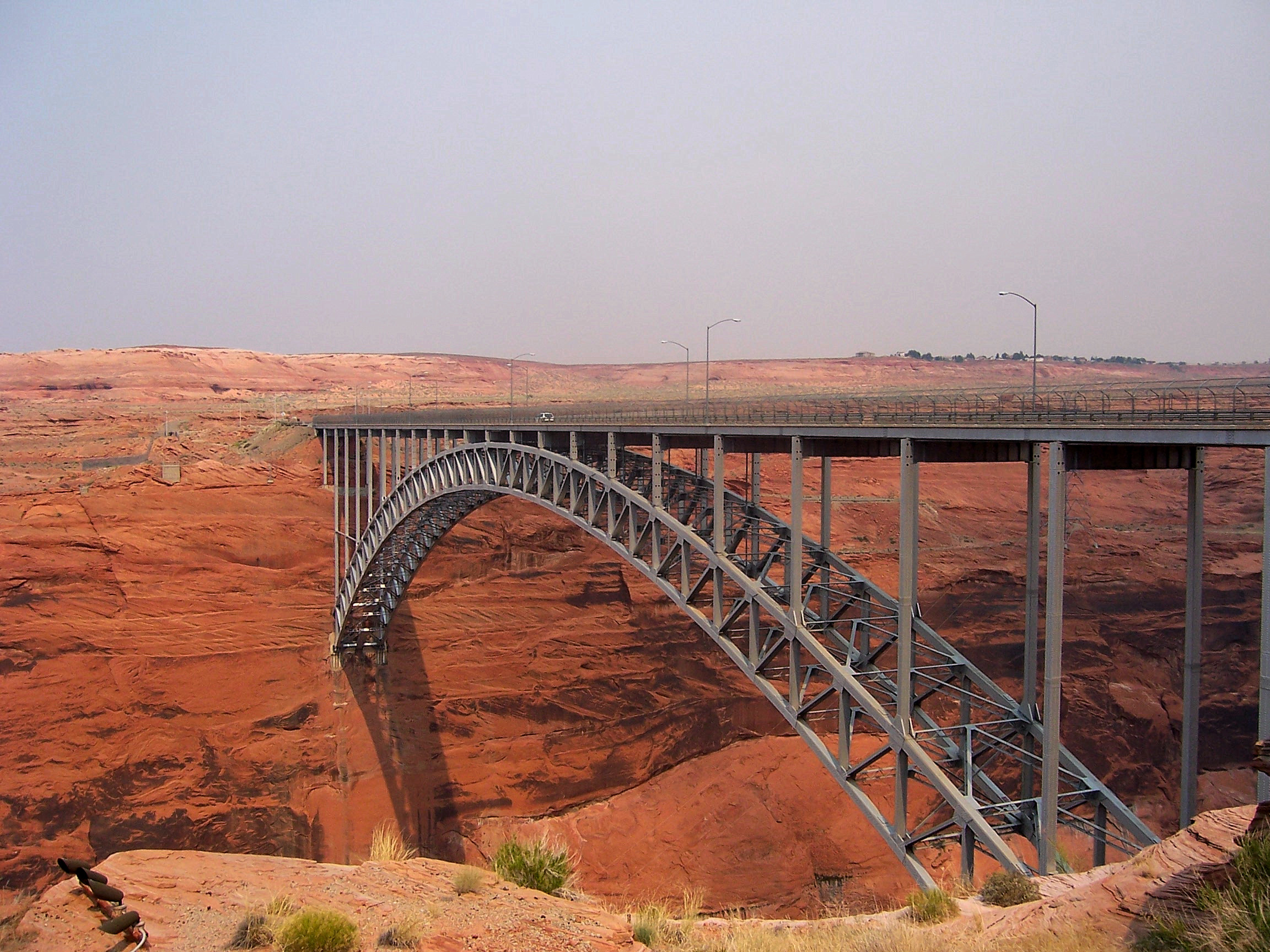
 Glen Canyon Bridge
Given the importance of the unit to the project as well as its impact as a tourist destination to the region, restoration efforts face significant opposition and there currently exist no plans to cease operations at Glen Canyon.
Not directly a part of the project but built as a direct result of it, the Glen Canyon Dam Bridge was constructed over the river in 1959. At the time of its completion it was the highest arch bridge in the world.[1] It currently serves as one of only two bridges to cross the Colorado River between Lake Mead and Lake Powell, carrying the majority of the traffic between northern Arizona and southern Utah.
Flaming Gorge Unit
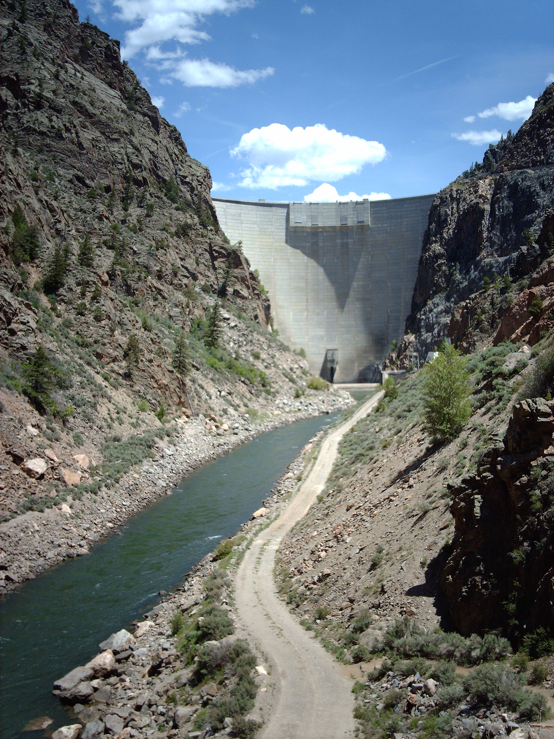
Main article: Flaming Gorge ReservoirMain article: Flaming Gorge Dam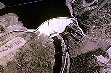 Flaming Gorge Dam and reservoir from the air.
The Flaming Gorge Unit consists of the Flaming Gorge Dam and the Flaming Gorge Reservoir, and the dam's powerplant. The dam impounds the Green River near Green River, Wyoming. Portions of the reservoir spill over into northeastern Utah.
Completed in 1964, the dam provides water storage and hydroelectric generation, as well as flood control on the Green River, the primary tributary to the Colorado. The powerplant in the dam has a capacity of 153 megawatts or about 8.5% of the entire system.[8]
Main article: Navajo ReservoirThe Navajo Unit consists of the Navajo Dam and the Navajo Reservoir. The dam impounds the San Juan River near Farmington, New Mexico.
The dam was completed in 1963, and was actually the first of the units in the project to be completed. Unlike the subsequent dams, Navajo Dam did not have any power generating capacity when built. A small plant with a capacity of 32 MW was installed in 1983 in conjunction with the city of Farmington to generate local power.[9]
Aspinall Unit
The Aspinall Unit consists of 3 dams and reservoirs on the Gunnison River in Colorado. It is the only unit in the project to be made up of more than one dam or reservoir.
The Aspinall Unit was originally named the Curecanti Unit, but was renamed for former congressman Wayne N. Aspinall in 1980.[10] Aspinall had been a strong proponent of water reclamation projects in Colorado and the western US in general, and was seen as a key opponent to David Brower in the fight to enact the Colorado River Storage Project. Brower was known to have fought regularly with Aspinall, going so far as to state that he had seen "dream after dream dashed on the stony continents of Wayne Aspinall."[11]
 Blue Mesa Dam.
As a whole, the Aspinall Unit has a generating capacity of about 290 megawatts, or about 17% of the entire Colorado River Storage Project, making it the second most productive unit after Glen Canyon.
Blue Mesa Dam
Main article: Blue Mesa DamThe Blue Mesa Dam impounds the Gunnison River upstream of the Morrow Point Dam, making it the first dam the river passes through. The dam was completed in 1966 and has an electric generating capacity of 86,400 kilowatts, or about 30% of the Aspinall Unit's generating capacity. [12]
Morrow Point Dam
Main article: Morrow Point Dam Gunnison River downstream from the Morrow Point Dam.
The Morrow Point Dam impounds the Gunnison River downstream from the Blue Mesa Dam but upstream of the Crystal Dam, putting it in the center of the Aspinall Unit. Completed in 1968, Morrow Point is the largest and most productive of the Aspinall dams. Morrow Point has a generating capacity of 173,334 kilowatts, making it the second most productive dam in the entire Colorado River Storage Project system. It provides about 60% of the Aspinall Unit's generating capacity.[13]
Additionally, the Morrow Point Dam is the first thin-arch concrete dam to be build in the Colorado River Storage Project system.[1]
Crystal Dam
Main article: Crystal DamThe Crystal Dam impounds the Gunnison River about 6 miles (10 km) downstream from the Morrow Point Dam, making it the final dam in the Aspinall Unit. Completed in 1976, it is the last dam in both the Aspinall Unit and the Colorado River Storage Project to be completed, marking the final completion of the system as a whole.
Crystal Dam has the smallest capacity of the hydroelectric dams in the system, providing some 31,500 kilowatts capacity, or just over 1% of the Aspinall Unit's capacity.[14]
Participating projects
A number of water management projects in various locations of the upper Colorado River basin are considered participating projects in the Colorado River Storage Project. These projects are financially related to the CRSP but are not considered a part of the project itself.
11 projects were included as participating projects in the 1956 legislation. These projects include:
- Central Utah Project, numerous dams and reservoirs in central Utah
- Emery County Project, covering dams in Emery County, Utah
- Florida Project, on the Florida River in southwestern Colorado
- Hammond Project, on the San Juan River in northeastern New Mexico
- La Barge Project in Wyoming
- Lyman Project, on the Blacks Fork and Smiths Fork of the Green River, primarily in Wyoming
- Paonia Project in west-central Colorado
- Pine River Project in western Colorado
- Seedskadee Project on the upper Green River Basin in Wyoming
- Silt Project in west-central Colorado
- Smith Fork Project in west-central Colorado
Wyoming's Eden Project was authorized independently in 1949. It was tied to the Colorado River Storage Project by the terms of its own authorization.
An amendment to the legislation in 1962 added two projects to the participants list:
- San Juan-Chama Project, diverting water from the San Juan River basin out to the Rio Grande basin
- Navajo Indian Irrigation Project, performed on behalf of the Bureau of Indian Affairs
A 1964 amendment added three more projects:
- Bostwick Park Project, involving Cimarron Creek, a tributary of the Gunnison River
- Fruitland Mesa Project in Colorado
- Savery-Pot Hook Project in Colorado and Wyoming
The Colorado River Basin Project Act in 1968 added a final five projects to the participants list:
- Animas-La Plata Project in Colorado and New Mexico
- Dallas Creek Project, a tributary of the Uncompahgre River, in turn a tributary of the Gunnison River
- Dolores Project in southwestern Colorado
- San Miguel Project, Colorado
- West Divide Project, Colorado
Four projects, the Fruitland Mesa, Savery-Pot Hook, San Miguel and West Divide Projects, were later found to be infeasible and removed from the list.[1]
Project impact
 Lake Powell
The four primary units of the Colorado River Storage Project have a maximum output of 1,813 megawatts of hydroelectric power at any given time, comparable to a large coal-fired generating station such as the Navajo Generating Station.
The Blue Mesa and Navajo Dams, built primarily to function for flood control purposes, have saved approximately $10 million in flood-related costs up to the year 1999.[1]
Additionally, the various units of the project have created significant recreational opportunities throughout the otherwise arid southwest regions.
References
- ^ a b c d e f g "Colorado River Storage Project". Bureau of Reclamation. Archived from the original on 2008-03-17. http://web.archive.org/web/20080317064511/http://www.usbr.gov/dataweb/html/crsp.html. Retrieved 2008-05-22.
- ^ "THE BUREAU OF RECLAMATION:A Very Brief History". US Bureau of Reclamation. http://www.usbr.gov/history/borhist.html. Retrieved 2008-05-22.
- ^ Gelt, Joe (1997). "Sharing Colorado River Water: History, Public Policy and the Colorado River Compact". University of Arizona. http://ag.arizona.edu/AZWATER/arroyo/101comm.html. Retrieved 2008-05-22.
- ^ a b Adler, Robert W. (2007). Restoring Colorado River Ecosystems: A Troubled Sense of Immensity. Chicago: Island Press. pp. 15. ISBN 1597260576.
- ^ "COLORADO RIVER STORAGE PROJECT-AUTHORITY TO CONSTRUCT, OPERATE AND MAINTAIN". US Congress. 1956-4-11. http://www.usbr.gov/lc/region/g1000/pdfiles/crspuc.pdf. Retrieved 2008-05-22.
- ^ "Glen Canyon Powerplant". Bureau of Reclamation. 2005-12-28. Archived from the original on 2008-03-11. http://web.archive.org/web/20080311070518/http://www.usbr.gov/power/data/sites/glencany/glencany.html. Retrieved 2008-05-22.
- ^ McKinnon, Shaun (2007-05-28). "At age 50, dam still generates love, hate". The Arizona Republic. http://www.azcentral.com/arizonarepublic/news/articles/0528dam-anniversary0528.html. Retrieved 2008-05-22.
- ^ "Flaming Gorge Dam". Bureau of Reclamation. Archived from the original on 2008-03-13. http://web.archive.org/web/20080313060616/http://www.usbr.gov/dataweb/dams/ut10121.htm. Retrieved 2008-05-22.
- ^ "Navajo Dam". Bureau of Reclamation. Archived from the original on 2008-03-13. http://web.archive.org/web/20080313055802/http://www.usbr.gov/dataweb/dams/nm00120.htm. Retrieved 2008-05-22.
- ^ "Aspinall, Wayne N., Unit". Recreation.gov. http://www.recreation.gov/recAreaDetails.do?contractCode=NRSO&recAreaId=1182&contractCode=129. Retrieved 2008-05-22.
- ^ Schulte, Steven C. (2002). Wayne Aspinall and the Shaping of the American West. Norman, Oklahoma: University of Oklahoma Press. ISBN 9780870816659.
- ^ "Blue Mesa Powerplant". Bureau of Reclamation. 2005-12-28. Archived from the original on 2008-03-29. http://web.archive.org/web/20080329035921/http://www.usbr.gov/power/data/sites/bluemesa/bluemesa.html. Retrieved 2008-05-22.
- ^ "Morrow Point Power Plant". Bureau of Reclamation. 2005-12-29. Archived from the original on 2008-03-03. http://web.archive.org/web/20080303233736/http://www.usbr.gov/power/data/sites/morrowpt/morrowpt.html. Retrieved 2008-05-22.
- ^ "Crystal Powerplant". Bureau of Reclamation. 2005-12-28. Archived from the original on 2008-03-03. http://web.archive.org/web/20080303233534/http://www.usbr.gov/power/data/sites/crystal/crystal.html. Retrieved 2008-05-22.
External links
Glen Canyon Dam · Flaming Gorge Dam · Navajo Dam · Crystal Dam · Morrow Point Dam · Blue Mesa Dam
Reservoirs Water resources projects Bostwick Park Project · Central Utah Project · Dallas Creek Project · Dolores Project · Eden Project · Emery County Project · Florida Project · Hammond Project · Lyman Project · Navajo Indian Irrigation Project · Paonia Project · Pine River Project · San Juan-Chama Project · Seedskadee Project · Silt Project · Smith Fork Project
Rivers Colorado River · Green River · Gunnison River · San Juan River
Categories:- Colorado River
- History of the American West
- Colorado River Storage Project


Wikimedia Foundation. 2010.