- Geography of Kiribati
-

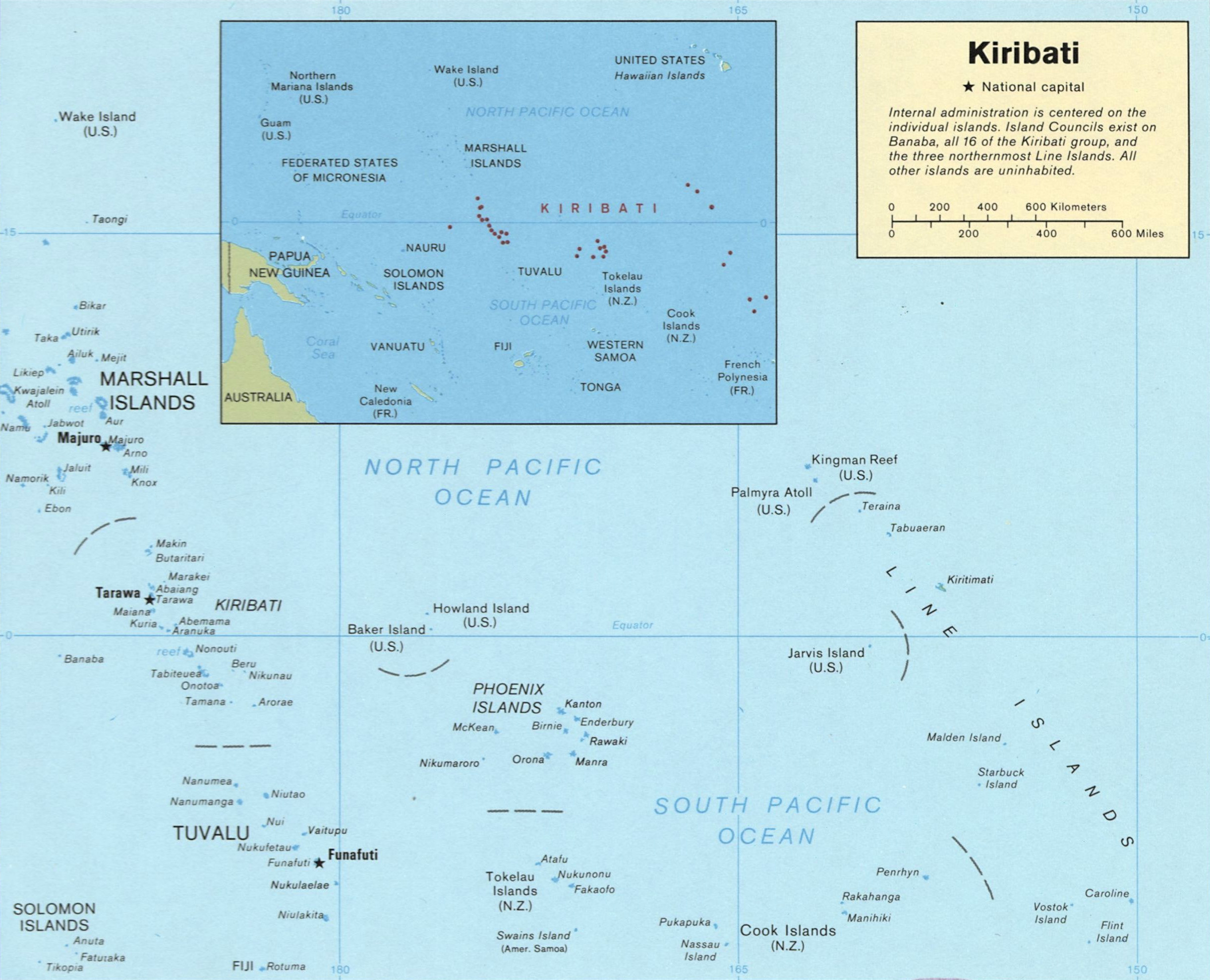
This article describes the geography of the Republic of Kiribati. Kiribati consists of 32 atolls and one island scattered over all four hemispheres in an expanse of ocean equivalent in size to the continental United States. The islands lie roughly halfway between Hawaiʻi and Australia in the Micronesian region of the South Pacific. The three main island groupings are the Gilbert Islands, Phoenix Islands, and Line Islands. On 1 January 1995 Kiribati moved the International Date Line to include its easternmost islands and make it the same day throughout the country.
Kiribati includes Kiritimati (Christmas Atoll; in the Line Islands), the largest coral atoll (in terms of land area, not dimensions) in the world, and Banaba (Ocean Island), one of the three great phosphate rock islands in the Pacific.
Most of the land on these islands is less than two metres above sea level. A 1989 United Nations report identified Kiribati as one of the countries that could completely disappear in the 21st century if steps are not taken to address global climate change.
Owing to a population growth rate of more than 2% and the overcrowding around the capital of South Tarawa, a program of migration was begun in 1989 to move nearly 5,000 inhabitants to outlying atolls, mainly in the Line Islands. A program of resettlement to the mostly uninhabited Phoenix Islands was begun in 1995.
Statistics
 Kiribati's Gilbert Islands
- Location
- Oceania, group of islands in the Pacific Ocean, straddling the equator, about one-half of the way from Hawaii to Australia; note - on 1 January 1995, Kiribati unilaterally moved the International Date Line from the middle of the country to include its easternmost islands and make it the same day throughout the country
- Geographic coordinates
- 1°25′N 173°00′E / 1.417°N 173°E
- Map references
- Oceania
- Area
-
- Total: 717 km2 (277 sq mi)
- Land: 717 km2
- Water: none
- Note: includes three island groups - Gilbert Islands, Line Islands, Phoenix Islands
- Land boundaries
- none
- Coastline
- 1,143 km (710 mi)
- Maritime claims
-
- Exclusive economic zone: 200 nmi (370 km; 230 mi)
- Territorial sea: 12 nmi (22 km; 14 mi)
- Climate
- Tropical; marine, hot and humid, moderated by trade winds
- Terrain
- Mostly low-lying coral atolls surrounded by extensive reefs
- Elevation extremes
-
- Lowest point: Pacific Ocean 0 m
- Highest point: unnamed location on Banaba 81 m (266 ft)
- Natural resources
- Phosphate (production discontinued in 1979)
- Land use
-
- Arable land: 0%
- Permanent crops: 51%
- Permanent pastures: 0%
- Forests and woodland: 3%
- Other: 46% (1993 est.)
- Irrigated land
- NA
- Natural hazards
- Typhoons can occur any time, but usually November to March; occasional tornadoes; low-level of some of the islands make them very sensitive to sea-level rise
- Environment - current issues
- Heavy pollution in lagoon of south Tarawa atoll due to heavy migration mixed with traditional practices such as lagoon latrines and open-pit dumping; ground water at risk
- Environment - international agreements
-
- Party to: Biodiversity, Climate Change, Desertification, Endangered Species, Law of the Sea, Marine Dumping, Ozone Layer Protection
- Signed, but not ratified: None of the selected agreements
- Geography - note
- 20 of the 33 islands are inhabited; Banaba (Ocean Island) in Kiribati is one of the three great phosphate rock islands in the Pacific Ocean - the others are Makatea in French Polynesia, and Nauru.
Extreme points
This is a list of the extreme points of Kiribati, the points that are farther north, south, east or west than any other location.
- Northern-most point – Teraina (Washington Island), Line Islands
- Eastern-most point – Caroline Island, Line Islands
- Southern-most point – Flint Island, Line Islands
- Western-most point - Banaba Island
Geography of Oceania Sovereign states Dependencies and
other territories- American Samoa
- Christmas Island
- Cocos (Keeling) Islands
- Cook Islands
- Easter Island
- French Polynesia
- Guam
- Hawaii
- New Caledonia
- Niue
- Norfolk Island
- Northern Mariana Islands
- Pitcairn Islands
- Tokelau
- Wallis and Futuna
Kiribati Gilbert Islands 
Phoenix Islands Line Islands West of Gilberts Reefs Categories:


Wikimedia Foundation. 2010.