- Port Oneida Rural Historic District
Infobox_nrhp | name =Port Oneida Rural Historic District
nrhp_type =
caption = Nineteenth century farming
location=Leelanau Peninsula , Michigan
lat_degrees = 44
lat_minutes = 54
lat_seconds = 47
lat_direction = N
long_degrees = 86
long_minutes = 01
long_seconds = 13
long_direction = W
locmapin = Michigan
area =Northern Michigan
built =mid 1800s to mid 1900s
architect=
architecture=
added =June 1 ,1997
governing_body =National Park Service
refnum = cite web|url= http://www.nationalregisterofhistoricplaces.com/mi/Leelanau/districts.html|title=National Register Information System|date=2008-05-30|work=National Register of Historic Places|publisher=National Park Service] 97000563Port Oneida Rural Historic District is part of the
Sleeping Bear Dunes National Lakeshore . It consists of a set of farms in theLeelanau Peninsula ofNorthern Michigan that are typical of Northern European settlers throughout theMidwestern United States in the later part of the nineteenth century. [http://www.nps.gov/slbe/planyourvisit/portoneida.htm Port Oneida Rural Historic District] ] [http://www.nps.gov/archive/slbe/hist_prp.htm Historic Properties Management Plan] ]The district was farmed for over 100 years by local farmers of
subsistence farm s. The houses and fields were passed down through the families. What is represented in the district is the practice of land use, architecture and the evolution of agricultural technology common to the upper Great Lakes region. It is very rare to find such a large collection of farms of this time period that are free from modern technology.Port Oneida Rural Historic District has 121 buildings, 20 structures and 18 farmsteads. [http://www.nps.gov/slbe/planyourvisit/povirtualtour.htm Port Oneida Virtual Tour] ] [http://www.phsb.org/tour/?id=101 Port Oneida Rural Historic District map of structures] ] The district is over 3400 acres of farming area preserved as it was in the late 1800s to the mid 1900s. It is the largest historic agricultural community in the United States under government ownership that is fully protected by the government. [http://www.glenarborsun.com/archives/2006/07/index.html Glen Arbor Sun - July 27, 2006] ] [http://www.glenarborsun.com/archives/2007/08/reenacting_the.html Glen Arbor Sun - August 9, 2007] ] [http://www.glenarborsun.com/archives/upcoming_event/index.html Glen Arbor Sun - May 22, 2008] ]
The district has the greatest number of historic buildings and has the largest agricultural area. It is on the
National Register of Historic Places as of June, 1997. [http://www.friendsofsleepingbear.org/port_oneida.htm Friends of Sleeping Bear Dunes] ] It has a "State" level of significance on the National Register.History
The Leelanau Peninsula was occupied sometime soon after the
Ice age glaciers’ last retreat. [http://www.nps.gov/slbe/planyourvisit/pohistory.htm Port Oneida History] ] Inhabitants were initially drawn tonorthern Michigan because of the fisheries and forests. Agriculture soon developed since there was longer growing seasons. Lake Michigan provided alake effect warmth along the shoreline in this area.The first person recorded as to appearing in this region was a European by the name of
Carsten Burfiend . He came fromHanover, Germany in 1846. He arrived in the United States atBuffalo, New York and first went by steamship to nearbyNorth Manitou Island . He came alone and left his wife and family in New York state at this time.There he built a cabin and worked as a fisherman until 1852. The U.S. Government around this time opened up the mainland of Michigan to settlement. There he moved and purchased 275 acres of land on the west side of Pyramid Point. He then sent for his wife and children.
Burfiend continued to work as a fisherman on mainland Michigan with his fishing boat. Also using his boat he would ferry early settlers between
South Manitou Island andNorth Manitou Island from the mainland of Michigan. History records thatJohn E. Fisher was one of his passengers going to the islands. Fisher was one of the first settlers on the mainland ofnorthern Michigan and a founder ofGlen Arbor, Michigan .Burfiend and his family lived in a three-story log cabin on the beach. Ultimately the Lake Michigan fierce storms forced them to move their home to the
Sleeping Bear Dunes bluffs above the lake. Because of the harsh environment of the early days of Michigan Burfiend lost three of his sons to pneumonia and drowning.Frederick and Margaretta Werner of Hanover, Germany, were close friends and possibly related to the Burfiends. They joined the Burfiends in September of 1855 and settled in the area. Several other settlers came from Hanover. The 1860 census shows the population of Pyramid Point to be 87 people. They were immigrants from
Germany andPrussia .Thomas Kelderhouse was a key person to Port Oneida. He developed most of the Port Oneida logging industry. Kelderhouse was born in
Albany, New York in 1821. His cargo ships traveled throughout Lake Michigan. Kelderhouse is recorded on one of his trips to have landed on South Manitou Island. He reportedly saw the mainland economic opportunities of the Michigan dense forests ofwhite pine . He negotiated with Burfiend and they agreed on building a dock on the shore of Lake Michigan if Burfiend provided the land. In 1862 the dock was completed. Port Oneida is named after the steamship Oneida, one of the first to stop at Burfiend's new dock.The dock allowed the mainland’s hardwood forest to be harvested. Kelderhouse bought land and began processing
cordwood to sell to passing ships for firewood. He built a sawmill near the John Burfiend farm. Port Oneida grew considerably over the next 30 years to include many commercial enterprises. Among these were a general store, a post office, a blacksmith shop and a boarding house. There were also two large barns built by other farmers. Kelderhouse owned most of the commercial buildings at Port Oneida and about half of the land on Pyramid Point. He built his home at Port Oneida. Kelderhouse also bought agristmill on the Crystal River from John Fisher in 1866 to process grains.The lumber industry, however had taken most of the timber between 1880 and 1890. The Great Lakes steamships by then were burning coal instead of ordinary firewood. Due to competition, like of the D.H. Day farm in Glen Haven, Kelderhouse sold off the dock and mill by 1880. He died in 1884 which led to the demise of the family fortune.
All the original buildings at Port Oneida were abandoned by 1908. Only the Kelderhouse residence was still occupied at that time by his family. In 1934 it was then sold to Fred Baker. The boarding house at Port Oneida was torn down in 1944. Other buildings and the apple orchard were removed by 1952. Wood of these buildings had been used to build the Burfiend pig barn and the Barratt barn.
Port Oneida area farming was difficult and harsh. The sandy soils did not produce much. Water was limited which hindered their efforts. Potatoes were their primary cash crop. Their limited supply of grain sustained small herds of dairy cattle. Most employed themselves outside their farms to make ends meet.
Port Oneida was a closely-knit ordinary farming community from the turn of the twentieth century until World War II. Farmers worked together by going from farm to farm to gather and harvest seasonal crops.
Farm Buildings Description
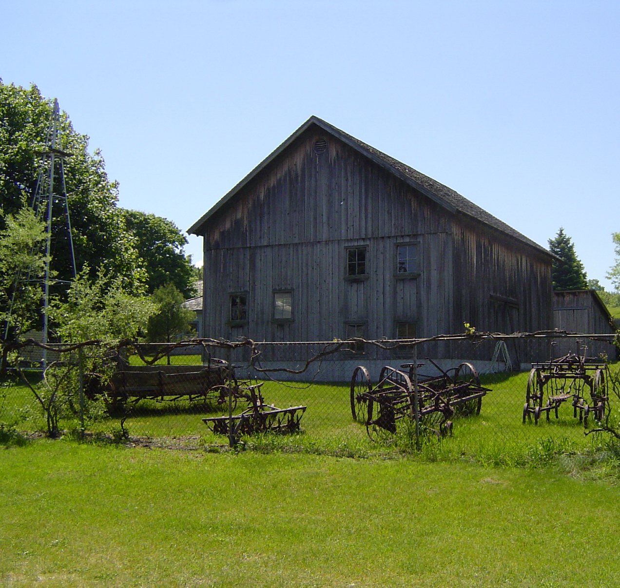
A typical
farmhouse of the area was generally of two stories with the bedrooms upstairs. [http://www.nps.gov/slbe/planyourvisit/farmbuildings.htm Farm Buildings Description] ] AMichigan Basement with thick stone walls can still be found at some of these farmhouses. They were used for storing canned goods. Later years furnaces and water heaters were put in the basement instead. Typicalouthouse s that were associated with the farmhouses can be found at the Thoreson and Dechow farms.There are several barns still existing in the district. The typical barn of the area had two stories and was used for cows and calves, especially in the winter months.
Corn crib s can be found at the Bufka, Burfiend, Dechow, Eitzen, and Thoreson farms. Agranary can still be found at the Thoreson, Dechow, and Bufka farms. Asugar house or sugar shack is at the Oechow farm on M22. Asilo can be found at the Olsen farm on M22. A cement stave silo is located at the Dechow farm and a tile silo is at the Eitzen farm. A milk house orspring house can be found at the Dechow farm and at the Thoreson Farm.Chicken coop s are still found at Dechow, Thoreson and the Lawr farms.Port Oneida Fair
The Port Oneida Fair takes place once a year on the second Friday and Saturday of August. [ [http://www.leelanau.com/fair/ Port Oneida Fair - Now the SECOND weekend in August....] ] [ [http://www.phsb.org/calendar/?id=82 Annual Port Oneida Fair Tells Story of Rural Culture] ] [ [http://www.sleepingbeardunes.com/info/area_pofair.php Sleeping Bear Dunes Visitor's Bureau - Area Festivals] ] It displays crafts and skills by representing rural life as it happened during the 1800s and early 1900s. At the Dechow farm they show many demonstrations typical of nineteenth century farming techniques. While the Fair is free, a Park Pass [ [http://www.nps.gov/fees_passes.htm America the Beautiful - National Parks and Federal Recreational Lands Pass] ] is required. [http://www.leelanau.com/fair/ A Celebration of Rural Culture & Arts] ]
References
* Noble, Allen George, "The Old Barn Book, A Field Guide to North American Barns and Other Farm Structures," Rutgers University Press, 1996. ISBN-13: 9780813521732
* Sloane, Eric, "An Age of Barns", Natural History Books; Des Moines, Iowa, 1976; ISBN 9780896585652
* McNaney, Marla J., "Farming at the Water's Edge," Midwest Region Office, National Park Service, Omaha, NE, 1995. History of the Port Oneida area.Notes
Wikimedia Foundation. 2010.