- Westerbork (village)
Dutch town locator maps
mun_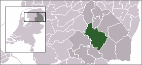
town_
caption = The town centre (dark green) and the statistical district (light green) of Westerbork in the municipality of Midden-Drenthe.Westerbork is a town in the Dutch province of
Drenthe . It is a part of the municipality ofMidden-Drenthe .The village gives its name to the
Westerbork deportation and later,concentration camp , located about 7 km north of the village, in the forests of Hooghalen.The
Westerbork Synthesis Radio Telescope (WSRT) array was installed near the site of the camp in1969 .Westerbork was a separate municipality until 1998, when it became part of
Middenveld . [Ad van der Meer and Onno Boonstra, "Repertorium van Nederlandse gemeenten", KNAW, 2006. [http://www.knaw.nl/cfdata/publicaties/detail.cfm?boeken__ordernr=20061061] ]In 2001, the town of Westerbork had 4075 inhabitants. The built-up area of the town was 1.8 km², and contained 1794 residences.Statistics Netherlands (CBS), [http://www.cbs.nl/nl-NL/menu/themas/milieu-natuur-ruimte/ruimte/publicaties/cartografie-geografie/geografische-data/2001-bevolkingskernen-in-nederland.htm "Bevolkingskernen in Nederland 2001"] . (Statistics are for the continuous built-up area).] The statistical area "Westerbork", which also can include the surrounding countryside, has a population of around 4710.Statistics Netherlands (CBS), [http://statline.cbs.nl/ "Statline: Kerncijfers wijken en buurten 2003-2005"] . As of
January 1 ,2005 .]References
External links
* [http://www.kuijsten.de/atlas/dr/westerbork.html Map of the former municipality in 1868]
Wikimedia Foundation. 2010.