- Kent
-
"County of Kent" redirects here. For other uses, see Kent County (disambiguation).For other uses, see Kent (disambiguation).
Kent 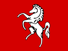
InvictaMotto of County Council: ''Invicta'' 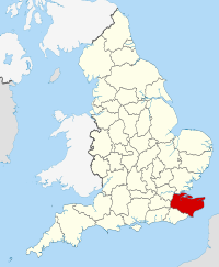
Geography Status Ceremonial and (smaller) Non-metropolitan county Region South East England Area
- Total
- Admin. council
- Admin. areaRanked 10th
3,736 km2 (1,442 sq mi)
Ranked 10th
3,544 km2 (1,368 sq mi)Admin HQ Maidstone ISO 3166-2 GB-KEN ONS code 29 NUTS 3 UKJ42 Demography Population
- Total (2010 est.)
- Density
- Admin. council
- Admin. pop.Ranked 7th
1,684,200
451 /km2 (1,170 /sq mi)
Ranked 1st
1,427,500Ethnicity 96.9% White
1.9% AsianPolitics 
"CANTIA"
Kent County Council
http://www.kent.gov.uk/
Medway Council
http://www.medway.gov.uk/Executive Conservative Members of Parliament - Julian Brazier (C)
- Rehman Chishti (C)
- Greg Clark (C)
- Damian Collins (C)
- Tracey Crouch (C)
- Charlie Elphicke (C)
- Michael Fallon (C)
- Roger Gale (C)
- Helen Grant (C)
- Damian Green (C)
- Gordon Henderson (C)
- Adam Holloway (C)
- Gareth Johnson (C)
- Mark Reckless (C)
- Hugh Robertson (C)
- Laura Sandys (C)
- John Stanley (C)
Districts 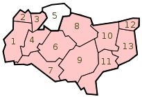
Kent /ˈkɛnt/ is a county in southeast England, and is one of the home counties. It borders East Sussex, Surrey and Greater London and has a defined boundary with Essex in the middle of the Thames Estuary. The ceremonial county boundaries of Kent include the shire county of Kent and the unitary borough of Medway. Kent has a nominal border with France halfway through the Channel Tunnel. Maidstone is its county town and historically Rochester and Canterbury have been accorded city status, though only the latter still holds it.
Kent's location between London and the continental Europe has led to its being in the front line of several conflicts, including the Battle of Britain during World War II. East Kent was named Hell Fire Corner during the conflict. England has relied on the county's ports to provide warships through much of the past 800 years; the Cinque Ports in the 12th–14th centuries and Chatham Dockyard in the 16th–20th centuries were of particular importance to the country's security. France can be seen clearly in fine weather from Folkestone, and the iconic White Cliffs of Dover.
Because of its abundance of orchards and hop gardens, Kent is widely known as "The Garden of England" – a name often applied when marketing the county or its produce, although other regions have tried to lay claim to the title.[1][2] Major industries in the north-west of Kent have included cement, papermaking, and aircraft construction, but these are now in decline. Large parts of Kent are within the London commuter belt. South and East Kent rely on tourism and agriculture. Coal mining has also played its part in Kent's industrial heritage.
Contents
History
Main article: History of KentThe area has been occupied since the Palaeolithic era, as attested by finds from the quarries at Swanscombe. The Medway megaliths were built during the Neolithic era. There is a rich sequence of Bronze Age, Iron Age, and Roman era occupation, as indicated by finds and features such as the Ringlemere gold cup and the Roman villas of the Darent valley.[3]
The modern name of Kent is derived from the Brythonic word Cantus meaning "rim" or "border". This describes the eastern part of the current county area as a border land or coastal district. Julius Caesar had described the area as Cantium, or home of the Cantiaci in 51 BC.[4]
The extreme west of the modern county was occupied by Iron Age tribes, known as the Regnenses. It is possible that another ethnic group occupied what is now called The Weald and East Kent. East Kent became a kingdom of the Jutes during the 5th century[5] and was known as Cantia from about 730 and as Cent in 835. The early medieval inhabitants of the county were known as the Cantwara, or Kent people. These people regarded the city of Canterbury as their capital.[6]
In 597, Pope Gregory I appointed Augustine as the first Archbishop of Canterbury. In the previous year, Augustine successfully converted the pagan King Æthelberht of Kent to Christianity. The Diocese of Canterbury became Britain's first Episcopal See and has since remained Britain's centre of Christianity.[7]
In the 11th century, the people of Kent adopted the motto Invicta, meaning "undefeated". This naming followed the invasion of Britain by William of Normandy. The Kent people's continued resistance against the Normans led to Kent's designation as a semi-autonomous County Palatine in 1067. Under the nominal rule of William's half-brother Odo of Bayeux, the county was granted similar powers to those granted in the areas bordering Wales and Scotland.[8]
During the medieval and early modern period, Kent played a major role in several of England's most notable rebellions, including the Peasants' Revolt of 1381, led by Wat Tyler,[9] Jack Cade's Kent rebellion of 1450, and Wyatt's Rebellion of 1554 against Queen Mary I.[10]
 Titlepage of William Lambard's Perambulation of Kent, being a history of the county of Kent since William the Conqueror.
The Royal Navy first used the River Medway in 1547. By the reign of Elizabeth I (1558–1603) a small dockyard had been established at Chatham. By 1618, storehouses, a ropewalk, a drydock, and houses for officials had been built downstream from Chatham.[11]
By the 17th century, tensions between Britain and the powers of the Netherlands and France led to increasing military build-up in the county. Forts were built all along the coast following the raid on the Medway, a successful attack by the Dutch navy on the shipyards of the Medway towns in 1667.[12]
The 18th century was dominated by wars with France, during which the Medway became the primary base for a fleet that could act along the Dutch and French coasts. When the theatre of operation moved to the Atlantic, this role was assumed by Portsmouth and Plymouth, with Chatham concentrating on shipbuilding and ship repair. As an indication of the area's military importance, the first Ordnance Survey map ever drawn was a one-inch map of Kent, published in 1801.[13] Many of the Georgian naval buildings still stand.
In the early 19th century, smugglers were very active on the Kent coastline. Gangs such as The Aldington Gang brought spirits, tobacco and salt to the county, and transported goods such as wool across the sea to France.[14]
In 1889, the County of London was created and the townships of Deptford, Greenwich, Woolwich, Lee, Eltham, Charlton, Kidbrooke and Lewisham were transferred out of Kent and in 1900 the area of Penge was gained. Some of Kent, notably Dartford, is contiguous with Greater London.
During World War II, much of the Battle of Britain was fought in the skies over the county. Between June 1944 and March 1945, over 10,000 V1 flying bombs, known as "Doodlebugs", were fired on London from bases in Northern France. Many were destroyed by aircraft, anti-aircraft guns, and barrage balloons, yet both London and Kent were hit by around 2,500 of these bombs.
After the war, Kent's borders changed several more times. In 1965 the London boroughs of Bromley and Bexley were created from nine towns formerly in Kent.[15][16] In 1998, Rochester, Chatham, Gillingham, and Rainham left the administrative county of Kent to form the Unitary Authority of Medway. During this reorganisation, through an "apparent" administrative oversight, the city of Rochester lost its official city status.[17]
Climate
Kent is one of the warmest parts of Britain. On 10 August 2003, in the hamlet of Brogdale near Faversham the temperature reached 38.5 °C (101.3 °F), the hottest temperature ever recorded in the United Kingdom.[18]
Here is a climate chart for Wye near Ashford.
Climate data for Wye, England (1971–2000) data Month Jan Feb Mar Apr May Jun Jul Aug Sep Oct Nov Dec Year Average high °C (°F) 7.1
(44.8)7.2
(45.0)9.9
(49.8)12.1
(53.8)15.9
(60.6)18.7
(65.7)21.3
(70.3)21.6
(70.9)18.4
(65.1)14.5
(58.1)10.3
(50.5)8.0
(46.4)13.8 Daily mean °C (°F) 4.3
(39.7)4.3
(39.7)6.4
(43.5)8.2
(46.8)11.6
(52.9)14.3
(57.7)16.8
(62.2)16.9
(62.4)14.3
(57.7)10.9
(51.6)7.1
(44.8)5.3
(41.5)10.1 Average low °C (°F) 1.5
(34.7)1.3
(34.3)2.8
(37.0)4.3
(39.7)7.3
(45.1)9.9
(49.8)12.2
(54.0)12.2
(54.0)10.1
(50.2)7.2
(45.0)3.9
(39.0)2.6
(36.7)6.3 Precipitation mm (inches) 72.0
(2.835)44.7
(1.76)53.5
(2.106)50.8
(2)45.3
(1.783)51.8
(2.039)47.1
(1.854)55.9
(2.201)65.3
(2.571)85.4
(3.362)78.7
(3.098)77.3
(3.043)727.9
(28.657)Avg. rainy days 12.6 9.3 10.0 9.1 8.9 8.6 6.8 7.2 8.7 11.3 11.6 12.0 116.1 Sunshine hours 55.2 74.3 112.2 159.3 205.5 196.5 203.1 209.3 148.8 117.5 72.6 49.0 1,603.2 Source: [1] Physical geography
Main article: Geography of Kent 'The White Cliffs of Dover'
Kent is in the southeastern corner of England. It borders the River Thames and the North Sea to the north, and the Straits of Dover and the English Channel to the south. France is 34 kilometres (21 mi) across the Strait.[19]
The major geographical features of the county are determined by a series of ridges and valleys running east-west across the county. These are the results of erosion of the Wealden dome, a dome across Kent and Sussex created by Alpine movements 10–20 million years ago. This dome consists of an upper layer of Chalk above successive layers of Upper Greensand, Gault Clay, Lower Greensand, Weald Clay, and Wealden sandstone. The ridges and valleys formed when the exposed clay eroded faster than the exposed chalk, greensand, or sandstone.
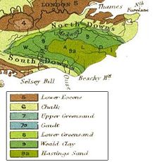 Geological map of southeast England, showing a concentric circular pattern formed by the weathering of the Wealden dome.
Sevenoaks, Maidstone, Ashford, and Folkestone are built on greensand,[20] while Tonbridge and Tunbridge Wells are built on sandstone.[21] Dartford, Gravesend, the Medway towns, Sittingbourne, Faversham, Canterbury, Deal, and Dover are built on chalk.[20][21] The easterly section of the Wealden dome has been eroded away by the sea, and cliffs such as the white cliffs of Dover are present where a chalk ridge known as the North Downs meets the coast. Spanning Dover and Westerham is the Kent Downs Area of Outstanding Natural Beauty.[22]
The Wealden dome is a Mesozoic structure lying on a Palaeozoic foundation, which can often create the right conditions for coal formation. This is found in East Kent roughly between Deal, Canterbury, and Dover. The Coal Measures within the Westphalian Sandstone are deep about 250 m – 400 m (800 – 1300 ft) and subject to flooding. They occur in two major troughs, which extend under the English Channel where similar coalfields are located.[23]
Seismic activity has occasionally been recorded in Kent, though the epicentres were offshore. In 1382 and 1580 there were two earthquakes exceeding 6.0 on the Richter Scale. In 1776, 1950, and on 28 April 2007 there were earthquakes of around 4.3. The 2007 earthquake caused physical damage in Folkestone.[24]
 Geological cross section of Kent, showing how it relates to major towns
The coastline of Kent is continuously changing, due to tectonic uplift and coastal erosion. Until about 960, the Isle of Thanet was an island, separated by the Wantsum channel, formed around a deposit of chalk; over time, the channels silted up with alluvium. Similarly Romney Marsh and Dungeness have been formed by accumulation of alluvium.[21]
Kent's principal river, the River Medway, rises near East Grinstead in Sussex and flows eastwards to Maidstone. Here it turns north and breaks through the North Downs at Rochester, then joins the estuary of the River Thames as its final tributary near Sheerness. The Medway is some 112 kilometres (70 mi) long.[25][26] The river is tidal as far as Allington lock, but in earlier times, cargo-carrying vessels reached as far upstream as Tonbridge.[25] The Medway has captured the head waters of other rivers such as the River Darent. Other rivers of Kent include the River Stour in the east.
Demographics
Kent Compared 2001 UK census Kent South East England England Total population 1,579,206 8,000,645 49,138,831 Foreign born 5.8% 8.1% 9.2% White 96.5% 95.1% 90.9% Asian 2.0% 2.7% 4.6% Black 0.4% 0.7% 2.3% Christian 74.6% 72.8% 72% Muslim 0.6% 1.4% 3.1% Sikh 0.7% 0.5% 0.7% As of the 2001 UK census,[27] Kent, including Medway, had 1,579,206 residents and 646,308 households, of which 1,329,718 residents and 546,742 households were within the administrative boundaries. Of those households, 48.9% were married couples living together, 9.0% were co-habiting couples and 8.7% were lone parents; 28.0% of households consisted of individuals, 14.6% had someone of pensionable age living alone, and 30.4% included children aged under 16 or a person aged 16 to 18 who was in full-time education. For every 100 females, there were 93.9 males.
The ethnicity of Kent was 96.5% White, 0.9% mixed race, 0.3% Chinese, 1.7% other Asian and 0.4% Black. The place of birth for residents was 94.2% United Kingdom, 0.7% Republic of Ireland, 0.5% Germany, 0.9% other Western Europe countries, 0.3% Eastern Europe, 0.8% Africa, 0.6% Far East, 0.9% South Asia, 0.2% Middle East, 0.4% North America, 0.1% South America and 0.3% Oceania. Religion was recorded as 74.6% Christian, 0.7% Sikh, 0.6% Muslim, 0.4% Hindu, 0.2% Buddhist and 0.1% Jewish, while 15.2% were recorded as having no religion, 0.3% had an alternative religion, and 7.8% did not state their religion.
Government
Kent County Council (KCC) and its 12 district councils administer most of the county (3352 km²), while the Medway Towns Council, a unitary authority and commonly called Medway Council, administers the more densely populated remainder (192 km²).[28] Together they have around 300 town and parish councils. Kent County Council's headquarters are in Maidstone,[29] while Medway's offices are at Gun Wharf, Chatham.
As of the 2009 county council elections, Kent County Council was controlled by the Conservatives, which won 74 of the Council's 84 seats, 7 were won by the Liberal Democrats, 2 by the Labour Party and 1 by the Swanscombe and Greenhithe Residents Association. As of the 2007 local elections, Medway Council was controlled by the Conservatives; 33 of the Council's 55 seats were held by the Conservatives, 13 by the Labour Party, 8 by the Liberal Democrats and 1 by an Independent.[30] Currently, all of Kent's district councils are controlled by the Conservatives; the only British county that is in this position.
At the national level, Kent is represented in Parliament by 17 MPs, all of whom are Conservative. Kent is in the European Parliament constituency of South East England, which elects ten members of the European Parliament.[31]
Economy
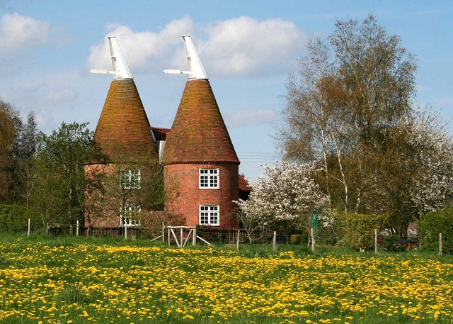
 Converted oast at Frittenden.
As of the 2001 UK census,[27] employment statistics for the residents in Kent, including Medway, were as follows: 41.1% in full-time employment, 12.4% in part-time employment, 9.1% self-employed, 2.9% unemployed, 2.3% students with jobs, 3.7% students without jobs, 12.3% retired, 7.3% looking after home or family, 4.3% permanently sick or disabled, and 2.7% economically inactive for other reasons. Of residents aged 16–74, 16% had a higher education qualification or the equivalent, compared to 20% nationwide.[27]
The average hours worked per week by residents of Kent were 43.1 for males and 30.9 for females. Their industry of employment was 17.3% retail, 12.4% manufacturing, 11.8% real estate, 10.3% health and social work, 8.9% construction, 8.2% transport and communications, 7.9% education, 6.0% public administration and defence, 5.6% finance, 4.8% other community and personal service activities, 4.1% hotels and restaurants, 1.6% agriculture, 0.8% energy and water supply, 0.2% mining, and 0.1% private households. This is higher than the whole of England for construction and transport/communications, and lower for manufacturing.
Kent is sometimes known as the "Garden of England" for its abundance of orchards and hop gardens. Distinctive hop-drying buildings called oasts are common in the countryside, although many have been converted into dwellings. Nearer to London, market gardens also flourish.
However, in recent years, there has been a significant drop in agriculture, and industry and services are increasing their utilisation of the area. This is illustrated by the following table of economic indicator gross value added (GVA) between 1995 and 2000 (figures are in millions of British Pounds Sterling).[32]
Year Regional GVA[A] Agriculture Industry[B] Services[C] County of Kent (excluding Medway) 1995 12,369 379 3.1% 3,886 31.4% 8,104 65.5% 2000 15,259 259 1.7% 4,601 30.2% 10,399 68.1% 2003 18,126 287 1.6% 5,057 27.9% 12,783 70.5% Medway 1995 1,823 21 3.1% 560 31.4% 1,243 68.2% 2000 2,348 8 1.7% 745 30.2% 1,595 67.9% 2003 2,671 10 1.6% 802 27.9% 1,859 69.6% A Components may not sum to totals due to rounding B includes energy and construction C includes financial intermediation services indirectly measured North Kent is heavily industrialised with cement-making at Northfleet and Cuxton, brickmaking at Sittingbourne, shipbuilding on the Medway and Swale, engineering and aircraft design and construction at Rochester, chemicals at Dartford and papermaking at Swanley, and oil refining at Grain.[15] A steel mini mill in Sheerness and a rolling mill in Queenborough.There are two nuclear power stations at Dungeness, although the older one, built in 1965, was closed at the end of 2006.[33]
Cement-making, papermaking, and coal-mining were important industries in Kent during the 19th and 20th century. Cement came to the fore in the 19th century when massive building projects were undertaken. The ready supply of chalk and huge pits between Stone and Gravesend bear testament to that industry. There were also other workings around Burham on the tidal Medway.[34]
Kent's original paper mills stood on streams like the River Darent, tributaries of the River Medway, and on the River Stour. Two 18th century mills were on the River Len and at Tovil on the River Loose. In the late 19th century huge modern mills were built at Dartford and Northfleet on the River Thames and at Kemsley on The Swale. In pre-industrial times, almost every village and town had its own windmill or watermill, with over 400 windmills known to have stood at some time. Twenty eight survive within the county today, plus two replica mills and a further two in that part of Kent now absorbed into London. All the major rivers in the county were used to power watermills.
From about 1900, several coal pits operated in East Kent. The Kent Coalfield was mined during the 20th century at several collieries,[35] including Chislet, Tilmanstone, Betteshanger, and the Snowdown Colliery, which ran from 1908 to 1986.[36]
The west of the county (including Maidstone, Tunbridge Wells & Sevenoaks) is generally more affluent than the east, especially when compared to the coastal regions of Folkestone, Dover & Thanet. This is partly due to the former's proximity to London, making it prime "commuter belt" and the latter's geographic extremities. The eagerly awaited CTRL 2009 rail service, using the high speed Channel Tunnel line to bring coastal areas' travel times to London down to around an hour, is hoped to further regeneration.
Arts
Kent has provided inspiration for several notable writers and artists. Canterbury's religious role gave rise to Chaucer's Canterbury Tales, a key development in the English language. The father of novelist Charles Dickens worked at the Chatham Dockyard; in many of his books, the celebrated novelist featured the scenery of Chatham, Rochester, and the Cliffe marshes.[37] The landscape painter J. M. W. Turner spent part of his childhood in the town of Margate in East Kent, and regularly returned to visit it throughout his life. The East Kent coast inspired many of his works, including some of his most famous seascapes.[38] During the late 1930s, Nobel Prize-awarded novelist William Golding worked as a teacher at Maidstone Grammar School, where he met his future wife Ann Brookfield.[39]
The county's largest theatre is The Marlowe Theatre, situated in the centre of Canterbury. It is currently being redeveloped to re-open in October 2011.
Transport
Main article: Transport in KentRoads
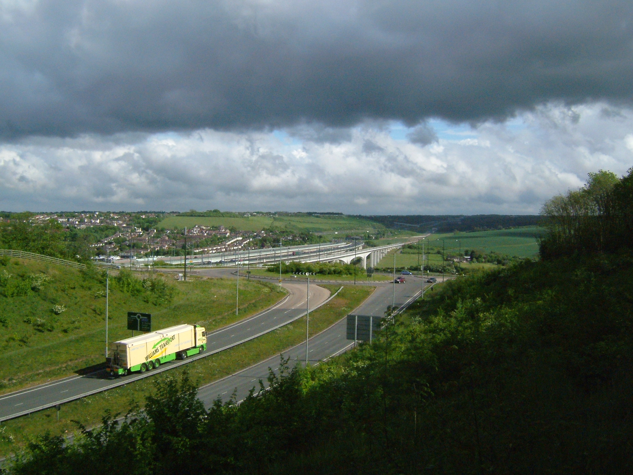
 The M2 and High Speed 1 crossing the Medway Valley, south of Rochester.
With the Roman invasion, a road network was constructed to connect London to the Channel ports of Dover, Lympne and Richborough. The London–Dover road was Watling Street. These roads are now approximately the A2, B2068, A257, and the A28. The A2 runs through Dartford (A207), Gravesend, Rochester, Canterbury and Dover; the A20 through Eltham, Wrotham, Maidstone, Charing, Ashford. Hythe, Folkestone and Dover; the A21 around Sevenoaks, Tonbridge, Tunbridge Wells and on to Hastings in East Sussex.[15] In the 1960s, two motorways were built; the M2 from Medway to Faversham, and the M20 from Swanley to Folkestone. Part of the M25 runs through Kent, from Westerham to the Kent and Essex tunnel at Dartford. The Dartford tunnel has been joined by the Queen Elizabeth II Bridge, together providing four lanes in each direction. The M26 motorway, built in 1980, provides a short link between the M25 at Sevenoaks and the M20 near Wrotham. Kent currently has more motorways by distance than any other county in the UK, with sections of the M2, M20, M25 and M26 totalling 173 km within the extents of the ceremonial county.
Water
The medieval Cinque Ports, except for Dover, have all now silted up. The Medway Estuary has been an important port and naval base for 500 years. The River Medway is tidal up to Allington and navigable up to Tonbridge. Kent's two canals are the Royal Military Canal between Hythe and Rye, which still exists, and the Thames and Medway Canal between Strood and Gravesend. Built in 1824, it was purchased in 1846 by the railways, which partially backfilled it.[15] Container ports are located at Ramsgate and Thamesport.
Railways

The earliest locomotive-driven passenger-carrying railway in Britain was the Canterbury and Whitstable Railway which opened in 1830.[40] This and the London and Greenwich Railway later merged into South Eastern Railway (SER).[41] By the 1850s, SER's networks had expanded to Ashford, Ramsgate, Canterbury, Tunbridge Wells, and the Medway towns. SER's major London termini were London Bridge, Charing Cross, and Cannon Street. Kent also had a second major railway, the London, Chatham and Dover Railway (LCDR). Originally the East Kent Railway in 1858, it linked the northeast Kent coast with London terminals at Victoria and Blackfriars.
The two companies merged in 1899, forming the South Eastern and Chatham Railway (SECR). In the aftermath of World War I, the government's Railways Act 1921 grouped railway companies together; the SECR joined neighbouring London, Brighton and South Coast Railway (LBSCR) and London and South Western Railway (LSWR) to form the Southern Railway.[41] Britain's railways were nationalised in 1948, forming British Rail. The railways were privatised in 1996 and most Kent passenger services were franchised to Connex South Eastern.[42] Following financial difficulties, Connex lost the franchise and was replaced by South Eastern Trains and after Southeastern.[43]
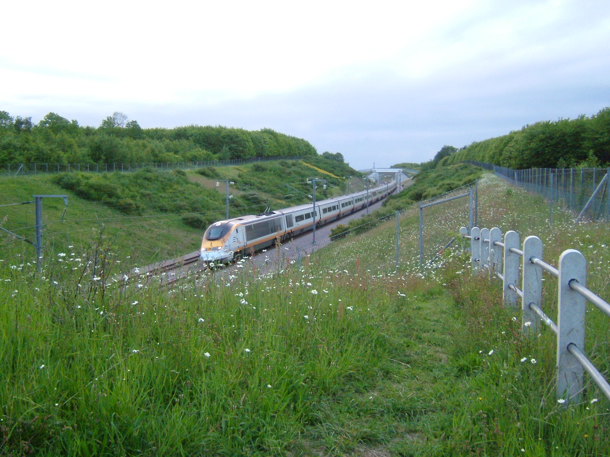
The Channel Tunnel was completed in 1994 and High Speed 1 in November 2007 with a London terminus at St Pancras. A new station, Ebbsfleet International, opened between Dartford and Gravesend, serving northern Kent.[44] The high speed lines will be utilised to provide a faster train service to coastal towns like Ramsgate and Folkestone. This station is in addition to the existing station at Ashford International, which has suffered a massive cut in service as a result.
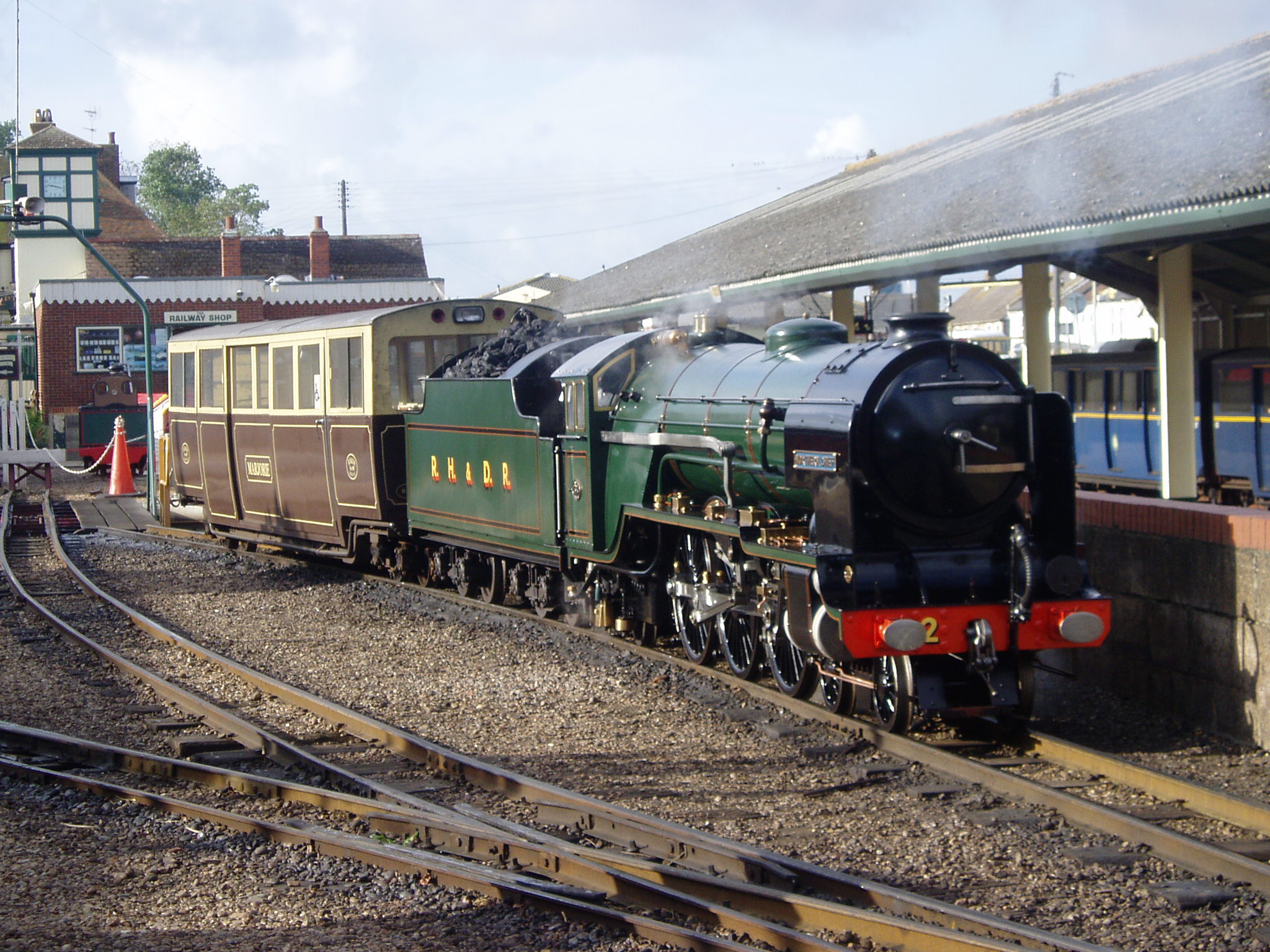
 Romney, Hythe and Dymchurch Railway
In addition to the "mainline" railways, there are several light, heritage, and industrial railways in Kent. There are three heritage, standard gauge railways; Spa Valley Railway near Tunbridge Wells on the old Tunbridge Wells West branch, East Kent Railway on the old East Kent coalfield area and the Kent and East Sussex Railway on the Weald around Tenterden. In addition there is the 15-inch (380 mm) gauge, tourist-oriented Romney, Hythe and Dymchurch Railway on the southeast Kent coast along the Dungeness peninsula. Finally, there is the 2 ft 6 in (0.76 m), industrial Sittingbourne & Kemsley Light Railway.
Air
A limited number of charter flights are provided by Kent's Kent International Airport at Manston, and London Ashford Airport at Lydd. However, most passengers across the South East use the larger Heathrow, Gatwick, Stansted and Luton airports. In 2002, it was revealed that the government was considering building a new four-runway airport on the marshland near the village of Cliffe on the Hoo Peninsula.[45] This plan was dropped in 2003 following protests by cultural and environmental groups.[46]
Education
See also: List of schools in KentThe county has three universities; Canterbury Christ Church University with campuses throughout East Kent, University of Kent, with campuses in Canterbury and Medway, and University of Greenwich (a London University), with sites at Woolwich, Eltham, London and Medway. The University of Creative Arts (UCA) also has three of its five campuses in the county.
Whereas much of Britain adopted a comprehensive education system in the 1970s, Kent County Council (KCC) and Medway Unitary Authority are among around fifteen[47] local authorities still providing wholly selective education through the eleven-plus examination with students allocated a place at a secondary modern school or at a grammar school. Together, the two Kent authorities have 38 of the 164 grammar schools remaining in Britain.[47][48]
KCC has the largest education department of any local authority in Britain,[49] providing school places for over 289,000 pupils.
Schools in Kent (data from 2000)[50] LEA Nursery Primary Secondary
(modern)Secondary
(Grammar)Special Pupil
Referral
UnitsIndependent City
Technology
CollegeTotal KCC 1 475 74 32 34 11 83 1 711 Medway 0 89 14 6 3 1 7 0 120 For the 2005–06 school year, KCC and Medway introduced a standardised school year, based on six terms, as recommended by the Local Government Association in its 2000 report, "The Rhythms of Schooling".[51]
Kent County Council LEA maintains 96 secondary schools, of which 33 are selective schools and 63 are secondary modern schools.
National Challenge schools
Kent has the highest number of National Challenge schools in England, schools which are branded "failing" based on the British Government's floor targets that 30% of pupils achieve at least 5 GCSE grades A* to C.[52] Of the 63 secondary modern schools, 33 achieved below this requirement meaning that 52% of Kent secondary modern schools (34% out of all 96 maintained secondary schools) are failing.[53]
Local media
Television
Much of Kent is served by the BBC's South East region, which is based in Tunbridge Wells and provides local news for the county and East Sussex. Its commercial rival is ITV Meridian Ltd, which has a newsroom at The Maidstone Studios despite the main studio being based in Hampshire. Main transmitters providing these services are located at West Hougham, near Dover and Bluebell Hill, located between Chatham and Maidstone. Those parts of Kent closer to London such as Gravesend, Dartford and parts of Sevenoaks lie within the ITV London and BBC London areas, taking their television signals from the Crystal Palace transmitter.
The county is also served by two internet-based TV channels, Kent TV (part-owned by Kent County Council) and YourKentTV which is owned by KOS Media.
Radio
Kent has three county-wide stations – BBC Radio Kent, based in Tunbridge Wells; and the commercial stations Heart and Gold, both based in Whitstable and London.
Most of the county is covered by local radio network KMFM, owned by the KM Group. Other than the breakfast show, programmes are the same across all seven stations in the network:
- KMFM Ashford
- KMFM Canterbury
- KMFM Maidstone
- KMFM Medway
- KMFM Shepway and White Cliffs Country
- KMFM Thanet
- KMFM West Kent
The county has five community radio stations.
- BRFM covers the Isle of Sheppey
- SFM covers Sittingbourne
- CSR 97.4FM covers Canterbury, as a joint production between the city's two universities
- Academy FM (Thanet) covers Thanet
- Academy FM (Folkestone) covers Folkestone
A licence has been granted for Radio Sunlight in Gillingham, but no broadcast dates have yet been set.
Dover Community Radio (DCR) offers a podcasting service for the people of Dover district on their website, hoping in the future to apply for a community radio licence to cover the town and its environs.
Newspapers
The KM Group, KOS Media and Kent Regional News and Media all provide local newspapers for most of the large towns and cities. County-wide papers include the Kent Messenger, Kent on Saturday, Kent on Sunday, and the Kent and Sussex Courier.[citation needed]
See also
- Outline of England
- Duke of Kent
- High Sheriff of Kent
- List of civil parishes in Kent
- List of fire stations in Kent
- List of people from Kent
- List of places in Kent
- List of tourist attractions in Kent
- List of windmills in Kent
- Lord Lieutenant of Kent
- Recreational walks in Kent
- Thames Gateway – includes details of regeneration projects in the northern areas of Kent
- Thanet
- Category:Towns in Kent
- Category:Villages in Kent
References
- ^ Kent loses its Garden of England title to North Yorkshire. The Guardian 1 June 2006
- ^ Garden of England title defended, BBC. 1 June 2006
- ^ Ashbee, Paul (2005). Kent in prehistoric times. Tempus.
- ^ Glover, J.. Place names of Kent.
- ^ Witney, K. P. (1982). The Kingdom of Kent.
- ^ "Victoria County History of Kent". KentArchaeology.org.uk. May 2006. http://www.kentarchaeology.org.uk/Research/03/03/01C/064.htm. Retrieved 20 April 2007.
- ^ "Archbishop of Canterbury". Spartacus.SchoolNet.co.uk. http://www.spartacus.schoolnet.co.uk/NORarchcanterbury.htm. Retrieved 19 June 2007.
- ^ David Bates (1975). The Character and Career of Odo, Bishop of Bayeux (1049/50-1097). Speculum.
- ^ "Peasants' Revolt". Britannia.com. http://www.britannia.com/history/articles/peasantsrevolt.html. Retrieved 20 April 2007.
- ^ "Sir Thomas WYATT, "The Younger"". TudorPlace.com.ar. http://www.tudorplace.com.ar/Bios/ThomasWyatt(Sir)2.htm. Retrieved 20 April 2007.
- ^ The Historic Dockyard Chatham — where legends were created. Jarrold Publishing. 2005.
- ^ "The Dutch In The Medway". DeRuyter.org. http://www.deruyter.org/CHATHAM_Dutch_in_the_Medway.html. Retrieved 20 April 2007.
- ^ Oliver, Richard (1995). Ordnance Survey maps: a concise guide for historians 2nd Ed. Ordnance Survey. ISBN 1870598245.
- ^ "South-East England". Smuggler's Britain. http://www.smuggling.co.uk/gazetteer_se_14.html. Retrieved 20 April 2007.
- ^ a b c d Jessup, Frank W. (1966). Kent History Illustrated. Kent County Council.
- ^ "Medway". Communities and Local Government. http://www.communities.gov.uk/index.asp?id=1170128. Retrieved 20 April 2007.
- ^ "Error costs Rochester city status". BBC News. 16 May 2002. http://news.bbc.co.uk/1/hi/uk/england/1991827.stm. Retrieved 20 April 2007.
- ^ "UK Records". BBC Weather. http://www.bbc.co.uk/weather/features/understanding/uk_records.shtml. Retrieved 10 June 2009.
- ^ "English Channel". Microsoft Encarta Online Encyclopedia 2007. Archived from the original on 1 November 2009. http://www.webcitation.org/query?id=1257036635752931. Retrieved 20 April 2007.
- ^ a b Greensand Way in Kent. Kent Count Council. 1992. ISBN 1-873010-23-0.
- ^ a b c Britain's Structure and Scenery, L.Dudley Stamp, Pub September 1946, Collins New Naturalist Series.
- ^ "Kent Downs". KentDowns.org. http://www.kentdowns.org.uk/. Retrieved 20 April 2007.
- ^ "Geology of Kent and Boulonnais". The Geology Shop. 2000. http://www.geologyshop.co.uk/geolkb.htm. Retrieved 8 August 2009.
- ^ Hill, Amelia (29 April 2007). "Quake causes Kent Families to flee Homes". The Guardian (UK). http://observer.guardian.co.uk/uk_news/story/0,,2068090,00.html. Retrieved 28 April 2007.
- ^ a b Bowskill, Derek. Map Of The River Medway.
- ^ Environmental Agency: River Medway
- ^ a b c "Neighbourhood Statistics". Statistics.gov.uk. http://neighbourhood.statistics.gov.uk/dissemination/LeadHome.do;jsessionid=ac1f930bce6a711447e60ba4446bb56c21648d42c51.e38PbNqOa3qRe38OaNeKahqMai1ynknvrkLOlQzNp65In0?bhcp=1. Retrieved 29 March 2007.
- ^ Kent (Borough of Gillingham and City of Rochester upon Medway) (Structural Change) Order 1996 "Kent (Borough of Gillingham and City of Rochester upon Medway) (Structural Change) Order 1996". HMSO. http://www.uk-legislation.hmso.gov.uk/si/si1996/Uksi_19961876_en_1.htm. Retrieved 17 March 2010.
- ^ "Council and democracy". Kent County Council. Archived from the original on 6 February 2007. http://web.archive.org/web/20070206185542/http://www.kent.gov.uk/council-and-democracy/. Retrieved 19 April 2007.
- ^ "Democratically elected representatives in Medway". Medway Council. http://www.medway.gov.uk/index/council/councillor.htm. Retrieved 13 May 2007.
- ^ "UK MEPs". UK Office Of The European Parliament. Archived from the original on 20 March 2007. http://web.archive.org/web/20070320000145/http://www.europarl.org.uk/uk_meps/MembersMain.htm. Retrieved 3 April 2007.
- ^ "Regional Gross Value Added" (PDF). Office for National Statistics. http://www.statistics.gov.uk/downloads/theme_economy/RegionalGVA.pdf. Retrieved 3 April 2007.
- ^ "Closure of Dungeness Power Station". BBC News. 31 December 2006. http://news.bbc.co.uk/1/hi/england/kent/6203953.stm. Retrieved 3 April 2007.
- ^ "The Chatham News Index" (PDF). Parret & Neves. 1996. http://www.gparrett.btinternet.co.uk/chatnews/cnidx_r2.pdf. Retrieved 19 April 2007.
- ^ "Coal fields Heritage Initiative". Dover Museum. http://www.dover.gov.uk/kentcoal/intro.asp. Retrieved 20 April 2007.
- ^ "Snowdown Colliery". FreeUK.com. http://home.freeuk.com/eastkent/mining/snowdown_colliery.htm. Retrieved 19 April 2007.
- ^ "Charles Dickens". InfoBritain. http://www.infobritain.co.uk/Charles_Dickens.htm. Retrieved 20 April 2007.
- ^ "The Turner Connection". TurnerContemporary.org. http://www.turnercontemporary.org/about/?p=15. Retrieved 20 June 2007.
- ^ "William Golding — Biography". William-Golding.co.uk. Archived from the original on 17 March 2007. http://web.archive.org/web/20070317193534/http://www.william-golding.co.uk/p_biography.html. Retrieved 20 June 2007.
- ^ "The lost railway". BBC. http://www.bbc.co.uk/kent/content/articles/2008/05/27/history_lost_railway_feature.shtml. Retrieved 1 August 2008.
- ^ a b "History of the South Eastern & Chatham Railway". The South Eastern & Chatham Railway Society. Archived from the original on 1 November 2006. http://web.archive.org/web/20061101091806/http://www.southeasternandchathamrailway.org.uk/webpages/History.htm. Retrieved 22 April 2007.
- ^ "Failed rail franchise 'needed time'". BBC. 13 November 2003. http://news.bbc.co.uk/1/hi/england/3268719.stm. Retrieved 13 May 2007.
- ^ "Rail workers vote to hold strikes". BBC. 13 April 2006. http://news.bbc.co.uk/1/hi/england/4905966.stm. Retrieved 13 May 2007.
- ^ "New station means Eurostar change". BBC. 12 September 2006. http://news.bbc.co.uk/1/hi/england/kent/5337586.stm. Retrieved 22 April 2007.
- ^ Davis, Matthew (12 September 2006). "Airport plan threatens Dickens' legacy". BBC. http://news.bbc.co.uk/1/hi/uk/2093415.stm. Retrieved 20 June 2007.
- ^ Feature, Advertisement (23 March 2008). "Saving nature". The Times (UK). http://www.timesonline.co.uk/tol/life_and_style/related_features/love_nature/article3625154.ece. Retrieved 6 September 2009.
- ^ a b Garner, Richard (20 January 2007). "Call for end to selective education as 'grammar school areas' fail". The Independent (UK). http://education.independent.co.uk/news/article2169188.ece. Retrieved 14 May 2007.
- ^ "Grammar schools have expanded". BBC News. 26 March 2004. http://news.bbc.co.uk/1/hi/education/3571387.stm. Retrieved 3 April 2007.
- ^ "Kent's selective schools compared". BBC News. 17 January 2003. http://news.bbc.co.uk/1/hi/education/2666605.stm. Retrieved 13 May 2007.
- ^ "Department for Education and Skills". Department for Education and Skills. http://www.dfes.gov.uk/. Retrieved 13 May 2007.
- ^ "Kent County Council". Kent County Council. http://www.kent.gov.uk/. Retrieved 3 April 2007.
- ^ "Brown threatens 'failing' schools". BBC News. 31 October 2007. http://news.bbc.co.uk/1/hi/education/7070190.stm. Retrieved 4 April 2010.
- ^ http://www.dcsf.gov.uk/nationalchallenge/downloads/DataSheet.pdf
External links
- Kent at the Open Directory Project
- Kent Parishes – Forum for History, Genealogy, Ancestry and local information
- Kent County Council – local government website
- Kent Wildlife Trust – Kent Wildlife Trust is the most active conservation trust in the county
- Kent Online – a Kent Messenger Group website
- Camelot Village – Kent heritage
- Kent Downs – Area of Outstanding Natural Beauty website
- CPRE Kent- Kent Branch of the Campaign to Protect Rural England (CPRE)
- historic-kent.co.uk – further information on villages throughout Kent.
- BBC – origins of Kent placenames
- Kent Coast in Pictures – photographs of the coastline of Kent.
- Kent County Cricket Club
- Official Kent Tourism Guide
- Official Heart of Kent Tourism Guide
- BBC feature on the Kent eleven-plus
- Kent-Weather – A county-wide weather forecasting website.
Neighbouring English counties and French department 
Greater London Essex Thames Estuary Surrey 
North Sea  Kent
Kent 

West Sussex East Sussex English Channel
Pas de Calais, FranceCeremonial county of Kent Kent Portal Unitary authorities Boroughs or districts Major settlements Ashford, Broadstairs, Canterbury, Chatham, Cranbrook, Dartford, Deal, Dover, Edenbridge, Faversham, Folkestone, Fordwich, Gillingham, Gravesend, Greenhithe, Herne Bay, Hythe, Lydd, Maidstone, Margate, Minster, New Romney, Northfleet, Paddock Wood, Queenborough, Rainham, Ramsgate, Rochester, Royal Tunbridge Wells, Sandwich, Sevenoaks, Sheerness, Sittingbourne, Snodland, Southborough, Strood, Swanley, Swanscombe, Tenterden, Tonbridge, Walmer, West Malling, Westerham, Westgate-on-Sea, Whitstable
See also: List of civil parishes in KentRivers See: Rivers of KentTopics Categories:- Anglo-Saxon England
- Kent
- Non-metropolitan counties
- South East England


Wikimedia Foundation. 2010.