- Kingston/Norman Rogers Airport
-
Kingston Airport 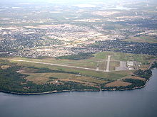
IATA: YGK – ICAO: CYGK
– WMO: 71620Summary Airport type Public Operator City of Kingston Location Kingston, Ontario Elevation AMSL 303 ft / 92 m Coordinates 44°13′33″N 076°35′48″W / 44.22583°N 76.59667°WCoordinates: 44°13′33″N 076°35′48″W / 44.22583°N 76.59667°W Website Map Location in Ontario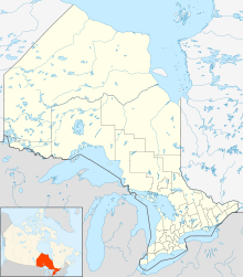
 CYGK
CYGKRunways Direction Length Surface ft m 01/19 4,929 1,502 Asphalt 07/25 3,909 1,191 Asphalt Statistics (2010) Aircraft movements 37,876 Source: Canada Flight Supplement[1]
Environment Canada[2]
Movements from Statistics Canada[3]Kingston Airport or Kingston/Norman Rogers Airport, (IATA: YGK, ICAO: CYGK), is an airport located 4.3 NM (8.0 km; 4.9 mi) west of the core of Kingston, Ontario, Canada.
The airport is named after former MP Norman McLeod Rogers (Kingston and the Islands 1935–1940), Minister of Labour and then National Defence in Prime Minister William Lyon Mackenzie King's cabinet. Rogers died in a plane crash on June 10, 1940 while flying from Ottawa to Toronto for a speaking engagement.
Contents
History
 Norman Rogers Airport Terminal
Before 1940, Kingston was served only by the Kingston Airfield, a grass strip just north of the city's downtown, which closed in 1942. In 1940, during the Second World War, an airfield was built to the west of Kingston to serve as a training station for the Royal Air Force's No. 31 Service Flying Training School (SFTS). The school provided advanced flight training in Battle and Harvard aircraft. In 1942 the school became part of the British Commonwealth Air Training Plan (BCATP). The BCATP's No. 14 Service Flying Training School moved to Kingston in 1944 and merged with the RAF school. No. 14 SFTS used Harvards, Yales and Ansons. A decommissioned yellow Harvard aircraft now stands on a pedestal near the airport entrance to commemorate the airport's wartime role. The airport was transferred to city control in 1972.
The airport's runway outline displays the classic BCATP triangle pattern. Originally, the airport had three 500 ft (150 m) runways. Later, runway 01/19 was extended northwards to a length of 5,000 ft (1,500 m) to handle larger aircraft (the prevailing wind is from the south off Lake Ontario), and runway 07/25 was extended northeastwards to a length of nearly 4,000 ft (1,200 m). The remaining runway, 12/30, was decommissioned in 2003 and converted to a taxiway.
 On approach to runway 25 in a Cessna C-150
Airlines and Destinations
Airlines Destinations Air Canada Express operated as Air Georgian Toronto-Pearson Air Canada Express operated as Jazz Air Toronto-Pearson Air Creebec Charter: Moosonee Skylink Express Cargo: Hamilton Operations
Norman Rogers is a mandatory frequency airport with an operating Flight Service Station. The airport also supports a large amount of general aviation traffic including flight training, and general recreational flying. As one of the only public airports to offer an ILS approach along the corridor between Montreal and Toronto (along with Ottawa), the Kingston airport is an important alternate during low weather conditions.
 Kingston Airport from the air
The Ontario Fun Flyers flight school and the Kingston Flying Club are also located on the field.
The airport is classified as an airport of entry by NAV CANADA and is staffed by the Canada Border Services Agency. CBSA officers at this airport currently can handle aircraft with no more than 30 passengers.[1]
See also
References
- ^ a b Canada Flight Supplement. Effective 0901Z 20 October 2011 to 0901Z 15 December 2011
- ^ Synoptic/Metstat Station Information
- ^ Total aircraft movements by class of operation — NAV CANADA flight service stations
External links
- Official web site
- Airport Page about this airport on COPA's Places to Fly airport directory
- Past three hours METARs, SPECI and current TAFs for Kingston/Norman Rogers Airport from NAV CANADA as available.
Airports in Ontario with Scheduled Flights Major Minor Attawapiskat · Big Trout Lake · Cat Lake · Deer Lake · Dryden Regional · Fort Albany · Fort Frances Municipal · Fort Hope · Fort Severn · Kapuskasing · Kasabonika · Kashechewan · Keewaywin · Kenora · Kingfisher Lake · Kingston/Norman Rogers · Lansdowne House · Moosonee · Muskrat Dam · North Bay/Jack Garland · North Spirit Lake · Peawanuck · Pickle Lake · Pikangikum · Poplar Hill · Red Lake · Round Lake (Weagamow Lake) · Sachigo Lake · Sandy Lake · Sarnia (Chris Hadfield) · Sioux Lookout · Summer Beaver · Timmins · Toronto/Buttonville Municipal Airport · Webequie · Wunnummin LakeAirports in Canada By name A–B · C–D · E–G · H–K · L–M · N–Q · R–S · T–ZBy location indicator CA · CB · CC · CD · CE · CF · CG · CH · CI · CJ · CK · CL · CM · CN · CO · CP · CR · CS · CT · CV · CW · CY · CZBy province/territory National Airports System Calgary · Charlottetown · Edmonton · Fredericton · Gander · Halifax · Iqaluit · Kelowna · London · Moncton · Montréal-Mirabel · Montréal-Trudeau · Ottawa · Prince George · Québec · Regina · Saint John · St. John's · Saskatoon · Thunder Bay · Toronto · Vancouver · Victoria · Whitehorse · Winnipeg · YellowknifeRelated List of airports by ICAO code: C · List of defunct airports in Canada · List of heliports in Canada · List of international airports in Canada · National Airports System · Operation Yellow RibbonCategories:- Airports in Ontario
- Airports of the British Commonwealth Air Training Plan
- Transportation in Kingston, Ontario


Wikimedia Foundation. 2010.