- Darling Scarp
-
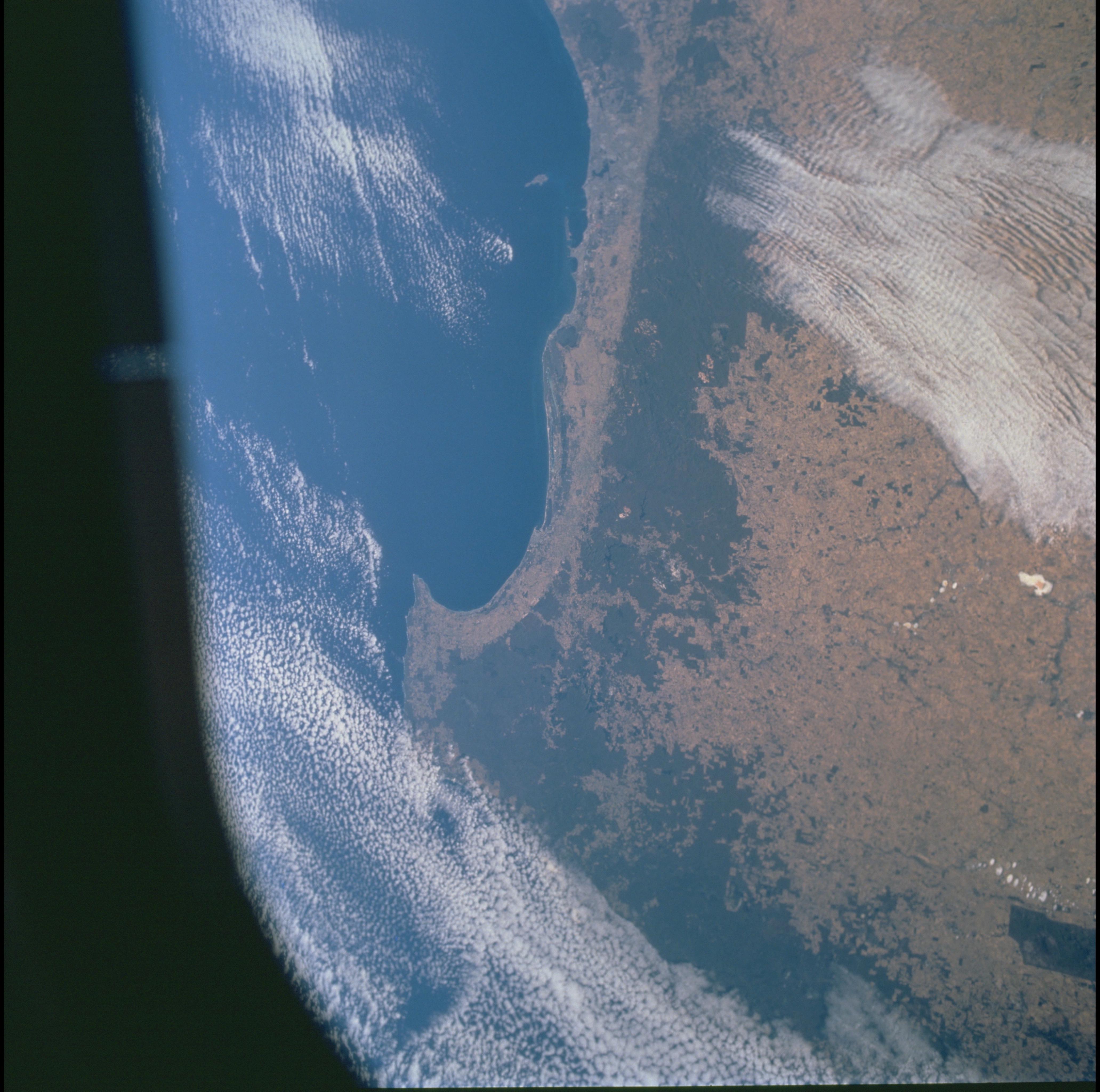
 Southwest Western Australia from space. The dark green is dense vegetation on and above the scarp, which has been retained for forest reserve and water catchment purposes. The sharp vegetation boundary on the coastal side coincides with the edge of the scarp.
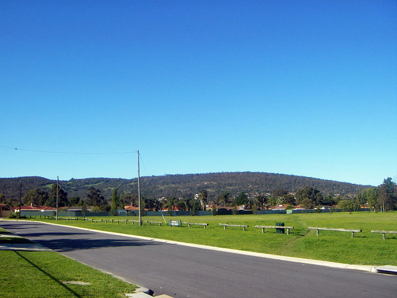
 View of the Darling Scarp (background) from the Swan Coastal Plain
The Darling Scarp, also referred to as the Darling Range or Darling Ranges, is a low escarpment running north-south to the east of the Swan Coastal Plain and Perth, Western Australia. It extends generally north of Bindoon, to the south of Pemberton, and easterly to include Mount Bakewell near York and Mount Saddleback near Boddington.
Contents
History
The feature was first recorded as General Darling Range by Charles Fraser, Government Botanist with Captain James Stirling aboard HMS Success in March 1827.
Maps from the 1830s show the scarp labelled "General Darlings Range"; this later became Darling Range, a name by which the formation was still commonly known in the late 20th century, despite common understanding of it being an escarpment. There is also a tendency to identify the locations on or to the east of the scarp as being in the "Perth Hills" (or simply "The Hills").
The earliest traverses by British settlers in the Swan River Colony occurred in the 1830s. The best known of these is the expedition of Ensign Robert Dale, who appears to have gone from a point near Guildford, to the south side of Greenmount Hill and up through the Helena Valley.[1]
Geology
The Darling Scarp originated as the local expression, in the Perth area, of the extensive Darling Fault, a major and ancient geological discontinuity separating the Archaean Yilgarn Craton in the east from the younger Pinjarra Orogen and overlying Phanerozoic Perth Basin to the west. The Darling Fault is exposed for over 1,000 km, from the area east of Shark Bay, to the southern coast of Western Australia east of Albany. The location of the scarp must once have coincided with the location of the fault, but the scarp has since eroded about 15 kilometres eastwards. The original location of the scarp is indicated in places by an unusual landform known as the Ridge Hill Shelf.
The Archaean granites and gneisses of the Yilgarn Craton form the high ground of the Perth Hills and can be observed in road cuts, with good examples in the Mundaring Weir area. The only exposed sediments of the Perth Basin, west of the fault, are of Cenozoic age, and comprise the material such as sandy limestone, travertine and dune sand on which the city of Perth is built, including sand dunes of Pleistocene age formed during the last Ice Age.
This area is also a distinct physiographic section of the larger Yilgarn Block province, which in turn is part of the larger West Australian Shield division.
Climate effects
Often the Bureau of Meteorology identify different weather for 'the hills' in comparison to that of the Swan Coastal Plain [2]
Also, in traditionally hot summers, strong easterly winds travelling across the scarp have presented serious issues for planes using the Perth Airport because of the alignment of the runways.[3] A documented accident in 1999 involving wind shear from the scarp is at the Perth Airport article. In addition, orographic uplift is produced when rainclouds move over the hills, giving higher rainfalls in settlements in the ranges compared with their coastal neighbours.
Landuse
The Darling escarpment has been exploited for stone quarries, forestry and bauxite mining. Extensive timber railways and timber mills and the supporting communities existed along the escarpment because of the high quality jarrah forests.[4]
Water supply
In the early twentieth century, most of the main rivers flowing off the escarpment had mainly been utilised for dams for water supply. The dams on the scarp, or slightly inland include: Mundaring Weir (on the Helena River), Serpentine Dam and Pipehead (Serpentine River), Wungong Dam, Churchman's Brook Dam, North Dandalup Dam, South Dandalup Dam (on the two Dandalup branches) and the Canning Dam (on the Canning River). The only free flowing water from the Darling Range in the Peel Region is the Dirk Brook in Keysbrook and the Murray River.
The scarp also defines the easternmost limit of the various aquifers present in the Perth Basin sediments, most notably the Southwest Yarragadee Aquifer. The scarp forms a divide between the hypersaline groundwaters typical of the Yilgarn Craton basement from the fresh ground waters of the Perth Basin. Some dams along the scarp are contaminated by seepage of saline water from the granite into the base of the dam's water column and must be periodically flushed to preserve water quality.
Rock quarries
Also in the early to mid-twentieth century numerous rock quarries existed on the edge of the escarpment - visible and affecting both the aesthetics and the environment of the escarpment.
In the area where the Helena River emerges from its valley to the sandplain, there are still four quarries evident, despite being unused as quarries for fifty years or more. Mountain [5] and Stathams [6] quarries are now managed as rock climbing locations.
- Bluestone quarry (1850s name), later known as Greenmount Quarry (1850s to 1920s), at Greenmount Hill on the west side of Greenmount National Park.
- Mountain Quarry (now usually signed as Boya Quarry), south of Greenmount Hill, which ceased operation in 1963.
- Byford brickworks (State Brickworks), shale scar visible from early 20th century to WW2 quarrying.
- Fremantle Harbour Works Quarry (sometimes, C. Y. O'Connor's Mole Reconstruction Quarry, and later known as the Public Works Quarry), now Hudman Road Amphitheatre at edge of Darlington - Boya localities border, operated from the 1900s to the 1930s.
- Statham's Quarry at Gooseberry Hill at northern edge of the Kalamunda Zig Zag formation.
- Armadale brickworks (State Brickworks), Bedfordale Hill, shale scar visible from 20th century quarrying, with an underground rail bypassing the South Western Highway to transport the ore.
There have also been visible quarries on the scarp in the Gosnells and Herne Hill areas.
Legislative restrictions upon such developments were initiated in the late twentieth century to prevent further visible scars on the western face of the scarp.
Bauxite mining
See also Bauxite mining in Australia
In the late twentieth century, the proving of bauxite deposits correlating to the extensive jarrah forests saw wide ranging protests against the proposals to mine the forests. Campaign to Save Native Forests was one group to oppose the activity.
The lengthy process of protest forced the government and miners to check their original proposals, and wide ranging processes to guard segments of the jarrah forests from mining ensued.
The current mining activity in the region is extensive - the main mines being Huntly and Willowdale.[7]
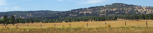
 Darling scarp from South West Highway between Armadale and Pinjarra
Railways
The building and developing of rail access across the scarp developed three separate main routes over a eighty years [8]
- The Eastern Railway first traversed the Darling Scarp in the 1880s along its first route through Greenmount (where three of the above quarries were later able to utilise the railway).
- By the 1890s the second route passed through Swan View Tunnel and John Forrest National Park.
- In the 1960s the third route utilised easier grades through the Avon Valley
- The Kalamunda Zig Zag or Upper Darling Range Railway ran up the southern steep side of the Helena Valley entrance until 1949.
- The Millars timber lines operating south to Yarloop, north through Jarrahdale up to Jarrahglen east of Byford and the Chandler mill.
Perth Suburbs on the Scarp
The localities or suburbs on the 'edge' of the scarp are those that sit at its western edge, and in most cases command excellent views of the Swan Coastal Plain:
The suburbs near Midland and Kalamunda are often referred to as the Perth Hills
Television transmission towers
The suburbs to the south of Kalamunda are the locations of the main Perth Metropolitan television station transmission towers. There is also another site at Mount Lennard near Collie that Services the Southwest areas including Bunbury.
Conservation
Dieback and fire
Also in the late twentieth century, dieback affecting jarrah timber in particular infected large tracts of the forest. Currently only the restriction of vehicle access has proved effective in slowing the spread of this disease. This gained greater acceptance and publicity through the decision to allow Rally Australia to operate along services roads provided that the vehicles had a thorough wash including the under carriage at the end of each stage.
In late 2004, the largest bushfire in the Northern Jarrah Forest for at least 100 years created significant issues for the forest as well. As a result of this fire intensity the Government increased the volume of controlled burns along the entire escarpment to reduce the build up of flammable materials.
In the early 2000s, Greenmount National Park and John Forrest National Park have been repeatedly burnt by bushfires - in most cases through suspected arson.
Darling Range Regional Park
A network of reserves of crown lands on the escarpment have been connected into a regional park to maintain and conserve parts of the escarpment.
In most cases the reserves or parks had individual names prior to being incorporated into the larger park, for example the Serpentine National Park, John Forrest National Park and the Greenmount National Park, or were simply known as State Forests (e.g. State Forest No.42).
Following a change in 2005, the separate parks have been known as the 'Parks of the Darling Range' - and take up 23,948 hectares on the scarp.[9] Further in August 2008 the parks were given indigenous names [10]
- Beelu National Park
- Korung National Park
- Midgegoroo National Park (formerly known as Canning National Park [11])
- Banyowla Regional Park (formerly known as Kelmscott-Martin Regional Park)
- Mundy Regional Park (formerly known as Kalamunda Regional Park)
- Wooroloo Regional Park (formerly known as Chidlow Regional Park)
- Wungong Regional Park
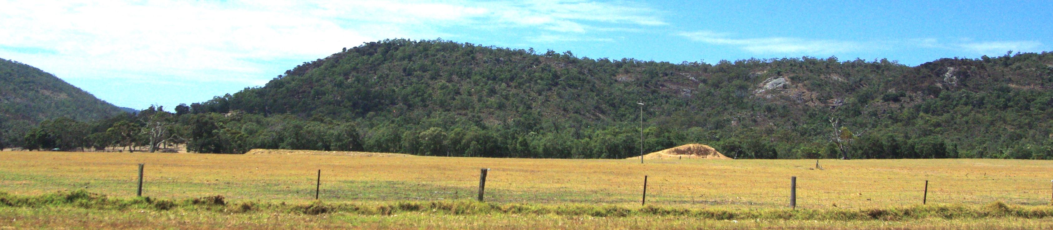
 Darling scarp from South West Highway between Armadale and Pinjarra
Highest points
- Mount Cooke -- 32°25′S 116°18′E / 32.417°S 116.3°E (582m)
- Mount Dale
See also
- Eucalyptus laeliae - also known as Darling Range Ghost Gum
- Jarrah Forest
Notes
- ^ Cross, Joseph (1833). "Journal of the Proceedings of a party of Officers and men, for the purpose of crossing the Darling Range of Mountains, under the orders of Lieutenant Preston, R.N.". Journals of Several Expeditions Made in Western Australia. London: J. Cross. pp. 6–14. http://en.wikisource.org/wiki/Journals_of_Several_Expeditions_Made_in_Western_Australia,_During_the_Years_1829,_1830,_1831,_and_1832. Retrieved 28 February 2009.
- ^ "Fire Danger is identified in this page for ''Coastal Plain'' and for ''Hills''". Bom.gov.au. http://www.bom.gov.au/weather/wa/forecasts/perth.shtml. Retrieved 2010-06-14.
- ^ "specifically stated as ''Significant turbulence is cased by the passage of easterly winds over the escarpment''". Users.ssc.net.au. http://users.ssc.net.au/mcmillan/ATC%20in%20WA/3_geography_and_weather_at_perth.htm. Retrieved 2010-06-14.
- ^ Darling Range Study Group & Benson, W. D (1982). Land use in the Darling Range, Western Australia : a report to the Premier of Western Australia The Group], Perth, W.A
- ^ "Climbs in WA". Web.archive.org. 2005-08-15. Archived from the original on 2005-08-15. http://web.archive.org/web/20050815082354/http://www.climberswa.asn.au/climbwa/crags.asp?region=Around+Perth&crag=Mountain_Quarry&sort=NAME. Retrieved 2010-06-14.
- ^ "Climbs in WA". Web.archive.org. 2008-07-20. Archived from the original on 2008-07-20. http://web.archive.org/web/20080720052707/http://www.climberswa.asn.au/climbwa/crags.asp?region=Around+Perth&crag=Stathams_Quarry&sort=NAME. Retrieved 2010-06-14.
- ^ 'Alcoa has two bauxite mines operating in the Darling Range in Western Australia: Huntly, which has been operating since the early 1970s and is the world's biggest bauxite mine, producing 20 million tonnes per annum; and Willowdale, established in 1984 and currently supplying 8.5 million tonnes per annum to Alcoa's Wagerup alumina refinery. source: http://www.aluminium.org.au/Page.php?d=1011
- ^ Higham, G.J.(1968) Over the range:railways across the Darling range of Western Australia:Midland to Northam and York Bassendean, W.A. Australian Railway Historical Society, W.A. Division
- ^ Mitchell, Samille (2008-9) What's in a name? Parks of the Darling Range Landscope Volume 24 number 2, pp.40-46.
- ^ "including a press release no longer available - regarding the component reserves within the parks". Roleybushcare.com. 2009-06-23. http://www.roleybushcare.com/bush-topics/109-new-aboriginal-names-for-regional-parks.html. Retrieved 2010-06-14.
- ^ "Midgegoroo National Park". Roleybushcare.com. 2008-10-07. http://www.roleybushcare.com/bush-reserves/58-canning-national-park.html. Retrieved 2010-06-14.
References
- Bean, Alison.(1993) A brief history of the Darling Range : for the Department of Planning and Urban Development. Perth, W.A. : The Dept. Darling Range Regional Park supplementary report ; no. 4. ISBN 0730953041
- Blainey, Geoffrey.(1997) White gold : the story of Alcoa of Australia St. Leonards, N.S.W. : Allen & Unwin. ISBN 1864483555
- (1970)The Darling Scarp : a natural entity: proceedings of symposium held at the Geography Department of the University of Western Australia, November 1969 Perth, W.A.: Nature Conservation Council of Western Australia,
- Department of Planning and Urban Development, Western Australia.(1993) The Natural resources of the Darling Ranges Perth, W.A. : The Dept., Darling Range Regional Park supplementary report ; no. 2. ISBN 0730953025
- Murphy, Mike.(1998) ( Coles, Helena - editor) Jarrahdalians : the story of the Jarrahdale Mine Booragoon, W.A. Alcoa of Australia. ISBN 064636670X
- Myers JS (1992) Pinjarra Orogen, in Geology and Mineral Resources of Western Australia: Western Australia Geological Survey, Memoir 3, 77-119.
- Schur, Basil. (1985)Jarrah forest or bauxite dollars? : a critique of bauxite mine rehabilitation in the jarrah forests of southwestern Australia Perth, W.A. : Campaign to Save Native Forests (W.A.). ISBN 0959744975 (pbk.)
- Watson, Lindsay (1995) The Railway History Of Midland Junction : Commemorating The Centenary Of Midland Junction, 1895-1995 Swan View, W.A : L & S Drafting in association with the Shire of Swan and the Western Australian Light Railway Preservation Association.
External links
Categories:- Geology of Western Australia
- Physiographic sections
- Darling Range

Wikimedia Foundation. 2010.