- Drumsna
-
Drumsna
Droim ar Snámh— Town — Motto: The ridge of the swimming Location in Ireland
 Drumsna
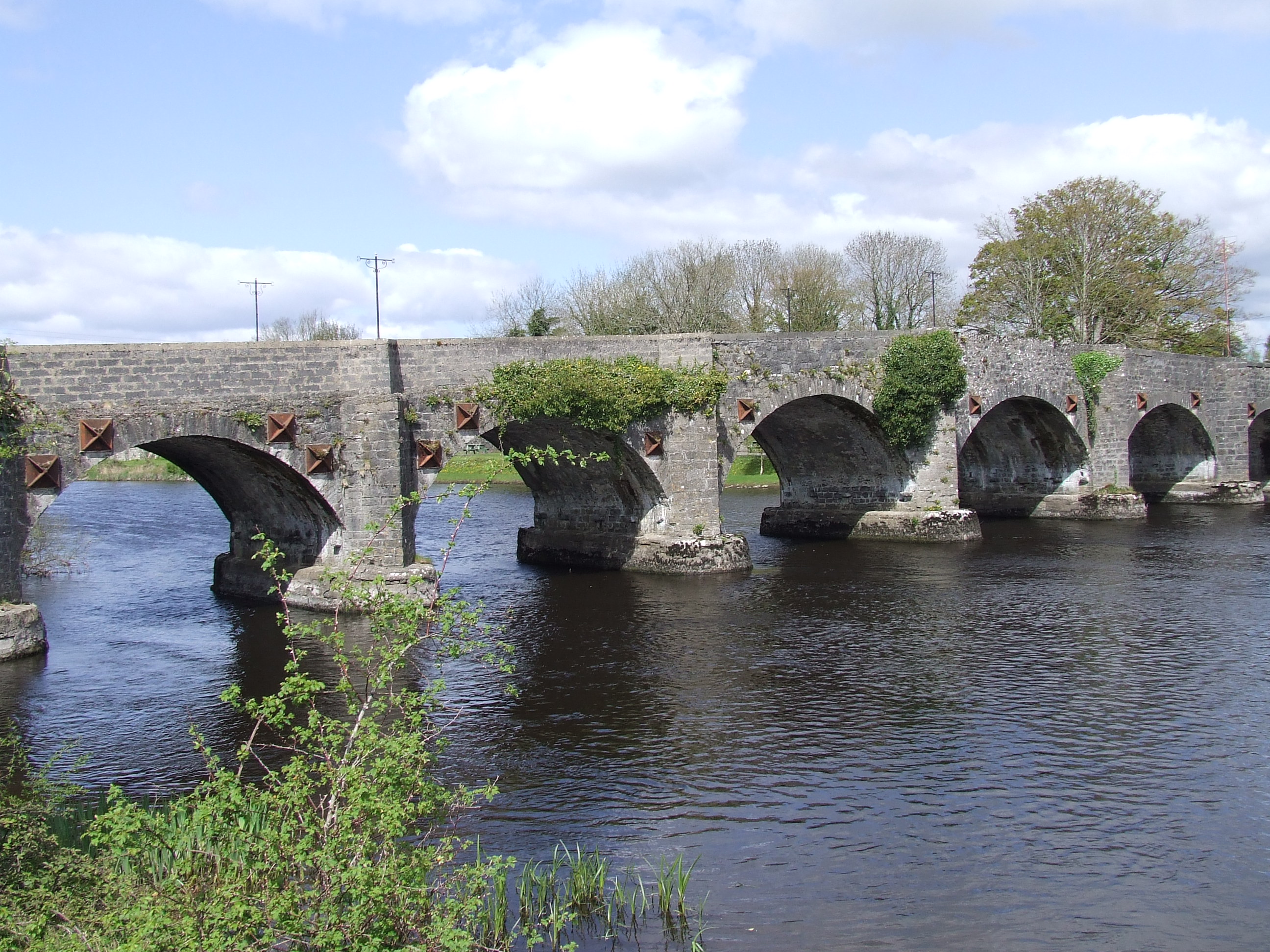
Coordinates: 53°55′44″N 8°00′15″W / 53.92886°N 8.00418°WCoordinates: 53°55′44″N 8°00′15″W / 53.92886°N 8.00418°W Country Ireland Province Connacht County County Leitrim Elevation 80 m (262 ft) Population (2002) - Urban 173 - Rural 532 Time zone WET (UTC+0) - Summer (DST) IST (WEST) (UTC-1) Irish Grid Reference N000982 Website drumsna.com  Stone bridge at Drumsna
May 2010 Plaque on bridge. 1795 rebellion
May 2010 River Shannon from Drumsna bridge
May 2010Drumsna (Irish: Droim ar Snámh which translates as the ridge of the swimming place) is a village in County Leitrim, Ireland. It is situated 6 km east of Carrick-on-Shannon on the River Shannon and is located off the N4 National primary route which links Dublin and Sligo. The harbour dates to 1817 and was a hive of commercial waterway activity until the more northern navigation canal to Carrick-on-Shannon was opened in 1850. Today, the waterway is busy with anglers and touristic pursuits in the summer months but at a much more leisurely pace.
Contents
History
Doon of Drumsna
An extraordinary man-made prehistoric fortification was identified only relatively recently in the Shannon-surrounded peninsula that is the northern tip of Kilmore Parish, in the Barony of Ballintober North, County Roscommon. Known as the "Doon of Drumsna" (though Drumsna is in County Leitrim) it was described in 1915 by W. F. de Vismes Kane - incidentally, the leading Irish entomologist of his time - in the Proceedings of the Royal Irish Academy 32c: 324-332. In the 1980s it was investigated by Dublin Office of Public Works archaeologists Tom Condit and Victor Buckley with the aid of geophysical expert Damien McGarry and a grant from the Royal Irish Academy. They published their conclusions in 1989 in the journal Emania (6: 12-14). The following is summarised from those publications.
The Doon (from Dun, a fort) evidently was designed primarily to protect the seat of Connacht government at Rathcroghan 14 miles (23 km) to the Southwest from invaders from the north. In practice it must have been most beneficial to the people of the area immediately south of it: the area that would a millennium later become the O'Beirne country of Tir Briuin. The reason for the location of the Doon is that on the east, north, and especially the west sides of the peninsula are the only shallows that can be forded on the River Shannon north of Athlone. By blocking where invaders from the north could enter Roscommon. most readily the Doon was a major defence in the northern frontier of Connacht.
The main barrier was a massive earthen rampart across the neck of the peninsula in what are now the townlands of Ardanaffrin and Lackagh, south of the T3 main road between Longford town and Carrick-on-Shannon which crosses the bridges at Drumsna and Jamestown. The canal shown on the map is not part of the Doon; it dates from the 19th century. The main earthworks were about 6m high and 30m wide. Smaller earthworks with a ditch between them paralleled it on both its northern and southern sides, around 4m and 40m respectively from the main barrier. Its northern side was steeply scarped and faced an almost impassable bog up to 100 km wide which, however, could be crossed on two drier ridges, each leading to a large gap or gate in the barriers. The main gate was 26m wide and had gateposts that would have been 2m square. The eastern gate was 23m wide at its northern entrance funnelling to 16m. Purposes of the gates evidently were to enable refugees from the north to be screened as potential friends or enemies and cattle raided in the north to be brought to protection in the south.
There were two subsidiary barriers. One ran south from the western end of the main one along the shallows there, especially at Corry township. Its surviving remains indicate that it consisted of parallel banks and ditches. The second subsidiary barrier apparently extended north from the eastern end of the main earthworks towards Drumsna Bridge. Its purpose evidently was to keep out invaders by boat from the eastern side of the Shannon. Kane's discovery of iron-shod wooden piles implies that this barrier was a forest of large stakes made from tree-trunks.
Condit and Buckley estimated that the fortifications could have required the work of 10,000 people for two years, 50,000 to 60,000 trees, and removal of 150,000 cubic meters of earth. They suggested that they date from the Iron Age, two thousand or more years ago at the time of the Táin Bó Cúailnge and of the troubles between Queen Medb of Connacht and the peoples of the north. Though the Doon dates from long before the O'Beirnes became a Sept it is the most important archaeological site in Tir Briuin and one of the two most important of its particular kind in Ireland - the other is the similar Dorsey in Armagh. As such it deserves far more attention and publicity, and indeed preservation, than it has had hitherto. And it might be renamed more geographically accurately "The Doon of Tir Briuin".
19th and 20 centuries
In the late 19th century, Drumsna was the main trading town in Leitrim with its own jail and courthouse. It was the rest place for horse drawn carriages and the harbour was a thriving delivery port. In 1850, the construction of the canal led to a change of the Shannon navigation which altered the status of Drumsna. Ashfort House, near Drumsna, was originally the home of the Caulfield family. It was purchased by the Waldrons of Cartron in 1744. It was here in January 1848 that Hubert Kelly Waldron JP was murdered in a non-political incident when the local coroner attempted to serve him with a writ.[1]
Until 1996 the main N4 Dublin to Sligo road passed through the village which was then bypassed.
People
- The writer Anthony Trollope (24 April 1815 – 6 December 1882), lived in the village for a period during the 1840s, where he wrote The Macdermots of Ballycloran.
After an unhappy childhood, and an unpromising start to his career, Trollope went on to write 47 novels and rise to the top of his profession as a senior civil servant in the Post Office, he also was responsible for the introduction of the pillar box.
It was during his stay in The Ivy Tree Inn (now Taylor's Pub) Drumsna that Trollope was inspired to write his first (and some might claim) best novel; The MacDermots of Ballycloran. Trollope based his story on local characters and set the plot around the melanchony ruins of Ballycloran Castle on the outskirts of Drumsna village, these ruins still stand today.
Anthony Trollope went on to became one of the most successful, prolific and respected English language novelists of the Victorian era. Some of Trollope's best-loved works, known as the Chronicles of Barsetshire revolve around the imaginary county of Barsetshire. He also wrote penetrating novels on political, social, and gender issues and conflicts of his day. Trollope died in London in 1882 and is buried in Kensal Green Cemetery.[2]
Ballycloran
"I was located at a little town called Drumsna, or rather village, in the county Leitrim, where the postmaster had come to some sorrow about his money; and my friend John Merivale was staying with me for a day or two. As we were taking a walk in that most uninteresting country, we turned up through a deserted gateway, along a weedy, grass-grown avenue, till we came to the modern ruins of a country house. It was one of the most melancholy spots I ever visited. I will not describe it here, because I have done so in the first chapter of my first novel. We wandered about the place, suggesting to each other causes for the misery we saw there, and, while I was still among the ruined walls and decayed beams, I fabricated the plot of The Macdermots of Ballycloran." Anthony Trollope. Anthony Trollope is universally recognised as one of the great Victorian novelists, however when he visited Drumsna in 1843 he was in the middle of an unpromising career in the postal service, he went on to write 47 novels and rise to the top of his profession as a senior civil servant. Now we are not promising that Drumsna works this magic on everyone who visits or stays here, but we don't rule it out either. The poetic inspiration that AT took from Drumsna and the surrounds of Ballycloran Castle also inspired the people of Drumsna in their own artistic endeavor with the making of Ballycloran Revisited in 2006. Anthony Trollope was further remembered in the village with the launch of the Historic Trollope Trail by President Mary McAleese in September 2008.[3]
- Robert Strawbridge(1732–1781), one of the pioneers of Methodism in the United States, was born in Gortconnellan, Drumsna. He was a member of the only Protestant family in Drumsna. He moved first to Sligo and then emigrated to Maryland USA in the early-to-mid 1760's. Strawbridge formed the First Society of Methodism in America which met in the home of John England and the altar he built there was made with wood brought from his farm in Drumsna. A second Methodist class was formed nearby at the Andrew Poulson’s home, when the crowds became too large for the Poulson house, Robert would preach under an old oak tree in the meadow which was called "Strawbridge Oak".
After 13 years as tenants on the England land, in 1773 Robert purchased 50 acres (200,000 m2) from Mr. John England for the sum of £50. However, in 1776, he was offered a home, rent free, on the Hampton Estate owned by Captain Ridgely, whose wife was an ardent Methodist. However, his ministry was not to last much longer. On a preaching mission, in 1781, not far from his home, he succumbed to an unspecified illness and died at age 49 on the Wheeler farm in Riderwood. An early convert of Robert’s, Richard Owings, preached the funeral sermon, and Strawbridge was buried at the Wheeler Farm.
The Wesleyan historical society erected a memorial to Robert Strawbride in Drumsna in 1992.
- Thomas Heazle Parke, African explorer and surgeon (1857–1893), was born in Clogher House, Drumsna, Co Roscommon. He received his formal education at the Reverend Edward Power's private school, which was located at 3 Harrington Street, in Dublin.
Parke studied medicine at the Royal College of Surgeons and practised in the City of Dublin Hospital in Baggot Street. He then served in the Richmond, Whitworth and Hardwicke Hospitals, before finally getting his license from the Royal College of Surgeons of Ireland in 1878.
He served on the relief expedition to Khartoum to relieve the doomed General Gordon in 1885 and accompanied Sir Henry Stanley on his famous Nile Expedition of 1887.
When he died in Scotland his coffin was brought back to Ireland and drawn on a gun carriage from the Dublin docks to Broadstone station for his final journey to his beloved Drumsna. He was buried in the old village churchard, aged just 36.
A bronze statue of Parke stands on Merrion Street in Dublin, outside the Natural History Museum. On the granite pedestal is a bronze plaque depicting the incident on August 13, 1887 when Parke sucked the poison from an arrow wound in the chest of Capt. William G. Stairs to save his life. In addition to the statue, Parke's uniform and some of his personal belongings (his uniform etc) can be seen on the first floor of the Museum.
Amenities and facilities
Angling
Drumsna is widely acknowledged as an anglers paradise. The many unpolluted lakes and rivers in the area support a huge population of wild fish. Coarse fish species include Bream, Roach, Rudd, Hybrids, Tench, Pike, Perch and Eels. The Shannon flows through the village and there are several good fishing lakes close by. The Shannon has Bream, Rudd, Roach, Tench, Perch and Pike. Lough Aduff just outside the village is a very good Bream and Roach water with good Tench present to 5 lb (2.3 kg) . Headford is a small lake located about 1½ mile north east of the village of Drumsna, this lake has a good stock of Bream to 3 lb (1.4 kg) and some very good Tench fishing can be had here, especially during the summer months.
Drumsna Roman Catholic Church
Built in 1845 and part financed from the proceeds of a trip to Rome by the then Parish Priest, Father George Geraghty, the building boasts one of the largest church bells in the country. The church also contains a statue to the Virgin Mary which was the only surviving item from Belmount House when it was destroyed by fire. Sunday mass is celebrated in the church by Father John Wall at 9:30 am.
Transport
- Drumsna railway station opened on 1 September 1863, and finally closed on 17 June 1963.[4]
List of Townlands around Drumsna
- Effrinagh
- Mountcampbell
- Foxborough
- Lavagh
- Lisduff
- Dristernan
- Gortconellan
- Lislea
- Drumnadober
- Charlestown
- Gowel
- Liscallyroan
See also
References
- ^ The Freeman's Journal, 28 January 1848.
- ^ "Welcome to Drumsna". GoIreland. http://www.goireland.com/leitrim/drumsna.htm. Retrieved 2008-06-25.
- ^ http://www.drumsna.com
- ^ "Drumsna station". Railscot - Irish Railways. http://www.railscot.co.uk/Ireland/Irish_railways.pdf. Retrieved 2007-10-12.
Categories:- Untranslated Irish place names
- Towns and villages in County Leitrim


Wikimedia Foundation. 2010.