- Malitbog, Bukidnon
-
Municipality of Malitbog
Munisipyo sa Malitbog

SealNickname(s): Home of the Country's Future Millionaire's Map of Bukidnon showing the location of Malitbog, Bukidnon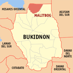
Coordinates: 8°25′35″N 124°49′39″E / 8.42639°N 124.8275°E Country Philippines Region Region X Province Bukidnon Districts 1st District Barangays 11 Incorporated (town) 1963 Government - Mayor Osmundo N. Dela Rosa - Vice Mayor Eddie P. Kilem Area - Total 581.85 km2 (224.65 sq mi) Population (2000) - Total 19,315 - Density 0.03/km2 (0.0116/sq mi) Time zone PST (UTC+8) ZIP code 8704 Area code(s) 88 Malitbog is a 3rd class municipality in the province of Bukidnon, Philippines. According to the 2000 census, it has a population of 21,948 people in 3,808 households.
Contents
History
The pioneers of the municipality were a group of Bukidnon tribe who has a small settlement along a spring called Abo-on.
As their number increased, they began to call the entire area as Abo-on. However, there were divergent opinions to have this name because Abo-on refer only to a small cluster of settlers in the area.
The name was then changed to Malitbog, on the account of Malitbog River transversing their settlement and likewise the principal source of fishing, the native’s favorite livelihood. Their seat of government near the Malitbog River was also another consideration.
By virtue of Executive No. 42, dated June 25, 1963, Malitbog became a 5th Class municipality by operation of the provision of Section 2 of Republic Act 1515 and considered a regular municipality pursuant to Republic Act 23 and 88 duly signed by President Diosdado Macapagal.
Geography
Location
Malitbog is one of the 22 political subdivisions of the province of Bukidnon. Located at the northernmost part of the province, it lies between parallel 8°25'35" and 8°36'8" North Latitude and Meridians 124°49'39" and 125°11'39" East Longitude. Malitbog is a land locked municipality bounded on north by the municipality of Claveria and on the western side by Tagoloan - both of which are part of Misamis Oriental. Bounding it on its southern part are the municipalities of Manolo Fortich and Impasug-ong of Bukidnon Province while on its eastern side is the municipality of Esperanza, Agusan del Sur.
The Municipality is about 40 km. from the regional capital - Cagayan de Oro City, and about 2½ hours ride from the Provincial Capital, Malaybalay City. It is reachable via Tagoloan and is approximately about 2 hours ride from the City of Cagayan de Oro through secondary and first class road type (gravel and concrete pavement).
Land area
The municipality of Malitbog is subdivided into 11 political subdivisions. It covers a total land area of 581.85 km² which about 7.02 percent of the land under the province's jurisdiction. Among its eleven barangays, San Luis occupied the largest area with a total coverage of 388.68 km² - about 66.8 percent of Malitbog's land area. Barangay Poblacion on the other hand is the smallest in terms of land area coverage with only about 6.66 km². This represents a mere 1.14 percent of the municipality's area coverage. The data below shows the full details of area subdivisions for the municipality of Malitbog.
Land area By Barangay, Malitbog, Bukidnon Name of Barangay A & D (km²) Forest land (km²) Land area (km²) Percent of total 1. Kalingking 7.42 2.73 10.15 1.74 2. Kiabo 7.99 19.65 27.64 4.75 3. Mindagat 13.45 4.00 17.45 3.00 4. Omagling 9.39 0.03 9.42 1.62 5. Patpat 2.85 8.69 11.54 1.98 6. Poblacion 5.10 1.56 6.66 1.14 7. Sampiano 0.93 39.90 40.83 7.02 8. San Luis 12.56 376.11 388.68 66.80 9. Siloo 3.78 42.61 46.38 7.97 10. Sta. Inez 6.92 7.30 14.22 2.44 11. Sumalsag 6.31 2.57 8.88 1.53 Total 76.70 505.15 581.85 100.00 Source: MASSO
Climate
The climate in Malitbog is classified as belonging to Type IV or Intermediate B which is typical throughout the province. Its climate has been characterized by moderate season from February to April and wet season starting from May which would last up to January.
Topography
Being naturally characterized by mountains and hilly terrain, slope ranging from 30 to 50 percent and above are therefore the most prevalent category. These are the steep to very steep slope found mostly in mountains areas. The largest part which can be found at the north and northeastern part having an elevation of 1,000 to 1,500 meters above the sea level. Smaller portion at the northern part has the highest elevation of 1,500 to 2,400 meters above sea level. Erosion maps shows that slight to moderate erosion can be found in this area. From Barangay San Luis and Kiabo going southwestern part, it has patches of slope 30 to 50 percent and above with an elevation 200 to 1,000 meters above sea level. Major portion of this area has a severe erosion only small area have the slight erosion based on thematic map.
It can be noted from the derived slope map that even areas where settlements are established are in lands with slope more than 18 percent in grade. Major portion of this area can be found at the northwestern part covers 8 barangays with an elevation of ranging from 200 to 1,000 meters above sea level. Largest part of the area has severe erosion. Other areas with 18 percent slope can also be found near the border of Malitbog and Agusan del Sur. The elevation of this area is 600 to 800 meters ASL with slight erosion based in the erosion map. It can also be well further noted from the map that slope under the 0-3 percent are 3-8 percent are small patches that are scattered mostly in the southwestern part and at Calabugao Plain near the Malitbog and Agusan del Sur. These grades are supposedly ideal for settlements and agricultural production yet combine together its area is measured and their corresponding areas.
Land classification
The total land area of the municipality of Malitbog is approximately at 581.85 km² based on Administrative/Thematic Maps of DENR-CENRO Office No. B-340 and certified by Land Management Bureau. The classified forest land is estimated at 505.15 km² or 86.82 percent of the total land area. Only 76.70 km² or 13.18% of the total land area of Malitbog is classified as alienable and disposable lands.
The Thematic Maps from CENRO that are gathered from Topographic Map of NAMRIA, showed that there are three categories of vegetative cover in the municipality: Timber Lnd is one of the categories that covers the largest part of the total land area with an estimated area of about 338.73 km² or 58.22 percent of the total land area of the municipality. Timberland is within Forest Land that can be found only in Barangay San Luis and Kiabo.
Cultivated Area developed for agricultural endeavors and areas settled in by people covers an estimated area of 162.24 km² or 27.88 percent of the total land area of Malitbog. Alienable and Disposable Lands is within this cultivated area having an area of only 76.70 km². These A&D Lands are intended for settlements and agricultural development and can be found in the north and northwestern side of Malitbog. All barangays of Malitbog have A&D lands, though these are particularly small with barangay Siloo, Sampiano and Sta. Inez. The total cultivated area minus the A&D lands will have a difference of 85.54 km² or 14.70 percent of the total land area of Malitbog. This area is within forest land can be found also in all barangays.
Grassland on the other hand covers most part of barangay Sampiano and Siloo with small patches dots of barangay San Luis. Grassland category is within forest land having an estimated area of 80.88 km² or 13.90 percent of the total land area of Malitbog.
Barangays
Malitbog is politically subdivided into 11 barangays.
- Kalingking
- Kiabo
- Mindagat
- Omagling
- Patpat
- Poblacion
- Sampiano
- San Luis
- Santa Ines
- Silo-o
- Sumalsag
External links
Municipalities Baungon • Cabanglasan • Damulog • Dangcagan • Don Carlos • Impasug-ong • Kadingilan • Kalilangan • Kibawe • Kitaotao • Lantapan • Libona • Malitbog • Manolo Fortich • Maramag • Pangantucan • Quezon • San Fernando • Sumilao • TalakagComponent cities Malaybalay • ValenciaCategories:- Municipalities of Bukidnon


Wikimedia Foundation. 2010.