- Dunga Bunga
-
Dunga Bunga — City — ڈونگہ بونگہ 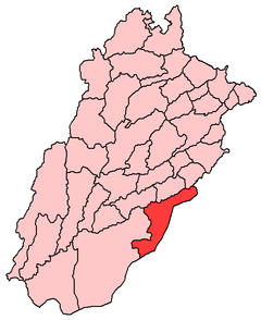
 Dunga Bunga
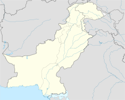
Coordinates: 29°27′N 73°09′E / 29.45°N 73.15°ECoordinates: 29°27′N 73°09′E / 29.45°N 73.15°E Country  Pakistan
Government – Famous Leader Rao Mujahid Ali – Old Leader Rao Muratab Ali Khan Late, Chairmen of City Elevation 154 m (505 ft) Population – Estimate (2006) 100,000 Time zone PST (UTC+5) Calling code 063 Dunga Bunga (Urdu: ڈونگہ بونگہ) is a small city in Bahawalnagar District in the Punjab province, Pakistan. The city hosts the Union council of Bahawalnagar Tehsil[1] and is located near to the city of Bahawalnagar at 29°45'0N 73°15'0E with an altitude of 154 metres (505 ft).[2] It lies on the Haroonabad-Bahawalnagar road.
The population of Dunga Bunga is around 100,000 according to the 2006 census. Dunga Bunga has more than 50 neighboring villages. The nearest towns are Soondha, Gulab Ali and Rasulpura.
Contents
Etymology
The name Dunga Bunga is Hindustani. Dunga means downside and bunga means a locality. Older people of Dunga Bunga assert that the name of city is associated with two Sikh brothers, Dunga and Bunga.
History
Dunga Bunga is very close to the Indian border. The border area of Dunga Bunga was used for smuggling to India because for many years there was no line of control.
In 2003 unrest broke out in the town when hospital officials refused to conduct an autopsy on a Tonga driver. The family of the driver were believed to have been treated badly and this resulted in mob violence and police retaliation. By the time calm was restored, 19 police officials were reported injured, a labourer and shopkeeper were killed, and five others were seriously injured. These five were taken to a hospital in Bahawalpur, the district capital.[3]
Places
Jane Mandir (Temple) is one of the historical buildings in the city.
Union councils
Main Dunga Bunga
The main area of this union council includes UC Dunga Bunga.
Dunga Bashnoyia
Dunga Bashnoyia includes the area far behind Dunga Bunga Bypass. It starts at qureshi chowk and ends at the bypass of Dunga Bunga from the Gulab Ali side.ROAD length 10 Km
Dunga Akuka
Dunga Akuka consists of the Akuka area. It starts at the main city bazaar of Dunga Bunga and runs to the veterinary Hospital and Haroonabad Road at the city limits.
Educational institutes
- Government Girls High School
- Government Higher Secondary School for Boys
- Fouji Foundation Model School, Dunga Bunga Campus
- Sir Syed Public School (SSPS)
- Paramount Public School
- Milli Public School
- City Public School
- Fauji Foundation Vocational Training School
- Jamia Rahimia Dunga Bunga (for boys)
- Jamia Noor-un-Nissa Dunga Bunga (for girls)
- Al-khidmat foundation training center (for girls)
- Sir Syed High Standard Academy for Science and Arts
- Ujala Free Library
Medical institutes
Medical facilities include a number of private medical clinics, but only few qualified doctors. Health facilities are primarily being provided by a Rural Health Center situated within the city. A Women Medical Officer; Dr. Ambreen Zeeshan has recently been appointed at R.H.C. Dunga Bunga to address to the issues of the females of the area. The Sohail Surgical Hospital and a veterinary hospital are also there on the Highway Road.
Organization
Ujala Foundation is the only organization working for needy and poor people.the Mission of Ujala Foundation is "SOCIAL CHANGE THROUGH EDUCATION".The detailed information can be get from the website of Ujala Foundation www.ujala.org.pk
References
Categories:


Wikimedia Foundation. 2010.