- Ocampo, Camarines Sur
-
Ocampo — Municipality — Map of Camarines Sur showing the location of Ocampo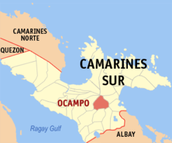 Location in the Philippines
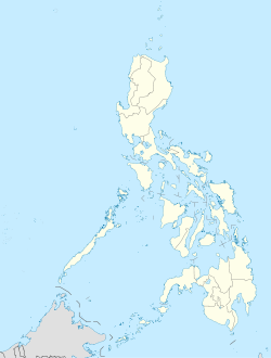
 Ocampo
Coordinates: 13°34′N 123°23′E / 13.567°N 123.383°ECoordinates: 13°34′N 123°23′E / 13.567°N 123.383°E Country Philippines Region Bicol Region (Region V) Province Camarines Sur District 2nd district(Central Bay) Founded Barangays 25 Government - Mayor Area - Total 118.33 km2 (45.7 sq mi) Population (2007) - Total 39,759 - Density 336/km2 (870.2/sq mi) Time zone PST (UTC+8) ZIP code Income class 3rd class municipality; partially urban Ocampo is a 3rd class municipality in the province of Camarines Sur, Philippines. According to the 2007 census, it has a population of 39,759 people.
History
Historical documents revealed that the municipality of Ocampo , known before as Mabato-bato, was existing since 1735. Mabato bato started as a sitio which was described as abounding with rocks and boulders of various sizes which were scattered over the place.
Since the early 1900's, the town of Ocampo had been a part of Pili though it separated years later, in 1948, and became an independent municipality.
August 13, 1949 marked a major event in the history of the town as this was the inauguration date of Ocampo's elevation into a municipality. It was also during this day when the name Matobato was officially changed into Ocampo, in honor of the late Don Julian Ocampo, then the governor of Camarines Sur.
Ocampo is the place where Governor Luis Villafuerte chose to build a sprawling deer sanctuary where at present houses different deer species from both local and foreign origins. This has served both for tourist attraction and commercial purposes.
Barangays
Ocampo is politically subdivided into 25 barangays.
- Ayugan
- Cabariwan
- Cagmanaba
- Del Rosario
- Gatbo
- Guinaban
- Hanawan
- Hibago
- La Purisima Nuevo
- May-Ogob
- New Moriones
- Old Moriones
- Pinit
- Poblacion Central
- Poblacion East
- Poblacion West
- Salvacion
- San Antonio
- San Francisco
- San Jose Oras
- San Roque Commonal
- San Vicente
- Santa Cruz
- Santo Niño
- Villaflorida
External links
- Philippine Standard Geographic Code
- 2000 Philippine Census Information
- 2007 Philippine Census Information
- Official Site of the Province of Camarines Sur
Metropolitan Naga Development Council Municipalities Baao • Balatan • Bato • Bombon • Buhi • Bula • Cabusao • Calabanga • Camaligan • Canaman • Caramoan • Del Gallego • Gainza • Garchitorena • Goa • Lagonoy • Libmanan • Lupi • Magarao • Milaor • Minalabac • Nabua • Ocampo • Pamplona • Pasacao • Pili • Presentacion • Ragay • Sagñay • San Fernando • San Jose • Sipocot • Siruma • Tigaon • TinambacComponent city IrigaIndependent component city (Administratively independent from the province, but grouped under Camarines Sur by the National Statistics Office)Categories:- Municipalities of Camarines Sur


Wikimedia Foundation. 2010.