- Kaohsiung
-
"Dagao" redirects here. For the ethnic group, see Dagara people.
Kaohsiung
高雄— Special municipality — Kaohsiung City · 高雄市 Clockwise from top: Kaohsiung skyline, Kaohsiung Confucius Temple, Liuhe Night Market, World Games Stadium, Port of Kaohsiung, Central Park Station

SealNickname(s): The Harbor City (Gangdu), The Maritime Capital, The Waterfront City Kaohsiung City shown within the Taiwan islands Satellite image of Kaohsiung
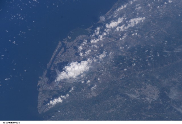
Coordinates: 22°38′N 120°16′E / 22.633°N 120.267°ECoordinates: 22°38′N 120°16′E / 22.633°N 120.267°E Country  Republic of China (Taiwan)
Region Southern Taiwan City seat Lingya District and Fengshan District Government – Mayor Chen Chu (DPP) Area – Total 2,946.2527 km2 (1,137.6 sq mi) Elevation 9 m (30 ft) Population (2010) – Total 2,769,072 – Density 939.9/km2 (2,434.2/sq mi) Population rank 2 Postal code 800-813, 817-819 Area code(s) (0)7 Districts 38 Website www.kcg.gov.tw/EN Kaohsiung (Chinese: 高雄; pinyin: Gāoxióng; Pe̍h-ōe-jī: Ko-hiông; old names: Takao, Takow, Takau) is a city located in southwestern Taiwan, facing the Taiwan Strait on the west. Kaohsiung, officially named Kaohsiung City, is divided into thirty-eight districts. The city is one of five special municipalities of the Republic of China (Taiwan). On December 25, 2010, it merged with Kaohsiung County to form a larger municipality.[1]
Kaohsiung is the second largest city in Taiwan, with a population around 2.9 million.[2] It is a center for manufacturing, refining, shipbuilding, and other light and heavy industries. A major port, through which pass most of Taiwan's marine imports and exports, is located at the city but is not managed by the city government.
Kaohsiung International Airport serving the city is the second largest airport in Taiwan. The Port of Kaohsiung is the largest harbor in Taiwan. Kaohsiung is the terminal of the Sun Yat-sen Freeway. The city is served by the railway stations of Western Line and Pingtung Line. Taiwan High Speed Rail connects it with Taipei City. The Kaohsiung Mass Rapid Transit, the city's subway system, was launched in early 2008. Kaohsiung was the host city of the 2009 World Games, a multisport event primarily composed of sports not featured in the Olympic Games. The city is also home to the Republic of China Navy.
Contents
History
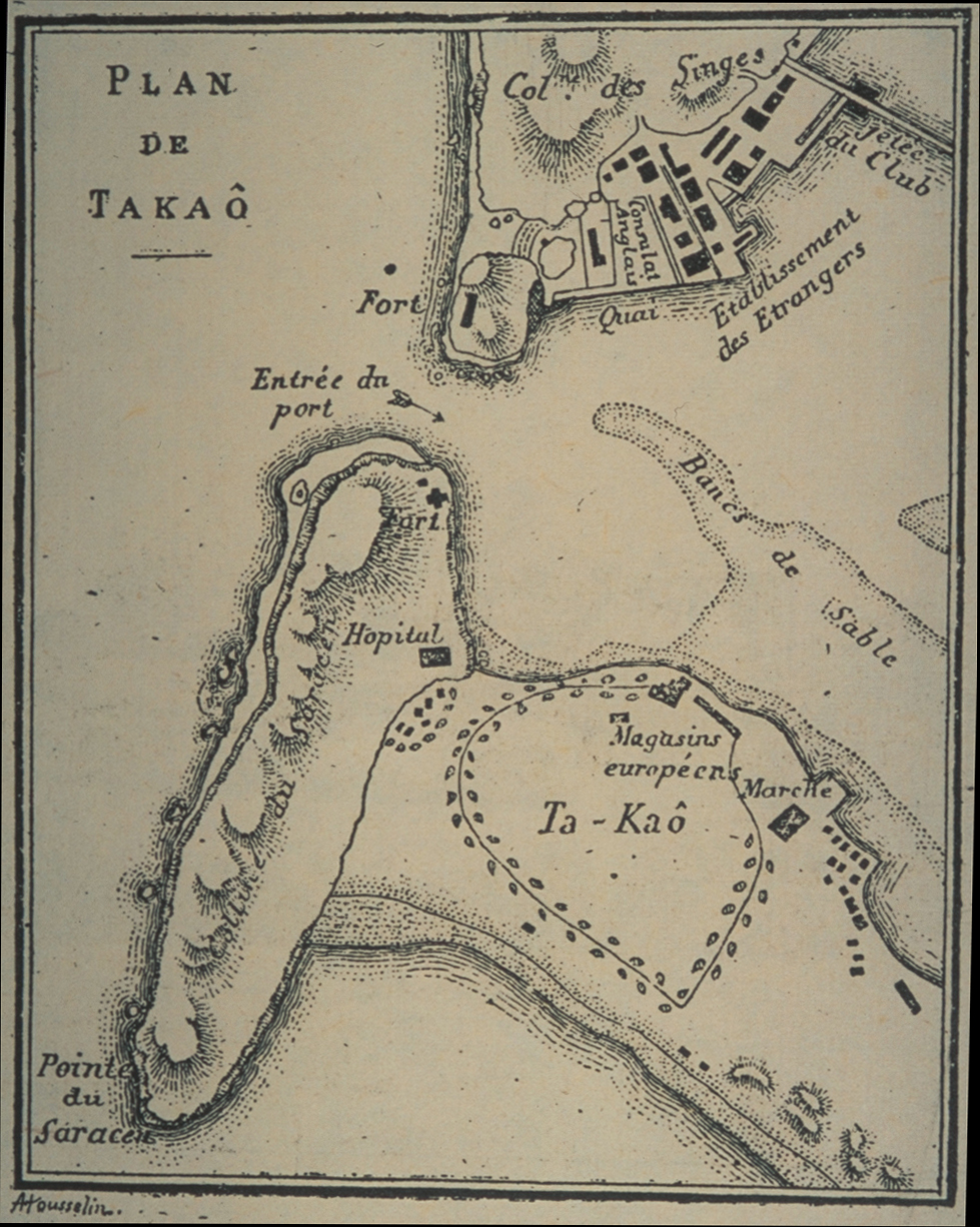
Main article: History of Kaohsiung The port of Ta-kau, 1893
Founded near the end of the 17th century, the village was known as Takau (Chinese: 打狗; pinyin: Dǎgǒu; Pe̍h-ōe-jī: Táⁿ-káu; literally "beat the dog") in the Hoklo language spoken by most of the early immigrants. The name originates from the Makatao language of the local aboriginal tribe and translates as "bamboo forest". The Dutch established Fort Zeelandia in 1624 and defeated the local tribes in 1635. They called the place Tancoia. The Dutch were later expelled by the Kingdom of Tungning government founded by Ming Dynasty loyalists of Koxinga in 1662. Zheng Jing, the son of Koxinga, renamed the village Wannian Zhou (simplified Chinese: 万年洲; traditional Chinese: 萬年州; pinyin: Wàn Nián Zhōu; literally "region of ten thousand years") in 1664. The name was restored to Takau in the late 1670s, when the town expanded dramatically with immigrants from mainland China. In 1684 the Qing Dynasty annexed Taiwan and renamed the town Fengshan County (simplified Chinese: 凤山县; traditional Chinese: 鳳山縣; pinyin: Fèngshān xiàn; literally "phoenix mountain"), considering it a part of Taiwan Prefecture. It was first opened as a port during the 1680s.
In 1895, Taiwan was ceded to Japan as part of the Treaty of Shimonoseki. It was during this period that the city's name was changed from 打狗 (Taiwanese: Táⁿ-káu) to 高雄 (romaji: Takao). While the sound remained more or less the same when pronounced in Japanese, the literal meaning of the name changed from "Beating Dog" to "High Hero". The Japanese developed Takao, especially the harbour. An important military base and industry center, the city was heavily bombed by Task Force 38 and FEAF during 1944–1945.
After control of Taiwan was handed to the Republic of China in 1945, the official romanization of the city name came to be "Kao-hsiung", based on the Wade–Giles romanization of the Mandarin reading of the kanji name.[3] Kaohsiung was upgraded to a special municipality on July 1, 1979, by the Executive Yuan, which approved this proposal on November 19, 1978. The Kaohsiung Incident took place in Kaohsiung on December 10, 1979.
Geography
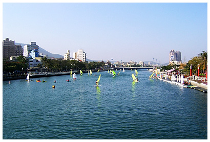
 The Love River
The city sits on the southwestern coast of Taiwan facing the Taiwan Strait. The downtown areas are centered around Kaohsiung Harbor with the island of Qijin on the other side of the harbor acting as a natural breakwater. The Love River (or Ai River) flows into the harbor through the Old City and downtown. Zuoying Military Harbor lies to the north of Kaohsiung Harbor and the city center. Kaohsiung's natural landmarks include the coral mountains Ape Hill, Shoushan and Banpingshan.
Climate
Kaohsiung is located south of the Tropic of Cancer. The climate is tropical, specifically a tropical wet and dry climate (Koppen Aw), with average temperatures ranging from between 18.6 and 28.7 degrees Celsius, and average humidity between 60 and 81%. Average annual rainfall is approximately 1785 mm, focused primarily from June to August.
Climate data for Kaohsiung City (1971–2000) Month Jan Feb Mar Apr May Jun Jul Aug Sep Oct Nov Dec Year Average high °C (°F) 23.4
(74.1)24.1
(75.4)26.5
(79.7)28.8
(83.8)30.4
(86.7)31.5
(88.7)32.1
(89.8)31.5
(88.7)31.2
(88.2)29.7
(85.5)27.2
(81.0)24.6
(76.3)28.4 Daily mean °C (°F) 18.8
(65.8)19.7
(67.5)22.3
(72.1)25.2
(77.4)27.2
(81.0)28.4
(83.1)28.9
(84.0)28.3
(82.9)27.9
(82.2)26.4
(79.5)23.4
(74.1)20.2
(68.4)24.7 Average low °C (°F) 15.1
(59.2)16.1
(61.0)18.7
(65.7)22.0
(71.6)24.4
(75.9)25.7
(78.3)26.1
(79.0)25.7
(78.3)25.1
(77.2)23.5
(74.3)20.2
(68.4)16.6
(61.9)21.6 Rainfall mm (inches) 20.0
(0.787)23.6
(0.929)39.2
(1.543)72.8
(2.866)177.3
(6.98)397.9
(15.665)370.6
(14.591)426.2
(16.78)186.6
(7.346)45.7
(1.799)13.4
(0.528)11.5
(0.453)1,784.8
(70.268)% humidity 75.0 75.1 75.0 76.6 78.6 81.4 80.3 82.3 80.0 77.8 75.3 74.5 77.7 Avg. rainy days (≥ 0.1 mm) 4.0 4.2 4.0 5.7 9.4 13.7 13.9 16.9 10.3 4.3 2.8 2.7 91.9 Sunshine hours 163.9 151.1 177.6 184.8 189.7 190.0 207.2 181.8 172.8 166.1 148.0 148.6 2,081.6 Source: Central Weather Bureau [4] Government
Kaohsiung City Chinese name Chinese 高雄市 Literal meaning High Bravery Transcriptions Hakka - Romanization Kô-hiùng-sṳ Mandarin - Hanyu Pinyin Gāoxióng shì - Tongyong Pinyin Gaosyóng shìh - Wade–Giles Kao1-hsiung2 shih4 Min - Hokkien POJ Ko-hiông-chhī Cantonese (Yue) - Jyutping gou1hung4 si5 Japanese name Kanji 高雄市 Kana たかおし/たかをし Transcriptions - Romaji Takao shi Politics
Main articles: Kaohsiung City Government and Kaohsiung City CouncilSee also: List of mayors of Kaohsiung and Republic of China municipal elections, 2010Kaohsiung is sometimes seen as the political mirror image of Taipei. While northern Taiwan leans towards the Pan-Blue Coalition in the state-level elections, southern Taiwan leaned towards the Pan-Green Coalition since late 1990s, and Kaohsiung is no exception. Frank Hsieh of the Democratic Progressive Party was reelected twice as Mayor of Kaohsiung, where he was widely credited for transforming the city from an industrial sprawl into an attractive modern metropolis. Hsieh resigned from the office of mayor to take up the office of Premier of the Republic of China in 2005. The last municipal election, held on December 9, 2006, resulted in a victory for the Democratic Progressive Party's candidate Chen Chu, the first elected female mayor of special municipality in Taiwan, defeating her Kuomintang rival and former deputy mayor, Huang Chun-ying.
 Tuntex Sky Tower at night
 Liuhe Night Market
 A map of Kaohsiung's population density
Subdivisions
Kaohsiung has 38 districts (區). Each district is divided up into villages (里), which are sub-divided into neighborhoods (鄰).
- Note: For the inconsistency of the rominization systems in Taiwan. This table was made in a sortable form, contains both Hanyu Pinyin (the official standard of the central government of ROC), and Tongyong Pinyin (the official standard of the Kaohsiung City Government)[1]. The major order of districts referred to the code of administrative area. [2]
No. Hanyu Tongyong Chinese Area
(km²)No. of
villagesPopulation
(2010)1 Yancheng Yancheng 鹽埕區 1.4161 21 27,651 2 Gushan Gushan 鼓山區 14.7458 38 129,521 3 Zuoying Zuoying 左營區 19.3888 44 189,944 4 Nanzi Nanzih 楠梓區 25.8276 37 171,906 5 Sanmin Sanmin 三民區 19.7866 88 355,097 6 Xinxing Sinsing 新興區 1.9764 32 55,744 7 Qianjin Cianjin 前金區 1.8573 20 29,208 8 Lingya Lingya 苓雅區 8.1522 69 185,021 9 Qianzhen Cianjhen 前鎮區 19.1207 61 199,951 10 Qijin Cijin 旗津區 1.4639 13 29,975 11 Xiaogang Siaogang 小港區 39.8573 38 153,896 12 Fengshan Fongshan 鳳山區 26.7590 78 339,952 13 Linyuan Linyuan 林園區 32.2860 24 70,770 14 Daliao Daliao 大寮區 71.0400 25 109,257 15 Dashu Dashu 大樹區 66.9811 18 44,230 16 Dashe Dashe 大社區 26.5848 9 32,808 17 Renwu Renwu 仁武區 36.0808 16 70,242 18 Niaosong Niaosong 鳥松區 24.5927 7 42,135 19 Gangshan Gangshan 岡山區 47.9421 33 97,095 20 Qiaotou Ciaotou 橋頭區 25.9379 17 36,284 21 Yanchao Yanchao 燕巢區 65.3950 11 31,059 22 Tianliao Tianliao 田寮區 92.6802 10 8,325 23 Alian Alian 阿蓮區 34.6164 12 30,613 24 Luzhu Lujhu 路竹區 48.4348 20 54,137 25 Hunei Hunei 湖內區 20.1615 14 28,697 26 Qieding Cieding 茄萣區 15.7624 15 31,583 27 Yong'an Yong-an 永安區 22.6141 6 14,253 28 Mituo Mituo 彌陀區 14.7772 12 20,613 29 Ziguan Zihguan 梓官區 11.5967 15 36,867 30 Qishan Cishan 旗山區 94.6122 21 40,368 31 Meinong Meinong 美濃區 120.0316 19 43,444 32 Liugui Liouguei 六龜區 194.1584 12 15,354 33 Jiaxian Jiasian 甲仙區 124.0340 7 7,616 34 Shanlin Shanlin 杉林區 104.0036 7 11,102 35 Neimen Neimen 內門區 95.6224 18 16,085 36 Maolin Maolin 茂林區 194.0000 3 1,850 37 Taoyuan Taoyuan 桃源區 928.9800 8 4,777 38 Namaxia Namasia 那瑪夏區 252.9895 3 3,457  AlianFengshanGangshanHuneiJiadingJiaxianLinyuanLiuguiLuzhuNanziRenwuShanlinTaoyuanTianliaoXiaogangYanchaoYong'anZuoyingZiguanQianjinQianzhenQijinXinxing
Administrative Divisions of Kaohsiung
Two islands in the South China Sea are administered by Kaohsiung City as parts of Qijin District:
- Taiping (island) (Chinese: 太平島; pinyin: Tàipíng dǎo)
- Dongsha Islands or Pratas Islands (Chinese: 東沙群島; pinyin: Dōngshā Qúndǎo)
Economy
 The gate of Kaohsiung Harbor
Intensive settlement began in earnest in the late 17th century, when the place was known as Ch'i-hou. Opened in 1863 as a treaty port, subsidiary to the port of Anping farther north on the coast, Kaohsiung became a customs station in 1864 and then gradually became an important port for the southern Taiwan coastal plain.
Kaohsiung's real economic and strategic importance began under the Japanese occupation (1895–1945). The Japanese needed a good port in southern Taiwan to serve those designated areas that were to become a major source of raw materials and food for Japan, and Kaohsiung was chosen. It became the southern terminus of the main north-south railway line, and from 1904 to 1907 extensive harbor works were undertaken. In 1920 the port was given the name Takao and the area became a municipality in 1920.
Before and during World War II it handled a growing share of Taiwan's agricultural exports to Japan, and was also a major base for Japan's campaigns in Southeast Asia and the Pacific, and extremely ambitious plans for the construction of a massive modern port were drawn up. At the same time, it handled a growing share of Taiwan's agricultural exports to Japan. Toward the end of the war, too, the Japanese promoted some industrial development at Kaohsiung, establishing an aluminum industry based on the abundant hydroelectric power produced by the Jih-Yueh Lake project in the mountains.
After it came under Chinese administration in 1945, Kaohsiung developed rapidly. The port, badly damaged in World War II, was restored. It also became a fishing port for boats sailing to Philippine and Indonesian waters. Largely because of its climate, Kaohsiung has overtaken Keelung as Taiwan's major port.
Today as a major international port and industrial city in the southwest of the country, Kaohsiung is the most rapidly developing urban center of Taiwan. With an area of 154 km2, it has a large natural harbor, with the entrance in recent years being expanded, rock-excavated, and dredged.
As an exporting center, Kaohsiung serves the rich agricultural interior of southern Taiwan, as well as the mountains of the southeast. Major raw material exports include rice, sugar, bananas, pineapples, peanuts (groundnuts), and citrus fruits. The 2,200 hectare Linhai Industrial Park, on the waterfront, was completed in the mid-1970s and includes a steel mill, shipyard, petrochemical complex, and other industries. The city has an oil refinery, aluminum and cement works, fertilizer factories, sugar refineries, brick and tile works, and salt-manufacturing and papermaking plants. Designated an export-processing zone in the late 1970s, Kaohsiung has succeeded in attracting foreign investment to process locally purchased raw materials for export. There is also a large canning industry that processes both fruit and fish.
The ongoing Nansing Project is an ambitious plan to reclaim 250 hectares of land along the coast by 2011.[5] The Kaohsiung Harbor Bureau plans to buy 49 hectares of the reclaimed land to establish a solar energy industrial district which would be in the harbor's free trade zone.[5]
The GDP in nominal terms of the city of Kaohsiung is estimated to be around $45 billion US, and $90 billion for the metropolitan region. As of 2008, the GDP per capita in nominal terms of the city of Kaohsiung is approximately US$ 24,000.[6]
Transportation
 North part of Port of Kaohsiung viewed from Cijin island lighthouse hill.
 Container depot and docks, Port of Kaohsiung
Port of Kaohsiung
Main article: Port of KaohsiungAlso known as the "Harbour Capital" of Taiwan, Kaohsiung has always had a strong link with the ocean and maritime transportation. Ferries play a key role in everyday transportation, and often play the role that buses do in other cities, especially for transportation across the harbour. With five terminals and 23 berths, the Port of Kaohsiung is Taiwan's largest container port and the 6th largest in the world.[7] In 2007 the port reached its handling capacity with a record trade volume of 10.2 million Twenty-foot equivalent units (TEU).[8] A new container terminal is under construction, increasing future handling capacity by 2 million TEU by 2013.[8]
The Port of Kaohsiung is not officially a part of Kaohsiung City, instead it is administrated by Kaohsiung Port Authority, under Ministry of Transportation. There is a push for Kaohsiung City to annex the Port of Kaohsiung in order to facilitate better regional planning.
Kaohsiung is one of the biggest ports in the world for importing shark fins, sold at high prices in the restaurants and shops of Taiwan and China. They are brought in from overseas and are placed out to dry in the sun on residential rooftops near the port.
Kaohsiung International Airport
Kaohsiung City is also home to Taiwan's second largest airport, the Kaohsiung International Airport, which is located in the Siaogang District in southern Kaohsiung City.
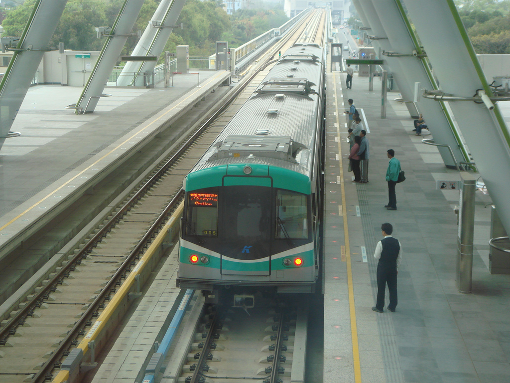
Rapid Transit
 The World Games Station of Kaohsiung MRT
A new metro system, the Kaohsiung Mass Rapid Transit opened for revenue service in March 2008. A light rail line that circles central Kaohsiung City was also approved in 2007. In 2004, the Kaohsiung City Government and Siemens built a temporary two-station circular light rail line, along with one trainset, in Central Park, in order to demonstrate the feasibility of building a light rail system in Kaohsiung City. It was meant to alleviate some residents' concerns, such as producing excessive noise and hindering normal traffic flow, that light rail would negatively impact their surroundings. This Siemens Combino vehicle was later used as part of the defunct M>Tram network in Melbourne, later transferring to Yarra Trams.
Railway
The city is served by the Taiwan Railway Administration's Western Line and Pingtung Line. Taiwan High Speed Rail also serves Kaohsiung City via its new Zuoying Station in northern Kaohsiung City. Future plans include extending high speed rail to the new Kaohsiung Station in the city centre. The new Kaohsiung Station will be an underground station, replacing the current ground level station. Additionally, these two stations will also be served by Red line of Kaohsiung Rapid Transit System when the line opened for revenue service in early 2008.
Attractions
 The Kaohsiung Confucius Temple
- Love River (愛河)
- Urban Spotlight Arcade (城市光廊)
- Tuntex Sky Tower (東帝士85國際廣場)
- World Games Stadium (世運會主場館)
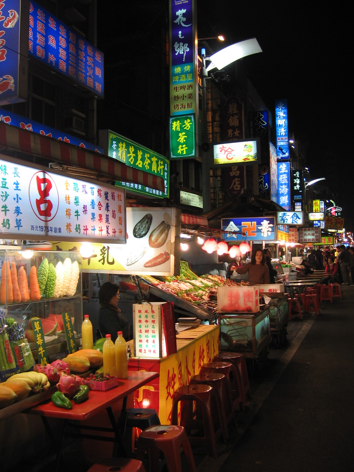
- Liuhe Night Market (六合夜市)
- Zuoying's Lotus Lake (左營蓮池潭)
- Kaohsiung Museum of Fine Arts (高雄市立美術館)
- Cihou Fort (旗後砲台)
- Qijin Ferry (旗津渡輪)
- Old City of Zuoying (鳳山舊城)
- Chai Mountain (柴山)
- Ban Ping Mountain (半屏山)
- Shou Shan Zoo (壽山動物園)
- Former British Consulate at Takao (前清英國領事館)
- Holy Rosary Cathedral (前金天主堂)
- National Science and Technology Museum (國立科學工藝博物館)
- Kaohsiung Museum of History (高雄市立歷史博物館)
- Old Kaohsiung Railway Station (台鐵舊高雄車站)
- Siziwan Scenic Area (西子灣風景區)
- Kaohsiung Astronomical Museum (高雄市立天文教育館)
- Kaohsiung Hakka Cultural Museum (高雄市客家文物館)
- Chang-Gu World Trade Center (長谷世貿大樓)
- Tower of Light (光之塔)
- Singuang Ferry Wharf (新光碼頭)
- True Love Ferry Pier (真愛碼頭)
- Kaohsiung Fisherman's Wharf (高雄港漁人碼頭)
- Sinsing Night Market (新興夜市)
Education
Kaohsiung has a number of colleges and junior colleges offering training in commerce, education, maritime technology, medicine, modern languages, nursing, and technology.
- Kaohsiung Medical University (高雄醫學大學)
- National Kaohsiung First University of Science and Technology (國立高雄第一科技大學)
- National Kaohsiung Normal University (國立高雄師範大學)
- National Kaohsiung University of Applied Sciences (國立高雄應用科技大學)
- National Kaohsiung Marine University (國立高雄海洋科技大學)
- National Kaohsiung University of Hospitality and Tourism (國立高雄餐旅大學)
- National Sun Yat-sen University (國立中山大學)
- National University of Kaohsiung (國立高雄大學)
- Wenzao Ursuline College of Languages (文藻外語學院)
- Kaohsiung Municipal Kaohsiung Senior High School (高雄市立高雄高級中學)
- Municipal Kaohsiung Girls' Senior High School (高雄市立女子高級中學)
- Kaohsiung American School (高雄美國學校)
- I-Shou International School (義大國際高級中學)
Conferences
Kaohsiung hosted the OECC (OptoElectronics and Communications Conference) in 2006 and is scheduled to host it again in 2011.
Sister cities and twin towns
Kaohsiung is twinned with the following locations.
 Brisbane, Australia
 Belize City, Belize
 Barranquilla, Colombia
 Cartago, Costa Rica
 Hachiōji, Tokyo, Japan
 Blantyre, Malawi
 Cebu, Philippines
 Durban, South Africa
 Busan, South Korea
 Colorado Springs, Colorado, United States
- Honolulu, United States
- Knoxville, Tennessee, United States
- Little Rock, Arkansas, United States
- Macon, Georgia, United States
- Miami, United States
- Mobile, Alabama, United States
- Pensacola, Florida, United States
- Plains, Georgia, United States
- Portland, Oregon, United States
- San Antonio, United States
- Seattle, United States
- Tulsa, Oklahoma, United States
 Da Nang, Vietnam
See also
- Kaohsiung City Government
- Kaohsiung City Council
- Taipei
- List of cities in the Republic of China
- Administrative divisions of the Republic of China
References
- ^ http://taiwanjournal.nat.gov.tw/ct.asp?xitem=53774&ctnode=413&mp=9
- ^ Welcome to Kaohsiung City - Statistics
- ^ What's in changing a name? Taiwan Journal Vol. XXVI No. 19 May 15, 2009 "...while name Kaohsiung is technically the Mandarin pronunciation of the Japanese written version of a Holo Taiwanese rendition of an old aboriginal name..."
- ^ "Statistics - Monthly Mean". Central Weather Bureau. http://www.cwb.gov.tw/eng/index.htm.
- ^ a b "Kaohsiung City to open solar energy industrial zone". Focus Taiwan News Channel. 2010-06-27. http://focustaiwan.tw/ShowNews/WebNews_Detail.aspx?Type=aALL&ID=201006190006. Retrieved 2010-07-09.
- ^ "Taipei City Has Second-highest Per Capita GDP in Asia: TIER | CENS.com - The Taiwan Economic News". CENS.com. 2009-03-19. http://www.cens.com.tw/cens/html/en/news/news_inner_26710.html. Retrieved 2010-07-08.
- ^ Review of Maritime Transport 2004. New York: United Nations. 2005. ISBN 92-1-112645-2.
- ^ a b Dale, Jamie (2008-01=17). "Kaohsiung container port hits full capacity". Lloyd's List Daily Commercial News (Informa Australia): p. 16.
External links
- Kaohsiung travel guide from Wikitravel
- Kaohsiung City Government official website (Chinese)
- Kaohsiung City Government official website (English)
Metropolitan areas in Taiwan Taipei–Keelung metro area • Kaohsiung metro area • Taichung–Changhua metro area • Taoyuan–Zhongli metro area • Tainan metro area • Hsinchu metro area • Chiayi metro area Administrative divisions of the Republic of China(Otherwise known as Taiwan).Special municipalities 
Taiwan Province CitiesFujian Province See also: Free Area of the Republic of China.Districts of Kaohsiung City seat: Lingya and FengshanEarlier districts 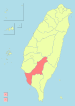
Fengshan region Gangshan region Qishan region Note: Although Hanyu Pinyin is the national standard, Tongyong Pinyin is still commonly used in Kaohsiung.Categories:- Kaohsiung
- Port cities and towns in Taiwan
- Populated places established in 1662


Wikimedia Foundation. 2010.