- Malham Tarn
-
Malham Tarn 
A view of the north-east corner of Malham Tarn 
Malham Tarn shown within North Yorkshire Location Yorkshire Dales, England Coordinates 54°05′45″N 2°10′0″W / 54.09583°N 2.166667°WCoordinates: 54°05′45″N 2°10′0″W / 54.09583°N 2.166667°W Lake type Glacial Catchment area 6 km2 (2.3 sq mi) Basin countries United Kingdom Surface area 0.62 km2 (0.24 sq mi) Average depth 2.4 m (7.9 ft) Max. depth 4.4 m (14 ft) Residence time 11 weeks Surface elevation 377 m (1,237 ft) Malham Tarn is a glacial lake near the village of Malham in the Yorkshire Dales, England. It is 377 metres (1,237 ft) above sea level, making it the highest lake in England. The lake is one of only eight upland alkaline lakes in Europe. Its geology, flora and fauna have led to it being listed under a number of conservation designations. The site is currently owned by the National Trust, who lease part of the site to the Field Studies Council who offer residential and non-residential field courses there. The site was the inspiration for Charles Kingsley's 1863 novel, The Water-Babies, A Fairy Tale for a Land Baby.
Contents
Geography
Malham Tarn is situated in the Yorkshire Dales, a national park in the Yorkshire Pennines. It lies approximately 25 miles (40 km) north-west of Bradford and about 2.5 miles (4.0 km) north of the nearest settlement, Malham.
At 377 metres (1,237 ft) above sea level it is the highest lake in England and the highest marl lake in Great Britain.[1][2] The lake is one of only eight upland alkaline lakes in Europe having a pH between 8.0 and 8.6.[2] The catchment area of the lake is 600 hectares (6.0 km2; 2.3 sq mi) and the main inflow is a stream at the lake's north-west corner.[2] The lake is 4.4 metres (14 ft) at its deepest, with an average depth of 2.4 metres (7.9 ft) and the surface area is 62 hectares (0.62 km2; 0.24 sq mi).[2] It takes approximately 11 weeks for water to leave the lake after it has entered.[3] The primary outflow is a small stream at the southern end of the lake. The outflow stream goes underground after approximately 500 metres (1,600 ft) before emerging downstream of Malham Cove as a source of the River Aire.[2]
Natural history
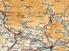 The position of Malham Tarn in the southern Yorkshire Dales
Situated in a limestone area, Malham Tarn itself mainly lies on a bed of silurian slate which is covered with marl deposits.[3] The lake's basin was dammed by a moraine at the end of the last glacial period, approximately 10,000 years ago. It used to be about twice its current size, having shrunk due to silting at the western shore; this has formed a boggy region called Tarn Moss. Following deforestation during the Iron Age, the land surrounding the lake has been used for grazing which has prevented further tree growth. An embankment and sluice gate were added to the lake in 1791 by Lord Ribblesdale;[3] this has had the effect of raising the level of the lake by approximately 1 metre (3.3 ft).[2] The average annual rainfall over the catchment area is 1,542.5 millimetres (61 in).
The lake is home to six species of fish, as well as white-clawed crayfish, Great Crested Grebes, Moorhens, Coots, Tufted Ducks and Teal.[4] A number of waders such as Redshanks, Curlews, Lapwings and Oystercatchers breed in the surrounding area. Two rare benthic copepods, Bryocamptus rhaeticus and Motatia mrazeki, are found in the lake, along with 22 species of molluscs—nine of which are found at their highest altitude in Britain.[3] The lake also contains a number of submerged aquatic plants, while the surrounding area is home to a diverse number of plants including wild cranberry, bearberry, crowberry, dark-leaved willow and Purple Moor Grass.[4]
The lake is located in the Malham and Arncliffe Site of Special Scientific Interest which was established in 1955.[2] In 1992, the lake and its wetlands were designated as a National Nature Reserve.[2] The lake was listed as a Ramsar Convention site in 1993.[5] It is also in the Craven Limestone Complex Special Area of Conservation.[6]
History
There has been human activity at Malham Tarn dating back to the Mesolithic era when the shores of the lake were used for camping during hunting trips for deer and wild cattle.[7] During the Bronze and Iron Ages, the surrounding area was settled by farmers who used the land for grazing. Following the Roman conquest of Britain the upland areas were not seen as attractive and the only Roman presence in the area was a marching camp on Malham Moor.[7] During the Medieval period the lands were owned by the Monasteries, and their use for grazing continued. A survey undertaken in 1539 at the time of the dissolution of Fountains Abbey makes note of a farmstead on the northern shore of lake.[8]
 Malham Tarn House now known as Malham Tarn Field Studies Centre
Following the dissolution of the monasteries, the estates of Malham Moor then changed hands several times until they were eventually acquired by Thomas Lister—later to become the first Lord Ribblesdale—in the mid- to late-18th century. Lister then built a hunting lodge on the site of the old farm in the 1780s. The estate was then sold to businessman James Morrison in 1852. Following Morrison's death the estates were inherited by his son, Walter, in 1857. While visiting Walter Morrison in 1858, author Charles Kingsley was inspired to write the Victorian era novel The Water-Babies, A Fairy Tale for a Land Baby.[9] Walter Morrison died in 1921 and the estate subsequently changed hands a number times before being broken up. The house and the lake were eventually bought by Walter Morrison's great-niece, Mrs Hutton-Croft, in 1928. In 1946 Mrs Hutton-Croft gifted the house to the National Trust, who manage the property and lease the house to the Field Studies Council, now called the Malham Tarn Field Studies Centre.[8]
References
- ^ "Malham Tarn and Moor". National Trust. http://www.nationaltrust.org.uk/main/w-malhamtarnmoor. Retrieved 2008-08-20.
- ^ a b c d e f g h Bradley, P. (March 2002). White-clawed Crayfish (Austropotamobius pallipes) At Craven Limestone Complex SAC, North Yorkshire. Field Studies Council. http://www.field-studies-council.org/malhamtarn/additional/Research%20Seminars/research%20seminar%202001/#foreword. Retrieved 2008-08-19.
- ^ a b c d Coletta, Pietro (2002-02-20). "Malham Tarn: an introduction". King's College London. Archived from the original on 2006-07-19. http://replay.waybackmachine.org/20060719012722/http://www.kcl.ac.uk/kis/schools/life_sciences/life_sci/malham/intro.htm. Retrieved 2008-08-20.
- ^ a b "Malham Tarn NNR". Yorkshire Dales National Park Authority. http://www.yorkshiredales.org.uk/malham_tarn_nnr.htm. Retrieved 2008-08-20.
- ^ "The Annotated Ramsar List: United Kingdom". The Ramsar Convention on Wetlands. Archived from the original on 2008-06-29. http://web.archive.org/web/20080629165637/http://www.ramsar.org/profile/profiles_uk.htm. Retrieved 2008-08-20.
- ^ "Craven Limestone Complex". National Biodiversity Network. http://www.searchnbn.net/siteInfo/siteSpeciesGroups.jsp?useIntersects=1&allDs=1&engOrd=1&srcKey=UK0014776&srcDsKey=GA000327. Retrieved 2008-08-20.
- ^ a b "Out of Oblivion: Malhamdale". Yorkshire Dales National Park Authority. http://www.outofoblivion.org.uk/malhamdale.asp. Retrieved 2008-08-20.
- ^ a b "Malham Tarn & House". KirkbyMalham.info. http://www.kirkbymalham.info/KMI/malhammoor/tarnhouse.html. Retrieved 2008-08-20.
- ^ "Inspiration for leap of imagination". Yorkshire Post. 2007-11-22. http://www.yorkshirepost.co.uk/features/Inspiration-for-leap-of-imagination.3511466.jp. Retrieved 2008-08-20.
External links
Categories:- Geography of North Yorkshire
- Lakes of England
- National Nature Reserves in England
- Ramsar sites in England
- Sites of Special Scientific Interest in North Yorkshire
- Glacial lakes


Wikimedia Foundation. 2010.