- Milton Malsor
-
Coordinates: 52°11′00″N 0°55′00″W / 52.183333°N 0.916667°W
Milton Malsor 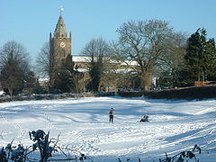
The Church at Milton Malsor, in 2004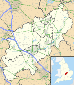
 Milton Malsor
Milton Malsor shown within NorthamptonshirePopulation 713 (2001 Census)[1]
763 (2011 est)[2]OS grid reference SP734556 - London 66 miles (106 km) Parish Milton Malsor District South Northamptonshire Shire county Northamptonshire Region East Midlands Country England Sovereign state United Kingdom Post town NORTHAMPTON Postcode district NN7 3 Dialling code 01604 Police Northamptonshire Fire Northamptonshire Ambulance East Midlands EU Parliament East Midlands UK Parliament From 2010: Daventry List of places: UK • England • Northamptonshire Milton Malsor is a village and civil parish in South Northamptonshire, England.[3] It is 4 miles (6.4 km) south of Northampton, 45 miles (72 km) south-east of Birmingham, and 66 miles (106 km) north of central London; junction 15 of the M1 motorway is 2 miles (3.2 km) east by road. The area of the Milton Malsor civil parish is 1,650 acres (670 ha), stretching from north of the M1 motorway at junction 15, south to the West Coast Main Line, east to the A508 road, and west to the A43 road.[4]
Contents
History
 The Malsoures or Malesoures family arms: party azure and gules three crescents argent[5]
The village's name is from the Old English middel for "Middle" and tun meaning farm or settlement[6] and the second part of the name appears to be from "Malsoures", the name of a prominent local family added much later. The first recorded mention of the village is in the days of William the Conqueror and the Domesday Book. This records that there were two manors and two men held lands at Milton as part of their Baronies. These were William Peverel and Goisfrid Alselin.
Governance
 War Memorial and Village Hall (behind) in snow on 29 January 2004
The village has a Parish Council[7] with nine members elected every four years (next election 2015). The Parish Council area extends to include the M1 in the north between junctions 15 and 15a; to the east the A508 Northampton to Milton Keynes main road; to the south part of the West Coast Main Line and to the west the A43 Northampton-Oxford trunk road. The local district council is that of South Northamptonshire[8] where Milton is in Harpole and Grange ward together with the villages of Gayton, Rothersthorpe, Harpole and Kislingbury which elects two members. The Northamptonshire County Council[3] division has one member (Conservative).
The Member of Parliament from 2010 is Mr Chris Heaton-Harris, Conservative, for the Daventry Parliamentary Constituency. Prior to the 2010 General Election the village was in Northampton South Parliamentary Constituency. Initially the Boundary Commission wanted to move the village into the new parliamentary constituency of South Northamptonshire. However, as this was inconvenient for election administration purposes, the Boundary Commission put Milton with fellow ward villages in South Northants Council's "Harpole and Grange"[8] ward into the Daventry Constituency previously held by Mr Tim Boswell who stood down at 2010 General Election.[9]
Geography
 Flooding in 'The Dip' in 1998
Many fields around the village reflect England's history. The field known as 'the Leys' (opposite Milton House in Rectory Lane) shows clear signs of 18th century pre-enclosure and pre-British Agricultural Revolution farming in strips. The mediaeval open field system was enclosed in Milton in 1779 together with that of Collingtree.[10] The soil is predominantly sandy as one might expect since the area is the bed of an ancient river. Evidence of sand and clay extraction is all around, reflecting 19th and 20th century industrial and urban expansion. For example, the small industrial estate in Gayton Road is on an old clay quarry; the playing and football fields in Collingtree Road are on the sites of sand quarries - in the latter case mostly filled with clay spoil from the 1950s construction of the M1. The field between Towcester Road and the A43 Milton by-pass, which opened in May 1991,[11] to the west of the village was also the site of a sand quarry in the 1950s and 1960s.
In 1965 the driver of a mechanical digger spotted a shiny object in a newly exposed face. It turned out to be an early Bronze Age Cinerary Urn. The field between the village and the M1 on the north side of Collingtree Road is an area designated by Northamptonshire County Council[3] for sand extraction. The sand is stated by the county council to be of the 'soft sand' type suitable for mortar. The site is in Milton Malsor parish and only ca.200m from houses in the village. It was originally called the "Collingtree site" but the county council finally referred to it as the Milton site in late 2008. It has so far not been developed probably due to its triangular shape and stranded location between the motorway along one edge, the railway line another and a road unsuited to heavy lorries on the third. The site is included in the county council's mineral's and waste plan, the subject of a Public Inquiry in 2009.[12] A third Public Inquiry in 2010 retained the site.
A stream runs northwest through the village, partly in a conduit but visible from Collingtree Road and Rectory Lane as it flows north through the field known as 'The Dip' after an old sheep dip the remains of which are still visible. In Spring 1998 this flooded, causing minor damage to some houses. The stream flows north joining with others from the east and south flowing south and west around Hunsbury Hill. It then joins the River Nene at Upton, west of Northampton. The Grand Union Canal and its Northampton arm, built in 1815 passes nearby. There is a marina just off the road to Gayton. There are 17 locks on the arm, taking the canal downhill into Northampton and to join the River Nene east of the town. It takes about two hours for a boat to travel through.
Demography
The United Kingdom Census 2001[1] showed there were 713 people living in the village, 344 male, 369 female, with average age 45.21 years (the 2011 estimated population is 763[2]). There were 302 dwellings, 280 of them with central heating and 218 being owner occupied. The United Kingdom Census 2011 is expected to show a 10% increase in people and houses. The surrounding South Northamptonshire district is rural and sparsely populated with just over 80,000 people in 2000.[13]
New development within the village boundary is restricted to infill development only. A new housing development of 14 houses was completed in Chestnut Close in 2008. Smaller ones of 6 dwellings was begun in 2010 for the derelict Home Farm site off Malzor Lane and one or two others elsewhere. Also in 2010 a proposal for 25 houses for a site off Stockwell Way was opposed by the parish council and refused by the district council as it was outside the village boundary and contrary to district council adopted policy. Planning details can be accessed via the parish council website.[7] Possible urban extensions to Northampton were proposed in 2007 by the West Northamptonshire Joint Planning Unit, a group formed by Northampton Borough Council, South Northamptonshire District Council and Daventry District Council. These proposals included extensions on land in the parish between the M1 motorway, north of the village, A43 by-pass (west), A508 trunk road (east) and the West Coast main railway line to the south. A parkway station south the village was also mentioned but train operators do not want further stops on the line between London and Rugby via Northampton. Possible expansion of Northampton south of the M1 affecting the village were excluded from draft proposals published for consulation in July 2009.
Economy
 Milton postbox with the insignia of Queen Elizabeth II
There are two pubs: "The Greyhound"[14] in Towcester Road, which has a large restaurant, and "The Compass" in Green Street, a more traditional village pub also offering bar food. The Greyhound is adjacent to the Village Hall and attracts large crowds from Northampton's southern suburbs in summer as it has a large garden area. Both establishments serve good quality real ale with periodic guest bitters.
Milton Malsor has a retirement care home for the elderly in Green Street called Holly House. Sheltered housing for older people in the form of 26 flats and bungalows is also provided in the village by South Northants Homes Ltd.[15] The area is centred around Raynsford House which offers a lounge, dining room, laundry, guest facilities and a community alarm service for sheltered housing residents.
A shop and former post office and the modern village hall, refurbished in 2008, are both in the High Street opposite the green and War Memorial. The Northampton Hilton Hotel is approximately 1½ miles distant on Watering Lane in the neighbouring village of Collingtree, just off the A45 trunk road. There are several other hotels in the area along the A45 trunk road.
The village has two small industrial estates; the larger on Gayton Road is adjacent, but with no access, to the A43. This is referred to locally as 'Gallifords' reflecting its ownership. The smaller is adjacent to the M1 bridge along Collingtree Road and known as 'Maple Farm' alluding to its history. There is an architect's office in the old Rectory and additional modern offices on Towcester Road in the converted Hope Brewery and out buildings.
A mobile library visits the village every two weeks; the nearest local library is at Hunsbury, about a mile north, next to a large Tesco 'Xtra' supermarket and petrol station.
There are three working farms in the parish including a free-range egg farm.
Landmarks
 Plaques at the Manor House in Rectory Lane where James Harrington, author of Oceana lived and the Baptist Chapel in Green Street founded 1827.
Much of the village is in a conservation area which is shown on a map on the Parish Council website[7] and has many traditional Northamptonshire stone cottages, a large number of which have thatched or pantiled roofs. There are over 30 listed buildings in the village,[16] most, but not all, in the conservation area. Particular buildings of note, mostly listed by their street locations, are as follows:
- Rectory Lane, formerly Pluck's Lane
- Milton House (early 18th century) and Manor Cottage (1777), Grade II listed. The house has a doorway with Tuscan columns[17][a]
- Mortimers[a], Grade II listed, early 18th century[18] earlier than Milton House,[17] which was named after a family who lived there and originally owned by the Hospital of St John at the bottom of Bridge Street in Northampton.[19] The house and its grounds were auctioned on 17 March 2011[18] fetching a total of £1,115,000, but with the house requiring substantial refurbishment. According to the local paper[20] the house was once lived-in by Revd Samuel Wigg the founder of Northampton Saints Rugby Football Club. The house was last sold in 1921, and last lived in by Margaret Alexander, granddaughter of Wigg.
- Milton Malsor Manor, Grade II listed, 16th century,[21] James Harrington, the author of the controversial book "The Commonwealth of Oceana", published 1656, was a former occupant [22] and the building has a blue plaque in recognition, installed on 4 October 2008
- The Old Rectory[b], now used as architects offices
- Collingtree Road
- Church of the Holy Cross, Church of England, 12th century origins but most late 13th to mid 14th century,.[17] The church has a crenellated tower, and later battlements and pinnacles. There are monuments to Mrs Sapcotes Harington, d.1619, and Richard Dodwell, d.1726
- The Grange[c]
- Green Street
- Baptist Chapel, 1827, founded by Thomas Marriott (b.Denton 1789 d.Milton 14 June 1876) and buried in the churchyard of the chapel).[23]
- The Manse[c] (next to the chapel), residence of Marriott as Pastor
- Milton Parochial Primary School
- Welstead Farm House[c]
- The Old Bakehouse[c]
- The Compass Public House
- Malzor Lane
- Milton Manor House[c] not to be confused with The Manor in Rectory Lane. Nick Raynsford, Labour Party MP for Greenwich was brought up here.[24] The house has a notable 17th century staircase with acanthus scrolls similar to work at Lamport Hall and Castle Ashby[17]
- High Street
- Towcester Road
- The Greyhound Public House
- The former Hope Brewery, now converted to offices. In 1892 Phipps Northampton Brewery Company acquired the business from East Brothers. In 1906 NBC it was closed moving production to Northampton, Bridge Street, now the site of the Carlsberg brewery[25]
- The Counties Crematorium, erroneously referred to as being in Milton, is now actually outside the parish about a mile north of the village and north of the M1 in West Hunsbury, Northampton with the Northampton borough postcode NN4 9RN
- Notes
- a There are good views from the public footpath across the field known as "The Leys" in Rectory Lane.
- b Private property - view of rear garden shown with permission
- c Private property - not open to the public
- Public footpaths in the village are clearly marked by green fingerposts. Dog fouling throughout the parish, including footpaths, is strictly prohibited with heavy fines for infringement.
Transport
The county of Northants is at a north-south and east-west rail, motorway and fast road transport network. The Northampton Loop of the West Coast Main Line carries trains from Northampton to London Euston and runs through the parish just east of the village, with the main line about a mile south. The nearest convenient stations are at Northampton (4 miles north), Milton Keynes Central (14 miles south) and also Wellingborough (12 miles east) on the Midland Main Line with links to Sheffield, Leicester and St Pancras International.
Typical travel times in minutes by road (peak times in italics) are: central London 75 (110), Birmingham 45 (60), Manchester 120 (175), Leicester 50 (65), Oxford 50 (60), Cambridge 85 (130), Milton Keynes 20 (30). Travel times (peak) by rail (from April 2008) by Govia London Midland - formerly Silverlink County - as well as Virgin Trains services in minutes are: from Northampton to Central London 65, to Birmingham 65; from Milton Keynes to Central London 40 and Manchester 120. Airports at Heathrow, Gatwick, and London Stansted as well as Birmingham Airport, Luton Airport and East Midlands are all within easy reach. The village has a bus service to Northampton, Towcester and Milton Keynes, though this is poor on Sundays and weekday evenings.
1967 and 1969 railway accidents
On Tuesday, 18 April 1967 at about 2.31pm, a wagon on a goods train of 69 empty mineral wagons, travelling on the down line to Northampton, derailed just south of the village. The train travelled a further 1½ miles before more wagons derailed, a little distance north of the village playing field. Some of the wagons went towards the up line from Northampton to London and were hit by a four-coach passenger train at about 70 mph. Although the brakes of the passenger train had been fully applied, two coaches were derailed with one falling onto its side. All 45 passengers and train crew were evacuated fairly promptly. Of these, 21 were injured but only two were detained at Northampton General Hospital. The driver of the passenger train was seriously injured but both he and the passenger detained overnight made a good recovery.
The inspector's report[26] on the incident states that "...assistance was given by the residents of the nearby village of Milton Malsor and I am informed that members of the Women's Institute of this village were quick to organise refreshment for those involved in the accident and their rescuers". The Inspector concluded that the accident resulted from a broken spring on the goods train.
A similar accident occurred on 31 December 1969 but about a mile further south near the northern end of Roade cutting, with the driver of the passenger train involved sadly killed on this occasion.[27]
Education
Milton Parochial Primary School in Green Street had 110 pupils in 2007, a large proportion of which were from the southern area of Northampton such as Hunsbury.[28] The most recent Ofsted inspection, published 4 November 2010 stated: This is a good school. The pupils make good progress and achieve well because the teaching is effective.[29] Crazy 4 Kids After School and Holiday Club is privately owned located in the grounds of the Primary School. Children have access to the school hall, adjoining quiet room and a secure outdoor play area. The club is open each weekday from 3.30pm to 6pm and from 8am to 6pm during the school holidays. The most recent Ofsted report on the club states that: Overall the quality of the provision is good.[30] The village is in the catchment area of Campion Secondary School at Bugbrooke, about 6 miles (10 km) away by road with the children bussed daily.
Religion
There is a church, dedicated to the Holy Cross in Collingtree Road which has its own Parochial Church Council and is part of the Church of England's Peterborough Diocese. Prior to 2009 the church was part of the "Three Parishes Group"[31] together with the churches of the nearby villages of Collingtree and Courteenhall. Since 2010 it has been re-grouped with four other parishes including Blisworth and Stoke Bruerne. There is also a Baptist Chapel in Green Street. A joint church newsletter is delivered monthly.[31]
Culture and community
 The Old Rectory from the rear garden with permission 18 July 2007
The village has an active number of social and other groups including a Women's Institute which meets monthly; a village football club, Milton FC[32] with its own village team which takes an active part in the Travis Perkins Northamptonshire Combination; indoor bowls and badminton groups both meet regularly in the village hall; village historical society with regular meetings about local matters of esoteric and general interest; an art club meets at the village hall during school term time. The village has a Scouts group, 1st Collingtree and Milton Malsor Scouts, and Brownies group which meet at the village hall during school term time.
References
Footnotes
- ^ a b "UK census 2001 - data". http://neighbourhood.statistics.gov.uk/dissemination/LeadAreaSearch.do?a=3&r=1&i=1001&m=0&s=1219926362128&enc=1&areaSearchText=NN7+3AQ&areaSearchType=16&extendedList=true&searchAreas=Search. Retrieved 28 August 2008.
- ^ a b SNC (2011). South Northamptonshire Council Year Book 2011-2012. Towcester NN12 7FA. pp. 39.
- ^ a b c "Northamptonshire County Council website". http://www.northamptonshire.gov.uk/. Retrieved 11 October 2008.
- ^ Parish map
- ^ "British History on Line from "A History of the County of Northampton" vol 4, 1937". http://www.british-history.ac.uk/report.aspx?compid=66366. Retrieved 1 November 2008.
- ^ Nottingham University guide to English place names, accessed 7 April 2010
- ^ a b c "Milton Malsor Parish Council website - newsletters, planning, maps, facilities, local police links and link to a 3-D satellite view". http://www.miltonmalsorparishcouncil.org.uk/. Retrieved 28 August 2008.
- ^ a b "South Northants Council website". http://www.southnorthants.gov.uk/. Retrieved 7 October 2008.
- ^ "UK Polling Report". http://ukpollingreport.co.uk/guide/seat-profiles/daventry. Retrieved 13 April 2008.
- ^ "Northampton Borough Council: Collingtree Conservation area appraisal - May 2008". http://www.northampton.gov.uk/downloads/CollingtreeAppraisal-Final.pdf. Retrieved 12 March 2010.
- ^ "A43 by-pass history and final construction". http://www.blisworth.org.uk/images/Bypass%20History.htm. Retrieved 8 November 2009.
- ^ "Northamptonshire County Council website - Minerals and Waste Development Framework (MWDF) Public Examinations 2009". http://www.northamptonshire.gov.uk/en/councilservices/Environ/planning/mwdf/Pages/default.aspx. Retrieved 7 June 2009.
- ^ "A Vision of Britain - extensive local statistical data". http://www.visionofbritain.org.uk/GBH_match_page.jsp?ons=South%20Northamptonshire. Retrieved 19 January 2008.
- ^ "The Greyhound pub and restaurant". http://www.pub-explorer.com/nhants/pub/greyhoundmiltonmalsor.htm. Retrieved 19 December 2008.
- ^ "Sheltered Housing for older people in the UK". http://www.housingcare.org/sheltered-housing/scheme-7650-raynsford-house-milton-malsor-england.aspx. Retrieved 9 July 2008.
- ^ Listed Buildings in the village, accessed 5 November 2010
- ^ a b c d e Pevsner, Nikolaus; Cherry, Bridget (revision) (1961). The Buildings of England – Northamptonshire. London and New Haven: Yale University Press. pp. 306–7. ISBN 978-0-300-09632-3.
- ^ a b "Country bargains: Could this be the buy of a lifetime? A period house frozen in time may be the perfect country gem, finds Maria Fitzpatrick" Sunday Telegraph 15 March 2011
- ^ "The Story of Milton Malzor sic", Revd B Edward Evans, MA, Rector, ISBN 1 85598 026 6, first published 1924 as a subscribers edition by Wells Gardner, Darton & Co Ltd, 3 & 4 Paternoster Bldgs, London EC4 (destroyed in the Blitz). Facsimile reprint 1997 by MCB University Press Ltd, 60-62 Toller Lane, Bradford, West Yorkshire BD8 9BY as a subscribers edition of 500 copies
- ^ "Saints’ founder’s home up for sale" Northampton Chronicle & Echo 19 March 2011
- ^ "The Manor in Rectory Lane". http://www.prestoungrange.org/prestoungrange/html/milton_malsor/milton_malsor.html. Retrieved 9 February 2008.
- ^ "Milton Malsor Historical Society - History Trail". Archived from the original on 14 December 2007. http://web.archive.org/web/20071214160942/http://www.miltonmalsorhistory.org.uk/history_trail/. Retrieved 14 February 2008.
- ^ Marks, Peter (2006). Thomas Marriott and the Baptists of Milton Malsor. Milton Malsor, Northampton, England: Milton Malsor Historical Society.
- ^ "Andrew Roth's Parliamentary Profiles in The Guardian". London. 20 March 2001. http://www.guardian.co.uk/politics/2001/mar/20/profiles.parliament4. Retrieved 7 September 2008.
- ^ "Phipps Northampton Brewery Company Office site - history". http://phipps-nbc.co.uk/2.html. Retrieved 25 February 2010.
- ^ "Ministry of Transport Inspector's report of the rail accident of 18 April 1967 including diagram showing location of the accident". http://www.railwaysarchive.co.uk/documents/MoT_Roade1967.pdf. Retrieved 17 July 2009.
- ^ Report on the Derailment and subsequent Collision that occurred on 31st December 1969 near Roade Junction - official report of the 1969 railway accident, accessed 23 July 2011
- ^ Milton Malsor Parochial Primary School at Northamptonshire County Council website. Retrieved on 2 May 2010
- ^ Milton Parochial Primary School, Ofsted report published 4 November 2011, accessed 13 November 2011
- ^ After School and Holiday Club, Ofsted report published 29 July 2010, accessed 13 November 2011
- ^ a b "The Three Parishes Group - Milton, Collingtree and Courteenhall". http://www.threeparishes.org.uk/. Retrieved 19 January 2008.
- ^ "Milton FC website, includes results, fixtures and tables". http://www.miltonfc.co.uk. Retrieved 22 November 2008.
Further reading
- "The Story of Milton Malzor" sic, Revd B Edward Evans, MA, Rector. See reference to electronic copy in footnotes.
- "Swim Ginger", Revd Malcolm Deacon, ISBN 0 9523188 2 2, recollections, 1940–2005, of a resident and United Reformed Church Minister.
- "Milton Malsor - History Revisited", Alan Digby, an extensive pictorial history of the village in the 20th century by a resident born and bred in the village. Includes sections on World Wars I and II including some curious archives of the village Home Guard during 1939-1945. Also contains a picture of the Milton Bronze Age Cinerary Urn recovered in 1965 and referred to above.
- Sundry papers referred to and published by the Historical Society - see reference above. Some of the publications referred to above are available from the society.
External links
 Media related to Milton Malsor at Wikimedia Commons
- Milton Malsor Historical Society
- The late Rev George Hubbard, Rector in the late 1950s, early 1960s Old pictures of the village including church and Rectory from his old family photo album
- Pictures of a 'Living Nativity' Event held in the village in December 2003 and broadcast live on BBC Radio Northampton
Categories:- Villages in Northamptonshire
- Rectory Lane, formerly Pluck's Lane


Wikimedia Foundation. 2010.