- Chanhassen, Minnesota
-
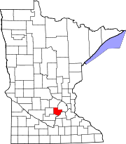
Chanhassen, Minnesota — City — Location in Carver County and the state of Minnesota.
Coordinates: 44°51′44″N 93°31′50″W / 44.86222°N 93.53056°WCoordinates: 44°51′44″N 93°31′50″W / 44.86222°N 93.53056°W Country United States State Minnesota Counties Carver, Hennepin Government - Mayor Tom Furlong Area - Total 22.9 sq mi (59.3 km2) - Land 20.8 sq mi (53.8 km2) - Water 2.1 sq mi (5.5 km2) Elevation 974 ft (295 m) Population (2010)[1] - Total 22,952 - Density 1,147/sq mi (444/km2) Time zone CST (UTC-6) - Summer (DST) CDT (UTC-5) ZIP code 55317 Area code(s) 952 FIPS code 27-10918[2] GNIS feature ID 0641106[3] Website www.ci.chanhassen.mn.us Chanhassen is a city in Carver and Hennepin counties in the U.S. state of Minnesota. It is southwest of Minneapolis. The population was 22,952 at the 2010 census.[1]
The origin of the name comes from the Dakota word chanhasen meaning "sugar-maple tree" (chan, tree; haza, a tree with sap). The northern metro area Hassan Township carries the latter syllable of the word to avoid confusion.[4] Chanhassen was ranked as the #2 best place to live in America in 2009 by Money Magazine.[5]
Contents
Geography
Chanhassen is located at 44°51′44″N 93°31′50″W / 44.86222°N 93.53056°W
According to the United States Census Bureau, the city has a total area of 22.9 square miles (59.3 km²), of which, 20.8 square miles (53.8 km²) of it is land and 2.1 square miles (5.5 km²) of it (9.26%) is water. Although the bulk of Chanhassen is in Carver County, a small portion also extends into Hennepin County.
U.S. Route 212 and Minnesota State Highways 5 and 41 are three of the main routes in the city.
Township 116 North, Range 23 West, Fifth Principal Meridian of the Public Land Survey System.
Climate
Climate data for Chanhassen, MN Month Jan Feb Mar Apr May Jun Jul Aug Sep Oct Nov Dec Year Average high °F (°C) 24
(−4)31
(−1)43
(6)60
(16)74
(23)83
(28)86
(30)83
(28)75
(24)62
(17)42
(6)28
(−2)57.6
(14.2)Average low °F (°C) 3
(−16)10
(−12)23
(−5)36
(2)48
(9)57
(14)62
(17)60
(16)51
(11)39
(4)25
(−4)11
(−12)35.4
(1.9)Precipitation inches (mm) 0.93
(23.6)0.62
(15.7)1.77
(45)2.40
(61)3.65
(92.7)4.21
(106.9)4.43
(112.5)4.48
(113.8)2.97
(75.4)2.14
(54.4)2.00
(50.8)0.84
(21.3)30.44
(773.2)Source: The Weather Channel[6] Demographics
Historical populations Census Pop. %± 1900 175 — 1910 164 −6.3% 1920 129 −21.3% 1930 128 −0.8% 1940 132 3.1% 1950 182 37.9% 1960 244 34.1% 1970 4,879 1,899.6% 1980 6,359 30.3% 1990 11,732 84.5% 2000 20,321 73.2% 2010 22,952 12.9% U.S. Decennial Census As of the census[2] of 2000, there were 20,321 people, 6,914 households, and 5,524 families residing in the city. The population density was 978.1 people per square mile (377.6/km²). There were 7,013 housing units at an average density of 337.6 per square mile (130.3/km²). The racial makeup of the city was 94.90% White, 0.75% African American, 0.15% Native American, 2.83% Asian, 0.41% from other races, and 0.95% from two or more races. Hispanic or Latino of any race were 1.98% of the population.
There were 6,914 households out of which 51.1% had children under the age of 18 living with them, 71.2% were married couples living together, 6.2% had a female householder with no husband present, and 20.1% were non-families. 15.7% of all households were made up of individuals and 3.0% had someone living alone who was 65 years of age or older. The average household size was 2.94 and the average family size was 3.33.
In the city the population was spread out with 34.6% under the age of 18, 4.4% from 18 to 24, 37.0% from 25 to 44, 19.5% from 45 to 64, and 4.5% who were 65 years of age or older. The median age was 34 years. For every 100 females there were 100.5 males. For every 100 females age 18 and over, there were 97.3 males.
According to a 2007 estimate,[citation needed] the median income for a household in the city was $92,869, and the median income for a family was $107,075. Males had a median income of $62,112 versus $38,821 for females. The per capita income for the city was $36,008. About 1.4% of families and 1.9% of the population were below the poverty line, including 2.2% of those under age 18 and 2.2% of those age 65 or over.
Points of interest
Chanhassen is home to several attractions that are well-recognized throughout the state and even nationally.
- Minnesota Landscape Arboretum
- Chanhassen Dinner Theatres
- Paisley Park Studios
- Eckankar Spiritual Campus
Chanhassen Dinner Theatres
Chanhassen Dinner Theatres is the nation's largest professional dinner theatre, and the largest privately owned restaurant in the state of Minnesota. Since 1968, more than 200 plays have been produced and played to more than ten million guests.[7]
Education
Chanhassen is split between three school districts. Most of the city is in District 112 (Chaska School District), with most Chanhassen students attending Chanhassen High School, Chaska Middle School West, Chanhassen Elementary, and Bluff Creek Elementary. Northern sections of Chanhassen are a part of District 276 (Minnetonka School District), with most Chanhassen students attending Minnetonka High School, Minnetonka Middle School East, Clear Springs Elementary, and Scenic Heights Elementary. Extreme eastern Chanhassen is a part of District 272 (Eden Prairie School District).[8] Also, some students attend public schools in other school districts chosen by their families under Minnesota's open enrollment statute.[9] Chapel Hill Academy and St. Hubert School are private institutions located in downtown Chanhassen.
Politics
Chanhassen is located in Minnesota's 2nd congressional district, represented by John Kline, a Republican, scoring 2.8% progressive on a range of issues[10] and 88% conservative based on 2006 House votes.[11]
President George W. Bush was the first sitting United States president to visit Chanhassen. He held a rally on October 9, 2004 at Chanhassen's City Center Park during the United States presidential elections of 2004.[12]
Economy
Snap Fitness and Life Time Fitness are based in Chanhassen.
Top Employers
According to the City's 2009 Comprehensive Annual Financial Report,[13] the top employers in the city are:
# Employer # of Employees 1 Rosemount Inc. 1,600 2 Life Time Fitness 1,061 3 IWCO Direct 847 4 SuperValu 528 5 General Mills 475 6 RR Donnelley 360 7 Chanhassen Dinner Theatres 300 8 Minnesota Landscape Arboretum 230 9 Byerly's 190 10 Target 147 11 Automated Building Components 123 Recreation
The City of Chanhassen places a strong emphasis on parks, open space, trails and recreation.
Beaches
Chanhassen has six public beaches.[14]
- Lake Ann Beach (Lake Ann)
- Greenwood Shores Beach (Lake Ann)
- Minnewashta Regional Park (Lake Minnewashta)
- Roundhouse Park Beach (Lake Minnewashta)
- Carver Beach (Lotus Lake)
- Lake Susan Beach (Lake Susan)
Trails
Chanhassen prides itself on providing a comprehensive, multipurpose trail system. The city has built and maintains 70 miles of trails.[15] Many of the city’s trails are located in natural resource corridors.
Skate Park
The Chanhassen Skate Park was installed in September 1999.[16] The park is located between City Hall and the downtown fire station. It features a wedge, quarter pipe, half pipe, hotbox, spine and grind rails.
Sports
Many youth sports programs are offered through the Chanhassen Athletic Association, including Baseball, Softball, Basketball, and Soccer.[17]
Chanhassen is also home to the Chanhassen Red Birds amateur baseball team.[18]
Fishing
Several well-producing lakes in Chanhassen keep the sportsmen busy year-round with fishing during the warm months and ice fishing when the lakes freeze-over. Both Lake Minnewashta and Lake Ann contain large and aggressive northern pike for the adept anglers.
Media
The Chanhassen Villager is the city’s official weekly newspaper.
Fame
Prince previously owned two homes in Chanhassen.[19] He still owns seven properties, establishing the musician as one of the city’s largest property owners.[20]
The New Age religious movement, Eckankar, is based in Chanhassen.
Notable natives and residents
- Jared Allen, NFL player for the Minnesota Vikings, lives in Chanhassen.
- Tony Denman, actor, grew up in Chanhassen.[21]
- Larry Graham, Bass guitarist and inventor of the slap bass technique on bass guitar.
- Dave Huffman, Former NFL player for the Minnesota Vikings, and former Park & Recreation commissioner lived in Chanhassen.
- Kris Humphries, Former NBA player for the New Jersey Nets, has a home in Chanhassen.
- Jim Lord, Minnesota State Treasurer
- Miles Lord, United States District Court judge
- Tim Mattran, NFL player for the Oakland Raiders, grew up in Chanhassen.
- John L. Nelson, jazz musician and father of rock musician Prince, lived in Chanhassen.
- Rep. Erik Paulsen, currently representing Minnesota's 3rd congressional district in the United States House of Representatives, businessman, grew up in Chanhassen.
- Dave Ryan, radio dj, morning show host for radio station KDWB-FM.
- Jim Thome, MLB Designated Hitter for the Minnesota Twins, lives in Chanhassen.
- Debbie Turner, actress, lives in Chanhassen.
Economy
Companies with headquarters in Chanhassen include:[citation needed]
- AmericInn
- Life Time Fitness
- Snap Fitness
Supervalu has its western satellite of the corporate headquarters in Chanhassen.[22]
References
- ^ a b "2010 Census Redistricting Data (Public Law 94-171) Summary File". American FactFinder. U.S. Census Bureau, 2010 Census. http://factfinder2.census.gov/faces/tableservices/jsf/pages/productview.xhtml?pid=DEC_10_PL_GCTPL2.ST13&prodType=table. Retrieved 23 April 2011.
- ^ a b "American FactFinder". United States Census Bureau. http://factfinder.census.gov. Retrieved 2008-01-31.
- ^ "US Board on Geographic Names". United States Geological Survey. 2007-10-25. http://geonames.usgs.gov. Retrieved 2008-01-31.
- ^ By Warren Upham, Patricia C. (2001). Minnesota Place Names: A Geographical Encyclopedia. Minnesota Historical Society Press. ISBN 0873513967.
- ^ "Best Place to Live 2009". CNN. http://money.cnn.com/magazines/moneymag/bplive/2009/top100/.
- ^ "Monthly Averages for Chanhassen, MN". The Weather Channel. 2010. http://www.weather.com/weather/wxclimatology/monthly/USMN0135. Retrieved 2010-03-26.
- ^ Chanhassen Dinner Theater
- ^ "Minnesota School Districts". Minnesota Department of Education. http://www.mnplan.state.mn.us/maps/SchoolDistricts. Retrieved 26 April 2011.
- ^ "Open Enrollment". Minnesota Department of Education. http://education.state.mn.us/mde/Academic_Excellence/School_Choice/Public_School_Choice/Open_Enrollment/index.html. Retrieved 19 November 2010.
- ^ Grossman, Joshua. "ProgressivePunch Leading with the Left". All Issues. ProgressivePunch. http://www.progressivepunch.org/members.jsp?member=MN2. Retrieved 2007-09-08.
- ^ "ACU Ratings of Congress, 2006". American Conservative Union. 2006. Archived from the original on 2007-09-03. http://web.archive.org/web/20070903043949/http://www.acuratings.org/2006all.htm#MN. Retrieved 2007-09-08.
- ^ Bush, George. "2004 Presidential Campaign Blog". http://blog.4president.us/2004/george_w_bush/page/2/. Retrieved 2009-05-01.
- ^ City of Chanhassen CAFR
- ^ City of Chanhassen: Beaches
- ^ City of Chanhassen: Trails
- ^ City of Chanhassen: Skate Park
- ^ http://www.chanhassenathleticassociation.com/%7CCAA Website
- ^ http://www.ballcharts.com/chanredbirds/%7CChanhassen Red Birds Website
- ^ Johnson, Cheryl (November 8, 2005). "Prince demolishes his Chanhassen house". Star Tribune: pp. 4B
- ^ Walsh, Paul and Lynn Smith, Mary (March 25, 2010), “Prince told to rock his way down to the tax office,” Star Tribune
- ^ Olson, Mark (December 20, 2006), "Homegrown movies,” Chaska Herald
- ^ "Directory." Supervalu. Retrieved on July 22, 2010.
External links
Municipalities and communities of Carver County, Minnesota County seat: Chaska Cities Carver | Chanhassen‡ | Chaska | Cologne | Hamburg | Mayer | New Germany | Norwood Young America | Victoria | Waconia | Watertown
Townships Benton | Camden | Dahlgren | Hancock | Hollywood | Laketown | San Francisco | Waconia | Watertown | Young America
Unincorporated
communityGotha
Ghost town Footnotes ‡This populated place also has portions in an adjacent county or counties
Municipalities and communities of Hennepin County, Minnesota County seat: Minneapolis Cities Bloomington | Brooklyn Center | Brooklyn Park | Champlin | Chanhassen‡ | Corcoran | Crystal | Dayton‡ | Deephaven | Eden Prairie | Edina | Excelsior | Golden Valley | Greenfield | Greenwood | Hanover‡ | Hopkins | Independence | Long Lake | Loretto | Maple Grove | Maple Plain | Medicine Lake | Medina | Minneapolis | Minnetonka | Minnetonka Beach | Minnetrista | Mound | New Hope | Orono | Osseo | Plymouth | Richfield | Robbinsdale | Rockford‡ | Rogers | Shorewood | Spring Park | St. Anthony‡ | St. Bonifacius | St. Louis Park | Tonka Bay | Wayzata | Woodland
Township Unorganized
territoryFootnotes ‡This populated place also has portions in an adjacent county or counties
Categories:- Populated places in Carver County, Minnesota
- Populated places in Hennepin County, Minnesota
- Cities in Minnesota


Wikimedia Foundation. 2010.