- Minute Man National Historical Park
-
Minute Man National Historical Park 

Location Middlesex County, Massachusetts, USA Nearest city Lexington, Massachusetts Coordinates 42°27′11″N 71°17′55″W / 42.45306°N 71.29861°WCoordinates: 42°27′11″N 71°17′55″W / 42.45306°N 71.29861°W Area 967 acres (3.9 km2) Established September 21, 1959 Visitors 1,027,033 (in 2005) Governing body National Park Service 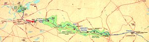 Map of the Minute Man National Historical Park.
Not to be confused with Minuteman Missile National Historic Site.
Minute Man National Historical Park commemorates the opening battle in the American Revolutionary War. It also includes The Wayside, home in turn to three noted American authors. The National Historical Park is under the jurisdiction of the National Park Service and protects 970 acres (3.9 km2) in and around the towns of Lexington, Massachusetts, Lincoln, Massachusetts, and Concord, Massachusetts.
Contents
Sites
These sites include:
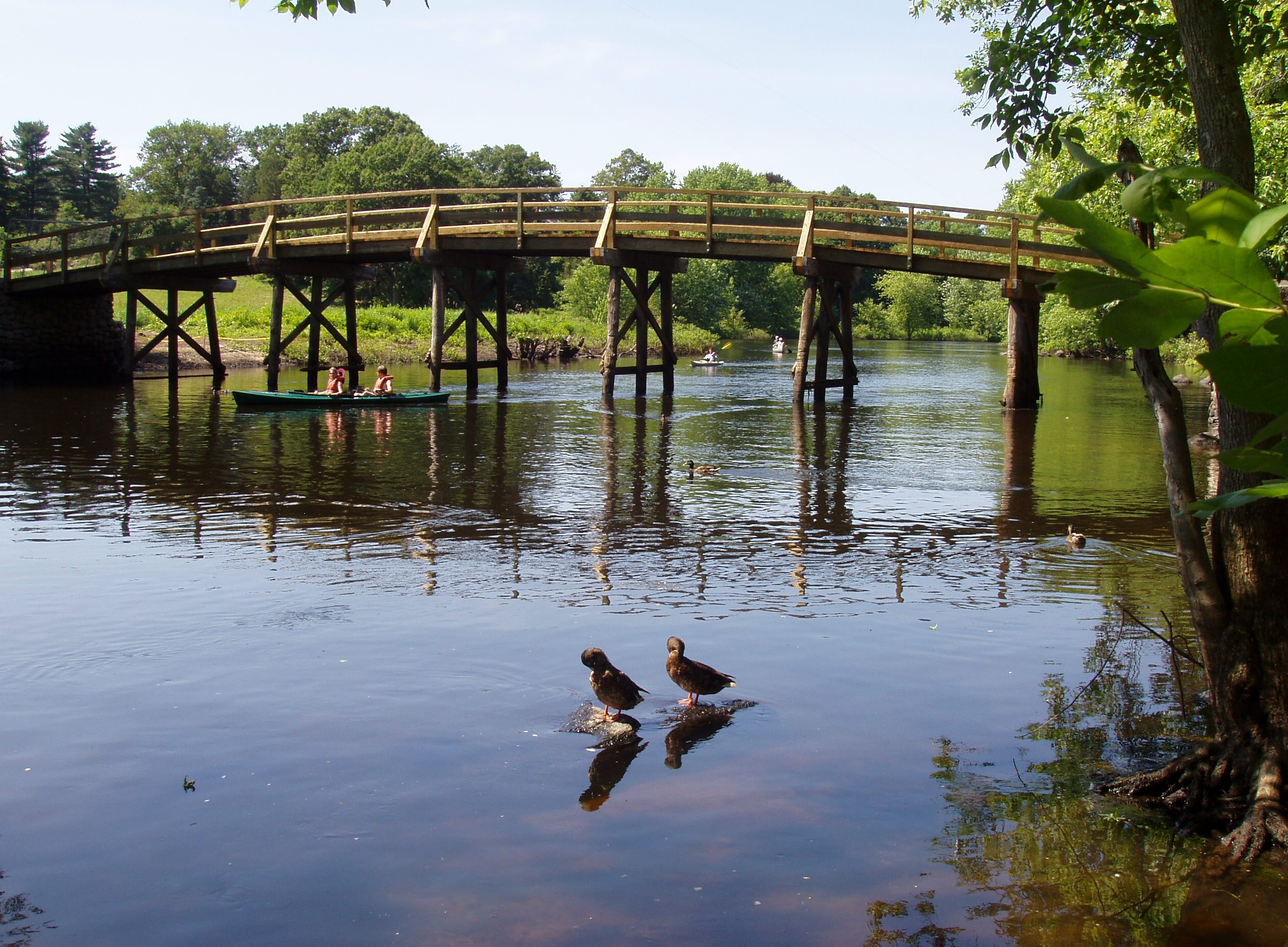
- Concord's North Bridge, where on April 19, 1775, colonial commanders ordered militia men to fire back at British troops for the first time. British colonial militia and minutemen killed three regular army soldiers and wounded eight at the North Bridge Fight. This was the second battle of the day, after the brief fight at dawn on Lexington Common. In his 1837 poem, "The Concord Hymn", Concordian thinker and author Ralph Waldo Emerson immortalized the North Bridge Fight as "the shot heard round the world". At this site also stands Daniel Chester French's well-known Minute Man Statue of 1875.[1] Across the North Bridge, opposite the Minute Man Statue is the Obelisk Monument. The Obelisk is believed to be the country's first memorial to its war casualties.
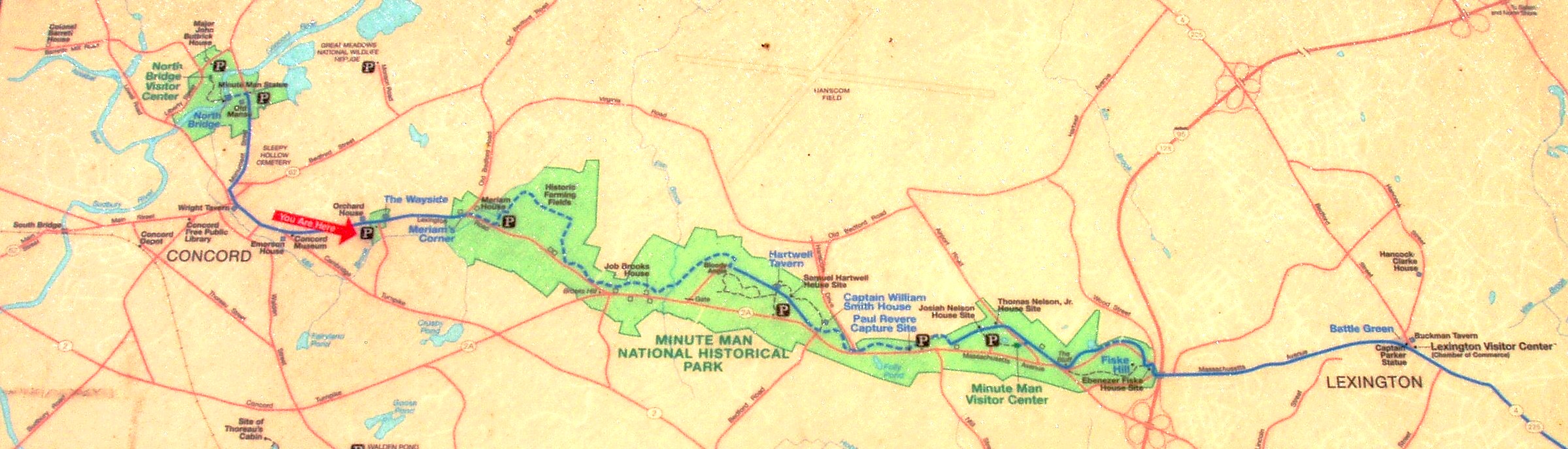
- The five-mile (8 km) "Battle Road Trail" between Lexington and Concord, which includes a restored colonial landscape approximating the path of the running skirmishes between British troops and Colonial militia, a monument at the site where Paul Revere was captured during his midnight ride, and the Hartwell Tavern, a restored 18th-century inn and house on the Battle Road, where living history programs are presented from May through October. The Battle Road Trail winds through fields and forests and is accessible from several different parking areas.
- The Wayside, home in turn to authors Louisa May Alcott, Nathaniel Hawthorne, and Margaret Sidney.
Park visitor centers are located at the hill overlooking the North Bridge and along Battle Road. The main visitor center, on Route 2A/Battle Road, features an exciting 25-minute multi-media show, "Road to Revolution" that gives a good introduction to the Lexington-Concord events.
- Lexington Battle Green, formerly known as Lexington Common, site of the first action on April 19, 1775 is part of the park's story, but the Town of Lexington owns and maintains it. The Green is also where the Captain Parker Statue by H. H. Kitson is located.
Image gallery
-

Old North Bridge, Concord, Massachusetts July 2005
-

The Minute Man statue adjacent to the North Bridge
-

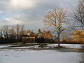
Hartwell Tavern, Lincoln, Massachusetts
-

The Wayside, home in turn to authors Louisa May Alcott, Nathaniel Hawthorne and Margaret Sidney
-
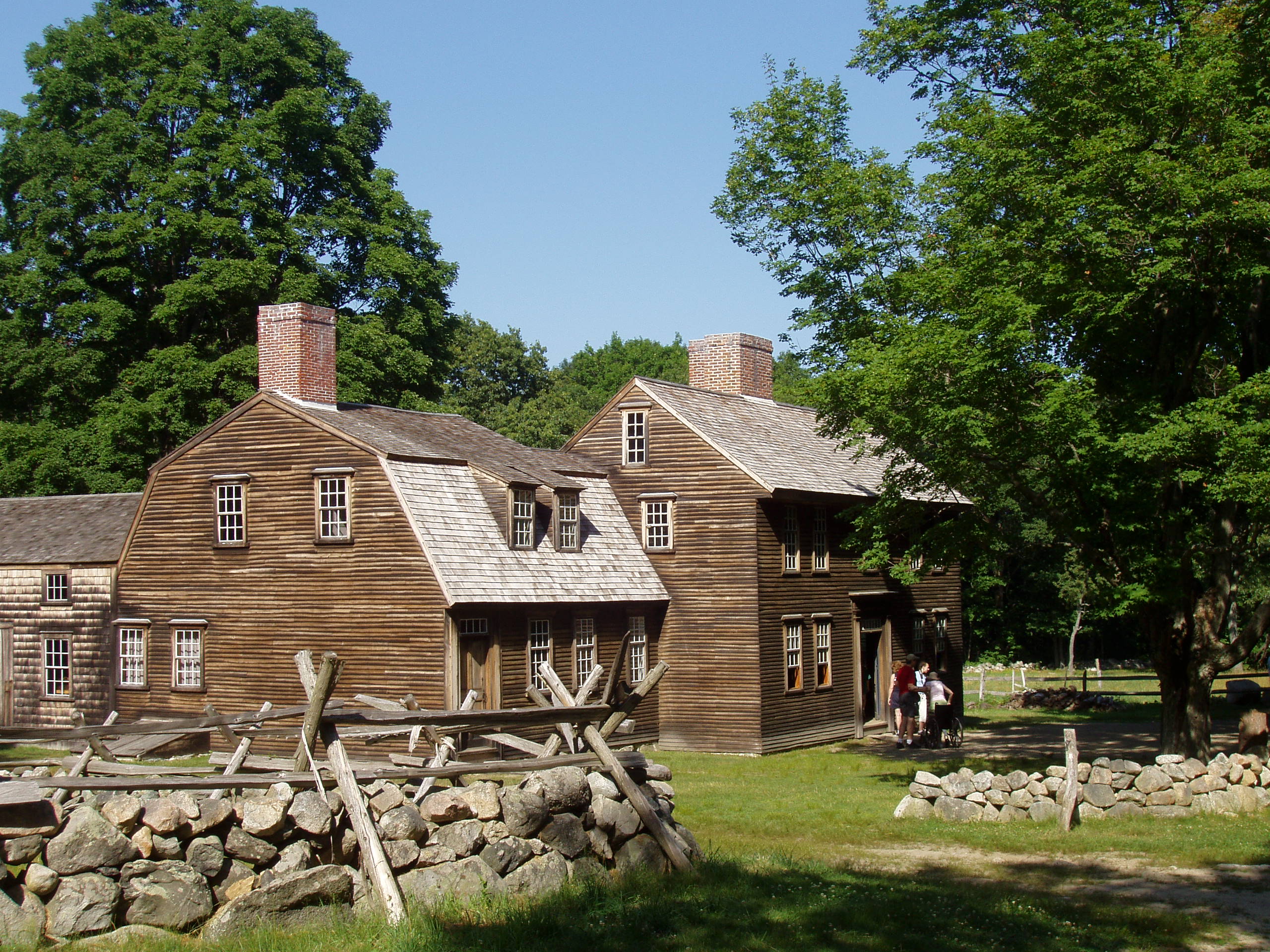
Captain William Smith House
References
- ^ Yeo, Douglas. "Daniel Chester French: The "Concord Minuteman"". http://www.yeodoug.com/resources/dc_french/concord_mman/dcfrench_concord_mman.html. Retrieved 2009-10-31.
External links
- National Park Service: Minute Man National Historical Park
- National Park Service Digital Image Archive of Minute Man NHS
Protected Areas of Massachusetts Federal Adams · Boston · Boston African American · Frederick Law Olmsted · John Fitzgerald Kennedy · Longfellow House · Lowell · Minute Man · New Bedford Whaling · Salem Maritime · Saugus Iron Works · Springfield Armory
Appalachian National Scenic Trail · Boston Harbor Islands National Recreation Area · Cape Cod National Seashore · Stellwagen Bank National Marine Sanctuary · Waquoit Bay National Estuarine Research Reserve · West Hill Dam
Assabet River · Great Meadows · Mashpee · Massasoit · Monomoy · Nantucket · Nomans Land · Oxbow · Parker River · Silvio O. Conte · Thacher Island
State Alewife Brook · Ames Nowell · Ashland · Bash Bish Falls · Blackstone River and Canal Heritage · Borderland · Boston Harbor Islands · Bradley Palmer · C. M. Gardner · Callahan · Castle Island State Park · Chicopee Memorial · City Square · Clarksburg · Cochituate · Connecticut River Greenway · Demarest Lloyd · Dighton Rock · Dunn · Ellisville Harbor · Fall River Heritage · Gardner Heritage · Great Brook Farm · Halibut Point · Hampton Ponds · Holyoke Heritage · Hopkinton · Lake Lorraine · Lake Wyola · Lawrence Heritage · Lowell Heritage · Lynn Heritage · Massasoit · Maudslay · Moore · Mount Holyoke Range · Natural Bridge · Nickerson · Pearl Hill · Pilgrim · Quinsigamond · Robinson · Roxbury Heritage · Rutland · Skinner · South Cape Beach · Wahconah Falls · Webb Memorial · Wells · Western Gateway Heritage · Whitehall · Wompatuck
State Parks:
ReservationsBeaver Brook · Belle Isle Marsh · Blue Hills · Breakheart · Charles River · Chestnut Hill · Cutler · Dorchester Shores · Elm Bank · Fort Phoenix · Hammond Pond · Hemlock Gorge · Horseneck Beach · Jug End · Lynn Shore · Middlesex Fells · Mount Everett · Mount Greylock · Mount Sugarloaf · Mount Tom · Myles Standish · Mystic River · Nahant Beach · Nantasket Beach · Nasketucket Bay · Neponset River · Pope John Paul II · Purgatory Chasm · Quincy Quarries · Quincy Shore · Revere Beach · Rumney Marsh · Salisbury Beach · Sandy Point · Scusset Beach · Stony Brook · Upper Charles River · Wachusett Mountain · Walden Pond · Weymouth · Wilson Mountain
State Parks:
OtherAppalachian Trail · Ashuwillticook Rail Trail · Cape Cod Rail Trail · Fort Revere · Lake Dennison Recreation Area · Lower Neponset River Trail · Nashua River Rail Trail · Norwottuck Rail Trail · Quabbin Reservoir · Southwest Corridor Park · Squantum Point Park · Streeter Point Recreation Area · Sudbury Reservoir · Wachusett Reservoir · Ware River Watershed Area
Barnstable · Beartown · Brimfield · Chester-Blandford · DAR · Douglas · Erving · F. Gilbert Hills · Federated Women's Club · Freetown-Fall River · Georgetown Rowley · Granville · Harold Parker · Kenneth Dubuque Memorial · Leominster · Lowell-Dracut-Tyngsboro · Manuel F. Correllus · Mohawk Trail · Monroe · Mount Grace · Mount Washington · Myles Standish · October Mountain · Otter River · Pittsfield · Sandisfield · Savoy Mountain · Shawme-Crowell · Spencer · Tolland · Upton · Wendell · Willard Brook · Willowdale · Windsor
Agawam Lake · Agawam Mill Pond · Ashby · Ashfield Hawley · Attitash · Ayer Game Farm · Baddacook Pond · Bakers Pond · Bay Circuit Trail · Bearse Pond · Becket · Bennett · Birch Hill · Black Brook · Blackstone / West River · Bolton Flats · Boxboro Station · Brayton Point Salt Marsh · Breakneck Brook · Brewer Brook · Bullock Ledge · Burrage Pond · Canoe River · Catamount · Chalet · Chase Garden Creek Salt Marsh · Childs River · Chockalog Swamp · Church Homestead · Clapps Pond · Clinton Bluff · Concord River · Connecticut River · Cook Pond · Copicut · Coy Hill · Crane Pond · Cummington · Cusky Pond · Dartmoor Farm · Darwin Scott Memorial · Day Mountain · Deerfield River · Dogfish Bar Beach Coastal · Dolomite Ledges · Dunstable Brook · E. Kent Swift · Eagle Island · East Mountain · Eastham Salt Marsh · Elbow Meadow · English Salt Marsh · Eugene D. Moran · Facing Rock · Fairfield Brook · Farmington River · Fish Brook · Fisherville Pond · Fisk Forestdale Lot · Fisk Meadows · Five Mile River · Flagg Swamp · Flint Pond · Four Chimneys · Fox Den · Fox Island Salt Marsh · Frances A. Crane · Freetown Swamp · George L. Darey Housatonic Valley · Glen Echo Lake · Gosnold · Grassy Pond (Dennis) · Grassy Pond (Plymouth) · Green River (Franklin County) · Green River (Berkshire County) · Greenfield River · Halfway Pond · Hamilton · Hancock · Harlow / Cooks Pond · Haskell Swamp · Hauk Swamp · Hawksnest State Park · Hawley · Head Of The Plains · Herman Covey · High Ridge · Hinsdale Flats · Hiram H. Fox · Hockomock Swamp · Hog Pond Lot · Honey Pot · Hoosatonic River · Hoosic River · Hop Brook · Housatonic River · Hubbard Brook · Hunting Hills · Hyannis Ponds · Ipswich River · John J. Kelly · Jug End Fen · Jug End · Kampoosa Fen · Katama Plains · Knops Pond · Konkapot River · Lackey Pond · Lake Lorraine · Lake Rohunta · Lake Snipatuit · Lake Warner · Lanesboro · Lawrence Brook · Lawrence Pond Lot · Leadmine · Leyden · Lilly Pond · Little Alum Pond · Long Sought For Pond · Maple Hill · Maple Springs · Martha Deering · Martin H. Burns · Mascuppic Lake · Mashpee Pine Barrens · Mashpee Pond Lot · Mashpee River · Massachusetts Military Reservation · Mckinstry Brook · Meetinghouse Swamp · Merrill Pond · Miacomet Heath · Mill River · Millers River · Mine Brook · Montague Plains · Montague · Moose Brook · Moose Brook · Moose Hill · Mossy Pond · Mount Watatic Reservation · Mt. Esther · Mt. Toby Highlands · Mt. Toby · Mt. Tom · Muddy Brook · Muddy Pond · Mulpus Brook · Nashua River · Natty Brook · Nemasket River · Nissitissit River · Noquochoke · Nordeen Marsh · North Brookfield · North Shore Salt Marsh · Northboro · Oakham · Olivers Pond · Orange · Otis · Packard Pond · Palmer · Pantry Brook · Pauchaug Brook · Peru · Peterson Swamp · Phillipston · Podunk Marsh · Poland Brook · Popple Camp · Popponesset Beach · Poutwater Pond · Powell Brook · Prince River · Provincetown Route 6 Corridor · Purchade Brook · Quaboag · Quacumquasit · Quag Pond Bog · Quashnet River · Quashnet Woods State Reservation · Quinapoxet River · Quinsigamond Marsh · Quisset · Raccoon Hill · Rainbow Beach · Red Brook · Richardson · Robbins Pond · Rochester · Rocky Gutter · Rowe · Salisbury Salt Marsh · Salisbury Salt Marsh · Sandwich Game Farm · Sandy Pond · Satan's Kingdom · Savage Hill · Savoy · Sawmill River · Scorton Creek Coastal · SE Mass Bioreserve · Sevenmile River · Shattuck Brook · Sheperds Island · Shubael Pond · Sibley Brook · Sly Pond · South Barrier Beach · South Meadow Pond · South Shore Salt Marsh · South Triangle Pond · Southampton · Southwick · Spectacle Pond · Springhill Lot · Sputtermill Pond · Squannacook River · Stafford Hill · Sudbury River · Sunderland Islands · Taconic Mountain · Taunton River · Taunton River · Tekoa Mountain · Thad Ellis · Thayer Pond · Three Mile Pond · Townsend · Townsend Hill · Trapfall Brook · Triangle Pond · Tully Brook · Tully Mountain · Tully River · Wakeby Pond · Wales · Walnut Hill · Ware River · Warwick · Wendell · West Meadows · Westboro · Westfield River · Westfield · Weymouth Back River · Whately Great Swamp · Whately Ponds · Whately · Wilbraham Game Farm · William Forward · Williams River · Williamsburg · Winimusset · Wolf Swamp ·Billingsgate Island · Carr Island · E. Howe Forbush · Egg Rock · Grace A. Robson · J.C. Phillips · Knight · Penikese Island · Ram Island (Salisbury) · Ram Island (Mattapoisett) · Susan B. Minns · Tarpaulin Cove · Watatic Mountain ·Private Roger and Virginia Drury Preserve · Tatkon Preserve · McElwain-Olsen Preserve · Reed Brook Preserve · Hawley Bog Preserve · Stacy Mountain Preserve · Greene Swamp Preserve · Black Pond Bog Nature Preserve · Halfway Pond Island Preserve · Grassy Pond Preserve · Boat Meadow Preserve · Sandy Neck Preserve · Hockomock Swamp · David H. Smith Preserve and Fire Trail · Hoft Farm Preserve · Katama Plains Preserve · Francis Newhall Woods Nature and Wildlife Preserve · Miacomet Moors Preserve · Homer-Watcha Preserve ·
Agassiz Rock · Appleton Farms · Appleton Farms Grass Rides · Ashintully Gardens · Bartholomew's Cobble · Bear's Den · Bear Swamp · Colonel John Ashley House · Francis William Bird Park · Eleanor Cabot Bradley Estate · Bridge Island Meadows · Brooks Woodland Preserve · William Cullen Bryant Homestead · Cape Poge Wildlife Refuge · Cedariver · Castle Hill · Chapel Brook · Charles River Peninsula · Chase Woodlands · Chesterfield Gorge · Coolidge Reservation · Copicut Woods · Cormier Woods · Coskata-Coatue Wildlife Refuge · Crane Beach · Crane Wildlife Refuge · Crowninshield Island · Dexter Drumlin · Dinosaur Footprints · Doane's Falls · Doyle Reservation · Dry Hill · East Over Reservation · Elliott Laurel · Field Farm · Fork Factory Brook · Glendale Falls · Goose Pond Reservation · Greenwood Farm · Halibut Point Reservation · Hamlin Reservation · Holmes Reservation · Governor Hutchinson's Field · Jacobs Hill · Little Tom Mountain · Long Hill · Long Point Wildlife Refuge · Lowell Holly Reservation · Lyman Reserve · Malcolm Preserve · Mashpee River Reservation · McLennan Reservation · Medfield Meadow Lots · Medfield Rhododendrons · Menemsha Hills · Misery Islands · Mission House · Monument Mountain · Moose Hill Farm · Mount Ann Park · Mountain Meadow Preserve · Mytoi · Naumkeag · Noanet Woodlands · Noon Hill · Norris Reservation · North Common Meadow · Norton Point Beach · Notchview · Old Manse · Old Town Hill · Peaked Mountain · Pegan Hill · Peters Reservation · Petticoat Hill · Pierce Reservation · Pine and Hemlock Knoll · Powisset Farm · Questing · Quinebaug Woods · Ravenswood Park · Redemption Rock · Rock House Reservation · Rocky Narrows · Rocky Woods · Royalston Falls · Shattuck Reservation · Signal Hill · Slocum's River Reserve · Stavros Reservation · The Stevens-Coolidge Place · Swift River Reservation · Tantiusques · Tully Lake Campground · Two Mile Farm · Tyringham Cobble · Ward Reservation · Wasque · Weir Hill · Weir River Farm · Westport Town Farm · Whitney and Thayer Woods · World's End ·
Arcadia · Broad Meadow Brook · Broadmoor · Drumlin Farm · High Ledges · Ipswich River · North River · Pleasant Valley · Stony Brook · Wachussett Meadow · Wellfleet Bay
OtherConcord Land Conservation Trust · Harvard Forest · Lincoln Land Conservation Trust ·
National Historical Parks of the United States Abraham Lincoln Birthplace • Adams • Appomattox Court House • Boston • Cane River Creole • Cedar Creek and Belle Grove • Chaco Culture • Chesapeake and Ohio Canal • Colonial • Cumberland Gap • Dayton Aviation Heritage • George Rogers Clark • Harpers Ferry • Hopewell Culture • Independence • Jean Lafitte • Kalaupapa • Kaloko-Honokōhau • Keweenaw • Klondike Gold Rush • Lewis and Clark • Lowell • Lyndon B. Johnson • Marsh-Billings-Rockefeller • Minute Man • Morristown • Natchez • New Bedford Whaling • New Orleans Jazz • Nez Perce • Palo Alto Battlefield • Paterson Great Falls • Pecos • Puʻuhonua o Hōnaunau • Roosevelt Campobello International Park • Rosie the Riveter/World War II Home Front • Salt River Bay • San Antonio Missions • San Francisco Maritime • San Juan Island • Saratoga • Sitka • Thomas Edison • Tumacácori • Valley Forge • War in the Pacific • Women's Rights Full Alphabetical List
U.S. National Register of Historic Places Topics Lists by states Alabama • Alaska • Arizona • Arkansas • California • Colorado • Connecticut • Delaware • Florida • Georgia • Hawaii • Idaho • Illinois • Indiana • Iowa • Kansas • Kentucky • Louisiana • Maine • Maryland • Massachusetts • Michigan • Minnesota • Mississippi • Missouri • Montana • Nebraska • Nevada • New Hampshire • New Jersey • New Mexico • New York • North Carolina • North Dakota • Ohio • Oklahoma • Oregon • Pennsylvania • Rhode Island • South Carolina • South Dakota • Tennessee • Texas • Utah • Vermont • Virginia • Washington • West Virginia • Wisconsin • WyomingLists by territories Lists by associated states Other Categories:- American Revolutionary War sites
- Concord, Massachusetts
- Lexington, Massachusetts
- Landmarks in Massachusetts
- Massachusetts in the American Revolution
- National Register of Historic Places in Massachusetts
- Military in Massachusetts
- Protected areas established in 1959
- National Historical Parks in Massachusetts
- Museums in Middlesex County, Massachusetts
- Military and war museums in Massachusetts
- History museums in Massachusetts
- Parks in Middlesex County, Massachusetts
- American Revolutionary War museums in Massachusetts


Wikimedia Foundation. 2010.