- Mehi River
-
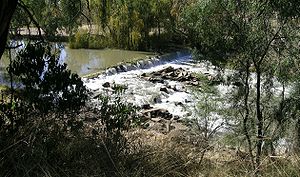 Mehi River Weir at Moree
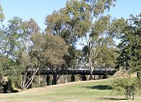 Mehi River Bridge at Moree
The Mehi River is an inland stream in north-western New South Wales which diverts from the Gwydir River, about 21 km east of Moree. From here the river flows generally west, through the town of Moree and then generally west-south-west and westwards to join the Barwon River about 11 km northeast of Collarenebri.
Contents
History
This river which travels about 160 km commencing at its branching off at the Tareelaroi Weir was previously known as the Gwydir River or Meei River.
In 1889 a timber bridge was erected over the Mehi River at Moree. Another bridge was built over Mehi River, Moree in April 1960. The Geographical Names Board of New South Wales officially named Mehi as the 160 km tributary of the Gwydir River in 1975 ending years of confusion over the naming of this section. [1] During December 1995 a bridge over was made over the Mehi River, west of Moree.
Moree has been flooded regularly over the years by the Mehi River. The area adjoining the river has numerous attractive riverside parks, golf links and reserves. The Mehi River jetty at Moree is a popular spot for water sports. The Gwydir Highway, too is subject to flooding of the Gwydir and Mehi Rivers (the highway is actually on an island in the middle of these two rivers near Collarenebri).
During 2008 plans were drawn up to install a fish passage at Moree which will open up a 300 kilometre “freeway” for native fish between Copeton Dam and Collarenebri. The Barwon River-Gwydir CMA has provided $175,000 to Moree Plains Shire Council to install a fish passage at the Moree Town Weir.
Native fish that are found in the Gwydir-Mehi river system include bony bream, Murray cod, spangled perch, golden perch, which are often known as yellowbelly and eel-tailed catfish.
Citations
- ^ Readers Digest Guide to Australian Places, Readers Digest, Sydney
References
- Newell Highway Promotions Committee, The Newell, VINK Publishing, Woolloongabba, QLD, 2005
See also
Coordinates: 29°34′00″S 149°30′00″E / 29.5666667°S 149.5°E
Categories:


Wikimedia Foundation. 2010.