- North Charleston, South Carolina
-
North Charleston — City — City of North Charleston The new City Hall for the City of North Charleston.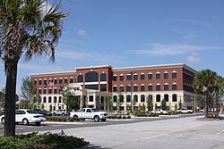
SealNickname(s): "A great place to live, work, and play" Motto: "Perseverance - Progress - Prosperity" 
Coordinates: 32°53′7″N 80°1′1″W / 32.88528°N 80.01694°WCoordinates: 32°53′7″N 80°1′1″W / 32.88528°N 80.01694°W Country United States State South Carolina Counties Berkeley, Charleston, Dorchester[1] Government - Type Mayor-council government - Mayor R. Keith Summey Area - Total 76.6 sq mi (198.393 km2) Elevation 25 ft (6 m) Population (2010) - Total 97,471 - Density 1,360.5/sq mi (525.3/km2) Time zone EST (UTC-5) - Summer (DST) EDT (UTC-4) Area code(s) 843 FIPS code 45-50875[2] GNIS feature ID 1225072 Website www.northcharleston.org North Charleston is the 3rd largest city in the U.S. state of South Carolina with incorporated areas in Berkeley, Charleston, and Dorchester counties.[1] On June 12, 1972 the city of North Charleston incorporated and was the 9th largest city in South Carolina. According to the 2010 Census, North Charleston has a population of 97,471 with a current area of more than 76.6 square miles (198 km2).[3] As defined by the U.S. Office of Management and Budget, and used by the U.S. Census Bureau for statistical purposes only, North Charleston is included within the Charleston – North Charleston – Summerville metropolitan area and the Charleston-North Charleston urban area. The city is considered one of the state's major industrial cities and it is the state's major retail center.[4]
History
The plantations (1680–1901)
From the 17th century until the Civil War, this area was occupied primarily by plantations. Some of the plantations located in what is now North Charleston were:
- Archdale Hall Plantation - dating from 1680, Archdale Hall was located on the Ashley River. By 1783, it had grown to almost 3,000 acres (12 km2). Its primary crops were indigo and rice. The plantation was the longest family owned plantation in South Carolina. It has since been redeveloped into the Archdale subdivision. (note: Archdale subdivision is not in corporate city limits of, but is surrounded by North Charleston)
- Camp Plantation - dating from 1705, Camp Plantation covered around 1,000 acres (4.0 km2).
- Elms Plantation - dating from 1682, Elms Plantation was founded by Ralph Izard. Its principal crop was rice. It covered nearly 4,350 acres (17.6 km2), stretching across parts of what are now the cities of Goose Creek and North Charleston. Charleston Southern University is located on part of the original plantation lands.
 French Botanical Garden historical marker, located off of Aviation Avenue
- French Botanical Garden - established between 1786 and 1796, this small plantation/garden area of 111 acres (0.45 km2) was owned and maintained by the French botanist André Michaux. It was closed by Michaux's son in 1803. The garden was located near what is today the Charleston International Airport, and the parkway connecting Dorchester Road with International Boulevard is named in his honor.
- Marshlands, Mons Repos and Retreat Plantations - the Retreat Plantation dates from 1672 and the Marshlands Plantation dates from 1682. Mons Repos came into being around 1798. All three plantations were combined in later years to form the Charleston Naval Base and Charleston Naval Shipyard. The Marshlands Plantations' main house has been placed on the National Register of Historic Places and moved to Fort Sumter Drive on James Island.
- Oak Grove Plantation - dating from 1680, Oak Grove originally covered 960 acres (3.9 km2) along the Cooper River. By 1750, it had grown to about 1,127 acres (4.56 km2).
- Tranquil Hill Plantation - started in 1683, Tranquil Hill was originally known as White Hall Plantation, a name it would keep until 1773. Its principal crop was rice. It encompassed about 526 acres (2.13 km2). It has since been redeveloped into the Whitehall subdivision.[5]
- Windsor Hill Plantation - established in 1701, Windsor Hill was an inland rice plantation that covered nearly 1,348 acres (5.46 km2), stretching across parts of what are now the cities of Goose Creek and North Charleston.[6] General William Moultrie, victor at the Battle of Sullivan's Island in 1776 and governor from 1785–87 and 1792–94, was originally buried here but was exhumed and reburied at Fort Moultrie on Sullivan's Island in 1977.[7] The Windsor Hill Plantation subdivision occupies a portion of the eponymous plantation's property.
The large plantations were continually subdivided into smaller farms as the population began moving northward. After the Civil War, phosphate fertilizer plants began to spring up, with extensive strip mining occurring between the Ashley River and Broad Path (Meeting Street Road). The main route for transportation of these phosphates would eventually become known as Ashley Phosphate Road.
Birth of a city (1901–1972)
Since the early 20th century, the section of unincorporated Charleston County that later became the city of North Charleston had been designated by Charleston business and community leaders as a place for development of industry, military and other business sites. The first industry started in this area was the E.P. Burton Lumber Company. In 1901, the Charleston Naval Shipyard was established with agreements between the Federal Government and local Charleston city leaders. Shortly thereafter, the General Asbestos and Rubber Company built the world's largest asbestos mill under one roof.
In 1912, a group of businessmen from the city of Charleston formed a development company that bought the E.P. Burton Lumber Company tract and began to lay out an area for further development. The Park Circle area was one of the first to be designed and developed, allocating sections for industrial, commercial, and residential usage. Park Circle was planned as one of only two English Garden Style communities in the US and most of the original planning concept remains today. Some of the streets in the area still bear the names of these original developers: Durant, Buist, Mixon, Hyde, and O'Hear. During World War II, substantial development occurred as the military bases and industries expanded and people moved to the region to be closer to where they worked.
From World War II through the 1960s, many people who lived in this region (referred to by Charlestonians as the North Area) were unhappy about the way parts of their community were being developed. They wanted the citizens in the area to have direct control over future development. Many of their attempts to create an independent city were defeated via court rulings. As a means of bringing government closer to the people, an incorporation referendum was held on April 27, 1971. On June 12, 1972, after a series of legal battles, the South Carolina Supreme Court upheld the referendum results and North Charleston became a city with John E. Bourne Jr. as its first mayor.
The first 10 years (1972–1982)
When North Charleston incorporated on June 12, 1972, it consisted of several areas including the Russelldale, Ferndale, Morningside, Liberty Park, Palmetto Heights, Singing Pines, Dewey Hill, Liberty Homes and John C. Calhoun Homes neighborhoods. Within the first week of operation, the city passed a 61-page Code and signed a five year lease for 308 Montague Avenue for $300.00 per month. Also, during the month of June, the city hired a police chief, treasurer and annexed its first industry, which was Textone Incorporated Plywood, Westvaco. On June 21, a ribbon was cut on the first city park on Virginia Avenue. At the end of the first month, the city reached an agreement for garbage collection and fire protection by the local public service district. The month concluded with the city’s first big annexation, south of Bexley Street between Spruill Avenue and the Charleston Naval Shipyard. By December, North Charleston had become the 4th largest city in the state after annexing the Naval Base, the Air Force Base and the Charleston International Airport.[4]
In February 1973, North Charleston had doubled its area through annexation, and in March expanded into Berkeley County. In May 1973, the city launched its new police department, which included 21 officers and six cars. By the end of North Charleston’s first year, the population had increased from 22,000 to 53,000.
Through continued growth that included 20 churches, a 62 store shopping mall and other large tracts of residential neighborhoods, the city became the 3rd largest city in South Carolina on July 3, 1976.
On June 12, 1982, North Charleston had a population of 65,000 in a 30.5-mile (49.1 km) area. In ten short years the city's growth rate was 250 percent. It had made $15 million in capital investments; $1.95 million invested in parks and recreation facilities, and $2.28 million in economic development.
Growing pains (1982–1996)
In 1983, North Charleston became the first city in South Carolina to implement a computer aided dispatch system. Baker Hospital opened a new facility on the banks of the Ashley River. The following year, Wal-Mart announced plans to open one of the nation’s first Sam’s Clubs in North Charleston. Plans were revealed in 1985 for the 400-acre (1.6 km2) Centre Pointe development which included Sams Club, Wal-mart and Tanger Outlet Mall as anchors.
By 1986, North Charleston's population had reached 78,000 residents spanning 47 square miles (120 km2). A monument to honor Vietnam veterans was erected and dedicated in front of City Hall, where it stood for over 20 years before being moved to Patriots Point in 2008. The city celebrated its 15th anniversary the next year, marked by such events as the opening of the Northwoods Center shooping complex and the appearance of a beach in the middle of the city with the opening of Treasure Lake.
In September 1989, Hurricane Hugo brought devastation to the area, causing over $2.8 billion in damage to the South Carolina Lowcountry.
In 1991, John E. Bourne, Jr. lost his bid for a sixth term as mayor to Bobby Kinard, who became the city's second mayor. Kinard's tenure as mayor was tumultuous and was marked by repeated conflict with the City Council, who went so far as to strip Kinard of his mayoral powers during a council meeting. Kinard would resign in 1994 on the grounds that his relationship with the council was damaged irreparably.[8]
The area saw welcome expansion in 1993 when a squadron of the C-17 Globemaster III aircraft was established at Charleston Air Force base. The North Charleston Coliseum opened and the South Carolina Stingrays of the ECHL began play later that year.
Following Bobby Kinard's resignation in 1994, R. Keith Summey was elected the city’s third mayor to fill the vacant seat.
An era ends; a city is reborn (1996–present)
The Charleston Naval Base remained the largest employer of civilians in South Carolina into the 1990s. The influence of Lowcountry legislators and the threat of nuclear attack played an important role in keeping North Charleston's bases open in the face of periodic attempts at closure.
However, in the early 1990s, with the resolution of the Cold War and impending defense budget cuts, the Charleston Navy Base was once again on the chopping block. In 1993, the Charleston Naval Base was given a closure date of April 1, 1996. With an annual expenditure of approximately 1.4 Billion dollars the closing of the base was a blow to the entire Tri-County economy. Over the years, billions of dollars had flowed into the region's economy and hundreds of thousands of jobs were provided to military and civilian personnel,[9] the vast majority being civilians. Many military personnel who worked at or passed through the base returned to the city to retire. Following the closure of the Charleston Naval Base and the Charleston Naval Shipyard, parts of the base and dry-docks were leased out to various government and private businesses. Community parks for North Charleston were established on old base grounds, to include Riverfront Park.
After years of development, community input and revisions, the Noisette Community Master Plan for the old naval base was finalized in a contractual agreement in early 2004. The plan sought to preserve historic architectural styles, neighborhood diversity and the area’s unique social fabric. It also intended to restore environmental stability and beauty, attract jobs, improve services like education and health care, reduce dependence on car travel, promote recreation, eliminate the foundations of crime and poverty, and strengthen residents' sense of pride.
In the following years, however, the plan failed to come to fruition. In 2005, city officials discovered that Noisette had borrowed $3 million against land on the former base without their knowledge. The next year, Noisette borrowed $23.7 million from Capmark Investing Group, using the majority of its remaining land on the base as collateral. Noisette failed to make timely repayment to Capmark, and the property went into foreclosure. Representatives of Noisette insisted at the time that they would be able to repay Capmark and make good on their vision for redeveloping the old Navy base.[10]
Discussion between city and state officials regarding the industrial development of remaining portions of the former base stalled in 2009 primarily due to a dispute over rail access to a proposed intermodal terminal that would occupy the central portion of the area. Representatives of the state government sought to have rail access from both the north and south. This notion was directly contradicted by Mayor Summey, who insisted that the northern rail access be abandoned to avoid heavy rail traffic through the slowly revitalizing Park Circle neighborhood.[10]
In October 2009, Boeing Aircraft announced the selection of North Charleston for its new 787 Dreamliner aircraft assembly and delivery prep center. This positioned North Charleston as one of the major aircraft centers of the world and paved the way for thousands of new jobs to provide quality work for residents of the city and the entire Tri-County area.[11]
In a tragic series of events in June 2010, former mayor Bobby Kinard committed suicide after dealing with depression in the aftermath of his experiences in the Vietnam War.[8] In December of that year, a Delaware corporation with ties to former state Commerce Secretary Bob Faith bought the largest parcel (approximately 240 acres (0.97 km2) at the north end of the former base) of Noisette land.[12] The corporation then transferred the deed for that land to the state's Commerce Department's Public Railways Division, giving them the impetus to move forward with their proposed rail yard with northern and southern access despite Mayor Summey's objections. The North Charleston mayor announced his intent to file a lawsuit against the state Commerce Department on the grounds that their plan violated the city's agreement with the State Ports Authority that no rail be run through the north end of the former base.[13]
North Charleston today
With the arrival of Boeing Aircraft, the city has gained international importance and stature as one of only four places in the world for the manufacture and assembly of wide-body commercial aircraft. The other three places are in and around Everett, Washington (Boeing), Toulouse, France (Airbus) and Voronezh, Russia (Ilyushin).
North Charleston continues to be the State’s leader in retail sales for the sixteenth consecutive year. In calendar year 2007, gross retail sales exceeded $6.15 billion and surpassed its nearest competition, Columbia, South Carolina, by over $2 billion.
The city continues to expand its inventory of 4-star hotel accommodations. By the end of 2009, North Charleston had 7,246 rooms available for visitors to this region of South Carolina.
North Charleston is the home to the Global Financial Services - Charleston (US State Dept), located at the old Naval Station. Global Financial Services - Charleston is responsible overall for more than 200 bank accounts in over 160 countries and 169 different currencies. In 2005, it disbursed over $10 billion and purchased over $3 billion in foreign currency.
As part of an initiative by the Department of Veterans Affairs to provide mail order prescriptions to veterans using computerization, at strategic locations, North Charleston is home to a Consolidated Mail Outpatient Pharmacy (CMOP).
Since the construction of Palmetto Commerce Parkway, many businesses (including Venture Aerobearings, Daimler Vans Manufacturing, Cummins Turbo, and the VTL Group) have located and invested hundreds of millions of dollars in North Charleston’s local economy. Industrial hubs, such as this one, continue to provide high paying jobs in the area’s economy.
Geography
North Charleston is located near the Atlantic Ocean in the Coastal zone just north of Charleston in South Carolina. According to the 2010 United States Census, the city has a total area of 76.6 square miles (160.8 km2).
Climate
Climate data for North Charleston, South Carolina (Airport) 32.8951 North and -80.0275 West Month Jan Feb Mar Apr May Jun Jul Aug Sep Oct Nov Dec Year Average high °F (°C) 57.1
(13.9)59.8
(15.4)65.8
(18.8)72.9
(22.7)79.6
(26.4)84.9
(29.4)88.5
(31.4)87.1
(30.6)83.0
(28.3)75.1
(23.9)67.6
(19.8)60.0
(15.6)73.5 Average low °F (°C) 42.4
(5.8)44.9
(7.2)51.5
(10.8)58.5
(14.7)67.4
(19.7)73.8
(23.2)77.0
(25.0)76.1
(24.5)72.2
(22.3)61.9
(16.6)53.4
(11.9)45.5
(7.5)60.4 Precipitation inches (mm) 3.62
(91.9)2.62
(66.5)3.83
(97.3)2.44
(62)2.77
(70.4)4.96
(126)5.50
(139.7)6.54
(166.1)6.13
(155.7)3.02
(76.7)2.18
(55.4)2.78
(70.6)46.39
(1,178.3)Avg. precipitation days (≥ 0.01 in) 10.1 8.0 8.5 7.0 7.6 10.6 11.4 11.9 9.7 6.1 7.0 9.0 106.9 Sunshine hours 179.8 189.3 244.9 276.0 294.5 279.0 288.3 257.3 219.0 223.2 189.0 170.5 2,810.8 Source: NOAA,[14] HKO[15] Demographics
Historical populations Census Pop. %± 1980 62,479 — 1990 70,218 12.4% 2000 79,641 13.4% 2010 97,471 22.4% U.S. Decennial Census As of the census[2] of 2000, there were 79,641 people, 29,783 households, and 18,971 families residing in the city. The population density was 1,360.6 people per square mile (525.3/km2). There were 33,631 housing units at an average density of 574.5 per square mile (221.8/km2). The racial makeup of the city was 49.41% African American, 44.76% White, 0.44% Native American, 1.59% Asian, 0.09% Pacific Islander, 1.78% from other races, and 1.93% from two or more races. Hispanic or Latino of any race were 3.97% of the population.
There were 29,783 households out of which 34.4% had children under the age of 18 living with them, 36.0% were married couples living together, 22.8% had a female householder with no husband present, and 36.3% were non-families. 28.6% of all households were made up of individuals and 6.6% had someone living alone who was 65 years of age or older. The average household size was 2.51 and the average family size was 3.10.
In the city, the population was spread out with 27.9% under the age of 18, 13.4% from 18 to 24, 32.0% from 25 to 44, 17.7% from 45 to 64, and 9.0% who were 65 years of age or older. The median age was 30 years. For every 100 females there were 98.1 males. For every 100 females age 18 and over, there were 95.5 males.
The median income for a household in the city was $29,307, and the median income for a family was $32,868. Males had a median income of $26,681 versus $20,718 for females. The per capita income for the city was $14,361. About 19.9% of families and 23.2% of the population were below the poverty line, including 33.8% of those under age 18 and 13.0% of those age 65 or over.
Government
The city is run by an elected Mayor-council government system with the mayor acting as the chief administrator and the executive officer of the municipality. The mayor also presides over city council meetings and has a vote, the same as other council members. City government moved into a new, more centrally located city hall in 2009, centralizing offices that had been in numerous locations across the city.
Mayor
- Current Mayor
- R. Keith Summey
- Previous Mayors
- John E. Bourne Jr.
- Robert Kinard
- Kenneth McClure (Interim Mayor)
Council members
- District 1 - Ed Astle
- District 2 - Rhonda Jerome
- District 3 - Bobby Jameson
- District 4 - Phoebe Miller
- District 5 - Steve Ayer
- District 6 - Dorothy Williams
- District 7 - Sam Hart
- District 8 - Robert King
- District 9 - Kurt Taylor
- District 10 - Michael Brown
Emergency services
Police department
The North Charleston Police Department was formed in 1973 with 21 officers and five support personnel. Today, the department employs over 300 sworn officers and 100 civilian employees.
Fire department
The first fire department founded in the area to become North Charleston was the St. Phillip's and St. Michael's Fire Department in 1935. They had one station and one engine. The North Charleston Fire Department was formed in 1937 with only one station and one engine. In 1959, the departments merged to become the North Charleston Consolidated Fire Department. NCFD became a paid service in 1962. At which time all the volunteers were released and they formed the organization today known as the Charleston County Volunteer Rescue Squad.
The two departments were again merged in 1996 to become the North Charleston Fire Department. There were 10 fire stations, 10 engines, 3 ladder trucks and 2 squads at that time. In the past 13 years, the department has grown to include new technology and new training. They have thermal imagers in each station, a confined-space rescue team, a hazardous materials team, a marine firefighting team, and each firefighter in the department is trained to a minimum of IFSAC Firefighter One.
EMS
The Emergency Medical Services for the City of North Charleston are provided by Charleston County Emergency Medical Services and Dorchester County Emergency Medical Services. The city is served by both Charleston and Dorchester counties EMS and 911 services since the city is part of both counties.
Crime
The following table shows North Charleston’s crime rate for CY2009 in six crimes that Morgan Quitno uses for their calculation for "America's most dangerous cities" ranking, in comparison to the national average. The statistics provided are for a crime rate based on the number of crimes committed per 100,000 people.[16]
Crime North Charleston (2009) National Average Murder 10.4 5.0 Rape 57.3 28.7 Robbery 391.7 133.0 Assault 575.1 262.8 Burglary 1066.9 716.3 Automobile Theft 631.4 258.8 Since 1999, the overall crime rate of North Charleston has begun to decline. The total violent crime index rate for North Charleston for 1999 was 1043.5 crimes committed per 100,000 people, with the United States average at 729.6 per 100,000. North Charleston had a total violent crime index rate of 612.4 per 100,000 for the year of 2009, versus a national average of 429.4 per 100,000.[16]
According to the Congressional Quarterly Press 2009 City Crime Rankings: Crime in Metropolitan America, North Charleston ranked as the 22nd most dangerous American city larger than 75,000 inhabitants.[17][18] However, the entire Charleston-North Charleston-Summerville Metropolitan Statistical Area had a lower overall crime rate ranking at #35.[19]
The 2010 Congressional Quarterly Press list of America's 400 most dangerous cities placed North Charleston at #63, a significant drop from the previous year. The homicide rate alone decreased by 61%, and the lower crime rate removed North Charleston from the company of such cities as Detroit and St. Louis, placing it more in line with average, medium-sized Southern cities like Columbia and Chattanooga. City officials attributed the drop to the hard work of the North Charleston Police Department and the cooperation of city residents.[20]
Infrastructure and economy
- Boeing - Located adjacent to the Charleston International Airport, Boeing has set up an East Coast facility in North Charleston for manufacturing fuselage components, assembling, and flight testing Boeing 787 aircraft, ready for delivery to airlines.[11]
- Computer Sciences Corporation - Branch offices - IT/business services company.
- Cummins Turbo Technologies - Corporate center and manufacturing plant (truck engine parts). Located on Palmetto Commerce Parkway.[21]
- Daimler Vans Manufacturing LLC - Plant for manufacturing Daimler Vans, employing 200 people. Located on Palmetto Commerce Parkway.[22]
- Hess Gasoline Distribution Center - port facilities for tanker ships, serving the entire Tri-County Metro area Hess gas stations. Located off Virginia Avenue.
- InterContinental Hotels Group - Call center of parent company for Holiday Inn hotels, employing more than 400 people. Located on Ashley Phosphate Road.[23]
- iQor - Call center providing outsourced customer service, retention, and revenue recovery services to large and mid-sized companies. Employs 360 workers. Located on Dorchester Road.[24]
- Kapstone Paper and Packaging - Kraft paper mills employing 1,100 workers. Located on the Cooper River.[25]
- Robert Bosch Corporation - Manufacturer of diesel injector components, located off Dorchester Road. (note: Robert Bosch is not in corporate city limits of, but is surrounded by North Charleston)[26]
- Verizon Wireless - Call center of parent company for Verizon, employing 700 workers. Located on Mall Drive.[24]
- Venture Aerobearings - Plant manufactures bearings for jet engines. Located on Palmetto Commerce Parkway.[27]
U.S.P.S. Zip Codes
The City of North Charleston is served by these Zip Codes:[28]
- 29404
- 29405
- 29406 - This zip code is incorrectly listed by U.S.P.S. as serving the City of Charleston. It only serves the City of North Charleston[29]
- 29418
- 29420
- 29456
- 29485
Transportation
Major highways
 U.S. Route 52 (I-26 exit 209, I-526 exit 18)
 U.S. Route 78 (I-26 exit 205)
 SC 61 - Ashley River Road at Watson Hill
 Interstate 26 (I-526 exit 17)
 I-526 (I-26 exit 212)
 Business Spur 526
 SC 165 - Delemar Highway, at Watson Hill
 SC 7 - Cosgrove Avenue (I-26 exit 216)
 SC 642- Dorchester Road, from U.S. 52 to U.S. 17 (I-26 exit 215)
Other major thoroughfares
- Ashley Phosphate Road - from SC 642 to U.S. 52 (I-26 exit 209)
- Aviation Avenue - from S. Aviation Road (Charleston Air Force Base access) to U.S. 52 (I-26 exit 211)
- International Boulevard - from Charleston International Airport to Montague Avenue (I-526 exit 16)
- Ladson Road - from SC 642 to U.S. 78
- Michaux Parkway - from SC 642 to International Boulevard (to Charleston International Airport)
- Montague Avenue - from SC 642 to Virginia Avenue through Park Circle (I-26 exit 213, I-526 exit 16)
- Rhett Avenue - from Liberty Hall Road (Goose Creek) to U.S. 52 through Park Circle (I-526 exits 19 and 20)
- Remount Road - from S. Aviation Road to Virginia Avenue (I-26 exit 211)
Airlines
Charleston International Airport and the Charleston Air Force Base provide commercial and military air service for the region. The airport currently serves more than 1.1 million passengers annually and 14.9 million pounds of freight with a total of 108,438 flights. Commercial airlines include American Airlines, Continental Airlines, Delta Air Lines, Northwest Airlines, Southwest Airlines, United Express, and US Airways. Airtran previously provided service to the International Airport but ceased on December 3, 2009, citing concerns that the route was no longer "economically viable".[30] Southwest Airlines began local service March 13, 2011.[31]
Motor freight
North Charleston is home to many motor carriers servicing routes throughout the US.
Port facilities
The South Carolina State Ports Authority has four intermodal facilities, one of which is located in North Charleston. A new intermodal facility is being built on the former Charleston Naval Base. Each facility handles container, bulk, and break bulk cargo. With more than 2,000,000 square feet (190,000 m2) of warehouse and storage space, the port terminals can accommodate more than 17 vessels at a time. Veterans Terminal is designed mainly for bulk/break bulk cargo.
Terminals
- North Charleston Terminal
- Veterans Terminal
Railroads
Amtrak, Norfolk Southern, the CSX System and the South Carolina Railroad Commission provide passenger and freight rail service in North Charleston.
Intermodal Transportation Center
The North Charleston Intermodal Transportation Center will consolidate a new train station, long haul and CARTA (local bus service) at one location.
Bus transportation
North Charleston is served by a bus system, operated by the Charleston Area Regional Transportation Authority (CARTA). The majority of the city is served by regional fixed route buses which are also equipped with bike racks as part of the system's Rack & Ride program.
Rural parts of North Charleston and the Tri-County metropolitan area are served by a different bus system, operated by Berkeley-Charleston-Dorchester Rural Transportation Management Association (BCD-RTMA).
Hospitals
 Trident Regional Medical Center, main building, City of North Charleston. 2010
The Trident Regional Medical Center is the major hospital located in North Charleston. There are several hospitals located throughout the area serving city residents. These hospitals are the Medical University of South Carolina, Ralph H. Johnson VA Medical Center, Bon Secours-St Francis Xavier Hospital and Roper Hospital, located in Charleston. The East Cooper Regional Medical Center, located in Mount Pleasant, is another local hospital serving residents.
Culture
Orphanage
In 1937 the Jenkins Orphanage (now Jenkins Institute For Children) left the city of Charleston and moved to 3923 Azalea Drive in what is now the city of North Charleston. The Institute is renowned for its contributions to the welfare of its charges and the Jenkins Orphanage Band.
Museums, historical sites, and other attractions
- The H.L. Hunley Museum is located at the old Naval Base in North Charleston. The Civil War era submarine, recovered from the ocean floor August 8, 2000, is undergoing restoration and examination. There are scores of artifacts that have been recovered from the submarine on display. The Hunley bears the distinction of being the first successful combat submarine in the world.
- The Greater Charleston Naval Memorial is located at Riverfront Park on the old Navy Yard. It features sculptures of the different types of ships built and serviced at the Charleston Naval Shipyard, and also features full-size replicas of the Lone Sailor and Homecoming sculptures.
- The American LaFrance Fire Museum & Educational Center is located between Tanger outlet mall and the North Charleston Coliseum. The museum is filled with one of a kind and antique vehicles and fire equipment (some from as early as the mid 18th century) and utilizes multiple interactive displays.
Charleston Area Convention Center
From its establishment in August 1999, the Convention Center has attracted millions of guests and visitors to North Charleston and contributed significantly to the local and regional economy. The Complex includes exhibition halls, ballrooms and meeting rooms.[32]
Coliseum and Performing Arts Center
- The North Charleston Coliseum is located near the Charleston International Airport. The coliseum is one of the largest venues in South Carolina with 13,295 seats. The coliseum also hosts many special events, concerts, and local graduations. The coliseum is home to the South Carolina Stingrays hockey team of the ECHL.[33]
- The North Charleston Performing Arts Center seats up to 2,341 and hosts major Broadway shows as well as national and world renowned musical and theatrical performers.[34]
The Performing Arts Center, the North Charleston Coliseum, the Charleston Area Convention Center are owned by the city of North Charleston and managed by SMG. Together with the co-located Embassy Suites hotel, they help create an entertainment and cultural complex that serves the city of North Charleston and the entire region.
Sports
The South Carolina Stingrays, an ECHL (minor league professional ice hockey) team, have been affiliated with the Washington Capitals of the National Hockey League since 2004. The Stingrays play their home games at the North Charleston Coliseum.
Nearby cities and towns
- City of Charleston
- City of Folly Beach
- City of Goose Creek
- City of Hanahan
- City of Isle of Palms
- City of Walterboro
- Town of Awendaw
- Town of Cottageville
- Town of Hollywood
- Town of McClellanville
- Town of Meggett
- Town of Mount Pleasant
- Town of Rockville
- Town of Sullivan's Island
- Town of Summerville
Other unincorporated areas
- Dewees Island
- Edisto Island
- James Island
- Johns Island
- Ladson
- Wadmalaw Island
- Yonges Island
Parks
- Danny Jones Complex
- MWV/Kapstone Park
- Northwoods Park
- Park South
- Park Circle
- Quarterman Park
- Ralph M. Hendricks Park
- Riverfront Park
County parks
The Charleston County Park and Recreation Commission (CCPRC) operates numerous facilities within Charleston County.
Beach parks:
- Folly Beach County Park, Folly Beach, South Carolina
- Isle of Palms County Park, Isle of Palms, South Carolina
- Kiawah Beachwalker County Park, Kiawah Island, South Carolina
Fishing piers:
- Folly Beach Fishing Pier, Folly Beach, South Carolina
- Mt. Pleasant Pier, Mt. Pleasant, South Carolina
Marinas and boat landings:
- Cooper River Marina
- Multiple county-wide boat landings
Day parks:
- Caw Caw Nature and History Interpretive Center, Ravenel, South Carolina
- James Island County Park, Charleston, South Carolina
- Mullet Hall Equestrian Center, Johns Island, South Carolina
- Wannamaker County Park, North Charleston, South Carolina
- Palmetto Islands County Park, Mt. Pleasant, South Carolina
Water parks:
- Splash Island at Palmetto Islands County Park
- Splash Zone at James Island County Park
- Whirlin' Waters at Wannamaker County Park
Off-leash dog parks are offered at James Island, Palmetto Islands, and Wannamaker County Parks.
Schools, colleges, and universities
 Outer wall and name plate for Charleston Southern University, City of North Charleston. 2010See also: List of schools in North Charleston, South Carolina
North Charleston is served by the Charleston County School District and Dorchester School District II. North Charleston is home to Charleston Southern University and Trident Technical College, Main Campus. In North Charleston, near the airport, the Lowcountry Graduate Center offers satellite campus access to some of South Carolinas' most prestigious universities. Clemson, University of South Carolina, Medical University of South Carolina, The Citadel and the College of Charleston all working together to provide lowcountry residents with access to graduate degree programs together in one convenient location. Webster University maintains two locations, one at the Charleston AFB and another just off of International Blvd.
Armed forces
Air Force
- Joint Base Charleston Charleston Air Force Base
- 437th Airlift Wing (Joint Base Charleston)
- 315th Airlift Wing (Joint Base Charleston)
- 628th Air Base Wing (Joint Base Charleston)
- 1st Combat Camera Squadron (Joint Base Charleston)
- 373rd Training Squadron Det 5 (Joint Base Charleston)
- 412th Logistics Support Squadron OL-AC (Joint Base Charleston)
- Air Force ROTC Det 772
- Civil Air Patrol - Charleston Composite Squadron
Coast Guard
- USCGC Dallas (WHEC-716), berthed at Pier Papa.
- USCGC Gallatin (WHEC-721), berthed at Pier Papa.
- USCGC OAK (WLB-211), berthed at Pier Papa.
Marine Corps
- C Company 4th Landing Support Battalion (Marine Corps Reserves) - Vector Avenue, 29406 next to Charleston International Airport.
Navy
- Charleston Naval Hospital - This has been replaced by the Naval Health Clinic Charleston at the Naval Weapons Station in Goose Creek, South Carolina.
-

The 437 Airlift Wing.
-

The 315 Airlift Wing.
-

The 1st Combat Camera Squadron.
-

The 412 Flight Test Squadron.
Media
Main article: Media in North Charleston, South CarolinaBroadcast television
These TV stations have studios in and broadcast from North Charleston, South Carolina.
- WJNI-LP (31 Digital, America One, Independent) owned by Jabar Communications
- WAZS-LP (29 Digital, Azteca America Independent) owned by Jabar Communications
- WTAT-TV (24, Fox): owned by Cunningham Broadcasting Company
- WMMP-TV (36, My Network Television) owned by Sinclair Broadcasting Company.
See also
Notes
- ^ a b City Planning Department (2008-07). City of North Charleston boundary map. City of North Charleston. Retrieved 2011-01-21.
- ^ a b "American FactFinder". United States Census Bureau. http://factfinder.census.gov. Retrieved 2008-01-31.
- ^ Behre, Robert; David Slade (March 24, 2011). "2010 Census:Who we are". Post and Courier. http://archives.postandcourier.com/archive/arch11/0311/arc032411679043.shtml. Retrieved June 13, 2011.
- ^ a b Wise, Warren (2008-03-22). N. Charleston assessed by its founding mayor. Post and Courier. Retrieved 2011-01-14.
- ^ Trinkley, Michael and Debi Hacker (February 2008). Tranquil Hill Plantation: the most charming inland place. Chicora Foundation, Inc. Retrieved 2011-01-14.
- ^ South Carolina Historical Society (1918). Mabel Louise Webber. ed. The South Carolina historical and genealogical magazine. 19. South Carolina Historical Society. pp. 29–31. http://books.google.com/books?id=P7R659ccPdkC&pg=RA1-PA29. Retrieved 13 October 2011.
- ^ Marshall, Edward (October 1, 1984). "Hibben House figured in events of Revolutionary War". The News and Courier: pp. 2-B. http://news.google.com/newspapers?id=pYVJAAAAIBAJ&sjid=4AsNAAAAIBAJ&pg=993,68825&dq=moultrie+exhumed&hl=en. Retrieved 2011-10-13.
- ^ a b Smith, Glenn (2010-06-19). Ex-N. Charleston mayor dead. Post and Courier. Retrieved 2011-01-14.
- ^ Joyce, Terry (1996-03-16). Charleston, Navy part company. Post and Courier. Retrieved 2011-01-16.
- ^ a b Bartelme, Tony and Doug Perdue (2009-11-22). Noisette: The future of the old Charleston Navy Base and a look at the deal that never happened. Post and Courier. Retrieved 2011-01-15.
- ^ a b McDermott, John P. and Yvonne Wenger (2009-10-29). BOEING LANDS HERE. Post and Courier. Retrieved 2011-01-15.
- ^ Stech, Katy (2010-12-08). Noisette parcel gets new owner. Post and Courier. Retrieved 2011-01-15.
- ^ Bird, Allyson and Schuyler Kropf (2010-12-23). Summey promises fight over rail plan. Post and Courier. Retrieved 2011-01-15.
- ^ "Climatography of the United States No. 20 (1971–2000)" (PDF). National Oceanic and Atmospheric Administration. 2004. http://cdo.ncdc.noaa.gov/climatenormals/clim20/va/448906.pdf. Retrieved 2010-06-09.
- ^ "Climatological Normals of Charleston, South Carolina". Hong Kong Observatory. http://www.hko.gov.hk/wxinfo/climat/world/eng/n_america/us/charleston_sc_e.htm. Retrieved 2010-06-09.
- ^ a b North Charleston, South Carolina (SC) Detailed Profile — relocation, real estate, travel, jobs, hospitals, schools, crime, move, moving, houses news, sex offenders. City-data.com. Retrieved 2011-01-12.
- ^ 2009 City Crime Rate Rankings. CQ Press. Retrieved 2011-01-12.
- ^ CQ Press: City Crime Rankings 2009. CQ Press. Retrieved 2011-01-12.
- ^ 2009 Metropolitan Crime Rate Rankings. CQ Press. Retrieved 2011-01-12.
- ^ Hicks, Brian (2010-11-26). City finally off crime naughty list. Post and Courier. Retrieved 2011-01-15.
- ^ Stech, Katy (2009-03-31). Cummins to combine operations. Post and Courier. Retrieved 2011-01-16.
- ^ Maze, Jonathan (2002-12-06). Daimler subsidiary to bring area 200 jobs. Post and Courier. Retrieved 2011-01-16.
- ^ Stock, Kyle (2005-06-11). Expanding call center brings jobs. Post and Courier. Retrieved 2011-01-16.
- ^ a b Stock, Kyle (2007-07-18). Call center comes calling. Post and Courier. Retrieved 2011-01-16.
- ^ Smith, Bruce (2008-04-07). KapStone Paper buying 6 MeadWestvaco mills for $485 million. Times and Democrat. Retrieved 2011-01-16.
- ^ Williams, Charles (2000-02-28). Bosch plant a leader in Lowcountry. Post and Courier. Retrieved 2011-01-16.
- ^ Press release (2008-07-11). Jet engine supplier opens in North Charleston. SCBIZ Daily. Retrieved September 11, 2010.
- ^ Zip Code boundaries provided to this site by United States Postal Service.
- ^ Map showing boundaries of City of Charleston
- ^ Staff report (2009-10-09). AirTran leaving Charleston Dec. 3. Post and Courier Retrieved 2011-01-16.
- ^ Bird, Allyson (2011-01-07).Southwest preps for landing. Post and Courier. Retrieved 2011-01-16.
- ^ Charleston Area Convention Center facility information. SMG. Retrieved 2011-01-16.
- ^ North Charleston Coliseum facility information. SMG. Retrieved 2011-01-15.
- ^ North Charleston Performing Arts Center facility information. SMG. Retrieved 2011-01-15.
References
- North Charleston Recreation Department 2010 Information Guide. Retrieved 2011-01-14.
External links
- City of North Charleston
- Dorchester County GIS showing City of North Charleston in Dorchester County
- Online - City of North Charleston, South Carolina, interactive zoning and boundary map. [1]
- North Charleston at the Open Directory Project
Municipalities and communities of Berkeley County, South Carolina County seat: Moncks Corner Cities Charleston‡ | Goose Creek‡ | Hanahan | North Charleston‡

Towns Bonneau | Jamestown | Moncks Corner | St. Stephen | Summerville‡
CDP Unincorporated
communitiesFootnotes ‡This populated place also has portions in an adjacent county or counties
Municipalities and communities of Charleston County, South Carolina County seat: Charleston Cities Charleston‡ | Folly Beach | Goose Creek‡ | Isle of Palms | North Charleston‡

Towns Awendaw | Hollywood | James Island | Kiawah Island | Lincolnville‡ | McClellanville | Meggett | Mount Pleasant | Ravenel | Rockville | Seabrook Island | Sullivan's Island | Summerville‡
CDP Unincorporated
communityFootnotes ‡This populated place also has portions in an adjacent county or counties
Municipalities and communities of Dorchester County, South Carolina County seat: St. George City North Charleston‡

Towns Harleyville | Lincolnville‡ | Reevesville | Ridgeville | St. George | Summerville‡
Ghost town Footnotes ‡This populated place also has portions in an adjacent county or counties
Categories:- North Charleston, South Carolina
- Cities in South Carolina
- Berkeley County, South Carolina
- Charleston County, South Carolina
- Dorchester County, South Carolina
- Charleston – North Charleston – Summerville metropolitan area


Wikimedia Foundation. 2010.