- De Soto, Wisconsin
-
De Soto, Wisconsin — Village — Downtown De Soto on WIS 35 / WIS 82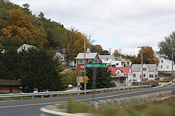 Location of De Soto, Wisconsin
Coordinates: 43°25′37″N 91°11′49″W / 43.42694°N 91.19694°WCoordinates: 43°25′37″N 91°11′49″W / 43.42694°N 91.19694°W Country United States State Wisconsin Counties Vernon, Crawford Area – Total 1.4 sq mi (3.6 km2) – Land 1.3 sq mi (3.3 km2) – Water 0.1 sq mi (0.2 km2) Elevation[1] 653 ft (199 m) Population (2000) – Total 366 – Density 283.6/sq mi (109.5/km2) Time zone Central (CST) (UTC-6) – Summer (DST) CDT (UTC-5) FIPS code 55-19850[2] GNIS feature ID 1563761[1] 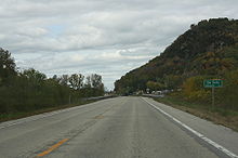 Looking northeast at the De Soto sign
De Soto is a village straddling Vernon and Crawford Counties in Wisconsin. The population was 366 at the 2000 census.
Contents
Geography
De Soto is located at 43°25′37″N 91°11′49″W / 43.42694°N 91.19694°W (43.426905, -91.196841).[3]
According to the United States Census Bureau, the village has a total area of 1.4 square miles (3.6 km²), of which, 1.3 square miles (3.3 km²) of it is land and 0.1 square miles (0.2 km²) of it (6.52%) is water.
Demographics
As of the census[2] of 2000, there were 366 people, 151 households, and 104 families residing in the village. The population density was 283.6 people per square mile (109.5/km²). There were 191 housing units at an average density of 148.0 per square mile (57.2/km²). The racial makeup of the village was 95.08% White, 1.64% African American, 0.55% Asian, 0.27% from other races, and 2.46% from two or more races. Hispanic or Latino of any race were 1.64% of the population.
There were 151 households out of which 26.5% had children under the age of 18 living with them, 61.6% were married couples living together, 4.0% had a female householder with no husband present, and 30.5% were non-families. 25.2% of all households were made up of individuals and 13.2% had someone living alone who was 65 years of age or older. The average household size was 2.42 and the average family size was 2.93.
In the village the population was spread out with 22.7% under the age of 18, 4.4% from 18 to 24, 23.5% from 25 to 44, 32.2% from 45 to 64, and 17.2% who were 65 years of age or older. The median age was 44 years. For every 100 females there were 89.6 males. For every 100 females age 18 and over, there were 88.7 males.
The median income for a household in the village was $33,036, and the median income for a family was $40,000. Males had a median income of $30,313 versus $16,250 for females. The per capita income for the village was $18,042. About 7.4% of families and 7.4% of the population were below the poverty line, including 13.7% of those under age 18 and 7.0% of those age 65 or over.
Education
The De Soto Area Schools serves De Soto, Wisconsin. [1]
References
- ^ a b "US Board on Geographic Names". United States Geological Survey. 2007-10-25. http://geonames.usgs.gov. Retrieved 2008-01-31.
- ^ a b "American FactFinder". United States Census Bureau. http://factfinder.census.gov. Retrieved 2008-01-31.
- ^ "US Gazetteer files: 2010, 2000, and 1990". United States Census Bureau. 2011-02-12. http://www.census.gov/geo/www/gazetteer/gazette.html. Retrieved 2011-04-23.
External links
Municipalities and communities of Vernon County, Wisconsin Cities 
Villages Towns Unincorporated
communitiesBloomingdale | Bud | Dilly | Esofea | Fargo | Kickapoo Center | Liberty Pole | Newry | Newton | Pleasant Valley | Purdy | Red Mound | Retreat | Rockton | Romance | Ross | Tunnelville‡ | Valley | Victory | West Prairie
Footnotes ‡This populated place also has portions in an adjacent county or counties
Categories:- Populated places in Vernon County, Wisconsin
- Villages in Wisconsin
- Populated places in Crawford County, Wisconsin


Wikimedia Foundation. 2010.