- Krakatoa
-
This article is about the volcano. For other uses, see Krakatoa (disambiguation).
Krakatoa 
An early 19th-century illustration of KrakatoaElevation 813 m (2,667 ft) Prominence 813 m (2,667 ft) Listing Spesial Ribu Location Location Indonesia Coordinates 6°06′07″S 105°25′23″E / 6.102°S 105.423°ECoordinates: 6°06′07″S 105°25′23″E / 6.102°S 105.423°E[1] Geology Type Caldera Last eruption 2011 Krakatoa (Indonesian: Krakatau) is a volcanic island made of a'a lava[2] in the Sunda Strait between the islands of Java and Sumatra in Indonesia. The name is used for the island group, the main island (also called Rakata), and the volcano as a whole. The island exploded in 1883, killing approximately 40,000 people, although some estimates put the death toll much higher. The explosion is considered to be the loudest sound ever heard in modern history, with reports of it being heard nearly 3,000 miles (4,800 km) from its point of origin. The shock wave from the explosion was recorded on barographs around the globe.
Contents
Historical significance
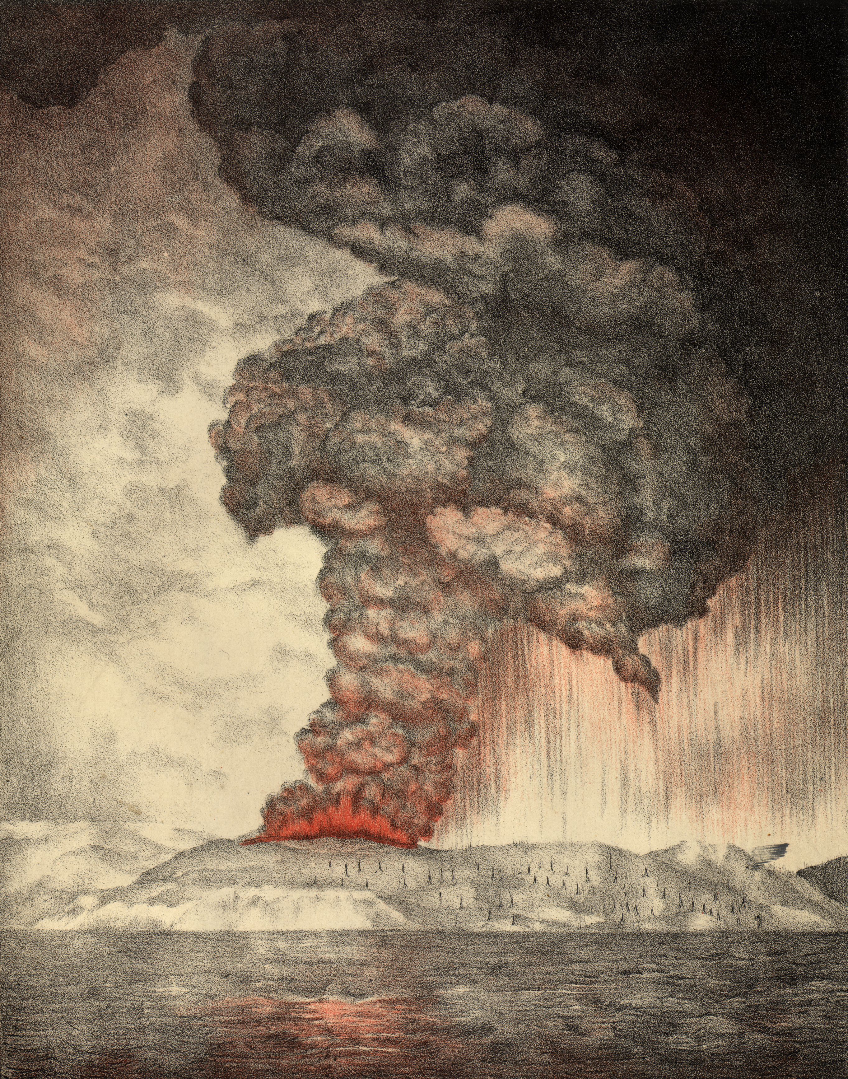
Further information: 1883 eruption of Krakatoa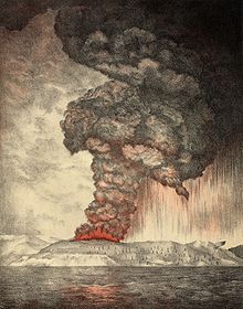 An 1888 lithograph of the 1883 eruption of Krakatoa.
The best known eruption of Krakatoa culminated in a series of massive explosions on August 26–27, 1883, which was among the most violent volcanic events in modern and recorded history.
With a Volcanic Explosivity Index (VEI) of 6,[3] the eruption was equivalent to 200 megatons of TNT (840 PJ) – about 13,000 times the nuclear yield of the Little Boy bomb (13 to 16 kt) that devastated Hiroshima, Japan, during World War II and four times the yield of the Tsar Bomba (50 Mt), the largest nuclear device ever detonated.
The 1883 eruption ejected approximately 21 km3 (5.0 cu mi) of rock, ash, and pumice.[4]
The cataclysmic explosion was faintly heard as far away as Perth in Western Australia, about 1,930 miles (3,110 km) away, and the island of Rodrigues near Mauritius, about 3,000 miles (5,000 km) away.[5]
Near Krakatoa, according to official records, 165 villages and towns were destroyed and 132 seriously damaged, at least 21,007 (official toll) people died, and many thousands were injured by the eruption, mostly from the tsunamis that followed the explosion. The eruption destroyed two-thirds of the island of Krakatoa.
Eruptions at the volcano since 1927 have built a new island in the same location, named Anak Krakatau (which is Indonesian for "Child of Krakatoa"). This island currently has a radius of roughly 2 kilometres (1.2 mi) and a high point around 324 metres (1,063 ft) above sea level [6], growing 5 metres (16 ft) each year.[7]
Etymology and orthography
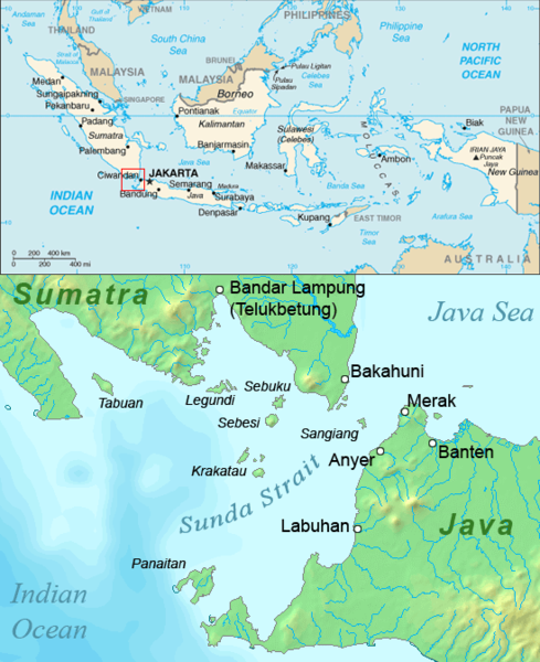
 The Sunda Strait
Although there are earlier descriptions of an island in the Sunda Strait with a "pointed mountain," the earliest mention of Krakatoa by name in the Western world was on a 1611 map by Lucas Janszoon Waghenaer, who labeled the island "Pulo Carcata." (Pulo is a form of pulau, the Indonesian word for "island"). About two dozen variants have been found, including Crackatouw, Cracatoa, and Krakatao (in an older Portuguese-based spelling). The first known appearance of the spelling Krakatau was by Wouter Schouten, who passed by "the high tree-covered island of Krakatau" in October 1658.[citation needed]
The origin of the Indonesian name Krakatau is uncertain. The main theories are:
- Onomatopoeia, imitating the noise made by cockatoos (Kakatoes) which used to inhabit the island. However, Van den Berg points out that these birds are found only in the "eastern part of the archipelago" (meaning the Lesser Sundas, east of Java). (See Wallace Line).
- From Sanskrit karka or karkata or karkataka, meaning "lobster" or "crab". (Rakata also means "crab" in the older Javan language.) This is considered the most likely origin.
- The closest Malay word is kelakatu, meaning "white-winged ant". Furneaux points out that in pre-1883 maps, Krakatoa does somewhat resemble an ant seen from above, with Lang and Verlaten lying to the sides like wings.
- Van den Berg (1884) recites a story that Krakatau was the result of a linguistic error. According to the legend, a visiting ship's captain asked a local inhabitant the island's name, and the latter replied, "Kaga tau" (Aku nggak tau)—a Jakartan/Betawinese slang phrase meaning "I don't know". This story is largely discounted; it closely resembles other linguistic myths about the origin of the word kangaroo and the name of the Yucatán Peninsula.
The Smithsonian Institution's Global Volcanism Program cites the Indonesian name, Krakatau, as the correct name but says that Krakatoa is often employed.[7] This has been attributed to a sub-editor at The Times (who may have typographically swapped the 'a' and 'o' of the Portuguese spelling) interpreting telegraphic reporting on the massive eruption of 1883.[8] Also, like Egypt a couple of decades earlier, Polynesia (South Pacific) was in vogue in the late 19th century, and the Polynesian-like suffix -oa (as in Samoa) may have caught on as a result.[citation needed] While Krakatoa is more common in the English-speaking world, the Indonesian Krakatau tends to be favored by others, including geologists. Rogier Verbeek seems to have started the modern convention of using Krakatau for the island proper and reserving Rakata for the main cone.[citation needed]
Geographical setting
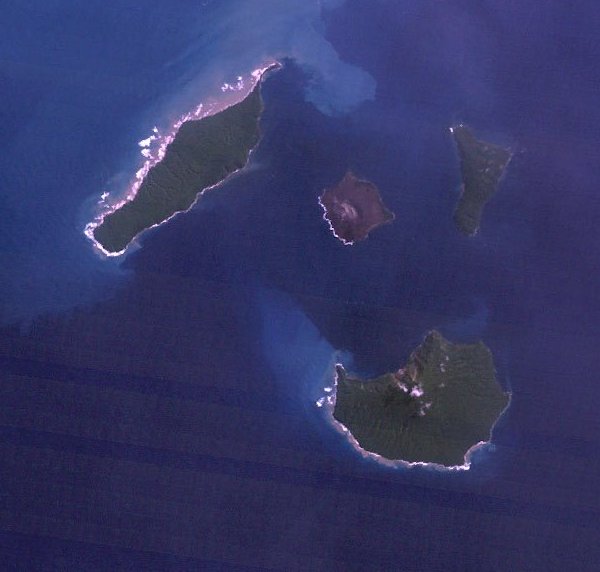
 Satellite view of Krakatau Islands, 18 May 1992.
Indonesia has over 130 active volcanoes,[9] the most of any nation. They make up the axis of the Indonesian island arc system, which was produced by northeastward subduction of the Indo-Australian Plate. A majority of these volcanoes lie along Indonesia's two largest islands, Java and Sumatra. These two islands are separated by the Sunda Straits, which are located at a bend in the axis of the island arc. Krakatoa is directly above the subduction zone of the Eurasian Plate and the Indo-Australian Plate where the plate boundaries make a sharp change of direction, possibly resulting in an unusually weak crust in the region.
Before the 1883 eruption, Krakatoa comprised three main islands: Lang ("long," now called Rakata Kecil, or Panjang), and Verlaten ("forsaken" or "deserted," now Sertung), which were edge remnants of a previous very large caldera-forming eruption; and Krakatoa itself, an island 9 km (5.6 mi) long by 5 km (3.1 mi) wide. Also there was a tree-covered islet near Lang named Poolsche Hoed ("Polish Hat," apparently because it looked like one from the sea) and several small rocks or banks between Krakatoa and Verlaten. There were three volcanic cones on Krakatoa: Rakata, (820 m/2,690 ft) to the south; Danan, (450 m/1,480 ft) to the north; and Perboewatan, (120 m/390 ft) to the north (Danan may have been a twin volcano).
Pre-1883 history
At some point in prehistory, an earlier caldera-forming eruption occurred, leaving as remnants Verlaten, Long, Poolsche Hoed, and the base of Rakata. Later, at least two more cones (Perboewatan and Danan) formed and eventually joined with Rakata, forming the main island of Krakatoa. The dating of these events is currently unknown; the Sunda Strait was first mentioned by Arab sailors around 1100 AD.
416 AD event
The Javanese Book of Kings (Pustaka Raja) records that in the year 338 Saka (416 AD):
A thundering sound was heard from the mountain Batuwara [now called Pulosari, an extinct volcano in Bantam, the nearest to the Sunda Strait] which was answered by a similar noise from Kapi, lying westward of the modern Bantam [Bantam is the westernmost province in Java, so this seems to indicate that Krakatoa is meant]. A great glowing fire, which reached the sky, came out of the last-named mountain; the whole world was greatly shaken and violent thundering, accompanied by heavy rain and storms took place, but not only did not this heavy rain extinguish the eruption of the fire of the mountain Kapi, but augmented the fire; the noise was fearful, at last the mountain Kapi with a tremendous roar burst into pieces and sank into the deepest of the earth. The water of the sea rose and inundated the land, the country to the east of the mountain Batuwara, to the mountain Rajabasa [the most southerly volcano in Sumatra], was inundated by the sea; the inhabitants of the northern part of the Sunda country to the mountain Rajabasa were drowned and swept away with all property[10] ... The water subsided but the land on which Kapi stood became sea, and Java and Sumatra were divided into two parts.
There is no geological evidence of a Krakatoa eruption of this size around that time; it may describe loss of land which previously joined Java to Sumatra across what is now the narrow east end of the Sunda Strait; or it may be a mistaken date, referring to an eruption in 535 AD, for which there is some corroborating historical evidence.[11]
535 AD event
David Keys, Ken Wohletz, and others have postulated that a violent volcanic eruption, possibly of Krakatoa, in 535 may have been responsible for the global climate changes of 535–536.[11] Keys explores what he believes to be the radical and far-ranging global effects of just such a putative 6th-century eruption in his book Catastrophe: An Investigation into the Origins of the Modern World. Additionally, in recent times, it has been argued that it was this eruption which created the islands of Verlaten, Lang, and the beginnings of Rakata—all indicators of early Krakatoa's caldera's size. To date, however, little datable charcoal from that eruption has been found.
Thornton (p. 47) mentions that Krakatoa was known as "The Fire Mountain" during Java's Sailendra dynasty, with records of seven eruptive events between the 9th and 16th centuries. These have been tentatively dated as 850, 950, 1050, 1150, 1320, and 1530 (all AD).
1680
In February 1681, Johann Wilhelm Vogel, a Dutch mining engineer at Salida, Sumatra (near Padang), on his way to Batavia (modern Jakarta) passed through the Sunda Strait. In his diary he wrote:
... I saw with amazement that the island of Krakatoa, on my first trip to Sumatra [June 1679] completely green and healthy with trees, lay completely burnt and barren in front of our eyes and that at four locations was throwing up large chunks of fire. And when I asked the ship's Captain when the aforementioned island had erupted, he told me that this had happened in May 1680 ... He showed me a piece of pumice as big as his fist.
Vogel spent several months in Batavia, returning to Sumatra in November 1681. On the same ship were several other Dutch travellers, including Elias Hesse, who would be called a travel writer nowadays. Hesse's journal reports that on
the 19th [of November 1681] we again lifted anchor and proceeded first to the north of us to the island of Sleepzie [ Sebesi ], uninhabited, ... [here he tells of a legend about crying ghosts, which actually were orangutans ], and then still north of the island of Krakatou, which erupted about a year ago and also is uninhabited. The rising smoke column of this island can be seen from miles away; we were with our ship very close to shore and we could see the trees sticking out high on the mountain, and which looked completely burned, but we could not see the fire itself.
Vogel returned to Amsterdam in 1688 and published the first edition of his journal in 1690.
These reports of an eruption in 1680–81 pose something of a puzzle. These are the only two reports of an eruption that have been found to date, yet at the time, the Sunda Strait was one of the heaviest-travelled waterways in the world. Records for this time period are particularly detailed, because there was an intense effort to wipe out pirates that were preying on vessels in the Strait. Neither Vogel nor Hesse mention Krakatoa in any real detail in their other passings, and no other travellers at the time mention an eruption or evidence of one. (In November 1681, a pepper crop was being offered for sale.) Both Van den Berg and Verbeek conclude from this that Vogel must have exaggerated the extent of the eruption he saw. Even so, there must have been an eruption around this time, since in 1880, Verbeek investigated a fresh unweathered lava flow at the northern coast of Perboewatan, which could not have been more than a couple of centuries old.
Visit by HMS Discovery
In February 1780 the crews of HMS Resolution and HMS Discovery, on the way home after Captain James Cook's death in Hawaiʻi, stopped for a few days on Krakatoa. They found two springs on the island, one fresh water and the other hot. They described the natives who then lived on the island as "friendly" and made several sketches. (In his journal, John Ledyard calls the island "Cocoterra.")
Dutch activity
In 1620 the Dutch set up a naval station on the islands and somewhat later a shipyard was built. Sometime in the late 17th century an attempt was made to establish a pepper plantation on Krakatoa but the islands were generally ignored by Dutch colonial authorities. In 1809 a penal colony was established at an unspecified location which was in operation for about a decade. By the 1880s the islands were without permanent inhabitants; the nearest settlement was the nearby island of Sebesi (about 12 km away) with a population of about 3,000.
Several surveys and charts were made, but mainly for the purpose of mariners, and the islands were little explored or studied. An 1854 map of the islands was used in an English chart, which shows some difference from a Dutch chart made in 1874. In July 1880, Rogier Verbeek made an official survey of the islands but he was only allowed to spend a few hours there. He was able to collect samples from several places and his investigation proved important in judging the geological impact of the 1883 eruption.[12]:9
The 1883 eruption
Main article: 1883 eruption of Krakatoa Evolution of the islands around Krakatoa (French).
While seismic activity around the volcano was intense in the years preceding the cataclysmic 1883 eruption, a series of lesser eruptions beginning in mid-June 1883 led up to the disaster. The volcano released huge plumes of steam and ash lasting until late August.
On August 27 a series of four huge explosions almost entirely destroyed the island. The explosions were so violent that they were heard 3,500 km (2,200 mi) away in Perth, Western Australia and the island of Rodrigues near Mauritius, 4,800 km (3,000 mi) away.[5] The pressure wave from the final explosion was recorded on barographs around the world, which continued to register it up to 5 days after the explosion. The recordings show that the shockwave from the final explosion reverberated around the globe 7 times in total.[12] Ash was propelled to a height of 80 km (50 mi). The sound of the eruption was so loud it was said that if one was within ten miles (16 km), they would go deaf.
The combined effects of pyroclastic flows, volcanic ashes, and tsunamis had disastrous results in the region. The official death toll recorded by the Dutch authorities was 36,417, although some sources put the estimate at more than 120,000. There are numerous documented reports of groups of human skeletons floating across the Indian Ocean on rafts of volcanic pumice and washing up on the east coast of Africa up to a year after the eruption.
Average global temperatures fell by as much as 1.2 degrees Celsius in the year following the eruption. Weather patterns continued to be chaotic for years and temperatures did not return to normal until 1888.
Subsequent volcanism
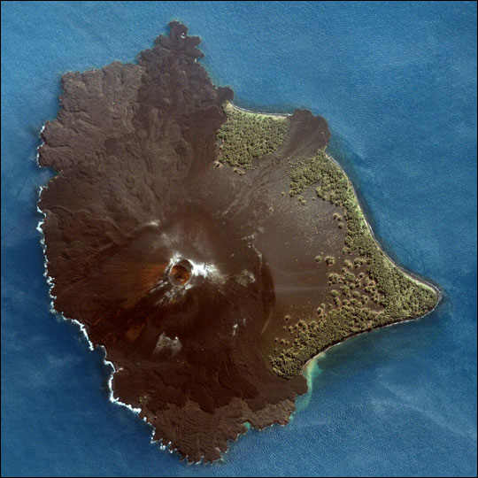
Anak Krakatau
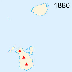
Verbeek, in his report on the eruption, predicted that any new activity would manifest itself in the region which had been between Perboewatan and Danan. This prediction came true on 29 December 1927, when evidence of a submarine eruption was seen in this area (an earlier event in the same area had been reported in June 1927). A new island volcano, named Anak Krakatau or Child of Krakatoa, rose above the waterline a few days later. The eruptions were initially of pumice and ash, and that island and the two islands that followed were quickly eroded away by the sea. Eventually a fourth island named Anak Krakatau broke water in August 1930 and produced lava flows faster than the waves could erode them. Of considerable interest to volcanologists, this has been the subject of extensive study.
-

A closer look at Anak Krakatau.
-

Volcanic activity at Anak Krakatau.
-

The thick brown plume of ash, steam and volcanic gas rising from Anak Krakatau in this true-colour satellite image is a common sight at the volcano.
Current activity
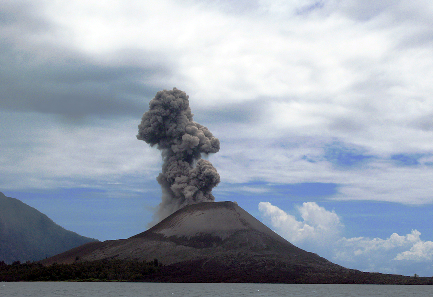
Anak Krakatau has grown at an average rate of five inches (13 cm) per week since the 1950s. This equates to an average growth of 6.8 meters per year. The island is still active, with its most recent eruptive episode having begun in 1994. Quiet periods of a few days have alternated with almost continuous Strombolian eruptions since then, with occasional much larger explosions.
The eruption in April 2008 saw hot gases, rocks, and lava released. Scientists monitoring the volcano have warned people to stay out of a 3 km zone around the island.[13] There are several videos of Krakatoa uploaded onto YouTube showing recent footage of it erupting[14] and inside its crater filmed at the edge of the volcano rim.[15]
On 6 May 2009 the Volcanological Survey of Indonesia raised the eruption alert status of Anak Krakatau to Level Orange.[16]
James Reynolds posted footage to YouTube[17] from as recently as November 1, 2010 showing some spectacular eruptions, and NASA has released satellite imagery[18] of the recent activity.
-

An eruption in Summer 1999.
-

An eruption in 2008.
Biological research
The islands have become a major case study of island biogeography and founder populations in an ecosystem being built from the ground up in an environment virtually cleaned.[19]
The islands had been little explored or surveyed before the 1883 catastrophe—only two pre-1883 biological collections are known: one of plant specimens and the other part of a shell collection. From descriptions and drawings made by the HMS Discovery, the flora appears to have been representative of a typical Javan tropical climax forest. The pre-1883 fauna is virtually unknown but was probably typical of the smaller islands in the area.
The Krakatau problem
From a biological perspective, the Krakatau problem[20] refers to the question of whether the islands were completely sterilized by the 1883 eruption or whether some life survived. When the first researchers reached the islands in May 1884, the only living thing they found was a spider in a crevice on the south side of Rakata. Life quickly recolonized the islands, however; Verbeek's visit in October 1884 found grass shoots already growing. The eastern side of the island has been extensively vegetated by trees and shrubs, presumably brought there as seeds washed up by ocean currents or carried in birds' droppings (or brought by natives and scientific investigators). It is, however, in a somewhat fragile position, and the vegetated area has been badly damaged by recent eruptions.
Handl's occupancy
A German, Johann Handl, obtained a permit to mine pumice in October 1916.[2] His lease of 8.7 square kilometres (3.4 sq mi), which was basically the eastern half of the island, was for 30 years. He occupied the south slope of Rakata from 1915 to 1917, when he left due to "violation of the terms of the lease." (Winchester gives the date of Handl's leaving as late 1917–1921.) Handl built a house and planted a garden with "4 European families and about 30 coolies". He is also believed to have introduced the black rat to the island. He also found unburned wood below the 1883 ash deposits when digging, and fresh water was found below 18 feet (5.5 m).
In media
Main articles: Krakatoa in media and popular culture and Krakatoa documentary and historical materialsSee also
- List of volcanic eruptions by death toll
- List of deadliest natural disasters
- List of volcanoes in Indonesia
- Timetable of major worldwide volcanic eruptions
- Krakatoa documentary and historical materials
- Krakatoa in media and popular culture
- Noctilucent cloud
- Plinian eruption
- San Benedicto Island
- Volcanic Explosivity Index (includes list of large eruptions)
References
Notes
- ^ Dunk, Marcus (2009-07-31). "Will Krakatoa rock the world again?". London: Associated Newspapers Ltd. http://www.dailymail.co.uk/news/worldnews/article-1203028/Fiery-images-killer-volcano-claimed-36-000-lives-stirs-more.html. Retrieved 2010-01-23.
- ^ a b Thornton, Ian W. B. (1997). Krakatau: the destruction and reassembly of an island ecosystem. Harvard University Press. ISBN 0674505727.
- ^ Breining, Greg (2007). "The Deadliest Volcanoes". Super Volcano: The Ticking Time Bomb Beneath Yellowstone National Park. Voyageur Press. p. 256. ISBN 978-0-7603-2925-2.
- ^ Hopkinson, Deborah (Jan 2004). The Volcano That Shook the world: Krakatoa 1883. 11. New York: Storyworks. p. 8. http://teacher.scholastic.com/activities/wwatch/volcanoes/witnesses.htm.
- ^ a b "How Krakatoa made the biggest bang". London: The Independent. 2006-05-03. http://news.independent.co.uk/world/science_technology/article361665.ece. Retrieved 2010-01-23.
- ^ "Anak Krakatau". http://www.gunungbagging.com/anak-krakatau. Retrieved 2011-11-10.
- ^ a b "Krakatau". Global Volcanism Program, Smithsonian Institution. http://www.volcano.si.edu/world/volcano.cfm?vnum=0602-00=.
- ^ Winchester 2003, p. 183.
- ^ "Volcanoes of Indonesia". Global Volcanism Program. Smithsonian Institution. http://www.volcano.si.edu/world/region.cfm?rnum=06&rpage=list. Retrieved 25 March 2007.
- ^ "Krakatau version 1.0, Part 2". The Anthropogene. 2003-11-11. http://webpages.charter.net/anthropogene/arc_vol1_is7.html. Retrieved 2010-01-23.
- ^ a b Wohletz KH, 2000, Were the Dark Ages triggered by volcano-related climate changes in the 6th century? EOS Trans Amer Geophys Union 48(890), F1305.
- ^ a b "Symons, G.J. (ed) ''The Eruption of Krakatoa and Subsequent Phenomena'' (Report of the Krakatoa Committee of the Royal Society). London, 1888". Books.google.com. 2007-10-16. http://books.google.com/books?id=Vk8PAAAAYAAJ. Retrieved 2011-03-17.
- ^ "Indonesia's Krakatau roars, dazzles with fireworks". Reuters India. 2007-11-11. http://in.reuters.com/article/worldNews/idINIndia-30436520071111?sp=true. Retrieved 2010-01-23.
- ^ "Anak Krakatoa from safer distance". YouTube. http://www.youtube.com/watch?v=FUF3aD-9av4&feature=related. Retrieved 2011-03-17.
- ^ "Krakatau". YouTube. 2010-11-01. http://www.youtube.com/watch?v=Qb8UJTbpm58. Retrieved 2011-03-17.
- ^ "VSI Alert". Volcanological Survey of Indonesia. http://portal.vsi.esdm.go.id/joomla/. Retrieved 2010-01-23.[dead link]
- ^ "Spectacular Explosive Eruptions at Anak Krakatau (Krakatoa) Volcano, Indonesia 1st Nov. 2010". YouTube. http://www.youtube.com/watch?v=nXzQT52Sdec. Retrieved 2011-03-17.
- ^ "NASA - Earth Observing-1: Ten Years of Innovation". Nasa.gov. http://www.nasa.gov/topics/earth/features/eo1-10th.html. Retrieved 2011-03-17.
- ^ Wilson, Edward. O. (1999). The Diversity of Life. New York, NY: W. W. Norton & Company. pp. 425. http://books.google.com/books?id=FzPaB_6Pw4MC&lpg=PP1&pg=PA16#v=onepage&q&f=false.
- ^ Backer, Cornells Andries (1929). The Problem of Krakatau, as Seen by a Botanist. author, at Weltevreden, Java.
Bibliography
- Alfred, E. & Seward, A.C.; The New Flora of the Volcanic Island of Krakatau, (reissued by Cambridge University Press, 2009, ISBN 9781108004336)
- Dickins, Rosie; The Children's Book of Art (An introduction to famous paintings) Usborne Publishing Ltd., Usborne House, 83–85 Saffron Hill, London ISBN 978-0-439-88981-0 (2005)
- Furneaux, Rupert; Krakatoa Secker and Warburg, London (1965)
- Self, Stephen & Rampino, Michael R. (1981). "The 1883 eruption of Krakatau". Nature 294 (5843): 699–704. doi:10.1038/294699a0.
- Simkin, Tom and Richard S. Fiske (editors); Krakatau, 1883—the volcanic eruption and its effects Smithsonian Institution Press, Washington, D.C. ISBN 0-87474-841-0 (1983)
- Symons, G.J. (ed); The Eruption of Krakatoa and Subsequent Phenomena (Report of the Krakatoa Committee of the Royal Society) London (1888)
- Thornton, Ian; Krakatau: The Destruction and Reassembly of an Island Ecosystem (1996)
- Verbeek, R. D. M. (1884). "The Krakatoa eruption". Nature 30 (757): 10–15. doi:10.1038/030010a0.
- Verbeek, Rogier Diederik Marius; Krakatau Batavia (1885)
- Winchester, Simon (2003). Krakatoa: The Day the World Exploded: August 27, 1883. New York: HarperCollins. ISBN 0066212855.
- Wilson, Edward O. (1999). The Diversity of Life. New York, NY: W. W. Norton & Company. pp. 425. ISBN 0-393-31940-7. http://books.google.com/books?id=FzPaB_6Pw4MC&lpg=PP1&pg=PA16#v=onepage&q&f=false.
External links
- Krakatau 2010
- Krakatau image gallery from Volcano World, a Public Outreach project of the North Dakota and Oregon Space Grant Consortia, administered by the Department of Geosciences at Oregon State University
- Photos of Krakatoa from 2004 to 2009
- "In het Rijk van Vulcaan" – "In the Realm of the Volcano", eyewitness account by R.A. van Sandick (Dutch)
- Natural wonders: Krakatau[dead link] – basic information about the 1883 eruption from the University of South Florida
- 1883 Eruption of Krakatau from the United States Geological Survey's Cascades Volcano Observatory
- Krakatau, Indonesia (1883) – information from San Diego State University about the 1883 eruption
- Krakatoa Volcano: The Son Also Rises – companion website to the NPR programme
- On-line images of some of Ashcroft's sunset sketches
- BBC World Service programme 'Witness' talks to Simon WInchester
Java Ancol Dreamland · Anyer · Bogor Palace · Borobudur · Dieng Volcanic Complex · G-Land · Istiqlal Mosque · Karimunjawa National Park · Kawah Putih · Kraton Ngayogyakarta Hadiningrat · Kukup Beach · Mount Bromo · Mount Merapi · Ngliyep Beach · Pangandaran · Parangtritis Beach · Patenggang Lake · Pelabuhan Ratu · Prambanan · Puncak · Suramadu Bridge · Tangkuban Perahu · Tanjung Lesung Beach · Thousand Islands · TMII · Trans Studio Bandung · Ujung Kulon National Park · Umang IslandKalimantan Sulawesi Bantimurung - Bulusaraung · Bunaken National Marine Park · Losari Beach · Taka Bone Rate · Tempe Lake · Tondano Lake · Toraja · Trans Studio Makassar · WakatobiLesser Sunda Islands Bedugul · Dreamland Beach · Gili Air · Gili Meno · Gili Trawangan · Jimbaran · Kelimutu Lake · Komodo Island · Kuta (Bali) · Kuta (Lombok) · Lovina Beach · Mount Rinjani · Mount Tambora · Moyo Island · Nusa Dua · Nusa Lembongan · Rinca Island · Sanur · Segara Anak Lake · Seminyak · Senggigi · Tampaksiring · Tanah Lot · Ubud · UluwatuMaluku and Papua Categories:- Volcanic calderas of Indonesia
- Subduction volcanoes
- Active volcanoes of Indonesia
- Mountains of Indonesia
- Uninhabited islands of Indonesia
- VEI-6 volcanoes
- 1883 natural disasters
- Sunda Strait
- Krakatoa
- Submarine calderas


Wikimedia Foundation. 2010.