- Mississippi River Delta
-
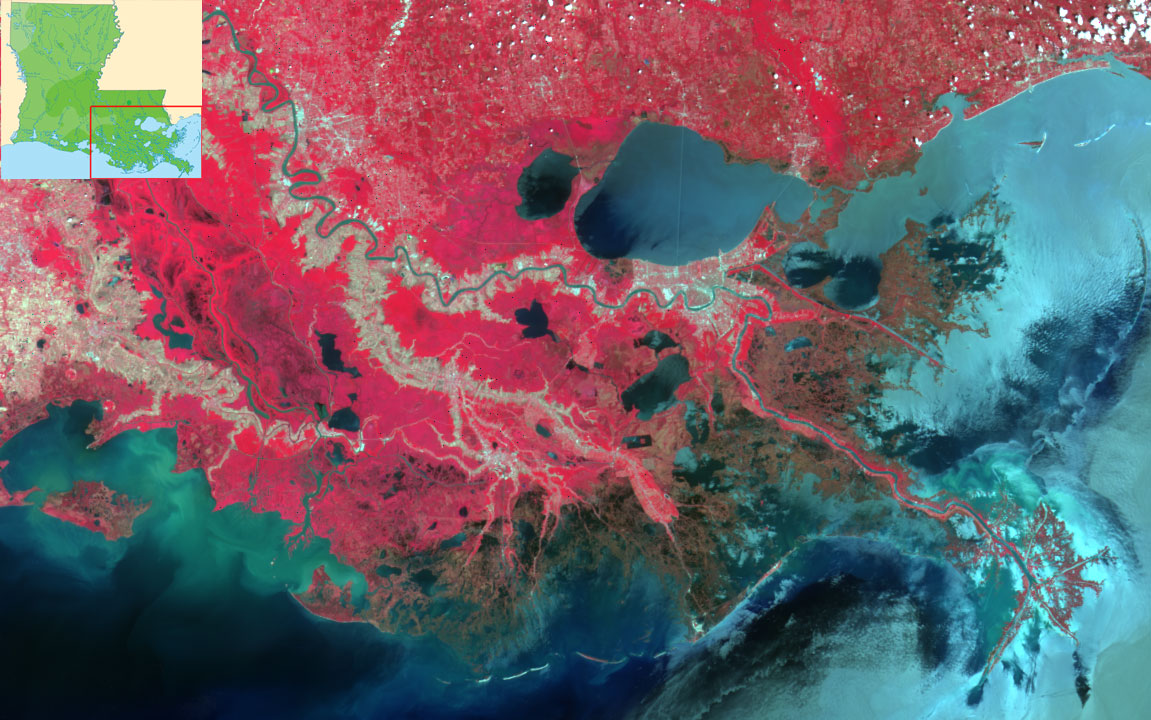
 False-color image of the larger Mississippi River Delta
The Mississippi River Delta is the modern area of land (the river delta) built up by alluvium deposited by the Mississippi River as it slows down and enters the Gulf of Mexico. The deltaic process has, over the past 5,000 years, caused the coastline of south Louisiana to advance gulfward from 15 to 50 miles (24 to 80 km).
It is a biologically significant region, comprising 3 million acres (12,000 km²) of coastal wetlands and 40% of the salt marsh in the contiguous United States. It is also a commercially significant region, supporting the economy of New Orleans with significant shipping traffic, providing 16 to 18% of the oil supply in the U.S., and providing 16% of the fisheries harvest in the U.S., including shrimp, crabs, and crayfish.
The Mississippi River Delta is not to be confused with the Mississippi Delta region, an alluvial plain located some 300 miles (480 km) northward in western Mississippi along the river.
Contents
Recent influences
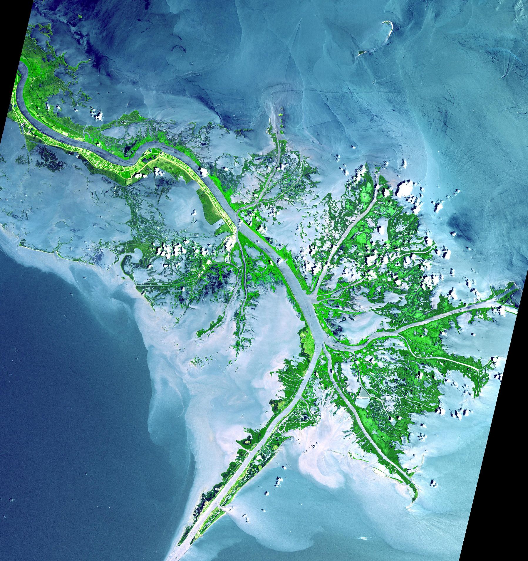
 The Mississippi River Delta, showing the sediment plumes from the Mississippi and Atchafalaya Riltaic Rivers, 2001.
About every thousand years, the Mississippi River has changed course. Each Mississippi River deltaic cycle was initiated by a gradual capture of the Mississippi River by a distributary which offered a shorter and steeper route to the Gulf of Mexico. After abandonment of an older delta lobe, which would cut off the primary supply of fresh water and sediment, an area would undergo compaction, subsidence, and erosion. The old delta lobe would begin to retreat as the gulf advanced, forming bayous, lakes, bays, and sounds. The river has been diverting more of its flow to the Atchafalaya River, which branches off some 60 miles (95 km) northwest of New Orleans. In the mid-20th century, engineers observed that the Mississippi would soon abandon its current channel as the mainstream, and instead migrate to the Atchafalaya Basin.[1]
Because there is extensive economic development along the current path of the Mississippi, and because extensive flooding and evacuation would occur in the new area, Congress instructed the Army Corps of Engineers to maintain the then-present 70% / 30% distribution of water between the Lower Mississippi and the Atchafalaya River channels, respectively. They did so by building the Old River Control Structure, which consisted of massive floodgates that could be opened and closed as needed at the entrance to the Old River.
Manmade changes to other parts of the Mississippi River have had a pronounced effect on the Delta region. Dams, artificial channeling, and land conservation measures have caused a decrease in sediment carried into the delta region, decreasing the rate of build up of the Delta. The currently active lobe is called the Birdfoot (after its shape) or Balize Delta (after the first French settlement La Balize at the mouth of the river). It has been active for 600-800 years.[2]
Extensive oil and gas extraction has also resulted in subsidence of the delta and wetlands causing the loss of 34 square miles (88 km2) of land every year. Since 1930, Louisiana has lost 1,200,000 acres (4,900 km2) of coastline.
At the same time, the rate of loss of the Delta has recently increased past the rate of build up, causing a net loss of wetlands in the Delta area. The rise in sea level has caused increased erosion, as the fresh water vegetation that previously protected against erosion dies due to the influx of salt water. Subsidence has increased.
History
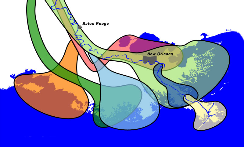
See also: La Balize, Louisiana Mississippi Delta lobes
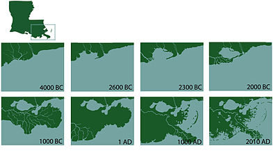 Coastal Change in South Eastern Louisiana
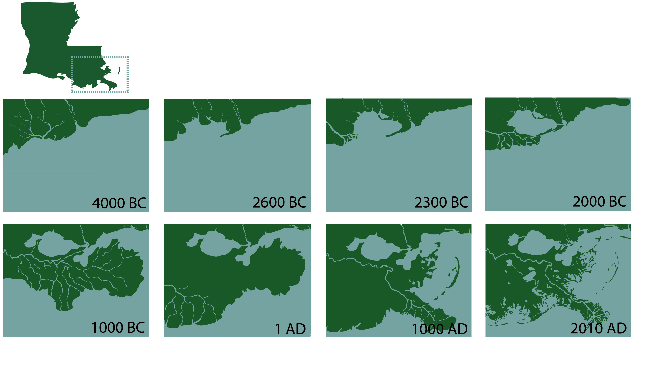
Build-up of the Gulf of Mexico shoreline due to the outflow of the Mississippi River has been occurring in a periodic fashion since the late Jurassic period. This same process is responsible for build up of the larger Mississippi embayment; however, the delta region is the most recent and ecologically distinct portion.
The latest cycle of delta movement can be traced to the Pleistocene epoch, when a large amount of ocean water was tied up in glaciers. The sea level was 300-400 feet (~100m) below present level, and causing the mouth of the Mississippi to be located further out into the Gulf of Mexico. 10,000 years ago, the glaciers began to melt, and the sea level began to rise. 5,000 - 6,000 years ago, the sea level stabilized, and formation of recognizable modern deltas began.
Lake Pontchartrain was formed during the evolution of two separate delta lobes. 4000-3800 years ago, the Cocodrie lobe * expanded over the area where New Orleans presently resides, forming the lake's southern shore. 2800-2600 years ago, the St. Bernard lobe * pushed forward and completed the lake's eastern shoreline.[3] Lafourche delta lobe (shown in blue) was the youngest abandoned lobe. It reached just south of where Venice is today.[4] The active Birdfoot or Balize delta lobe is shown in cream on the image.
In 1699 the French built their first crude fort at La Balize, on the Southeast Pass in Pass á Loutre, to control passage on the Mississippi. By 1721 they had built the wooden lighthouse-type structure (la balise means seamark in French) that gave the settlement its name. Built in the marshes, the village was vulnerable to hurricane damage. In addition, ships had to deal with the shifting conditions of tides, currents and mudflats through the mouth of the delta. From 1700 to 1888, the main shipping channel was changed four times in response to shifting sandbars, mudflats and hurricanes.[5] La Balize was moved by 1853 to the Southwest Pass when that became the main shipping channel, then rebuilt at Pilottown about five miles (8 km) upriver above Head of Passes after being destroyed by a hurricane. The Southwest Pass is currently the main shipping channel, with secondary uses at the South Pass and Pass á Loutre.[5]
See also
Notes
- ^ Interactive and zoomable map or satellite photos comparing the current channel, the potential new channel, and the various control structures
- ^ "Mississippi River Delta, USA", Geomorphology, NASA: Goddard Earth Sciences Data and Information Services Center, accessed 2008-05-14.
- ^ Overview of Geologic History, US Geological Survey.
- ^ Mississippi River Delta, USA; NASA: Goddard Earth Sciences Data and Information Services Center [1], accessed 2008-04-14.
- ^ a b Jiyu Chen, Engineered Coasts, New York: Springer, 2002, p. 67.
References
- Kolb, van Lopik (1958). Geology of the Mississippi River deltaic plain, southeastern Louisiana. Technical Report 3-483. Vicksburg, MS: U.S. Army Corps of Engineers Waterways Experiment Station. (PDF, 6.86MB) [2]
- LA Coast / USGS — Mississippi River Delta Basin
- Emporia State University — The Mississippi Embayment, Quaternary Geology
- USGS, Status and Trends — Coastal Louisiana
- Detrital Depositional Sequences of the Mississippi River Deltaic Plain, George F. Hart, Ph. D.
- USGS — Geologic History of the Lake Pontchartrain Basin
- Louisiana State University — Wetlands: Impacts of Energy Development in the Mississippi Delta
- USGS — Louisiana Coastal Area - Ecosystem Restoration Plan
External links
- Google Maps - satellite imagery
- US Army Corps of Engineers, New Orleans District
- U.S. Geological Survey - Mississippi Delta, Changes Over Time
- U.S. Geological Survey - Causes of hot-spot wetland loss in the Mississippi delta plain
- U.S. Geological Survey - Louisiana Coastal Wetlands: A Resource At Risk
- NOW with Bill Moyers - Losing Ground
- Interactive graphic of "The Rise and Disappearance of Southeast Louisiana" from The Times-Picayune
- visibleearth.nasa.gov - True-color image hilighting sediment outflow from delta front
- lacoast.gov - Land loss map of the delta front
- Barataria Terrebonne National Estuary
- Coastal Louisiana Ecosystem Assessment & Restoration
- The End of the Great River: Photographs of the Lower Mississippi River Delta
Categories:- Mississippi River
- River deltas
- Wetlands and bayous of Louisiana
Wikimedia Foundation. 2010.