- Dutch Harbor Naval Operating Base and Fort Mears, U.S. Army
-
Dutch Harbor Naval Operating Base and Fort Mears, U.S. Army
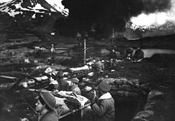 Japanese attack on Dutch Harbor, June 3, 1942. Group of Marines on the alert between attacks

Location: Dutch Harbor, Unalaska, Alaska Coordinates: 53°54′6″N 166°31′55″W / 53.90167°N 166.53194°WCoordinates: 53°54′6″N 166°31′55″W / 53.90167°N 166.53194°W Built: 1940 Governing body: Private NRHP Reference#: 85002733 Significant dates Added to NRHP: February 4, 1985[1] Designated NHLD: February 4, 1985[2] Dutch Harbor Naval Operating Base and Fort Mears are the two military installations built next to each other in Dutch Harbor, Alaska, by the United States in response to the growing war threat with Japan. A 1938 Navy board recommended the construction which began in July 1940.[3] The first army troops arrived in June 1941 and the Navy air base was finished in September 1941. At the time of the attack on Pearl Harbor, these two bases were the only military installations in the Aleutian Islands.
Contents
Battle of Dutch Harbor
Main article: Battle of Dutch HarborOn June 3, 1942, the Japanese navy attacked Dutch Harbor. Originally planned to start at the same time as the battle of Midway, it occurred a day earlier due to one-day delay in the sailing of Nagumo's task force.[4] 43 Americans and at least one Japanese died during the attacks, which lasted for two days. The base remained an important part of coastal defenses for the remainder of World War II.[5]
Postwar
Shortly after the end of World War II, the US military abandoned their Dutch Harbor outposts. For decades afterwards, the buildings remained standing, generally abandoned. With the growth of the king crab fishery in the 1970s, many of these buildings were called into use as warehouses, bunkhouses, and family homes.
In the late 1980s, the US government finally funded a cleanup of the derelict fort, and the area was turned over for commercial use.
See also
Aleutian World War II National Historic Area
References
- ^ "National Register Information System". National Register of Historic Places. National Park Service. 2008-04-15. http://nrhp.focus.nps.gov/natreg/docs/All_Data.html.
- ^ "Dutch Harbor Naval Operating Base and Fort Mears, U.S. Army". National Historic Landmark summary listing. National Park Service. http://tps.cr.nps.gov/nhl/detail.cfm?ResourceId=1913&ResourceType=District. Retrieved 2008-07-03.
- ^ NPS Aviation History
- ^ Parshall and Tully, Shattered Sword, pp. 43–45, derived from Senshi Sōshō, pp. 119–121.
- ^ NPS NHL Description
U.S. National Register of Historic Places Topics Lists by states Alabama • Alaska • Arizona • Arkansas • California • Colorado • Connecticut • Delaware • Florida • Georgia • Hawaii • Idaho • Illinois • Indiana • Iowa • Kansas • Kentucky • Louisiana • Maine • Maryland • Massachusetts • Michigan • Minnesota • Mississippi • Missouri • Montana • Nebraska • Nevada • New Hampshire • New Jersey • New Mexico • New York • North Carolina • North Dakota • Ohio • Oklahoma • Oregon • Pennsylvania • Rhode Island • South Carolina • South Dakota • Tennessee • Texas • Utah • Vermont • Virginia • Washington • West Virginia • Wisconsin • WyomingLists by territories Lists by associated states Other  Category:National Register of Historic Places •
  Portal:National Register of Historic PlacesCategories:
- Historic districts in Alaska
- Aleutians West Census Area, Alaska
- National Historic Landmarks in Alaska
- Closed facilities of the United States Navy
- Alaska Registered Historic Place stubs


Wikimedia Foundation. 2010.