- Dove Holes
-
Coordinates: 53°17′N 1°53′W / 53.29°N 1.89°W
Dove Holes 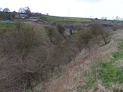
This old quarry railway passes under the A6 via the bridge, close to its junction with the still extant main Buxton-Manchester line. The farm at the top left is Hallsteads Farm.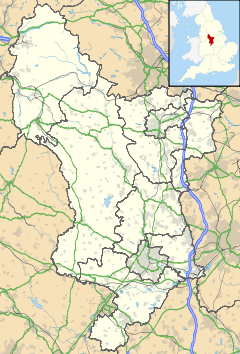
 Dove Holes
Dove Holes shown within DerbyshireOS grid reference SK074781 District High Peak Shire county Derbyshire Region East Midlands Country England Sovereign state United Kingdom Post town BUXTON Postcode district SK17 Dialling code 01298 Police Derbyshire Fire Derbyshire Ambulance East Midlands EU Parliament East Midlands UK Parliament High Peak List of places: UK • England • Derbyshire Dove Holes is a village in the High Peak district of Derbyshire, England. It has a population of about 1,200. It straddles the A6 road and it lies three miles from Buxton and three miles from Chapel-en-le-Frith. Trains run from Dove Holes railway station into Manchester.
Residents of the village live either in the village or on outlying farms. There are around six farms in the village and many more within the boundaries of the parish. There are also large limestone quarries that, over the years, have made an important contribution to the development and economy of the village. Additionally, there are several businesses, a general store and a post office. There are two public houses, one of which offers accommodation. There is a daily milk delivery service and a mobile library every fortnight. There is a church, Methodist chapel and a community centre. The village lies on the fringe of the Peak District National Park.
Evidence of human occupation at Dove Holes can be traced back to the Neolithic Period (late Stone Age) because of the existence of a henge, known locally as The Bull Ring, and an adjoining tumulus. In medieval times the area was used as the royal hunting Forest of High Peak (now known as Peak Forest), an area set aside as a royal hunting forest. The village's name is believed to derive from the Celtic word dwfr (dwr in modern Welsh), which means water, hence Water Holes or Dove Holes. The same word is the origin of the name 'Dover' for the famous Channel ferryport.
In 1650, a General Survey of the Manor of High Peak was made to assess the property of the late King Charles. This recorded that people were burning limestone around the village and that there were 14 kilns thereabouts, the burnt lime (quicklime) being slaked and used by farmers to condition the soil in their fields. At that time, lime kilns could be built and demolished without authority.
With the coming of the Industrial Revolution, and the opening of the Peak Forest Tramway in 1796, the limestone quarries were commercialised. The first of these was at nearby Loads Knowl and others quickly followed along Dove Holes Dale. Undoubtedly, the opening of the Peak Forest Tramway and the consequent expansion of commercial limestone quarries contributed greatly to the expansion of the village. For the first time, there was an outlet for limestone in Manchester via the Peak Forest Tramway, Bugsworth Basin, the Peak Forest Canal and the Ashton Canal.
There is a Trent Barton bus garage on the east side of the A6, replacing the one which used to be in Buxton.
In 2001, the village was voted the Ugliest Village in Britain.[1]
Cemex operate a quarry in Dove Holes.
References
External links
 Media related to Dove Holes at Wikimedia CommonsCategories:
- Villages in Derbyshire
- Towns and villages of the Peak District


Wikimedia Foundation. 2010.