- Long Branch, Toronto
Infobox City
official_name = Long Branch
subdivision_type2 = Country
subdivision_name2 =Canada
subdivision_type1 = Province
subdivision_name1 =Ontario
subdivision_type = City
subdivision_name =Toronto 
mapsize=150px
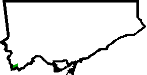
map_caption=Location of Long Branch within Toronto
established_title = Annexed
established_date = 1967 into EtobicokeLong Branch is a neighbourhood in the extreme southwestern section of
Toronto ,Ontario ,Canada . It was formerly part of the City ofEtobicoke , and prior to that was an independent municipality. The area is bounded byLake Ontario on the south,Etobicoke Creek to the west, theCanadian National railway to the north and Twenty-Third Street to the east.History
In the late 19th and early 20th century, Long Branch was a popular summer
resort destination for Torontonians. The area was served by steamers that sailed from the foot ofBay Street . A popular summer resort, built in apagoda style, was located at Long Branch Avenue and Lake Promenade, until it was destroyed byfire in the 1950s.In 1954, more than forty homes in Long Branch were demolished at the mouth of the Etobicoke Creek by
Hurricane Hazel . To prevent any futureflood s from having similar disastrous results, houses from around the mouth of the creek were relocated, and the area turned into a park. In 1959, the park was named for Marie Curtis in recognition for her efforts to have it built.Adjacent to the park is a closed site which was formerly the Long Branch
munitions factory during the 1940s. Huge quantities ofweapon s were manufactured there during theSecond World War , such as theBren ,Sten andLee Enfield . As of 2005 there are plans to incorporate the former munitions factory site into the Marie Curtis Park.In 1967, the
Village of Long Branch was amalgamated with the Township ofEtobicoke and theTown s ofNew Toronto andMimico to form the Borough of Etobicoke. The Borough became the City of Etobicoke in 1984. In 1998, Etobicoke was merged with five other municipalities and theMetropolitan Toronto government to form the new City of Toronto.Prominent reeves of the village included Marie Curtis (1954-1962), Leonard E. Ford (1963-1964), and Thomas Berry (1965-1966).
Character
It is generally considered to be an attractive neighbourhood to live in due to its proximity to downtown
Toronto , Lake Ontario, and many beautiful lakeside parks.ee also
*
List of neighbourhoods in Toronto External links
* [http://www.toronto.ca/demographics/cns_profiles/cns19.htm Long Branch neighbourhood profile]
* [http://www.pbase.com/mrclark/long_branch_factory Various photos of the Long Branch munitions factory]
* [http://www.toronto.ca/toronto_history/mayors_reeves/reeve_longbranch.htm The Village of Long Branch - Reeves]Toronto Neighbourhood Geography
North =Alderwood, Toronto
East =New Toronto
South = Lake Ontario
West =Mississauga, Ontario
Center = Long Branch
Wikimedia Foundation. 2010.
