- Kirklees
-
For the medieval village of the same name, see Kirklees, West Yorkshire.
Coordinates: 53°35′35″N 1°48′04″W / 53.593°N 1.801°W
Metropolitan Borough of Kirklees — Metropolitan borough — 
Coat of Arms of the Borough Council
Sovereign state United Kingdom Constituent country England Region Yorkshire and the Humber Ceremonial county West Yorkshire Founded Admin. HQ Huddersfield Government - Type Kirklees Metropolitan Council - Mayor: Cllr. Eric Firth - Chief Executive: Adrian Lythgo - Executive: Labour (council NOC) - MPs: Jason McCartney,
Simon Reevell,
Barry Sheerman,
Mike WoodArea - Total 157.8 sq mi (408.6 km2) Area rank 100th Population (2010 est.) - Total 409,800 - Rank Ranked 11th - Density 2,597.6/sq mi (1,002.9/km2) Time zone Greenwich Mean Time (UTC+0) - Summer (DST) British Summer Time (UTC+1) Postcode ISO 3166-2 ONS code 00CZ OS grid reference NUTS 3 Ethnicity 84.5 White
11.7% S.Asian
1.6% Black
1.6% Mixed
Chinese or other 0.5%[1]Website kirklees.gov.uk The Metropolitan Borough of Kirklees is a metropolitan borough of West Yorkshire, England. It has a population of 401,000 and includes the settlements of Batley, Birstall, Cleckheaton, Denby Dale, Dewsbury, Heckmondwike, Holmfirth, Huddersfield, Kirkburton, Marsden, Meltham, Mirfield and Slaithwaite. Huddersfield is the largest settlement of the district, and its centre of administration.
Contents
History
The borough was formed under the Local Government Act 1972 on 1 April 1974, by a merger of the county boroughs of Dewsbury and Huddersfield along with the municipal boroughs of Batley and Spenborough and the urban districts of Colne Valley, Denby Dale, Heckmondwike, Holmfirth, Kirkburton, Meltham and Mirfield.
The name "Kirklees" was chosen by the merging councils from more than fifty suggestions, including "Upper Agbrigg", "Brigantia" and "Wooldale".[2] It was named after Kirklees Priory, legendary burial place of Robin Hood.[2][3] The site of the priory is now Kirklees Park Estate, situated mid way between Huddersfield and Dewsbury and the location of Kirklees Hall.[2]
Under the original draft of the Act, the area was set to include Ossett, which was part of the Dewsbury Parliamentary constituency at that time. However, once Huddersfield was chosen as the headquarters, it was decided that Ossett was too remote to be governed by Kirklees. After an appeal by the Ossett Labour Party, the town was moved into the Wakefield district.[4]
Governance
Borough council
 Logo of Kirklees Metropolitan Council
The borough is divided into 23 wards and each is represented on the borough council by three councillors: the council therefore has 69 members. Elections are held by thirds, with one councillor in each ward being elected for a four-year term in three years out of four on first past the post basis. Exceptions to this include by-elections and ward boundary changes.
In 2004 the wards of the council were redrawn, and there was therefore a general election of the entire council.[5] The local government election in June 2004 was for all seats of the council. The electorate were given three votes each to fill the three seats of each ward. The candidate with the most votes was elected for the standard four years, the candidate with the second highest number of votes was elected for three years and the candidate with the third highest number of votes was elected for two years; their seat therefore being up for re-election in 2006.
Political groupings and control
All three of the United Kingdom's main political parties: the Labour Party, the Conservatives and Liberal Democrats have strong representation on the council. Each of the parties has formed the largest group on the council at some point in the last ten years, although none has been able to gain a majority. Each party has a number of "safe" wards, where they have held all the seats at each election since 2004:[6][7]
- The Conservative Party: Birstall & Birkenshaw, Holme Valley South, Liversedge & Gomersal and Mirfield.
- The Labour Party: Ashbrow, Batley East and Greenhead wards.
- The Liberal Democrats: Almondbury, Cleckheaton, Colne Valley and Golcar.
The Green Party has been represented on the council since 1996, when they won a seat in the Newsome ward. Since then, the ward has consistently elected Green Party councillors. The ward is centred on Newsome village, but also includes Lowerhouses, Lockwood, Berry Brow, Hall Bower, Taylor Hill, Primrose Hill, Armitage Bridge, Ashenhurst and Salford. Also included in the ward is the majority of Huddersfield town centre, the university campus, halls of residence and other student accommodation.[8]
The British National Party succeeded in having a councillor elected for Heckmondwike in 2004.[6] They increased their representation to three councillors at the 2006 elections when they gained a further councillor at Heckmondwike and one at Dewsbury East. The party lost one of their Heckmondwike seats at the 2008 election to Labour.[6] The Dewsbury councillor subsequently quit the party to become an independent, before resigning the seat which was won by Labour at a bye-election in October 2008.[9][10] The party therefore had a single councillor in 2009 who lost in 2010 and so there are currently no BNP Councillors. All the BNP councillors were in North Kirklees covering the Batley and Dewsbury areas.
In 2006 a "Save Huddersfield NHS" group was formed to campaign against plans to move medical services from Huddersfield Royal Infirmary to Halifax. The group fielded three candidates at the borough elections, and a local general practitioner unseated a sitting Liberal Democrat councillor in the Crosland Moor & Netherton ward.[11] The group ran candidates in the same ward in 2007 and 2008 but they failed to be elected.
Most of the other wards may be seen as "marginal", with different parties capturing them in different years.
2011 election
The elections on 5 May saw no change in overall control. Labour now has 27 seats, a gain of three seats from last year; the Conservatives have 21 seats, which is a gain of two seats, and the Liberal Democrats have 14 seats, which represents a loss of six seats. The Green Party has four seats, which is no change Independent has three seats, which is a gain of one seat since last year.[12]
2010 election
The elections held on 6 May 2010 saw no change in control. The Labour Party made a net gain of 2 seats to 24; The Liberal Democrats became the second largest group with 20 seats, a gain of 1; the Conservatives slipped to third place with 19 seats, a loss of 2. The Green Party's representation remained at 4 seats, the BNP lost their only seat, and the number of independent councillors remined at 2.[13] Wards changing hands were Lindley (LD gain from Con), Holme Valley North (Ind gain from Con), Heckmondwike (Lab gain from BNP) and Crosland Moor & Netherton (Lab gain from Ind).[14]
2009 change of control
On 21 January 2009 the political control of the council changed, and Labour and the Liberal Democrats formed a "partnership" administration.[15] The vote to remove the minority Conservative administration was won by 46 votes to 23, with the Green councillors voting against the Tories. The leader of the council is a Labour councillor and the deputy leader a Liberal Democrat.[16]
2008 election
Following the May 2008 elections, the Conservatives became the largest party grouping on the council, with one more seat than the Labour Party and two more than the Liberal Democrats. Following a bye-election for the Dewsbury East ward where Labour took a seat from the British National Party in October 2008, the composition of the council is:[10][17]
- Conservative 22
- Labour 22
- Liberal Democrat 19
- Green 4
- BNP 1
- Save Huddersfield NHS 1
Summary of the May 2008 Kirklees Metropolitan Borough Council election results[18] Parties Seats Gains Losses Net
Gain/LossConservative 22 2 0 +2 Labour 21 1 2 -1 Liberal Democrat 19 1 0 +1 BNP 2 0 1 -1 Green 4 0 0 0 Save Huddersfield NHS 1 0 0 0 Independent 0 0 1 -1 2007 election
The table below summarises the results of the local government election held in May 2007. 23 of the 69 seats were up for re-election. Each party is ordered by number of votes registered. No party won the 35 or more seats required for overall control, though the Labour Party won the most seats. The administration of the council was decided at the Annual General Meeting on 23 May 2007. The Conservatives took control of the Council for the second consecutive year.
The votes and seats listed below for the Labour Party also include candidates who stood as Labour Co-operative candidates.
Summary of the May 2007 Kirklees Metropolitan Borough Council election results Parties Seats Gains Losses Net
Gain/LossSeats % Votes % Votes +/- Labour 22 2 0 +2 31.2 26.8 32,851 +1.6% Conservative 20 0 1 -1 29.0 24.9 30,550 +1.3% Liberal Democrat 18 0 2 -2 26.1 20.6 25,271 +0.8% BNP 3 0 0 0 4.3 16.2 19,891 -2.3% Green 4 1 0 +1 5.8 8.2 9,999 -0.1% Independent 1 0 0 0 1.4 1.4 1,700 -0.5% Save Huddersfield NHS 1 0 0 0 1.4 1.0 1,184 -1.3% English Democrats 0 0 0 0 0 0.4 526 0.0% New Party 0 0 0 0 0 0.3 388 N/A Respect 0 0 0 0 0 0.1 169 N/A Monster Raving Loony 0 0 0 0 0 0.0 47 -0.1% Total 69 122,576 2006 election
The table below summarises the results of the 2006 local government election. 23 of the 69 seats were up for re-election. Each party is ordered by number of votes registered. No party won the 35 or more seats required for overall control, though the Conservatives won the most seats.
Summary of the April 2006 Kirklees Metropolitan Borough Council election results Parties Seats Gains Losses Net
Gain/LossSeats % Votes % Votes +/- Labour 20 3 1 +2 29.0 25.2 31,103 -3.0% Conservative 21 1 2 -1 30.4 23.6 29,200 -3.5% Liberal Democrat 20 1 5 -4 29.0 19.8 24,445 -7.8% BNP 3 2 0 +2 4.3 18.5 22,914 +12.9% Green 3 0 0 0 4.3 8.3 10,300 -1.5% Save Huddersfield NHS 1 1 0 +1 1.4 2.3 2,827 N/A Independent 1 0 0 0 1.4 1.9 2,312 +0.9% English Democrats 0 0 0 0 0 0.4 436 N/A Monster Raving Loony 0 0 0 0 0 0.1 66 0.0% Total 69 123,603 2004 election
Due to ward boundary changes, all sixty-nine councillors were elected in June 2004. The size of the council was reduced from 72 to 69, so there was a net loss of three seats.[19][20]
Summary of the June 2004 Kirklees Metropolitan Borough Council election results[19] Parties Seats Gains Losses Net
Gain/LossLiberal Democrat 25 0 5 -5 Conservative 22 6 0 +6 Labour 17 4 0 -4 Green 3 0 0 0 BNP 1 0 1 -1 Independent 1 1 0 +1 Liberal 0 0 1 -1 Summary of election results 1973 - 2003
The first elections to Kirklees council were held on 10 May 1973, with the councillors serving as a shadow authority until 1 April of the next year. A system of elections by thirds was then introduced from 1975, with polls being held in three years out of four. This continued until 1982 when new ward boundaries were introduced, and an election of the whole council was held.[21] Elections by thirds continued from that date until 2004.
Election Labour Conservative Liberal Social
Democratic
PartySocial and
Liberal Democrats/
Liberal DemocratsIndependent Green Other Control 1973[22] 45 14 8 0 0 1 0 0 Labour 1975[23] 36 28 7 0 0 1 0 0 Labour hold 1976[24] 25 50 9 0 0 0 0 0 Conservative gain from Labour 1978[25] 15 48 9 0 0 0 0 0 Conservative hold 1979[26] 32 35 5 0 0 0 0 0 Conservative lose to no overall control 1980[27] 44 25 3 0 0 0 0 0 Labour gain from no overall control 1982[21][28] 37 19 12 4 0 0 0 0 Labour hold 1983[29] 37 20 12 3 0 0 0 0 Labour hold 1984[30] 37 18 14 3 0 0 0 0 Labour hold 1986[31] 36 18 17 0 0 1 0 0 Labour hold 1987[32] 33 21 18 0 0 0 0 0 Labour lose to no overall control 1988[33] 33 23 0 0 15 1 0 0 No overall control 1990[34] 45 15 0 0 12 0 0 0 Labour gain from no overall control 1992[35] 41 19 0 0 10 2 0 0 Labour hold 1994[36] 35 21 0 0 15 1 0 0 Labour lose to no overall control 1995[37] 40 16 0 0 14 2 0 0 Labour gain from no overall control 1996[38] 45 6 0 0 18 1 1 1 vacancy Labour hold 1998[39] 43 7 0 0 20 0 2 0 Labour hold 1999[40] 36 10 0 0 23 0 3 0 Labour lose to no overall control 2000[41] 25 15 0 0 29 0 3 0 No overall control 2002[42] 26 15 0 0 28 0 3 0 No overall control 2003[43] 22 16 1 0 30 0 3 0 No overall control Area committees
The borough council has divided its area into twelve areas, made up of groupings of wards. Area committees consist of the metropolitan borough councillors for the local wards, parish councillors and co-opted members of "partner agencies". The committees scrutinise local services, formulate community action plans and liaise with the community.[44]
The committee areas and their constituent wards are as follows:[44]
- Batley (Batley East, Batley West)
- Birstall and Birkenshaw (Birstall, Birkenshaw)
- Colne Valley (Colne Valley, Golcar)
- Denby Dale (Denby Dale)
- Dewsbury (Dewsbury East, Dewsbury South, Dewsbury West)
- Holme Valley North (Holme Valley North)
- Holme Valley South (Holme Valley South)
- Huddersfield North (Ashbrow, Greenhead and Lindley)
- Huddersfield South (Almondbury, Crosland Moor & Netherton, Dalton & Newsome)
- Kirkburton (Kirkburton)
- Mirfield (Mirfield)
- Spen Valley (Cleckheaton, Heckmondwike and Liversedge & Gomersal)
Localities
A number of services in the borough are delivered on a "locality" basis. Examples include West Yorkshire Police, National Health Service Primary Care Trusts, and the Kirklees Children and Young People Service.[45] The seven localities are:
- Batley, Birstall and Birkenshaw
- Denby Dale and Kirkburton
- Dewsbury and Mirfield
- Huddersfield North
- Huddersfield South
- Spen Valley
- The Valleys (The Colne and Holme Valleys)
Borough status and mayoralty
The shadow Kirklees District Council petitioned the privy council for a royal charter under section 245 of the Local Government Act 1972 granting the status of a borough from 1 April 1974.[46] The grant of borough status entitled the chairman of the council to the title of "mayor", effectively continuing the mayoralties of the former boroughs of Dewsbury (1862), Huddersfield (1898), Batley (1869) and Spenborough (1955).[47] The mayor is elected from among the councillors for a one-year term (the "civic year") at the council's annual meeting.[48]
Kirklees is the most populated borough or district in England not to have city status. In 2001 it was announced that a grant of city status was to be made to an English town to mark the Golden Jubilee of Elizabeth II, and Kirklees council indicated that it was considering applying on behalf of Huddersfield. An unofficial telephone poll by the Huddersfield Examiner found a slim majority against the proposal, and the council did not proceed with the application.[49]
Freedom of the borough
Borough status also allows the council to confer the freedom of the borough on "persons of distinction". Since its formation Kirklees Borough Council has granted this right to two individuals and two groups:
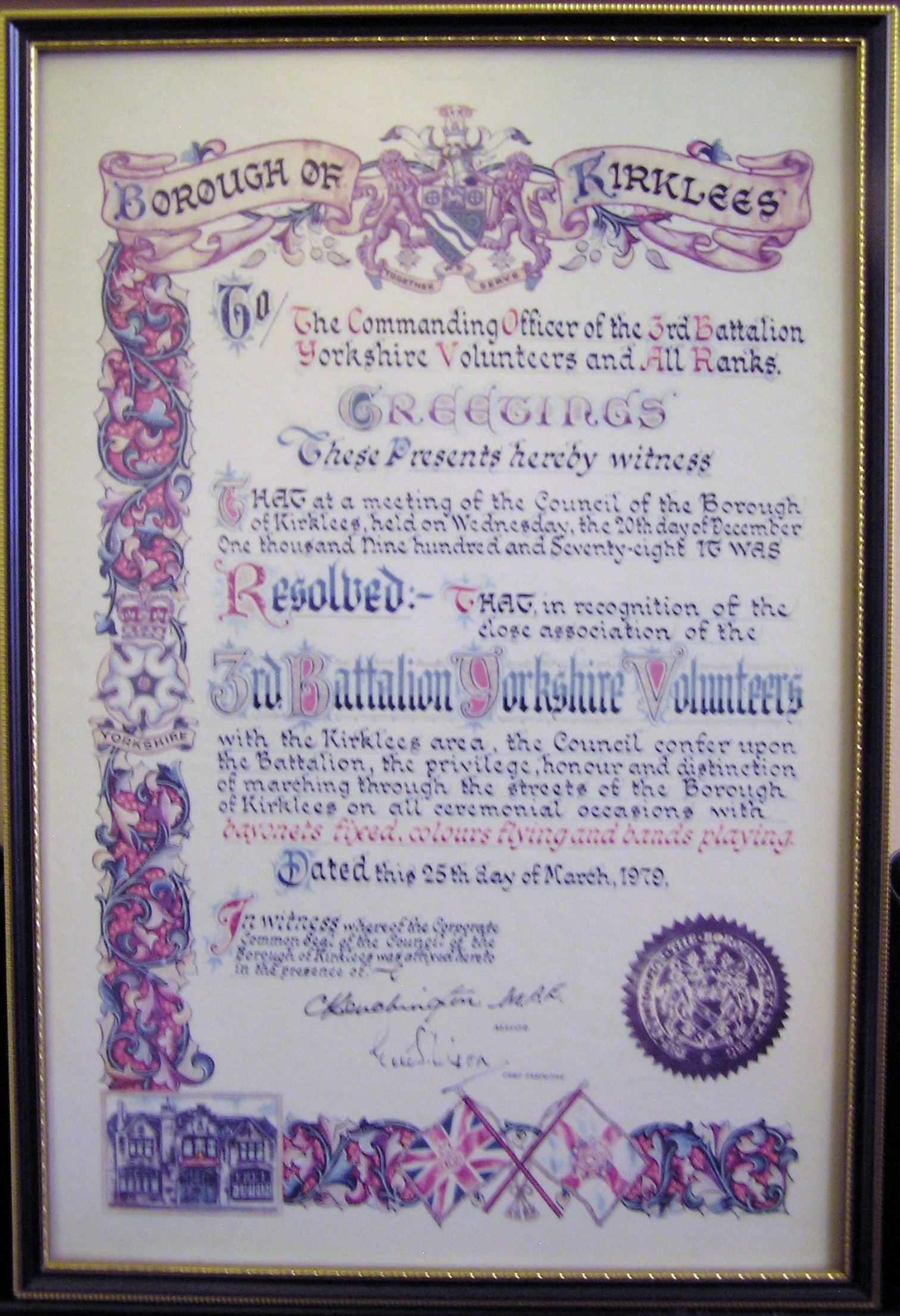
 Yorkshire Volunteers Freedom Scroll
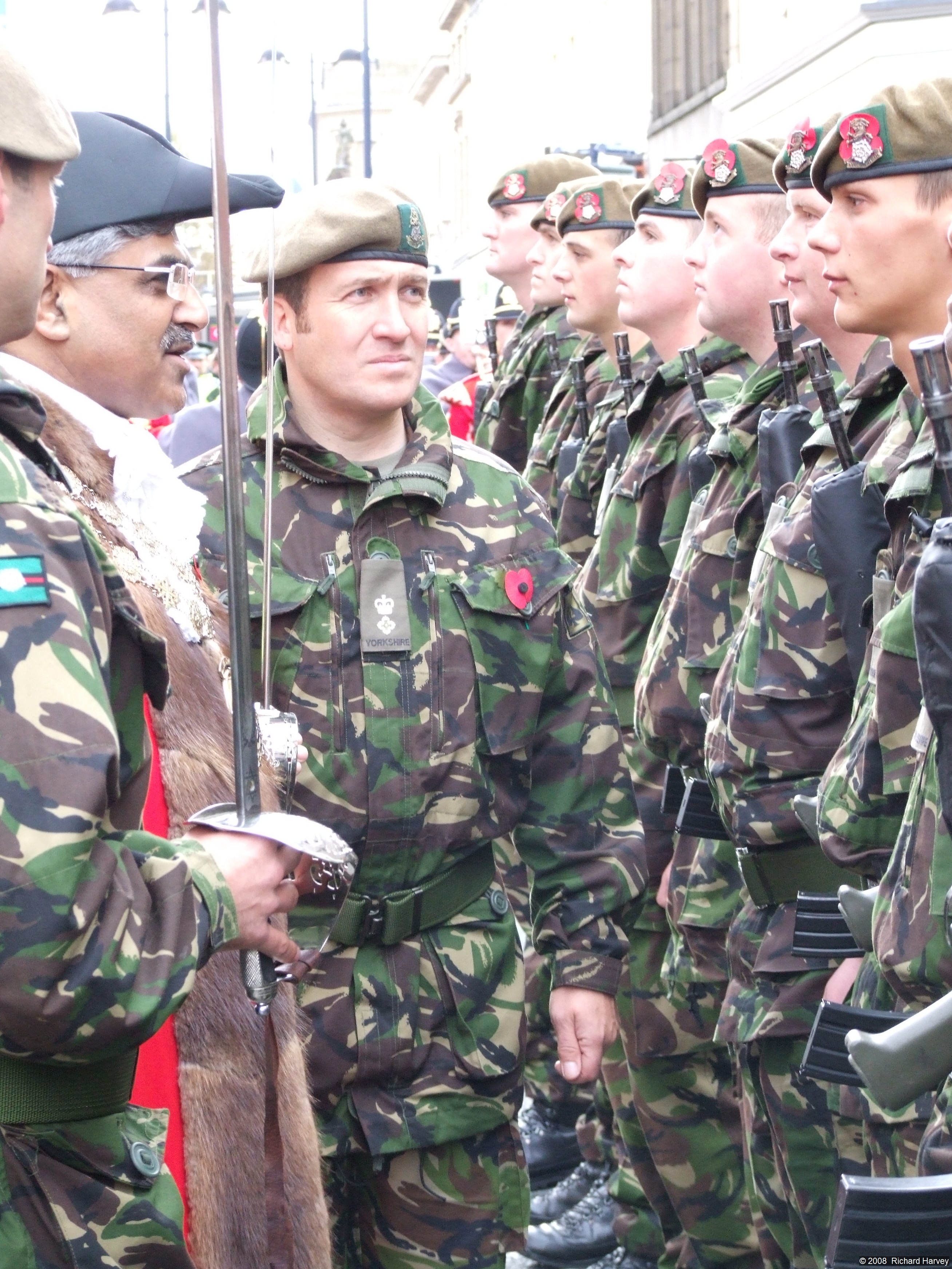
 Kirklees Mayor, Cllr Karam Hussain & Lt Col Andy Pullan Inspect Yorkshire Regiment Soldiers
- 3rd Battalion Yorkshire Volunteers - (25 March 1979)[50] On 25 March 1979 Kirklees Metropolitan Borough Council gave the Freedom of Kirklees to the 3rd Battalion of the Yorkshire Volunteers. The 3rd Battalion was at that time the Duke of Wellington's Regiment (West Riding) Territorial Army unit. However the freedom given by Kirklees to the 3rd battalion of the Yorkshire Volunteers did not permit any transfer to heirs or successors and effectively that freedom ceased when the battalion was amalgamated into the East and West Riding Regiment on 1 July 1999. The East and West Riding Regiment ceased to exist on 6 June 2006, having been merged into the Yorkshire Regiment as its 4th Battalion. The Yorkshire Regiment requested the freedom to march to be transferred to them. On 25 October 2008 Kirklees Council transferred the Freedom of Huddersfield to the Yorkshire Regiment at a freedom parade held by the 3rd Battalion, formerly the Duke of Wellington's Regiment (West Riding).
- Sir William Mallalieu MP (27 January 1980)[51]
- The Rt Hon Betty Boothroyd MP (20 November 1992)[51]
- Citizens of Besançon, France (7 October 2005)[51]
- The Yorkshire Regiment (25 October 2008) [52]
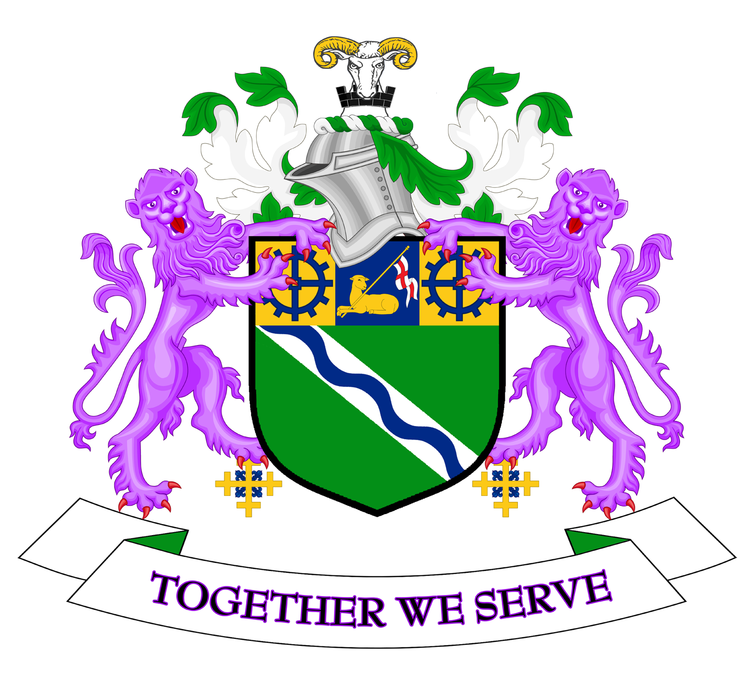
Coat of arms
Kirklees Borough Council was granted armorial bearings by the College of Arms by letters patent dated 24 June 1974. the blazon of the arms is as follows:
Vert on a bend Argent a bendlet wavy azure on a chief Or a pale between two cog-wheels azure on the pale a Paschal Lamb supporting a staff of the fourth flying therefrom a forked pennon argent charged with a cross gules; and for a Crest, On a wreath of the colours a ram's head affronty couped argent armed Or gorged with a mural crown sable masoned argent. Supporters: On either side a lion guardant purpure resting the inner hind leg on a cross crosslet Or embellished in each of the four angles with a fleur de lis azure. Badge or device: A roundel purpure charged with a Lacy Knot Or all within a circle of eleven roses argent barbed and seeded proper.[53]
The green colouring of the shield represents the fields, woods and moorland of the borough. The white stripe or bend represents the M62 motorway, while the blue wave upon it is for the many waterways of the area. On the chief or upper third of the shield is a paschal lamb, symbol of St John the Baptist. John was the patron saint of woolworkers, and the inclusion of the emblem represents the historic woollen industry. The cogwheels are for the modern engineering industries. The crest is a ram's head, found in the arms of the County Borough of Huddersfield and the Mirfield Urban District Council. The black mural crown stands for the district's status as a borough, recalling a city wall. The supporters are purple lions from the arms of the de Laci family, medieval lords of Huddersfield. For heraldic "difference" from other lion supporters a distinctive cross has been placed below their inner feet. This device, combining the symbols of Christ and the Virgin Mary, represents the priory from which the borough took its name.[53][54]
Parish and town councils
In five areas of the borough there is a second tier of local government: the civil parish. Parish or town councils have limited powers of a purely local character, such as owning or maintaining allotments, burial grounds, footpaths and war memorials. Four of the parishes were formed as successor parishes to urban districts abolished in 1974.[55] The fifth was formed in 1988.[56] The five town or parish councils are:
Council Area covered Number of councillors Parish Wards Formed Denby Dale Parish Council Denby Dale, Upper and Lower Cumberworth, Upper and Lower Denby, Birdsedge and High Flatts, Scissett, Skelmanthorpe and the hamlet of Kitchenroyd, Emley and Emley Moor and Clayton West[55] 17[57] Clayton West, Denby & Cumberworth, Emley, Skelmanthorpe[57] Successor to Denby Dale UDC 1973[58] Holme Valley Parish Council Holmfirth and Honley, Brockholes, Cinderhills, Hade Edge, Hepworth, Hinchliffe Mill, Holmbridge, Holme, Jackson Bridge, Netherthong, New Mill, Scholes, Thongsbridge, Upperthong, Wooldale[55] 23[59] Brockholes, Fulstone, Hepworth, Holmfirth Central, Honley Central and East, Honley South, Honley West, Netherthong, Scholes, Upper Holme Valley, Upperthong, Wooldale[59] Successor to Holmfirth UDC 1973,[58] renamed Holme Valley 1975. Kirkburton Parish Council Farnley Tyas, Flockton, Grange Moor, Highburton, Kirkburton, Kirkheaton, Lepton, Shelley, Shepley and Thurston[55] 25[60][61] Flockton, Kirkburton, Kirkheaton, Lepton, Lepton & Whitley Upper, Shelley, Shepley, Thurstonland/Farnley Tyas[60][61] Successor to Kirkburton UDC 1973[58] Meltham Town Council Crosland Edge, Meltham, Helme, Wilshaw[55] 12[62] None[62] Successor to Meltham UDC 1973[58] Mirfield Town Council Battyeford, Mirfield, Northorpe, Lower Hopton and Upper Hopton[55] 16[56] Battyeford, Crossley, Eastthorpe, Hopton, Northorpe[56] Formed 1988[56] The remainder of the borough is unparished, with the borough council exercising parish powers.
Parliamentary representation
1997 to date
Since 1997 Kirklees has been divided into five constituencies: four being entirely within the borough, while two wards are included in the Wakefield constituency.
The boundaries of two of the Colne Valley and Huddersfield constituencies were virtually unchanged from those defined in 1983. Denby Dale and Kirkburton wards were transferred from Dewsbury to Wakefield, with the former constituency receiving Heckmondwike ward from Batley and Spen.
The constituencies were first used at the 1997 general election, when the Labour Party came to power in a landslide, gaining all the seats in the borough. The party held the seats at the subsequent elections of 2001 and 2005.[63]
Constituency Wards Member of parliament Party Majority Batley and Spen Borough Constituency The following wards continued to formulate the Batley seat from 1997-2005:
Batley East, Batley West, Birstall and Birkenshaw, Cleckheaton and Spen.At the 2010 general elections the boundary commission moved Heckmondwike from
Dewsbury into the Batley seat and moved Hanging Heaton from the Batley seat
into the Dewsbury seat[63]Mike Wood Labour Party 2010: 4,406 (over Conservatives) 2005: 5,788 (over Conservatives) 2001: 5,064 (over Conservatives)[64] 1997: 6,141 (over Conservatives)[64] Colne Valley County Constituency Colne Valley West, Crosland Moor,
Golcar, Holme Valley North,
Holme Valley South and Lindley.[63]Jason McCartney Conservative Party 2010: 4,837 (over Liberal Democrats) Kali Mountford Labour Party 2005: 1,501 (over Conservatives) 2001: 4,639 (over Conservatives)[65] 1997: 4,840 (over Conservatives)[65] Dewsbury County Constituency The following wards continued to formulate the Dewsbury seat from 1997-2005:
Dewsbury East, Dewsbury West, Heckmondwike, Mirfield and Thornhill.
At the 2010 general elections the boundary commission moved Heckmondwike from
Dewsbury into the Batley seat and moved Hanging Heaton from the Batley seat
into the Dewsbury seat. In addition, it moved the two wards of Denby Dale and
Kirkburton from Wakefield into Dewsbury[63]Simon Reevell Conservative Party 2010: 1,526 (over Labour) Shahid Malik Labour Party 2005: 4,615 (over Conservatives) Ann Taylor 2001: 8,323 (over Conservatives)[66] 1997: 4,840 (over Conservatives)[66] Huddersfield Borough Constituency Almondbury, Birkby,
Dalton, Deighton,
Newsome and Paddock.[63]Barry Sheerman Labour Co-op 2010: 4,472 (over Conservatives) 2005: 8,351 (over Conservatives) 2001: 10,046 (over Conservatives)[67] 1997: 15,848 (over Conservatives)[67] Wakefield County Constituency At the 2010 general elections the boundary commission moved Denby Dale
and Kirkburton wards out of Wakefield seat and into the Dewsbury seat
Remainder of constituency composed
of wards of the
Metropolitan Borough of Wakefield[63]Mary Creagh Labour Party 2010: 1,613 (over Conservatives) 2005: 5,154 (over Conservatives) David Hinchliffe 2001: 7,954 (over Conservatives)[68] 1997: 14,604 (over Conservatives)[68] 1983 to 1997
The 1983 general election was the first at which constituencies based on the administrative areas created in 1974 were used. Kirklees was divided into four constituencies.[69] The Conservative Party polled well in the 1983 election, and took two of the borough's constituencies. Labour held Huddersfield, while the Liberals, running in an alliance with the Social Democrats, held Colne Valley. In the following election in 1987 the Labour vote increased slightly, and they gained Dewsbury from the Conservatives. At the same time the Alliance vote fell, and the Conservatives took Colne Valley. The four MPs elected in 1992 were all returned in 1997.
Constituency Wards Member of parliament Party Majority Batley and Spen Borough Constituency Batley East, Batley West,
Birstall and Birkenshaw,
Cleckheaton, Heckmondwike and Spen[69]Elizabeth Peacock Conservative Party 1992: 1,408 (over Labour)[70] 1987: 1,362 (over Labour)[71] 1983: 870 (over Labour)[72] Colne Valley County Constituency Colne Valley West, Crosland Moor,
Golcar, Holme Valley North,
Holme Valley South and Lindley.[69]Graham Riddick Conservative Party 1992: 7,225 (over Labour)[73] 1987: 1,677 (over Liberal / Alliance)[74] Richard Wainwright Liberal / Alliance 1983: 3,146 (over Conservatives)[75] Dewsbury County Constituency Denby Dale, Dewsbury East, Dewsbury West,
Kirkburton, Mirfield and Thornhill.[69]
Ann Taylor Labour Party 1992: 634 (over Conservatives))[76] 1987: 445 (over Conservatives)[77] John Whitfield Conservative Party 1983: 2,068 (over Labour)[78] Huddersfield Borough Constituency Almondbury, Birkby,
Dalton, Deighton,
Newsome and Paddock.[69]Barry Sheerman Labour Party 1992: 7,258 (over Conservatives)[79] 1987: 7,278 (over Conservatives)[80] 1983: 3,955 (over Conservatives)[79] 1974 to 1983
Parliamentary constituencies in England and Wales continued to be defined in terms of the boroughs and districts abolished in 1974 until a general redistribution of seats in 1983. Accordingly, Kirklees was divided between seven constituencies, which had first been used in the 1950 general election.[81]
Constituency Former administrative areas Member of parliament Party Majority Batley and Morley Borough Constituency Municipal Borough of Batley
Also included the former Municipal Borough of Morley
in the City of Leeds.Kenneth Woolmer Labour Party 1979: 5,352 (over Conservatives)[82] A D D Broughton October 1974: 8,248 (over Conservatives)[83] February 1974: 7,091 (over Conservatives)[84] Brighouse and Spenborough Borough Constituency Municipal Borough of Spenborough
Also included the former Municipal Borough of Brighouse
in the Metropolitan Borough of Calderdale.Gary Waller Conservative Party 1979: 1,734 (over Labour)[85] Colin Jackson Labour Party October 1974: 2,177 (over Conservatives)[86] February 1974: 1,546 (over Conservatives)[87] Colne Valley County Constituency Colne Valley Urban District, Holmfirth Urban District,
Kirkburton Urban District, Meltham Urban District
Also included the former Saddleworth Urban District
in the Metropolitan Borough of Oldham.Richard Wainwright Liberal Party 1979: 2,352 (over Labour)[88] October 1974: 1,666 (over Labour)[89] February 1974: 719 (over Labour)[90] Dewsbury Borough Constituency Municipal Borough of Dewsbury, Heckmondwike Urban District, Mirfield Urban District
Also included the former Municipal Borough of Ossett
in the City of Wakefield.David Ginsburg Labour Party
(Defected to the
Social Democratic Party in
1981 when he seemed unlikely
to be reselected
as Labour candidate for the next election.)[91]1979: 4,381 (over Conservatives)[92] October 1974: 6,901 (over Conservatives)[93] February 1974: 5,412 (over Conservatives)[94] Huddersfield East Borough Constituency Seven wards of the County Borough of Huddersfield:
Almondbury, Dalton, Deighton,
Fartown, Newsome, North Central,
South CentralBarry Sheerman Labour Party 1979: 3,095 (over Conservatives)[95] Joseph Mallalieu October 1974: 8,414 (over Conservatives)[96] February 1974: 7,304 (over Conservatives)[97] Huddersfield West Borough Constituency Eight wards of the County Borough of Huddersfield:
Birkby, Crosland Moor, Lindley,
Lockwood, Longwood, Marsh,
Milnsbridge, PaddockGeoffrey Dickens Conservative Party 1979: 1,508 (over Labour)[95] Kenneth Lomas Labour Party October 1974: 1,364 (over Conservatives)[96] February 1974: 630 (over Conservatives)[97] Penistone County Constituency Denby Dale Urban District
Remainder of constituency consisted
of former urban and rural districts
in the Metropolitan Borough of Barnsley and
the City of SheffieldAllen McKay Labour Party 1979: 9,701 (over Conservatives)[98] 1978 by-election: 5,371 (over Conservatives) John Mendelson October 1974: 1,364 (over Conservatives)[99] February 1974: 630 (over Conservatives)[100] Geography
Most of Kirklees consists of old mill towns although there are a few country villages, such as Denby Dale and Emley. The combination of the two county boroughs (which only happened in three other metropolitan districts: Wirral, Sefton and Sandwell) resulted in a borough with no clear centre. Graham Riddick, MP for Colne Valley, campaigned in the early 1990s for it to be split into two.[101][102] A similar ambition was mentioned by Elizabeth Peacock, MP for Batley and Spen in 1991.[103] The boundaries of metropolitan boroughs were outside the remit of the Banham Commission appointed to review local government structures in 1992 or its successors, and only minor boundary changes were made with neighbouring districts in 1994.[104][105][106]
The district includes areas of three postal codes. Birkenshaw, Cleckheaton and Gomersal lie within the BD Bradford area. The Huddersfield HD postcode also includes the rural south area of the district, while Batley, Dewsbury, Heckmondwike and Mirfield lie within the Wakefield WF postcode. Similarly, the telephone dialling codes are split, with Kirklees residents being split between 01484 Huddersfield, 01274 Bradford and 01924 Wakefield. A small number of residents fall within 01422 Halifax (Birchencliffe village) and 0113 (part of Birkenshaw).
Demography
Religion
The stated religion of the population of Kirklees, as recorded at the 2001 census of population was as follows:[107]
- Christian 261,128 (67.2%)
- No religion 54,445 (14%)
- Muslim 39,312 (10.1%)
- Religion not stated 28,394 (7.3%)
- Sikh 2,726 (0.7%)
- Hindu 1,222 (0.3%)
- Other Religions 772 (0.2%)
- Buddhist 397 (0.1%)
- Jewish 171 (0.0%)
Notable features
One attraction in Kirklees is Kirklees Light Railway. The border of Kirklees borough with Derbyshire (High Peak district) runs across the summit of the significant hill named Black Hill.
The last remaining colliery in West Yorkshire is at Scissett; the mine was so small that it was never nationalised and has always been in private hands.
Dewsbury and Batley have been made into a special E.U. transformation area to address their problems of deprivation.
See also
- List of people from Kirklees
References
- ^ "Resident Population Estimates by Ethnic Group (Percentages); Mid-2005 Population Estimates". National Statistics Online. Office for National Statistics. http://www.neighbourhood.statistics.gov.uk/dissemination/LeadTableView.do?a=3&b=276809&c=kirklees&d=13&e=13&g=380747&i=1001x1003x1004&m=0&r=1&s=1206614147489&enc=1&dsFamilyId=1812. Retrieved 2008-04-17.
- ^ a b c O'Leary, Patrick (8 August 1974). "Kirklees: Robin Hood brings the communities together". The Times: p. 12.
- ^ "In the footsteps of Robin Hood". History. Channel 4. http://www.channel4.com/history/microsites/H/history/n-s/robin07.html. Retrieved 2009-02-14.
- ^ Ossett Town Hall, Ossett Historical Society, 2008, page 104
- ^ "The Borough of Kirklees (Electoral Changes) Order 2003". Office of Public Sector Information. 2003. http://www.opsi.gov.uk/si/si2003/20033091.htm. Retrieved 2009-02-15.
- ^ a b c "Local elections 2007 - Election summary". Kirklees Council. http://www2.kirklees.gov.uk/you-kmc/kmc-howcouncilworks/votingandelections/election04/FullSummary2007.asp. Retrieved 2009-02-15.
- ^ "Results for the 01 May 2008 District Council Election". Kirklees Council. http://www2.kirklees.gov.uk/you-kmc/kmc-howcouncilworks/election/result11.shtml. Retrieved 2009-02-15.
- ^ Newsome ward - unemployment, employment, welfare benefits
- ^ "BNP 'shocked' after councillor quits party". Huddersfield Examiner: p. 7. 14 July 2008.
- ^ a b "Labour delight at poll victory". Huddersfield Examiner: p. 15. 18 October 2008.
- ^ "A Clear Mesage". Huddersfield Examiner: p. 1. 6 May 2006.
- ^ "Kirklees Council election results - May 5". http://www2.kirklees.gov.uk/news/onlinenews/newsdesk/fullstory.aspx?id=3409.
- ^ "Kirklees council". Election 2010 (BBC). 7 May 2010. http://news.bbc.co.uk/2/shared/election2010/council/html/3710.stm. Retrieved 14 June 2010.
- ^ "Results for the 06 May 2010 District Council Election". Kirklees Council. http://www2.kirklees.gov.uk/you-kmc/kmc-howcouncilworks/election/result24.shtml. Retrieved 14 June 2010.
- ^ "Leader of Kirklees Council". Kirklees Council. January 2009. http://www.kirklees.gov.uk/you-kmc/Leader/leadermain.shtml. Retrieved 2009-02-15.
- ^ Gibson, Barry (23 January 2009). "Kirklees Council 'ruled by partnership' say new leaders". Huddersfield Daily Examiner. http://www.examiner.co.uk/news/local-west-yorkshire-news/2009/01/23/kirklees-council-ruled-by-partnership-say-new-leaders-86081-22758488/2/. Retrieved 15 February 2009.
- ^ "Results for the 16 Oct 2008 District Council Dewsbury East By-election". Voting and elections. Kirklees Council. October 2008. http://www2.kirklees.gov.uk/you-kmc/kmc-howcouncilworks/election/result23.shtml. Retrieved 2009-02-15.
- ^ "Results for the 01 May 2008 District Council Election". Kirklees Council. May 2008. http://www2.kirklees.gov.uk/you-kmc/kmc-howcouncilworks/election/result11.shtm. Retrieved 2009-02-15.[dead link]
- ^ a b "Local elections 2004 - Election summary". Voting and elections. Kirklees Council. April 2007. http://www.kirklees.gov.uk/you-kmc/kmc-howcouncilworks/votingandelections/election04/FullSummary2004.asp. Retrieved 2009-02-15.
- ^ "Elections 2004: Results at a glance". The Guardian: p. 10. 12 June 2004.
- ^ a b "How the councils fared". The Times: p. 2. 8 May 1982.
- ^ "Three major parties find cause for satisfaction in local election results despite low poll". The Times. 14 May 1973.
- ^ "Tories capture 199 seats in 'big cities' poll triumph, May Day blow to Labour as the Tories make many gains in district council elections". The Times. 2 May 1975.
- ^ "Tories seize cities but fail to achieve expected landslide". The Times. 7 May 1976.
- ^ "Power shift in only eight of 80 councils outside London". The Times: p. 3. 6 May 1978.
- ^ Whitaker's Almanac, 1980
- ^ "Labour makes gains throughout Britain in local government elections". The Times: p. 4. 2 May 1980.
- ^ "Conservative candidates hold ground as Alliance bandwagon falters". The Times: p. 2. 7 May 1982.
- ^ "How votes were cast in local government elections". The Times: p. 4. 7 May 1983.
- ^ "Labour captures Birmingham, Tories hold Birmingham". The Times: p. 4. 6 May 1983.
- ^ "How the main parties fared in Britain's local elections". The Times. 10 May 1986.
- ^ "Results in Thiursday's local elections". The Times. 9 May 1987.
- ^ "The gains and losses: Council election results in full". The Times. 7 May 1988.
- ^ "Local election results". The Times. 5 May 1990.
- ^ "Local election results 1992". The Times: p. 6. 9 May 1992.
- ^ "Local elections: Tories lose 18 councils in worst poll performance". The Guardian: p. 4. 7 May 1994.
- ^ "Complete list of results from Thursday's local elections". The Times: p. 10. 6 May 1995.
- ^ "Complete list of results". The Times: p. 8. 4 May 1996.
- ^ "Local election results". The Times: p. 46. 9 May 1998.
- ^ "How Britain voted: Council election results". The Independent: p. 12. 8 May 1999.
- ^ "Election results: Local councils". The Times: p. 10. 6 May 2000.
- ^ "Election results: Local councils". The Times: p. 16. 4 May 2002.
- ^ "Election results". Financial Times: p. 8. 3 May 2003.
- ^ a b "Article 10 - Area Committees". Constitution. Kirklees Council. November 2008. http://www.kirklees.gov.uk/you-kmc/constitution/articles/art10.pdf. Retrieved 2009-02-14.
- ^ "Locality profiles". Kirklees Council. October 2008. http://www.kirklees.gov.uk/community/statistics/servicedelivery/profiles.shtml. Retrieved 2009-02-14.
- ^ Local government in England and Wales: A Guide to the New System. London: HMSO. 1974. p. 25. ISBN 0117508470.
- ^ "Former Mayors". Kirklees Council. August 2008. http://www2.kirklees.gov.uk/you-kmc/mayor/former/formermenu.shtml. Retrieved 2009-02-15.
- ^ "The Mayor's Role". Kirklees Council. May 2006. http://www.kirklees.gov.uk/you-kmc/mayor/mayorsrole.shtml. Retrieved 2009-02-15.
- ^ "Huddersfield people undecided on city status bid". Huddersfield Examiner. 9 August 2001. http://www.holdthefrontpage.co.uk/news/2001/08aug/010809poll.shtml. Retrieved 2009-02-14.
- ^ "The Dukes and The West Riding". Regimental History. The Duke of Wellington's Regiment (West Riding)Regimental Association. 2009. http://www.dwr.org.uk/dwr.php?id=132. Retrieved 2009-02-14.
- ^ a b c "Freedom of Kirklees ...for a French town!". Huddersfield Examiner. 1 April 2005. http://www.examiner.co.uk/news/local-west-yorkshire-news/tm_objectid=15357953&method=full&siteid=50060&headline=freedom-of-kirklees----for-a-french-town--name_page.html. Retrieved 14 February 2009.
- ^ Hirst, Andrew (16 October 2008). "Special Huddersfield parade to honour Yorkshire Regiment". Huddersfield Examiner. http://www.examiner.co.uk/news/local-west-yorkshire-news/2008/10/16/special-huddersfield-parade-to-honour-yorkshire-regiment-86081-22044322/. Retrieved 14 February 2009.
- ^ a b "Kirklees Metropolitan Borough Council". Civic Heraldry of England and Wales. http://www.civicheraldry.co.uk/w_yorks.html#kirklees%20mbc. Retrieved 2009-02-14.
- ^ Kirklees Borough Guide, c.1974
- ^ a b c d e f "Parish and Town Councils". Kirklees Council. January 2006. http://www.kirklees.gov.uk/you-kmc/parishcouncil/parishmenu.shtml. Retrieved 2009-02-16.
- ^ a b c d "About the Council". Mirfield Town Council. 9 February 2009. http://www.mirfieldtowncouncil.gov.uk/council/15. Retrieved 2009-02-16.
- ^ a b "The Councillors". Denby Dale Parish Council. 2007. http://www.denbydale.com/content/councillors. Retrieved 2009-02-16.
- ^ a b c d The Local Government (Successor Parishes) (No. 2) Order 1973 (S.I. 1973/1939)
- ^ a b "Members of the Council". Holme Valley Parish Council. http://www.holmevalleyparishcouncil.gov.uk/members/memberspage.htm. Retrieved 2009-02-16.
- ^ a b "Kirkburton Parish Council". Kirklees Council. July 2007. http://www.kirklees.gov.uk/you-kmc/parishcouncil/kirkburton.shtml. Retrieved 2009-02-16.
- ^ a b "Parish Councillors' Contact Details". Kirkburton Parish Council. 2007. http://www.mapfm.co.uk/kbpc/contacts.html. Retrieved 2009-02-16.
- ^ a b "Your members of the council". Meltham Town Council. 2008. http://www.melthamtowncouncil.gov.uk/homedir/members.htm. Retrieved 2009-02-16.
- ^ a b c d e f "The Parliamentary Constituencies (England) Order 1995 (S.I. 1995/1626)". Office of Public Sector Information. 1995. http://www.opsi.gov.uk/si/si1995/Uksi_19951626_en_2.htm. Retrieved 2009-02-16.
- ^ a b "Batley & Spen". Political Science Resources. University of Keele. http://www.psr.keele.ac.uk/area/uk/constit/080.htm. Retrieved 2009-02-15.
- ^ a b "Colne Valley". Political Science Resources. University of Keele. http://www.psr.keele.ac.uk/area/uk/constit/521.htm. Retrieved 2009-02-15.
- ^ a b "Dewsbury". Political Science Resources. University of Keele. http://www.psr.keele.ac.uk/area/uk/constit/522.htm. Retrieved 2009-02-15.
- ^ a b "Huddersfield". Political Science Resources. University of Keele. http://www.psr.keele.ac.uk/area/uk/constit/154.htm. Retrieved 2009-02-15.
- ^ a b "Wakefield". Political Science Resources. University of Keele. http://www.psr.keele.ac.uk/area/uk/constit/529.htm. Retrieved 2009-02-15.
- ^ a b c d e The Parliamentary Constituencies (England) Order 1983 (S.I. 1983/417)
- ^ "United Kingdom General Election Results 1992". Political Science Resources. University of Keele. http://www.psr.keele.ac.uk/area/uk/ge92/i02.htm. Retrieved 2009-02-16.
- ^ "United Kingdom General Election Results 1987". Political Science Resources. University of Keele. http://www.psr.keele.ac.uk/area/uk/ge87/i02.htm. Retrieved 2009-02-16.
- ^ "United Kingdom General Election Results 1983". Political Science Resources. University of Keele. http://www.psr.keele.ac.uk/area/uk/ge83/i02.htm. Retrieved 2009-02-16.
- ^ "United Kingdom General Election Results 1992". Political Science Resources. University of Keele. http://www.psr.keele.ac.uk/area/uk/ge92/i06.htm. Retrieved 2009-02-16.
- ^ "United Kingdom General Election Results 1987". Political Science Resources. University of Keele. http://www.psr.keele.ac.uk/area/uk/ge87/i06.htm. Retrieved 2009-02-16.
- ^ "United Kingdom General Election Results 1983". Political Science Resources. University of Keele. http://www.psr.keele.ac.uk/area/uk/ge83/i06.htm. Retrieved 2009-02-16.
- ^ "United Kingdom General Election Results 1992". Political Science Resources. University of Keele. http://www.psr.keele.ac.uk/area/uk/ge92/i07.htm. Retrieved 2009-02-16.
- ^ "United Kingdom General Election Results 1987". Political Science Resources. University of Keele. http://www.psr.keele.ac.uk/area/uk/ge87/i07.htm. Retrieved 2009-02-16.
- ^ "United Kingdom General Election Results 1983". Political Science Resources. University of Keele. http://www.psr.keele.ac.uk/area/uk/ge83/i07.htm. Retrieved 2009-02-16.
- ^ a b "United Kingdom General Election Results 1983". Political Science Resources. University of Keele. http://www.psr.keele.ac.uk/area/uk/ge83/i11.htm. Retrieved 2009-02-16.
- ^ "United Kingdom General Election Results 1987". Political Science Resources. University of Keele. http://www.psr.keele.ac.uk/area/uk/ge87/i11.htm. Retrieved 2009-02-16.
- ^ Representation of the People Act 1948, (c.65), Schedule I
- ^ "United Kingdom General Election Results 1979". Political Science Resources. University of Keele. http://www.psr.keele.ac.uk/area/uk/ge79/i02.htm. Retrieved 2009-02-16.
- ^ "United Kingdom General Election Results October 1974". Political Science Resources. University of Keele. http://www.psr.keele.ac.uk/area/uk/ge74b/i02.htm. Retrieved 2009-02-16.
- ^ "United Kingdom General Election Results February 1974". Political Science Resources. University of Keele. http://www.psr.keele.ac.uk/area/uk/ge74a/i02.htm. Retrieved 2009-02-16.
- ^ "United Kingdom General Election Results 1979". Political Science Resources. University of Keele. http://www.psr.keele.ac.uk/area/uk/ge79/i04.htm. Retrieved 2009-02-16.
- ^ "United Kingdom General Election Results October 1974". Political Science Resources. University of Keele. http://www.psr.keele.ac.uk/area/uk/ge74b/i04.htm. Retrieved 2009-02-16.
- ^ "United Kingdom General Election Results February 1974". Political Science Resources. University of Keele. http://www.psr.keele.ac.uk/area/uk/ge74a/i04.htm. Retrieved 2009-02-16.
- ^ "United Kingdom General Election Results 1979". Political Science Resources. University of Keele. http://www.psr.keele.ac.uk/area/uk/ge79/i06.htm. Retrieved 2009-02-16.
- ^ "United Kingdom General Election Results October 1974". Political Science Resources. University of Keele. http://www.psr.keele.ac.uk/area/uk/ge74b/i06.htm. Retrieved 2009-02-16.
- ^ "United Kingdom General Election Results February 1974". Political Science Resources. University of Keele. http://www.psr.keele.ac.uk/area/uk/ge74a/i06.htm. Retrieved 2009-02-16.
- ^ Crewe, Ivor; King, Anthony (1995). SDP: The Birth, Life and Death of the Social Democratic Party. Oxford: Oxford University Press. p. 109. ISBN 0198280505.
- ^ "United Kingdom General Election Results 1979". Political Science Resources. University of Keele. http://www.psr.keele.ac.uk/area/uk/ge79/i07.htm. Retrieved 2009-02-16.
- ^ "United Kingdom General Election Results October 1974". Political Science Resources. University of Keele. http://www.psr.keele.ac.uk/area/uk/ge74b/i07.htm. Retrieved 2009-02-16.
- ^ "United Kingdom General Election Results February 1974". Political Science Resources. University of Keele. http://www.psr.keele.ac.uk/area/uk/ge74a/i07.htm. Retrieved 2009-02-16.
- ^ a b "United Kingdom General Election Results 1979". Political Science Resources. University of Keele. http://www.psr.keele.ac.uk/area/uk/ge79/i11.htm. Retrieved 2009-02-16.
- ^ a b "United Kingdom General Election Results October 1974". Political Science Resources. University of Keele. http://www.psr.keele.ac.uk/area/uk/ge74b/i11.htm. Retrieved 2009-02-16.
- ^ a b "United Kingdom General Election Results February 1974". Political Science Resources. University of Keele. http://www.psr.keele.ac.uk/area/uk/ge74a/i11.htm. Retrieved 2009-02-16.
- ^ "United Kingdom General Election Results 1979". Political Science Resources. University of Keele. http://www.psr.keele.ac.uk/area/uk/ge79/i16.htm. Retrieved 2009-02-16.
- ^ "United Kingdom General Election Results October 1974". Political Science Resources. University of Keele. http://www.psr.keele.ac.uk/area/uk/ge74b/i16.htm. Retrieved 2009-02-16.
- ^ "United Kingdom General Election Results February 1974". Political Science Resources. University of Keele. http://www.psr.keele.ac.uk/area/uk/ge74a/i16.htm. Retrieved 2009-02-16.
- ^ Parliamentary Debates, House of Commons, 3 March 1992, column 717.
- ^ Parliamentary Debates, House of Commons, 22 November 1993, column 277.
- ^ Parliamentary Debates, House of Collomons, 8 May 1991, column 711.
- ^ Parliamentary Debates, House of Commons, 4 December 1995, column 118.
- ^ "The Bradford, Kirklees and Leeds (City and Metropolitan Borough Boundaries) Order 1993". Office of Public Sector Information. 1993. http://www.opsi.gov.uk/si/si1993/Uksi_19930473_en_1.htm. Retrieved 2009-02-14.
- ^ "The Calderdale and Kirklees (Metropolitan Borough Boundaries) Order 1993". Office of Public Sector Information. 1993. http://www.opsi.gov.uk/SI/si1993/Uksi_19930850_en_1.htm. Retrieved 2009-02-14.
- ^ "Table KS07 religion". Statistics. Kirklees Council. http://www.kirklees.gov.uk/community/statistics/census2001/KS07ward04.pdf. Retrieved 2009-02-14.
External links
Ceremonial county of West Yorkshire Yorkshire Portal Metropolitan districts City of Bradford • City of Leeds • City of Wakefield • Metropolitan Borough of Calderdale • Metropolitan Borough of KirkleesMajor settlements Batley • Bingley • Bradford • Brighouse • Castleford • Cleckheaton • Denholme • Dewsbury • Elland • Farsley • Featherstone • Garforth • Guiseley • Halifax • Hebden Bridge • Hebden Royd • Heckmondwike • Hemsworth • Holmfirth • Horsforth • Huddersfield • Ilkley • Keighley • Knottingley • Leeds • Meltham • Mirfield • Morley • Mytholmroyd • Normanton • Ossett • Otley • Pontefract • Pudsey • Rothwell • Shipley • Silsden • South Elmsall • Sowerby Bridge • Todmorden • Wakefield • Warley Town • Wetherby • Yeadon
See also: List of civil parishes in West YorkshireTopics Parliamentary constituencies • West Yorkshire Joint Services • Monastic houses • Museums • Windmills Districts of Yorkshire and the Humber
Lincolnshire 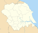
North Yorkshire Craven • Hambleton • Harrogate • Richmondshire • Ryedale • Scarborough • Selby • York
South Yorkshire West Yorkshire Bradford • Calderdale • East Riding of Yorkshire • Kingston upon Hull • Kirklees • Leeds • Wakefield
Metropolitan counties and metropolitan districts Greater Manchester 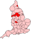
Merseyside South Yorkshire Tyne and Wear West Midlands West Yorkshire - Bradford
- Calderdale
- Kirklees
- Leeds
- Wakefield
Categories:- Local government districts in West Yorkshire
- Kirklees
- Local government in Kirklees
- Metropolitan boroughs
- Leeds City Region
- Local government districts of Yorkshire and the Humber


Wikimedia Foundation. 2010.