- Morley, West Yorkshire
-
Coordinates: 53°44′57″N 1°36′08″W / 53.749166°N 1.602263°W
Morley 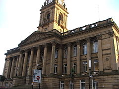
Morley Town Hall, a Grade I listed building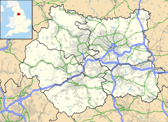
 Morley
Morley shown within West YorkshirePopulation 27,738 (2001) OS grid reference SE265275 Parish Morley Metropolitan borough City of Leeds Metropolitan county West Yorkshire Region Yorkshire and the Humber Country England Sovereign state United Kingdom Post town LEEDS Postcode district LS27 Dialling code 0113 Police West Yorkshire Fire West Yorkshire Ambulance Yorkshire EU Parliament Yorkshire and the Humber UK Parliament Morley and Outwood List of places: UK • England • Yorkshire Morley is a market town and civil parish within the metropolitan borough of the City of Leeds, in West Yorkshire, England. It lies approximately 5 miles (8 km) south-west of Leeds city centre. Together with Drighlington, Gildersome, Churwell, Tingley and East/West Ardsley, the town had a population of 47,579 in the 2001 census.[1] The civil parish had a population of 27,738.
The town is built on seven hills, like Rome: Scatcherd Hill, Dawson Hill, Daisy Hill, Chapel Hill, Hunger Hill, Troy Hill and Banks Hill.
Contents
History
Morley means "wood by a moor", from Old English mor "moor" + leah "wood, clearing". The name was recorded as Morelige in 1156. The -ley in the place name is typical of this section of West Yorkshire, alluding to a forest that was around in medieval times.
Morley, mentioned in the 1086 Domesday Book as Morelege, Morelei and Moreleia, is traditionally famous for its textile industry, notably the cloth "Shoddy", which was worn by both sides in the American Civil War.
Schoolgirl Sarah Harper was murdered by Robert Black in Morley in 1986, giving the town brief, national notoriety.
A fuller description of the history of the town is provided by the West Yorkshire Archaeology Service and Morley Community Archives - see external links below.
Governance
 Street map of Morley
Historically, Morley was the centre of one of two divisions of the wapentake of Agbrigg and Morley. Morley became a Municipal Borough in 1889 and under the Local Government Act 1972, was incorporated into the new City of Leeds Metropolitan District. Morley is represented on Leeds City Council by three wards (Morley North/Morley South and Ardsley/Robin Hood) each with three councillors. In May 2006 the electoral ward of Morley South voted for a councillor from the British National Party. The town had previously faced negative publicity following a controversial speech in 2004 by BNP leader Nick Griffin at Morley Town Hall where he allegedly aired racist views. Griffin was later unsuccessfully tried on suspicion of incitement to racial hatred following the speech.[2]
A town council was established in 2000, though it no longer governs Drighlington, Gildersome, Tingley and East and West Ardsley - areas formerly part of the municipal borough.
Following a review of parliamentary representation in West Yorkshire, the Morley and Rothwell parliamentary constituency, represented by Colin Challen (Labour) was abolished at the 2010 election and replaced by the new Morley and Outwood constituency.
The town's Municipal Coat of Arms features the symbolic principal industries of the Municipal Borough: Manufacturing of Woollen Cloth, Coal Mining and Quarrying.
Geography
Neighbouring areas 
Bradford Armley Leeds Drighlington 
Rothwell  Morley

Batley Dewsbury Wakefield Present
 Morley Indoor Market
 Queen Street
Morley Town Hall is sometimes used for music recordings. It has also been used in television shows Heartbeat and Emmerdale, owing to there being a disused magistrates court inside the building and a cobblestoned street to one side. It also hosts concerts by local schools and performances by the Morley Amateur Operatic Society, whose pantomimes have taken place at the Alexandra Hall for many years.
The town is perhaps most notable as the home of Orbit[3] - one of the U.K's foremost clubs, which hosted the world's biggest techno, trance and hard house DJs.[4] During the late nineties, the club became a mecca of Northern rave culture until its sudden closure in 2003.
There are three main supermarkets in Morley: a Morrisons in the town centre, an Asda to the south side of Morley, and a Sainsbury's at the White Rose Centre which lies on the outskirts of Morley, towards Beeston and Holbeck.
On 21 February 2010, a stone statue of Ernie Wise was erected outside Morley Post Office on Queen Street, and is now a tourist attraction in the town. The statue was officially unveiled by Ernie's widow, Doreen Wiseman.[5][6]
Transport
Morley railway station is half a mile (800 m) from the town centre on the Huddersfield Line. There is a service seven days a week to and from Leeds, but on Sundays, the service is less frequent.
Buses go to Leeds, Bradford, Wakefield and other West Yorkshire towns from bus stops in the vicinity of the Town Hall.
The M621 motorway runs to the west of the town and the M62 motorway to the south. Junctions 27 and 28 of the M62 are the ones closest to Morley.
Education
Three secondary schools serve pupils from Morley: The Morley Academy (formerly Morley High School and Morley Grammar), Bruntcliffe High School and Woodkirk High School (technically in West Ardsley but has a large proportion of students from Morley due to its catchment area). Leeds City College offers Further Education at numerous sites in the town. It also has an independent preparatory school; Queenswood School, which is based in a conservation area within the town centre.
Sport
Morley R.F.C. was founded in 1878 and was a member of the Northern Union. When the Northern Union clubs broke away from the RFU to form what is now rugby league, the Morley representatives missed the coach to Huddersfield as they were still in the pub. The club's heyday was in the 1970s where they won the Yorkshire Cup on five occasions. Some of this glory was recaptured in April 2005 when the club won the Powergen Intermediate Cup at Twickenham.
The town also has a cricket club (whose team plays in the Bradford League), along with a football club (Morley Town) and Rugby league club (Morley Borough).
Independent Wrestling company Dynamic Pro Wrestling (DPW) are based in Morley and put on monthly shows in Morley and around West Yorkshire.
Filmography
Morley is one of the main settings for the critically acclaimed and award winning David Peace's Red Riding Quartet novel and 2009 television series which explore West Yorkshire police corruption during the 1970s and 1980s.
Twin towns
 Siegen, Germany, since 1966.
Notable people
Natives of the town refer to themselves as Morleians. Notable Morleians include:
- British Prime Minister H. H. Asquith
- Sir Titus Salt, the creator of Saltaire
- Alice Scatcherd, 19th century pioneer for women's rights and philanthropist who donated Scatcherd Park to the town[7] [8]
- Helen Fielding, author of Bridget Jones' Diary
- Ben Kaye, Harlequins RL Player
- Nick Scruton, Bradford Bulls player
- Lee Smith, Leeds Rhinos player
- Jonathan Howson, Leeds United player
- Mark Crook, former professional footballer
Location grid
Churwell Birstall Middleton Morley, West Yorkshire Tingley References
- ^ "Census 2001". National Statistics. 2001. http://www.statistics.gov.uk/census2001/west_yorkshire_urban_area.asp.
- ^ "BNP boss aired 'race hell' views". BBC News. 2006-01-17. http://news.bbc.co.uk/1/hi/england/west_yorkshire/4620762.stm. Retrieved 2006-01-18.
- ^ http://www.theorbituary.com/showthread.php?t=313
- ^ http://www.theorbituary.com/showthread.php?t=3172
- ^ "Ernie Wise statue to be put in place this weekend". Morley Observer. 19 February 2010. http://www.morleyobserver.co.uk/news/Ernie-Wise-statue-to-be.6089263.jp.
- ^ http://www.morleyobserver.co.uk/news/Heart-to-heart-with-Ernie.6136195.jp
- ^ Urbex Scatcherd Family, St. Marys, Leeds
- ^ The women's suffrage movement: a reference guide, 1866-1928
External links
- Beyond Church at St Peter's Morley - Morley Parish Church
- Morley Town Council
- West Yorkshire Archaeology Service
- "The Ancient Parish of Batley". GENUKI. http://www.genuki.org.uk/big/eng/YKS/WRY/Batley/index.html. Retrieved 2007-10-29. Morley was in this parish
- Morley Community Archives
Ceremonial county of West Yorkshire Yorkshire Portal Metropolitan districts Major settlements Batley • Bingley • Bradford • Brighouse • Castleford • Cleckheaton • Denholme • Dewsbury • Elland • Farsley • Featherstone • Garforth • Guiseley • Halifax • Hebden Bridge • Hebden Royd • Heckmondwike • Hemsworth • Holmfirth • Horsforth • Huddersfield • Ilkley • Keighley • Knottingley • Leeds • Meltham • Mirfield • Morley • Mytholmroyd • Normanton • Ossett • Otley • Pontefract • Pudsey • Rothwell • Shipley • Silsden • South Elmsall • Sowerby Bridge • Todmorden • Wakefield • Warley Town • Wetherby • Yeadon
See also: List of civil parishes in West YorkshireTopics Parliamentary constituencies • West Yorkshire Joint Services • Monastic houses • Museums • WindmillsCategories:- Places in Leeds
- Market towns in West Yorkshire
- Heavy Woollen District
- Civil parishes in West Yorkshire
- Towns in West Yorkshire


Wikimedia Foundation. 2010.