- Çoruh River
-
Çoruh, Ch'orokhi, Acampsis 
Origin Mescid Mountains Mouth Black Sea Basin countries Turkey, Georgia Length 438 km[1] Avg. discharge 278 m3/s Basin area 22,100 km2 The Çoruh River or Ch'orokhi River (Georgian: ჭოროხი ch'orokhi, Turkish: Çoruh, Armenian: Ճորոխ, Tchorokh, Greek: Άκαμψις, Akampsis) rises in the Mescit Mountains in north-eastern Turkey, flows through the cities of Bayburt, Ispir, Yusufeli, and Artvin, along the Kelkit-Çoruh Fault, before flowing into Georgia, where it reaches the Black Sea just south of Batumi and a few kilometers north of the Turkish-Georgian border.
In Arrian's Periplus Ponti Euxini, it is called the Άκαμψις Acampsis; Pliny may have confused it with the Bathys.[2] In English, it was formerly known as the Boas, the Churuk, or the Chorokh.[3][4]
Contents
Biodiversity
The Çoruh valley lies within the Caucasus ecological zone, which is considered by the World Wild Fund for Nature and by Conservation International as a biodiversity hotspot.[5][6] The Çoruh Valley is recognised by Turkish conservation organisations as an important plant area,[7] an important bird area,[8] a key biodiversity area[9] and has been nominated as a high priority area for protection. This valley is rich in plants and contains 104 nationally threatened plant species of which 67 are endemic to Turkey.[7]
Recreation
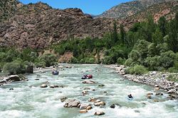
The Çoruh has been called "an eco-tourism gem" and "Turkey's last remaining wild river", and is being promoted for whitewater kayaking by the Eastern Anatolia Tourism Development Project.[10] It attracts kayakers and rafters from all over the world and was the site of the 2005 Coruh Extreme kayak competition.[11]

Dams
A total of 13 hydro-electric dams are planned as part of the Çoruh River Development Plan[12] but a total of 27 are proposed for the Çoruh River Catchment. Under the Çoruh Development Plan, 2 dams have been completed (Murtli Dam and Tortum Dam), another is under construction (Deriner Dam) and Yusufeli Dam, just upstream is in its final planning phase.
Dam Phase Tortum Dam Operational Muratli Dam Operational Borçka Dam Operational Deriner Dam Under construction Artvin Dam Planned Yusufeli Dam Planned Olur Dam Planned Arkun Dam Planned Aksu Dam Under construction Güllübağ Dam Planned Ispir Dam Dam Planned Laleli Dam Planned References
- ^ UN Economic Commission for Europe, Our waters: joining hands across borders : first assessment of transboundary, p. 150
- ^ William Smith, Dictionary of Greek and Roman geography, 1:216 (1854).
- ^ Encyclopedia Britannica, Eleventh Edition 2:757d
- ^ W. Rickmer Rickmers, "Lazistan and Ajaristan", The Geographical Journal 84:6 (Dec., 1934), p. 466. at JSTOR
- ^ WWF Global 200 Regions
- ^ Conservation International Biodiversity Hotspots
- ^ a b Ozhatay N, Byfield A & Atay S 2005, 122 Important Plant Areas of Turkey, for WWF Turkey, Istanbul, Turkey.
- ^ Magnin G & Yarar M 1989, Important Bird Area in Turkey, Dogal Hayati Koruma Dernegi, Turkey.
- ^ Eken G, Bozdogan M, I˙sfendiyaroglu S, Kılıç DT & Lise Y, (editörler) 2006, Key biodiversity areas in Turkey, Doga Dernegi, Ankara, Turkey.
- ^ United Nations Development Programme: Europe & CIS, "Eastern Turkey Becomes Tourist Destination" [1]
- ^ Coruh Extreme Race
- ^ ENCON 2006, ‘Yusufeli Dam and Hydroelectric Power Project Environmental Impact Assessment’, Ankara, Turkey.
See also
 Rivers of Georgia
Black sea basin Caspian basin  Rivers of Turkey
Black Sea basin Marmara basin Aegean basin Mediterranean basin Aksu · Manavgat · Köprüçay · Göksu · Limonlu · Müftü (Efrenk) · Berdan · Seyhan · Ceyhan · Asi (Orontes)Persian Gulf basin Caspian basin Categories:- Rivers of Georgia (country)
- Rivers of Turkey
- International rivers of Asia
- International rivers of Europe
- Çoruh River


Wikimedia Foundation. 2010.