Cheung Tsing Tunnel

Cheung Tsing Tunnel
Cheung Tsing Tunnel
Cheung Tsing Tunnel.JPG
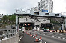
Traditional Chinese 長青隧道
Simplified Chinese 长青隧道
Hong Kong Marathon at Cheung Tsing Tunnel

Cheung Tsing Tunnel, also spelt Cheung Ching Tunnel, is a dual tube 3-lane tunnel on Tsing Yi Island, Hong Kong. It is part of Tsing Kwai Highway of Route 3. Its east end connects to Rambler Channel Bridge and west Cheung Tsing Highway. The tunnel was opened on 1997-05-22 and is the second toll-free tunnel in Hong Kong. Its length is about 1.6 kilometres.

Construction

The tunnel was given the name "Cheung Ching" (長青) because it is beneath Cheung Ching Estate, the first public housing estate on the island.

Construction through the granite of Tsing Yi Peak, required explosives to get through hardness of the hill. To prevent dislodging of rocks and buildings on the surface slopes the rocks were reinforced by concrete and steel. Although the tunnel used explosives in its construction, boring was more used as the primary digging procedure.

Management

The tunnel was managed by Tsing Ma Management Limited under Tsing Ma Control Area, along with Tsing Ma Bridge, Kap Shui Mun Bridge, Ting Kau Bridge, Rambler Channel Bridge, North Lantau Highway and Tsing Kwai Highway.

The traffic of the tunnel is monitored in the buildings at both end, namely East Portal and West Portal Buildings.

External links

Cheung Tsing Tunnel
Hong Kong Route 3 Chronology
HK Route3.svg
Preceded by
Cheung Tsing Bridge
Cheung Tsing Tunnel Succeeded by
Cheung Tsing Highway


Coordinates: 22°20′56″N 114°06′43″E / 22.34877°N 114.11188°E / 22.34877; 114.11188


Wikimedia Foundation. 2010.

Игры ⚽ Поможем написать курсовую

Look at other dictionaries:

  • Cheung Tsing Highway — Major junctions From: Cheung Tsing Tunnel To: North West Tsing Yi Interchange Cheung Tsing Highway (traditional Chinese: 長青公路; simplified Chinese: 长青公路; …   Wikipedia

  • Cheung Tsing Bridge — is on the left Traditional Chinese 長青橋 …   Wikipedia

  • Tsing Yi Peak — (zh c|c=青衣山, or Tsing I Peak formerly) or Sam Chi Heung (三支香) is a hill with three peaks occupying the southern half of the Tsing Yi Island, Hong Kong. The hill is situated on the western half of Victoria Harbour. Its peaks are good locations to… …   Wikipedia

  • Tsing Ma Control Area — (Chinese: 青馬管制區, TMCA) is an area covering Lantau Link and related road networks in Hong Kong, including Tsing Ma Bridge, Ting Kau Bridge, Rambler Channel Bridge, Kap Shui Mun Bridge, Cheung Tsing Tunnel, Tsing Kwai Highway and North Lantau… …   Wikipedia

  • Tsing Kwai Highway — (zh cpcy|c=青葵公路|p=Qīngkuí Gōnglù|cy=ching1 kwai4 gung1 lou6) is a section of Route 3 in Hong Kong, previously known as Route 3 Kwai Chung Section. From its junction with West Kowloon Highway at Mei Foo Roundabout, the expressway runs in the form… …   Wikipedia

  • Tsing Long Highway — (zh cpcy|c=青朗公路|p=Qīnglǎng Gōnglù|cy=ching1 long5 gung1 lou6) is an expressway of Route 3 from North West Tsing Yi Interchange on Tsing Yi Island to Yuen Long, in Hong Kong. Ting Kau Bridge and Tai Lam Tunnel are part of the expressway. It… …   Wikipedia

  • Tsing Yi — For a type of fish called tsing yi, see Green Wrasse. Tsing Yi Tsing Yi, viewed from Shek Lung Kung Geography Location Central New Territories Area 10.69 km2 …   Wikipedia

  • Public housing estates on Tsing Yi Island — Public Housing Estates on Tsing Yi Island, Hong Kong including Home Ownership Scheme (HOS), Private Sector Participation Scheme (PSPS), Tenants Purchase Scheme (TPS), Flat for Sale Scheme (FFSS) Constituency map, showing approx location of… …   Wikipedia

  • Nam Wan Tunnel — entrance. Traditional Chinese 南灣隧道 Simplified Chinese …   Wikipedia

  • Tsing Ma Bridge — at night Official name Tsing Ma Bridge Carries 6 lanes of roadway (upper) 2 MTR rail tracks, 2 lanes of roadway (lower) …   Wikipedia

Share the article and excerpts

Direct link
Do a right-click on the link above
and select “Copy Link”