- Milecastle 0
-
Coordinates: 54°59′16″N 1°31′56″W / 54.98791°N 1.53231°W
Milecastle 0 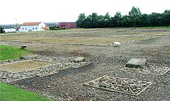
Segedunum - If Milecastle 0 had existed, it would have been located here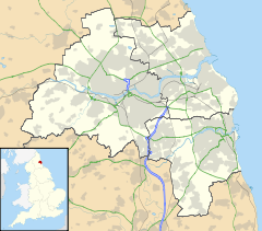
 Milecastle 0
 Milecastle 0 shown within Tyne and Wear
OS grid reference NZ300660 List of places: UK • England • Tyne and Wear 
This article is part of the series on:
Military of ancient Rome (portal)
753 BC – AD 476Structural history Roman army (unit types and ranks, legions, auxiliaries, generals) Roman navy (fleets, admirals) Campaign history Lists of wars and battles Decorations and punishments Technological history Military engineering (castra, siege engines, arches, roads) Political history Strategy and tactics Infantry tactics Frontiers and fortifications (limes, Hadrian's Wall) Milecastle 0 is a possible milecastle of the Roman Hadrian's Wall which may have preexisted the fort of Segedunum. Although its existence has been suggested by historian Peter Hill,[1] no evidence of this milecastle has been found. It is not known whether the decision to establish forts on the line of the wall predated the decision to extend the wall to Wallsend, so it is possible that this milecastle was never built.
Contents
Construction
Nothing is known of the construction of Milecastle 0.
Excavations and investigations
No excavations or investigations have taken place specifically for Milecastle 0. No evidence has been found during excavation of Segedunum.
Associated Turrets
Each milecastle on Hadrian's Wall had two associated turret structures. These turrets were positioned approximately one-third and two-thirds of a Roman mile to the west of the Milecastle, and would probably have been manned by part of the milecastle's garrison. The turrets associated with Milecastle 0 are known as Turret 0A and Turret 0B.
Turret 0A
Nothing is known of this Turret.
Presumed site: 54°59′14″N 1°32′12″W / 54.987261°N 1.536619°WTurret 0B
Turret 0B (St Francis) is located east of St Francis Community Centre.[2] It was first noted by John Horsley in 1732 who mistook it for Milecastle 1, and it is sometimes referred to as Horseley's Milecastle 1.[3]
Eric Birley (still understanding it to be Milecastle 1) considered that it was rediscovered by Canon Fowler in 1877,[4] and the structure was also recorded (and identified as a Turret) by John Collingwood-Bruce[5] and Robert Blair [6] , when it was discovered during the digging for foundations of 'The Grange'. The Turret was confirmed as such by Grace Simpson with reference to an article in The Evening Chronicle on 15 August 1936, which described an extension of Stotts Road, Walker which cut through 'the Roman Wall and one of its turrets near the Grange'. The turret's stones were later removed to Carville Chapel grounds to form rock gardens.[7]A single course of this Turret was unearthed in 1978.[2]
Location: 54°59′07″N 1°32′36″W / 54.985265°N 1.543440°WMonument Records
Monument Monument Number National Monuments Record Number Milecastle 0 None None Turret 0A 24774 (alternative - 26532) NZ 26 NE 1 (alternative - NZ 36 NW 7) Turret 0B 24777 NZ 26 NE 2 References
- ^ Society of Antiquaries of Newcastle upon Tyne (2001), Archaeologia Aeliana : or miscellaneous tracts relating to antiquity (5th Series - Vol. 29 - 2001), Society of Antiquaries of Newcastle upon Tyne, pp. 3–18
- ^ a b Breeze, David J (1934), Handbook to the Roman Wall (14th Revised edition - Nov 2006), Society of Antiquaries of Newcastle upon Tyne, ISBN 0901082651
- ^ Horsley, John (1732), Britannia Romana, London: John Osborne and Thomas Longman
- ^ Society of Antiquaries of Newcastle upon Tyne (1960), Archaeologia Aeliana : or miscellaneous tracts relating to antiquity (4th Series - Vol. 38 - 1960), Society of Antiquaries of Newcastle upon Tyne, pp. 40–46
- ^ Society of Antiquaries of Newcastle upon Tyne (1886), Archaeologia Aeliana : Proceedings of the Society of Antiquaries of Newcastle upon Tyne (Vol. 2 - 1886), Society of Antiquaries of Newcastle upon Tyne, pp. 190
- ^ Blair, Robert (1895), Handbook to the Roman Wall (4th edition), Society of Antiquaries of Newcastle upon Tyne, pp. 40–46
- ^ Society of Antiquaries of Newcastle upon Tyne (1975), Archaeologia Aeliana : or miscellaneous tracts relating to antiquity (5th Series - Vol. 3 - 1975), Society of Antiquaries of Newcastle upon Tyne, pp. 105–115
Bibliography
- Daniels, Charles (1979), "Review: Fact and Theory on Hadrian's Wall", Britannia 10: 357–364, JSTOR 526069
Milecastles of Hadrian's Wall Milecastles 0 • 1 • 2 • 3 • 4 • 5 • 6 • 7 • 8 • 9 • 10 • 11 • 12 • 13 • 14 • 15 • 16 • 17 • 18 • 19 • 20 • 21 • 22 • 23 • 24 • 25 • 26 • 27 • 28 • 29 • 30 • 31 • 32 • 33 • 34 • 35 • 36 • 37 • 38 • 39 • 40 • 41 • 42 • 43 • 44 • 45 • 46 • 47 • 48 • 49 • 50 • 50TW • 51 • 52 • 53 • 54 • 55 • 56 • 57 • 58 • 59 • 60 • 61 • 62 • 63 • 64 • 65 • 66 • 67 • 68 • 69 • 70 • 71 • 72 • 73 • 74 • 75 • 76 • 77 • 78 • 79 • 80
Milefortlets MF 1 • MF 2 • MF 3 • MF 4 • MF 5 • MF 6 • MF 7 • MF 8 • MF 9 • MF 10 • MF 11 • MF 12 • MF 13 • MF 14 • MF 15 • MF 16 • MF 17 • MF 18 • MF 19 • MF 20 • MF 21 • MF 22 • MF 23 • MF 24 • MF 25 • MF 26Other structures on Hadrian's Wall Portgate • Chesters Bridge • Knag Burn Gateway • Peel Gap Tower • Willowford Bridge • Pike Hill Signal TowerCategories:- Milecastles of Hadrian's Wall


Wikimedia Foundation. 2010.