Pass of Drumochter

Pass of Drumochter
Pass of Drumochter from the south. March 2007
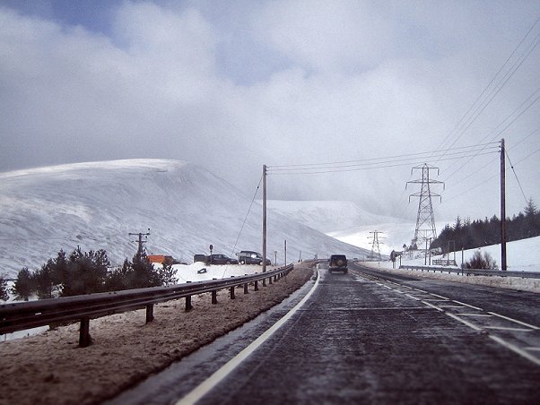
Image of the road in winter. February 2005

The Pass of Drumochter (Scottish Gaelic: Bealach Druim Uachdair) is the main mountain pass between the northern and southern central Scottish Highlands. The A9 road passes through here, as does the Highland Main Line, the railway between Inverness and the south of Scotland. The Sustrans National Cycle Route 7 between Glasgow and Inverness also runs through the pass.

It is the high point on the A9, at 460m (1508 ft.), and in winter can be subject to severe weather conditions. Routine winter patrols take place between November and March[1] and the road is occasionally closed with snow gates near Dalwhinnie and Dalnacardoch. The summit of the railway line is 452m (1480 ft.), making it the highest in the UK. The route through the pass has been used since prehistoric times. It is used by the RAF as a main route for low level flying and Tornados and other fast jets may often be seen here.

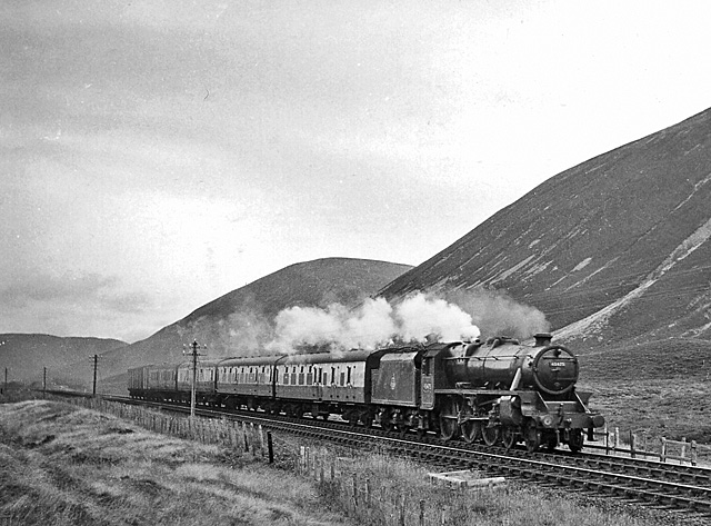
Train near Drumochter Summit in 1957

The pass was formed by glacial action during successive Ice Ages. From this place the River Garry flows to the south, and the River Truim to the north.

It is extremely isolated, and the nearest settlement of any size is Dalwhinnie, a small village.

The highest point on the pass marks the boundary between Perth and Kinross and the Highland Council area. A sign at this point says "Welcome to the Highlands/Fàilte don Ghàidhealtachd", although this is the boundary for the authority rather than for the Scottish highlands which extend further south of here.

References

External links

Coordinates: 56°51′35″N 4°14′55″W / 56.85964°N 4.24856°W / 56.85964; -4.24856


Wikimedia Foundation. 2010.

Игры ⚽ Нужно решить контрольную?

Look at other dictionaries:

  • The Sow of Atholl — Meall an Dobharchain Seen from A9 road at the summit of the Pass of Drumochter …   Wikipedia

  • Sgairneach Mhòr — Infobox Mountain Name = Sgairneach Mhòr Photo = Sgairneach Mhor from Sow of Atholl.jpg Caption = Sgairneach Mhòr seen from The Sow of Atholl, 3 km to the east. Elevation = 991 m (3251 ft) Location = Perth and Kinross SCO Range = Grampian… …   Wikipedia

  • A' Mharconaich — Infobox Mountain Name = A Mharconaich Photo = A Mharconaich from the south.jpg Caption = A Mharconaich from the south, the track up Coire Dhomhain is clearly in view. Elevation = 975 m (3199 ft) Location = Badenoch and Strathspey Highland SCO… …   Wikipedia

  • A' Bhuidheanach Bheag — Infobox Mountain Name = A Bhuidheanach Bheag Photo = A Bhuidheanach Beag from Sow.jpg Caption = A Bhuidheanach Bheag seen across the Pass of Drumochter from The Sow of Atholl. Elevation = 936 m (3071 ft) Location = Atholl, Perth and Kinross SCO… …   Wikipedia

  • Old military roads of Scotland — The remains of one of the military roads near the Corrieyairack Pass A network of military roads was constructed in the Scottish Highlands during the middle part of the 18th century as part of an attempt by the British Government to bring order… …   Wikipedia

  • National Cycle Route 7 — (or NCR 7) is a route of the National Cycle Network, running from Carlisle to Inverness. Contents 1 Route 1.1 Carlisle to Glasgow 1.2 Glasgow to Pitlochry 1.3 …   Wikipedia

  • Highland Main Line — The Highland Main Line is a railway line in Scotland. It is 190 km (118 miles) long and runs through the Scottish Highlands linking a series of small towns and villages with Perth at one end and Inverness at the other. Today, services between… …   Wikipedia

  • MV Princess Victoria — Career Name: MV Princess Victoria Owner: British Transport Commission[1] …   Wikipedia

  • Slochd Summit — The Slochd Summit is a mountain pass on the A9 road and the Highland Main Line Railway in the Scottish Highlands between Inverness and Aviemore. An old military road also goes through the pass. Both the road and the railway have signs marking the …   Wikipedia

  • Scottish Highlands — The Scottish Highlands (Scottish Gaelic: A Ghàidhealtachd , Scots: Hielans ) include the rugged and mountainous regions of Scotland north and west of the Highland Boundary Fault, although the exact boundaries are not clearly defined, particularly …   Wikipedia

Share the article and excerpts

Direct link
Do a right-click on the link above
and select “Copy Link”