- River Hull
-
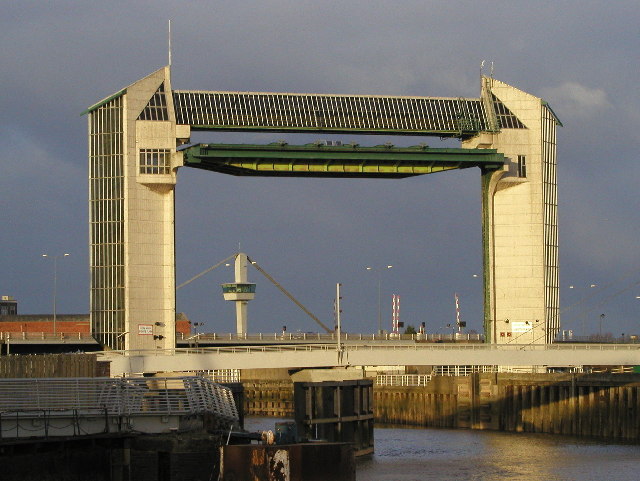
River Hull River  The tidal barrier at the mouth of the river
Country England County East Riding of Yorkshire Source - location Driffield - elevation 65 ft (20 m) Mouth Humber estuary - location Kingston upon Hull - elevation 0 ft (0 m) River Hull Legend

Elmswell Beck 

Little Driffield Beck 
Driffield Trout Stream 
Driffield Railway Bridge 

Feeder 
River Head bridge 
Driffield Basin 
Locks (5) 

Frodingham Beck 

Corpslanding Bridge 
River Hull 

Emmotland Junction 
Bethells Bridge 

Scurf Dyke Driffield Navigation 
Beverley & Barmston Drain 


Struncheon Hill Lock and weir 
River Hull (from here to Humber) 

Aike Beck 

Leven Canal 

Arram Beck 

A1035 New Hull bridge 
Hull bridge 
Grovehill lift bridge, Weel 


Beverley Beck 

A1033 Ennerdale Link bridge Sutton Road Bridge A1165 Stoneferry bridge 

Hull swing railway bridge Wilmington Bridge 
Sculcoates Bridge 

Beverley & Barmston Drain Scott Street Bridge A165 North Bridge 

Dry dock (to Queens Dock) Drypool Bridge 
Drypool basin + Victoria Dock 
A63 Myton Bridge, Hull 
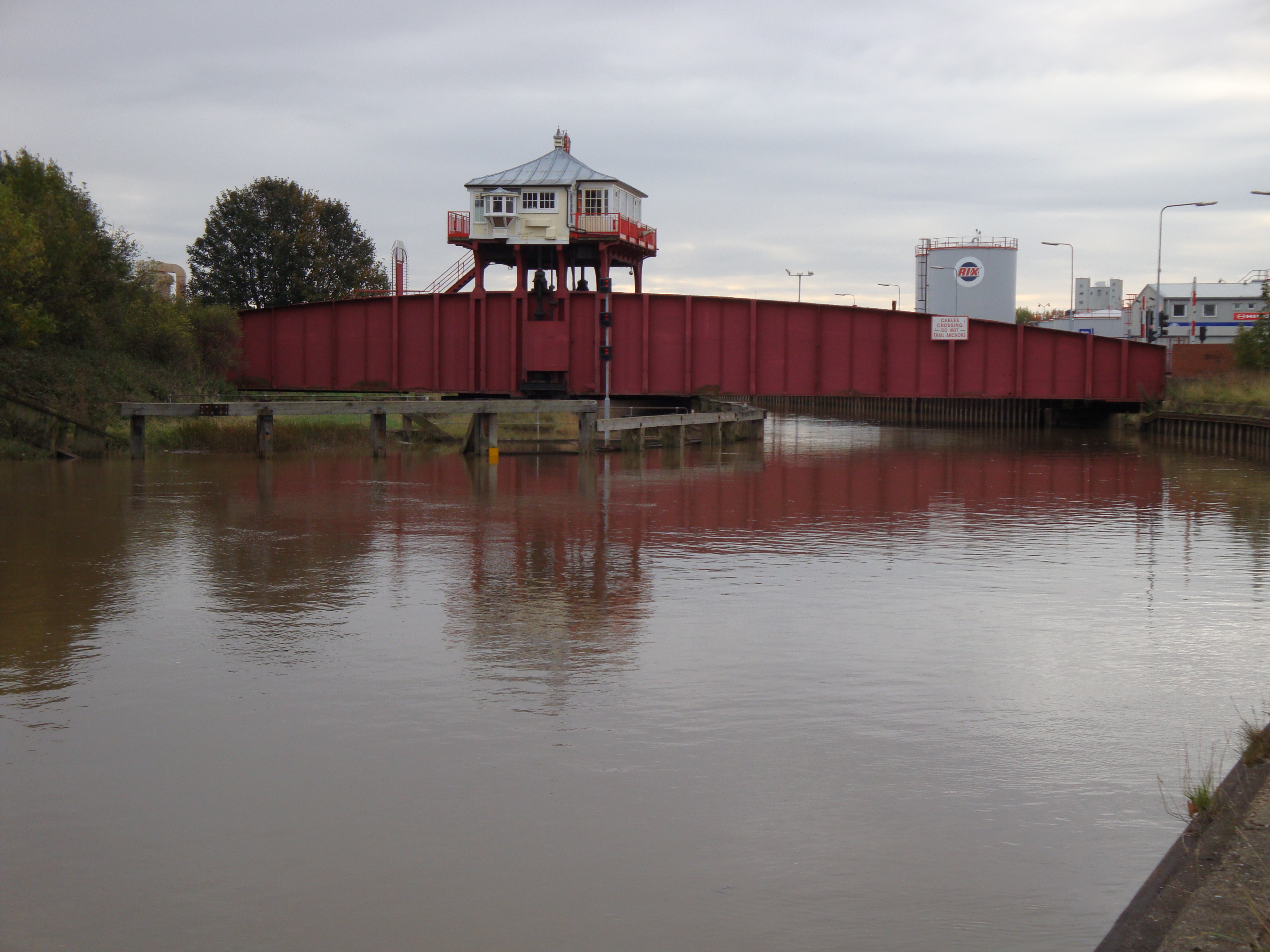
Tidal Barrier 
Humber Estuary The River Hull is a navigable river in the East Riding of Yorkshire in the north of England. It rises from a series of springs to the west of Driffield, and enters the Humber estuary at Kingston upon Hull. Following a period when the Archbishops of York charged tolls for its use, it became a free navigation. The upper reaches became part of the Driffield Navigation from 1770, after which they were again subject to tolls, and the section within the city of Hull came under the jurisdiction of the Port of Hull, with the same result.
Most of its course is through low lying land that is at or just above sea level, and flooding has been a long-standing problem. Drainage schemes to alleviate it were constructed on both sides of the river. The Holderness Drainage scheme to the east was completed in 1772, with a second phase in 1805, and the Beverley and Barmston Drain to the west was completed in 1810. Since 1980, the mouth of the river has been protected by a tidal barrier, which can be closed to prevent tidal surges entering the river system and causing flooding.
Most of the bridges which cross the river are movable, in order to allow shipping to pass. There are five swing bridges, with a sixth one expected to open in 2011, four bascule bridges, two of which have twin leaves, one for each carriageway of the roads which they carry, and three Scherzer lift bridges, which are a type of rolling bascule bridge. Scott Street Bridge, which is now permanently raised, was originally powered from a high pressure water main maintained by the first public power distribution company in the world.
Contents
Course
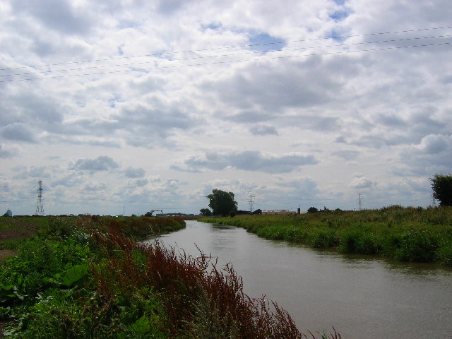
The source of the River Hull is in the Yorkshire Wolds. It rises from a series of springs to the west of Driffield, near the site of the medieval village of Elmswell. The Elmswell Beck flows eastwards from these, and is joined by the Little Driffield Beck, which flows southwards from Little Driffield. It continues as the Driffield Beck, flowing around the south-western edge of Driffield, where it is joined by the Driffield Trout Stream. After the junction, it becomes the River Hull or the West Beck and flows to the east, before turning south to reach Corps Landing. For much of the route below Driffield, the Driffield Navigation runs parallel to the river.[1]
The river from Corps Landing to its mouth is navigable. At Emmotland, it is joined by the Frodingham Beck, which is also navigable, and leads to the canal into Driffield which forms the major part of the Driffield Navigation. Scurf Dyke joins from the west, and is followed by Struncheon Hill lock, which marks the end of the Navigation, and the official start of the navigable River Hull. Below here, the river is tidal, and the tidal range of spring tides can be up to 7 feet (2.1 m) in winter and 4 feet (1.2 m) in summer.[2] Just above the lock, the Beverley and Barmston Drain, which collects water from the catchwater drains on either side of the main channel, flows under the navigation in a tunnel, and runs just to the west of the river almost to its mouth.[3] Below the lock, the surrounding land is almost at sea level, and the river is constrained by flood banks on both sides.[4]
On its route southwards, the river passes the former junction with Aike Beck, once navigable to Lockington Landing, but the stream was subsequently re-routed to join the Arram Beck. The Leven Canal used to join on the east bank, but the entrance lock has been replaced by a sluice. The Arram Beck flows in from the west, and then the river is crossed by Hull Bridge, the cause of repeated disagreement between the owners of the Driffield Navigation, and the Corporation of Beverley, who owned the bridge.[5] Just above Beverley Beck, which joins from the west, is Grovehill bridge, now a lift bridge but once a ferry bridge.[6]
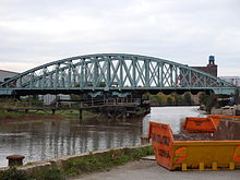 The Hull and Barnsley Railway Bridge, built in 1885
Once the river reaches the outskirts of Hull, its course is marked by a series of bridges, most of which open to allow boats to pass. There are swing bridges, lift bridges and bascule bridges, and the river becomes part of the Port of Hull.[7] The river, which is the dividing line between West and East Hull, bisects the city's industrial area, and the bridges cause traffic delays during high tides, though river traffic is less than it once was. The Beverley and Barmston Drain rejoins the river above Scott Street Bridge.[4] Below North Bridge, an unused dry dock on the west bank marks the former entrance to Queens Dock, and below Drypool Bridge, a muddy basin on the east bank was once the entrance to Drypool Basin and Victoria Dock.[8] The river reaches its confluence with the Humber estuary in the centre of Kingston upon Hull.[4] At its mouth, a tidal barrier has been constructed to prevent tidal surges from entering the river, which can flood the town and the flat countryside to the north.[9]
History
The river Hull has served as a navigation and a drainage channel, and has been subject to the conflicts that this usually creates, where water levels need to be raised for navigation, but lowered for efficient drainage. In 1213, the Archbishops of York laid claim to the river, and declared their right to navigate on a 24-foot (7.3 m) channel. A number of fish-weirs made navigation difficult, and the Archbishop negotiated their removal in 1296, so that a wharf could be established at Grovehill, to serve the town of Beverley. By 1321, river rights had been extended to the charging of tolls. One-third of a shilling (1.7 p) was charged for each bushel carried on the river between Emmotland and the Humber, but the merchants of Hull were unhappy with this, and eventually, it became a free navigation, on which goods could be carried without toll. The Arram Beck was also exempt from all tolls. It has remained free, except for 1 mile (1.6 km) from the mouth, which is part of the Port of Hull and is under the control of Hull Corporation.[10]
The lower river was bordered by salt marshes in medieval times, when efforts were first made to drain them. Further upstream, channels were cut through the fens in the twelfth and thirteenth centuries by the monks of Meaux Abbey, primarily to enable travel by boat, but these gradually became part of the drainage system.[10] John Smeaton, when asked by the merchants of Driffield to advise on ways to allow keels to reach their town, suggested a small cut of about 1.2 miles (1.9 km) including one lock, from the river near Wansford. The merchants sought a second opinion, and John Grundy, Jr. suggested a much longer canal, running for 5 miles (8.0 km) from Fisholme on the Frodingham Beck. When fully opened in 1770, the new route was some 3 miles (4.8 km) shorter than the river, which follows an extremely winding course in its upper reaches.[5] The river above Aike was now considered to be part of the Driffield Navigation, and tolls were charged for its use.[2]
Although beyond their jurisdiction, the Navigation commissioners attempted to extend their powers, to improve the river below the junction with Aike Beck. They particularly wanted to replace the stone Hull Bridge, near Beverley, with a swing bridge, which would make it easier for keels to reach Frodingham bridge. The Corporation of Beverley objected, because the bridge was the main route of communication between Beverley and Holderness, and the commissioners instead dredged parts of the river to improve access.[5] Plans to improve Hull Bridge were again resisted by Beverley Corporation in 1799, but an agreement was finally reached in 1801, and an Act of Parliament was obtained in July of that year. William Chapman acted as engineer, as the act authorised the construction of towpaths, a new cut between Bethels Bridge and the lock at Struncheon Hill, to avoid a long loop in the river, and rebuilding of the bridge. The bridge cost £500, half of which was met by Richard Bethell, the owner of the Leven Canal, on condition that the tolls for passing through it were reduced significantly.[11]
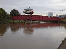 Wilmington Bridge, now used as a cycleway and footbridge
Passage through Hull had long been difficult, because of the number of ships which used the river for loading and unloading goods. In 1794, the merchants of Beverley had advocated the building of docks at Hull, with a separate entrance, so that traffic to the upper river would not be impeded, while the Driffield Navigation had unsuccessful attempted to get a clause inserted into the Act of Parliament which the Hull Dock Company obtained in 1840, to ensure free passage for vessels, and the removal of tolls for boats not actually using the docks. The Navigation Company also received complaints from the Beverley and Barmston Drainage Commissioners, who believed that water levels were being kept at a higher level than was good for drainage.[11]
In 1980, the Environment Agency constructed a tidal barrier at the mouth of the river. The structure spans the river, and a huge steel gate, weighing 202 tonnes, can be lowered into the waterway, effectively sealing the river from the Humber, and preventing tidal surges from moving up the river and flooding parts of the city and the low lying areas beyond. The gate is lowered between eight and twelve times a year,[9] and protects around 17,000 properties. In 2009, a £10 million upgrade of the structure was started, to ensure it would stay operational for a further 30 years. The upgrade included a new drive mechanism, which raises and lowers the gate, and pivots it when it is at the top of the structure, so that it lies horizontally rather than vertically. It also included a new control system.[12] Plans have been considered to build a barrage at the mouth of the Hull where it joins the Humber Estuary to maintain a constant water level as it passes through the city. The idea was first raised by the Abercrombie report, which considered how to redevelop Hull after significant destruction during the Second World War. The estimated cost of such a project was around £195 million in 2007.[13][14]
Traffic
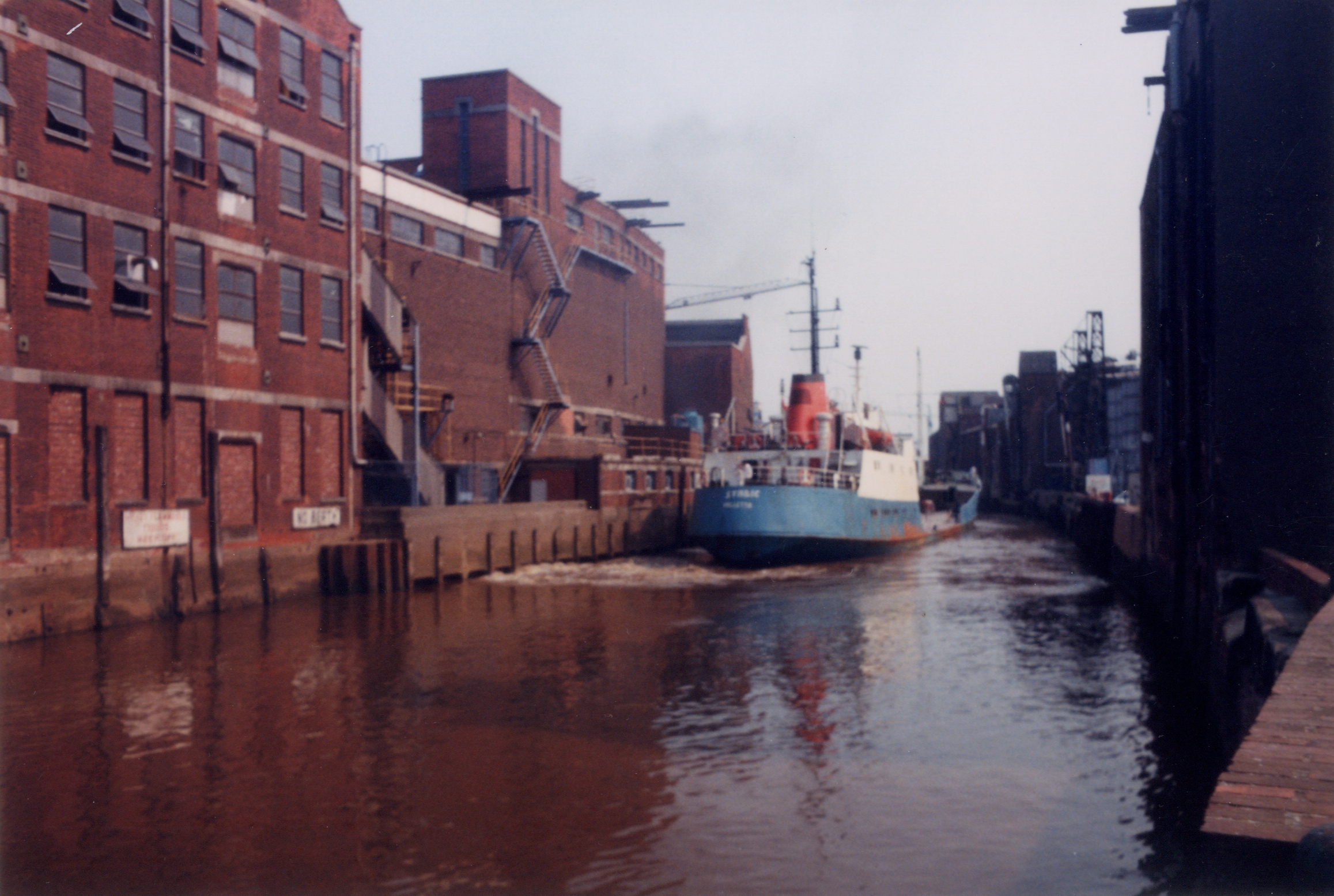
 Freighter near Scott Street Bridge 1990
Because the river was a free river, there are no figures for traffic on the lower river. However, it connected to a number of waterways on which tolls were collected, and so an indication of the traffic can be gained from the figures for these waterways. The main cargoes on Beverley Beck in 1730 were coal, bricks, turfs and wool, together with cereal crops, consisting of wheat, barley, oats and malt. Receipts from tolls more than doubled between 1732 and 1748, after which the tolls were let to an independent collector. The annual rent charged for this privilege doubled again between 1748 and 1792.[15] There was a steady expansion of trade on the Driffield Navigation during the same period, as the dividends paid to shareholders rose from 1.5 to 4 per cent. In 1789, Bainton, Boyes and Co negotiated a lump sum payment to cover coal from the Aire and Calder Navigation to their new carpet factory and the export of their carpets in the downstream direction. The factory later became a corn mill.[16]
Toll rentals continued to increase on the Beverley Beck, rising from £190 to £435 between 1793 and 1835. Some 31,185 tons of cargo were carried in 1838.[17] In 1817, a steam packet service started to run between Driffield and Hull. Three return trips each week were made, but the journey times were too long, and an advertisement in 1825 indicated that the engine had been altered and an express steam packet service would commence. Three boats were recorded as trading between Driffield and Hull every other day in a directory of Yorkshire published in 1823. Traffic for 1832 included 7,394 chaldrons of coal, 18,173 quarters of wheat, 7,745 quarters of oats, 19,396 quarters of barley and 4,555 sacks of flour. An additional 1,564 quarters of wheat and 8,194 sacks of flour were carried to or from Foston Mill, reached from Frodingham Beck.[18] A regular carrier also operated between the Leven Canal and Hull once a week.[19]
Between 1848 and 1905, traffic on Beverley Beck more than trebled, from 33,498 tons to 101,540 tons. Coal and other minerals accounted for around one quarter of the traffic in 1905, while goods carried in 1906 included fertiliser, burnt ore, flour and scrap metal. Commercial traffic continued into the 1970s, when tolls of £2,365 were collected on 28,169 tons of cargo.[20] Traffic on the Driffield Navigation was relatively steady between 1871 and 1905, falling slightly from 35,654 to 32,666 tons. Goods carried included coal, linseed, cottonseed, wheat, flour and artificial manures. In 1922, £7 of income was received from pleasure craft using the navigation. Traffic declined during the 1930s, with commercial traffic finally ceasing in 1944. The Leven canal carried 4,242 tons in 1888 and 4,546 in 1905, but then succumbed to road competition, and closed in 1935.[21]
Drainage
 The River Hull at Wawne
The problems of flooding of the land adjacent to the river were addressed by the construction of catchwater drains to both sides of it. The east side of the river was protected by the Holderness Drainage scheme. John Grundy worked on plans for the scheme which would protect 11,000 acres (4,500 ha) of low-lying land to the north-east of Hull. John Smeaton was also involved, although the final report was largely Grundy's work, and an Act of Parliament to authorise the work was passed on 5 April 1764. The Trustees for the scheme wrote to Grundy and Smeaton in May 1764, asking them to work on the project. Grundy's wife had died only a fortnight previously, and the two engineers corresponded, but besides valuable comment on Grundy's plans for the outfall sluice, Smeaton had no further involvement, and it was Grundy who ran the project, which included 17 miles (27 km) of barrier bank along the east side of the river. John Hoggard acted as Superintendent for the scheme, while Joseph Page was appointed as resident engineer, to oversee the construction of the drains and the outfall sluice. Grundy made regular visits until October 1767, by which time the sluice and the main drainage channels were completed, at which point he and Page moved on, while Hoggard oversaw additional work on the drains and banks, which lasted for several more years. By the time of its completion in 1772, the scheme had cost £24,000.[22]
Despite the Holderness scheme, there were still problems near Leven and Weel, and William Jessop spent a month inspecting the area before writing a report in July 1786. His plan advocated separating the water which fell on the uplands to the north and flowed through the low-lying areas, from the local drainage of those low-lying areas. George Plummer carried out most of the subsequent survey work on Jessop's behalf, although Jessop surveyed the River Hull in 1787, to identify how the outfall could be improved. Jessop visited the works from time to time, making seven visits between 1789 and 1792, while the day to day oversight of the scheme was handled by Plummer as resident engineer. Plummer was succeeded by Anthony Bower, who was engineer from 1792 to 1795, and the whole scheme was completed in 1805, having cost £16,000.[23]
In 1796, Robert Chapman was asked to report on possible solutions for flooding to the west. His report formed the basis for the Beverley and Barmston Drainage Act, which was passed by Parliament in June 1798. Chapman was appointed as engineer for the scheme, which would cost £115,000, and would provide flood defences and drainage for 12,600 acres (5,100 ha) of land to the west of the river. The project included the construction of 23 miles (37 km) of drainage cuts, and building embankments along 20 miles (32 km) of the river. At Hull, an outfall sluice was constructed, and the drain passed through tunnels under eleven waterways, including the Beverley Beck. 27 bridges were built to carry roads over the drain, and the whole project was finished in 1810.[24]
River crossings
There are several bridges in the Hull area which cross the river Hull. Details of them are shown in the following table, starting from that furthest north and moving south to the river mouth.
Bridge Date built Notes New Hull Bridge 1974[25] A fixed flat deck concrete bridge, carrying the A1035 Tickton bypass Hull Bridge 1976 A fixed foot bridge, which replaced a 1913-built steel rolling bridge once Tickton bypass opened. Grovehill Bridge 1953[6] A truss-girder lift bridge, which replaced a ferry bridge Ennerdale Link Bridges[26] 1997 Twin bascule bridges, one for each direction of traffic. On Raich Carter Way (A1033), they replaced an aborted attempt to construct a tunnel under the River. Sutton Road Bridge 1939[27] A Scherzer type rolling lift bridge. Built by the Cleveland Bridge and Engineering Co, with elegant Art Deco / Neo-Georgian style operating houses. Stoneferry Bridge 1988–91[28] Twin bascule bridges with 105-foot (32 m) leaves, one for each direction of traffic. Designed by Rendel Palmer and Tritton, and built by Cementation Construction. Replaced a 1905 swing bridge, and earlier ferry, thought to have originally been a ford at this point. Hull Bridge 1885 Steel bowstring span swing bridge. Grade II Listed 1994. Built by the Hull and Barnsley Railway in 1885, still used by freight trains.[29] Wilmington Swing Bridge 1907 A Grade II Listed railway swing bridge, built by the North Eastern Railway. It opened on 7 May 1907, and replaced the original 1853 bridge. Railway use ceased in 1968, and it is now used as a footpath and cycleway.[30] Sculcoates Bridge 1874 A wrought iron swing bridge, Grade II listed in 1994.[31] This is the oldest river bridge in the city. Scott Street Bridge 1901 A double bascule bridge. The bridge, bridgemasters hut, railings and lamps were Grade II listed in 1994.[32] It has been permanently raised since 1994 as the structure is too weak to carry traffic. North Bridge 1928–32 A Scherzer rolling lift bridge (or "Walking lift bridge"), Grade II listed[33] The previous North Bridge was a swing bridge connecting Charlotte Street and Witham around 55 yards (50 m) south.[34] There has been a bridge at this point (close to the North Gate of the city walls) since 1541, before which there was a ferry. The bridge here has been modified, rebuilt and enlarged several times.[35] Drypool Bridge 1961 Scherzer rolling lift bridge - a type of Bascule bridge[36] Replaced an earlier swing bridge, also known as Drypool bridge or Salthouse Lane bridge, sanctioned 1885, opened 1889[37][35][38] Image.[39] Scale Lane Bridge[40] 2011 (?) Pedestrian swing bridge between Scale Lane (west) and Tower street (east). (under construction, expected opening August 2011)[41][42] Myton Bridge 1981[43] An asymmetric cable stayed box girder steel swing bridge on the A63 Garrison Road, with spans of 182.2 and 93.4 feet (55.5 and 28.5 m).[44][45][46] South Bridge
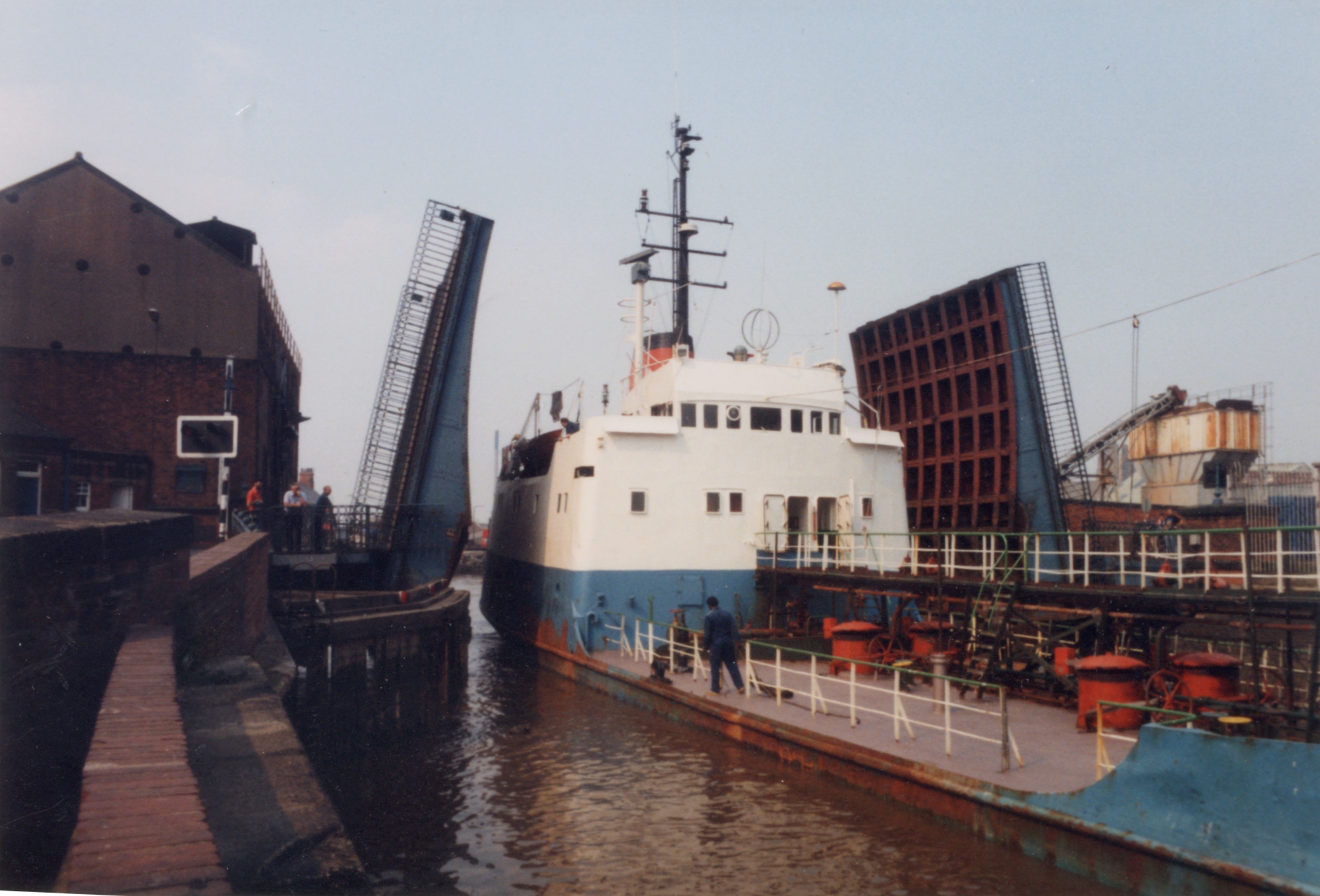
defunct1865-1944 Toll bridge. Also know as the "Ha'penny Bridge", it was built to give better access to the newly built Victoria Dock. Closed 1934.[47] Swing bridge located between Blackfriargate and Humber Street (between present Myton Bridge and Tidal Barrier).[48] Image.[49] Millennium Bridge[50] 2001 A pedestrian swing bridge giving access to The Deep, with a span of 102 feet (31 m) 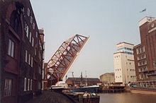 Drypool Bridge, raised to allow a freighter to pass
The present Drypool bridge was designed by W. Morris, the Hull City Engineer, and it was built in Hull. The previous wrought iron swing bridge, which had opened in 1888, was too narrow, with a carriageway which was 16 feet (4.9 m) wide.[51] It was closed in May 1959, so that it could be demolished[52] and Morris's new bridge opened in March 1961.[53]
Scott Street bridge had gradually deteriorated, and a public consultation was held in 1986, to determine its future. By that time a 10-ton weight limit had been imposed on traffic using the bridge, because of its poor structural state. Three suggestions were made as to its future. These were to close and demolish it, to refurbish it at an estimated cost of £1.6 million, and to build a new bridge on the same site but a different alignment, to eliminate the awkward turn at the west end, which was costed at £2 million.[54] None of these actions have been taken, as the bridge leaves were raised in 1994, and have remained raised ever since. Consideration was given in 2007 to preserving two of the hydraulic rams which operated the bridge, during planning to demolish the structure. The Hull Hydraulic Power Company was set up in 1872, and by 1876 was operating a pumping station on Machell Street. This supplied water to a high pressure main which ran from Wellington Street to Sculcoates bridge, and was used by local industries to power machinery, including the bridge when it was constructed. Although the power company closed in the 1940s, it made Hull the first city in the world to have a public system of power distribution.[55]
 Scott Street Bridge 1990
The design for the Ennerdale Link road included a tunnel under the river. Initial investigations suggested that there was a layer of boulder clay below the alluvium of the river bed, and that a chalk aquifer was below the clay.[56] Construction work started in July 1991.[57] A cofferdam was built on the east bank, and the cutting which would have provided access to the twin-bore tunnel was nearly excavated when a 6.6-foot (2.0 m) hole appeared in the river bed, and the entire site flooded. A 3-month investigation took place, which suggested that it would be difficult to finish the tunnel and maintain the integrity of the aquifer. Despite some £10 million having been spent on the project, it was abandoned[56] in 1993.[57] A contract for a replacement bridge was awarded in June 1995[58] and the river was crossed by twin lift bridges, which were opened in April 1997. The project had cost £30 million, compared to an original budget of just £13 million.[57]
A tunnel was successfully constructed under the river in 2001. The 6.2-mile (10.0 km) long sewer runs from the city centre to a treatment works at Salt End. It was excavated using two tunnelling machines, which were manufactured in Canada and were named Maureen and Gloria. The tunnel was officially opened on 21 August 2001, when a Mini car was driven through it, recreating scenes from the film The Italian Job, released in 1969 and starring Michael Caine.[59]
Prior to 1897, there had been a ferry at Grovehill, and a shipyard on the east bank, owned by Joseph Scarr. In order to assist his workers to reach the shipyard, Scarr designed and built a ferry bridge, which cost him £300.[60] It consisted of a large rectangular pontoon, above which was fitted a bridge deck with handrails. Two jack screws enabled the deck to be raised or lowered in relation to the pontoon, so that it remained at approximately the same height, whatever the state of the tide. On the eastern bank, Scarr constructed a variable-height landing, but the landing on the west bank was constructed by Beverley Council, and was fixed. Scarr campaigned to have a variable landing here as well, and was prepared to fund it, but his requests were always rejected. The fixed landing made access to the bridge difficult at high tides.[61] When a boat needed to pass, the west end was freed, and the pontoon swung round to lie parallel to the bank, either upstream or downstream, depending on the state of the tide. It would then be winched back into position by a small barrel winch. At night the bridge was closed and moored beside the bank.[62]
Responsibility for the bridge was taken over by Beverley Council before the Second World War. Its condition deteriorated, and in 1948, they attempted to replace it with a footbridge around 400 yards (370 m) further upstream. Because the ferry rights had been in existence for more than 600 years, an Act of Parliament was needed, and this was thwarted by a petition containing 84 signatures, presented by the people of Weel to the House of Lords. Plans for a new lift bridge were drawn up, and it was opened on 19 October 1953.[63]
In 1913, the Hull Bridge upstream of Beverley, which had caused so much disagreement in the 18th century until it had been replaced in 1801, was demolished by the County Council, who installed a steel rolling bridge in its place. Once the Tickton Bypass bridge had been built a short distance upstream, it no longer needed to carry road traffic, and it was replaced by a footbridge in 1976.[25]
At the other end of the river, the Millenium Bridge was opened in 2001. There was once a ferry at this point, prior to 1865,[64] which gave access to the Victoria Dock, opened in 1850. South Bridge replaced the ferry in 1865, making it easier for workers to reach the dock. The swing footbridge was closed in 1934, but was not demolished until 1944.[65]
Points of interest
Point Coordinates
(Links to map resources)OS Grid Ref Notes Source 54°00′29″N 0°28′32″W / 54.0081°N 0.4755°W TA000579 Springs near Elmswell Driffield Railway bridge 53°59′42″N 0°26′16″W / 53.9949°N 0.4377°W TA025565 River Hull below here Corpslanding 53°57′41″N 0°22′49″W / 53.9614°N 0.3803°W TA063529 Limit of navigation Emmotland Junction 53°57′03″N 0°21′10″W / 53.9509°N 0.3527°W TA082517 Frodingham Beck Struncheon Hill lock 53°56′02″N 0°21′26″W / 53.9339°N 0.3571°W TA079498 Driffield Navigation Leven Canal 53°53′23″N 0°23′42″W / 53.8896°N 0.3949°W TA055449 disused entrance lock Beverley Beck 53°50′24″N 0°23′41″W / 53.8399°N 0.3946°W TA057393 entrance lock Ennerdale Link bridge 53°47′38″N 0°21′32″W / 53.7938°N 0.3589°W TA082343 A1033 Stoneferry bridge 53°46′03″N 0°19′49″W / 53.7675°N 0.3302°W TA101314 A1165 Beverley & Barmston Drain 53°45′06″N 0°19′58″W / 53.7518°N 0.3329°W TA100296 Sluice Tidal Barrier 53°44′24″N 0°19′51″W / 53.7399°N 0.3307°W TA101283 Just above River Humber See also
- Rivers of the United Kingdom
Bibliography
- Allison, K. J., ed (1969). "22. Communications : Bridges". A History of the County of York East Riding: Volume 1: The City of Kingston upon Hull. British History Online. http://www.british-history.ac.uk/report.aspx?compid=66785#s3.
- Allison, K. J., ed (1989). "41. Boundaries and Communications : Roads and Bridges". A History of the County of York East Riding: Volume 6: The borough and liberties of Beverley. British History Online. http://www.british-history.ac.uk/report.aspx?compid=36437#s8. Retrieved 18 November 2010.
- Crosby, Kathleen (1980). The Old Grovehill Ferry Bridge. Lockington Publishing Co. ISBN 0-90549-015-0.
- Cumberlidge, Jane (2009). Inland Waterways of Great Britain (8th Ed.). Imray Laurie Norie and Wilson. ISBN 978-1-84623-010-3.
- Hadfield, Charles (1972). The Canals of Yorkshire and North East England (Vol 1). David and Charles. ISBN 0-7153-5719-0.
- Hadfield, Charles (1973). The Canals of Yorkshire and North East England (Vol 2). David and Charles. ISBN 0-7153-5975-4.
- Hollis, Tracey (23 January 2008). "Hull barrier used to drain water from east Yorkshire’s floodplains". Environment Agency. http://www.environment-agency.gov.uk/news/57550.aspx.
- McNicol, Colin (2002). "Hull's Victoria Dock Village". Highgate Publications (Beverley). ISBN 978-1-90264524-7. http://www.vdvh.co.uk/historyofthedock.html.
- Skempton, Sir Alec (2002). A Biographical Dictionary of Civil Engineers in Great Britain and Ireland: Vol 1: 1500 to 1830. Thomas Telford. ISBN 0-7277-2939-X.
References
- ^ Ordnance Survey, 1:25,000 Explorer map, Sheets 294, 295
- ^ a b Cumberlidge 2009, pp. 114–115
- ^ Hadfield 1972, p. 85
- ^ a b c Ordnance Survey, 1:25,000 Explorer map, Sheet 293
- ^ a b c Hadfield 1972, pp. 86–89
- ^ a b Crosby 1980, p. 31
- ^ Cumberlidge 2009, p. 153
- ^ Ordnance Survey, 1:10,560 map, 1938/46 edition
- ^ a b Hollis 2008
- ^ a b Hadfield 1972, pp. 83–84
- ^ a b Hadfield 1973, pp. 298–306
- ^ "News". New Civil Engineer. 22 June 2009. http://www.nce.co.uk/news/water/hull-tidal-barrier-gets-10m-overhaul/5203851.article.
- ^ Alexandra Wood (17 April 2007). "Cost of fitting lock system on River Hull put at £195m". Yorkshire Post. http://www.yorkshirepost.co.uk/localnews/Cost-of-fitting-lock-system.2707125.jp.
- ^ "Environment and Transport Overview and Scrutiny Commission Minutes 74: River Hull And Humber Strategies". Hull City Council. 5 February 2008. https://web5.hullcc.gov.uk/akshull/users/public/admin/kab12.pl?cmte=ETO&meet=20&arc=14.
- ^ Hadfield 1972, pp. 84–86
- ^ Hadfield 1972, pp. 88–89
- ^ Hadfield 1972, p. 300
- ^ Hadfield 1972, pp. 304–305
- ^ Hadfield 1972, p. 308
- ^ Hadfield 1972, pp. 429–430
- ^ Hadfield 1972, pp. 432–433
- ^ Skempton 2002, p. 281
- ^ Skempton 2002, pp. 368–372
- ^ Skempton 2002, p. 126
- ^ a b Allison 1989, pp. 161–169
- ^ "Moveable bridges". Corus Group. http://www.corusconstruction.com/en/reference/teaching_resources/bridges/21st_century_bridges/moveable/. Retrieved 18 November 2010.
- ^ "List of historically interesting structures in Hull - Sutton Road Bridge". Hull City Council. https://web5.hullcc.gov.uk/akshull/images/att3315.xls. Retrieved 18 November 2010.
- ^ Nicolas Janberg. "Structures - Stoneferry Bridge". Structurae. http://en.structurae.de/structures/data/index.cfm?ID=s0013305. Retrieved 18 November 2010.
- ^ Details from listed building database (387451) . Images of England. English Heritage. River Hull Railway Bridge, Bankside
- ^ Mark Dyson. "Site Record: Sculcoates Station". Disused Stations. http://www.disused-stations.org.uk/s/sculcoates/index.shtml. Retrieved 4 December 2010.
- ^ Details from listed building database (387778) . Images of England. English Heritage. Sculcoates bridge
- ^ Details from listed building database (387777) . Images of England. English Heritage. Scott Street bridge
- ^ Details from listed building database (387563) New North Bridge, George Street. Images of England. English Heritage.
- ^ 53°44′50″N 0°19′46″W / 53.747269°N 0.329502°W Ordnance survey, 1891, 1:500; also 1938-46, 1:10560 map shows both bridges relative
- ^ a b Allison 1969, pp. 387–397
- ^ Paul Glazzard. "Drypool Bridge, Hull". Geograph Project. http://www.geograph.org.uk/photo/857276. Retrieved 18 November 2010.
- ^ Sources:
- A Proposed New Bridge at Hull. 47. (July to September 1884) 1885. 36. http://books.google.co.uk/books?id=XFYcAQAAMAAJ&q=New+Bridge+at+Hull. "At a meeting of the Bridge Committee of the Hull Corporation last week, the Borough Engineer (Mr. J.F. Sharp) submitted plans for a proposed bridge across the river Hull, between Salthouse-lane Staith and Clarence-street. It is a swing bridge, 133ft long, 35ft in the extreme width and calculated to carry a load of 25 tons."
- Hull. 53. July-December 1903 (1904). 862. http://books.google.co.uk/books?id=xt1QAAAAYAAJ&q=Salthouse. "It is proposed, as an experiment, to work the Salthouse Lane Bridge across the River Hull by electricity"
- The Drypool Bridge, Hull. 69. 1890. 4. http://books.google.co.uk/books?id=R8ghAQAAMAAJ.
- ^ 53°44′43″N 0°19′42″W / 53.745299°N 0.328458°W Ordnance survey, 1892, 1:500
- ^ "Drypool Bridge, Hull". www.lordline.co.uk. http://www.lordline.co.uk/index.php?route=product/product&product_id=167.
- ^ Statutory Instruments, 2008 No. 1373, Highways, England. "The Kingston upon Hull City Council (Scale Lane Bridge) Scheme". The National Archives. http://www.opsi.gov.uk/si/si2008/uksi_20081373_en_1. Retrieved 18 November 2010.
- ^ Hull Daily Mail (17 March 2010). "Bridge will be a link for growth across the city". This is Hull and East Riding. http://www.thisishullandeastriding.co.uk/news/Bridge-link-growth-city/article-1917703-detail/article.html. Retrieved 18 November 2010.
- ^ Hull Daily Mail (15 February 2011). "Delayed £7.5m bridge for Hull's Old Town will finally swing into action". This is Hull and East Riding. http://www.thisishullandeastriding.co.uk/news/Delayed-bridge-swing-action/article-3220912-detail/article.html. Retrieved 8 April 2011.
- ^ Nicolas Janberg. "Structures - Myton Bridge". Structurae. http://en.structurae.de/structures/data/index.cfm?ID=s0005112. Retrieved 18 November 2010.
- ^ Troyano, Leonardo Fernández (2003). Bridge engineering: a global perspective. Thomas Telford publishing. pp. 726 ff. ISBN 9780727732156. http://books.google.co.uk/books?id=0u5G8E3uPUAC&lpg=PA726&dq=myton%20bridge%20hull&pg=PA726#v=onepage&q&f=false.
- ^ "Award Winning Steel Structures". Metal construction (Welding Institute) 14: 68. 1982.
- ^ "Footprints on a global landscape, 150 years of improving the built environment". Hyder Consulting. p. 64. http://www.hyderconsulting.com/AU/Editorial/Downloads/Footprints%20on%20a%20Global%20Landscape%20-%20Part%201.pdf. Retrieved 3 March 2011. "Cable-stayed box-girder swing bridge, main span 83m. Awarded Structural Steel Design Award, British Constructional Steel Association and the British Steel Corporation, 1981."
- ^ Colin McNicol, "History of the Dock", www.vdch.co.uk (Victoria Dock Village Hall Community Association), http://www.vdvh.co.uk/historyofthedock.html
- ^ 53°44′24″N 0°19′51″W / 53.740125°N 0.330772°W, see Ordnance Survey map 1891-92; 1910; 1928, 1:2500
- ^ Joseph A. Johnson, "The Ha'penny Bridge, Hull", www.hullcc.gov.uk (Hull Museums Collections), http://www.hullcc.gov.uk/museumcollections/collections/search-results/display.php?newsearch=new&person=Johnson%2C+Joseph+A.&keywords=&title=&place=&date=&material=&accessionnumber=&Sender=List&Page=&irn=1517
- ^ Projects. "Pedestrian Access Swing Bridge at "The Deep" - Hull". Qualter Hall. http://www.qualterhall.co.uk/projects.php?id=20. Retrieved 18 November 2010.
- ^ Port of Hull Journal, Vol 46, No. 4 1958, p. 4
- ^ Hull Times, 23 May 1959, p.7
- ^ Hull Times, 11 March 1961, p.5
- ^ Yorkshire Post, 11 June 1986
- ^ "Water hydraulic rams at Scott Street Bridge". Hull City Council. 3 July 2007. https://web5.hullcc.gov.uk/akshull/images/att3818.doc. Retrieved 4 December 2010.
- ^ a b David Hayward (June 1993). "Hull Holed Up". New Civil Engineer (quoted on University of the West of England, Groundwater Case Studies). p. 8. http://environment.uwe.ac.uk/geocal/SoilMech/water/WATERCAS.htm#HULL. Retrieved 18 November 2010.
- ^ a b c Phil Booth (24 July 1997). Yorkshire Post: p. 8.
- ^ "Contract awarded for Ennerdale Bridge". Hull Daily Mail. 27 June 1995.
- ^ "Mini to star in 'Hull Job' stunt". BBC News. 16 August 2001. http://news.bbc.co.uk/1/hi/uk/1494939.stm. Retrieved 18 November 2010.
- ^ Crosby 1980, pp. 8–9
- ^ Crosby 1980, pp. 9–14
- ^ Crosby 1980, pp. 19–20
- ^ Crosby 1980, pp. 27–31
- ^ Ordnance Suvery, 1:2500 map, 1856
- ^ McNicol 2002
External links
Categories:- Kingston upon Hull
- Rivers of the East Riding of Yorkshire
- River navigations in the United Kingdom
- Tributaries of the Humber
- Drainage


Wikimedia Foundation. 2010.