- Canelones Department
-
Canelones Department 
Flag
Coat of armsMap of Canelones Department Location of Canelones within Canelones Department
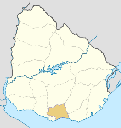

Coordinates (Canelones): 34°36′05″S 55°53′24″W / 34.60139°S 55.89°WCoordinates: 34°36′05″S 55°53′24″W / 34.60139°S 55.89°W Country  Uruguay
Capital of Department Canelones Government – Intendant Marcos Carámbula – Ruling party Frente Amplio Area – Total 4,536 km2 (1,751.4 sq mi) Population (2004 census) – Total 485,240 – Density 107/km2 (277.1/sq mi) Demonym Canario Time zone UYT (UTC-3) ISO 3166 code UY-CA Website imcanelones.gub.uy The Canelones Department (Spanish: Departamento de Canelones), with an area of 4,536 km2 (1,751 sq mi) and 485,240 inhabitants, is located to the south of Uruguay. Its capital is Canelones.
Contents
Geography and climate
Neighbouring departments are Maldonado and Lavalleja to the East, Flores to the North, San José to the West, and Montevideo to the South. Part of the southern border is formed by the Río de la Plata. It is the second smallest department of the country after that of Montevideo, but the second largest in population.
Located in the humid templated region, the average temperature is low compared to that of the rest of the country (around 15°C), as are the levels of precipitation (up to 2,000 mm yearly, on average).
By area Canelones Department is the second smallest of Uruguay's 19 departments.
Topography and hydrography
 Santa Lucía River, at San Ramón.
Canelones Department, is characterized by flat lands and absence of relief (as most parts of Uruguay), with small coastal sand dunes at the south, and with meadows and woods in the center, north and west.[1]
The department is rich in waterways, with many rivers and streams. However, there are two rivers that stand out for their importance: the Santa Lucía River and the Río de la Plata, which is actually a sea of salt water. On the coastline formed by the Río de la Plata, there are many spa towns and their respective beaches.
Santa Lucia River, meanwhile, forms the northern boundary with Florida, which is separated by a bridge known as the Paso Pache.
Regions
Despite being a small department, Canelones has a population of over 500,000 inhabitants and one of the highest densities in the country with 107 inhabitants per square kilometer.[2]
The department is divided into aprox. 20 sections. Within these, there are significant populations centers, some of which have the status of municipality, others are part of recently formed cities by decree, and then there are also those that do not have enough inhabitants and are therefore often considered simple population entities with no mayor or government, remaining under the direct jurisdiction of the Municipality of Canelones (in Spanish, Intendencia Municipal Canelones or Comuna Canaria), which is based in the departmental capital, Canelones.
History
Canelones was one of the nine original departments created in 1830. Over the years its boundaries have changed little.
Economy
Agriculture is one of the principal contributors to the economy of Canelones. The cultivation of grapevines is widespread, and the area is a major contributor to Uruguay's burgeoning wine industry. In addition cereal crops, principally maize are produced, as are a wide variety of fruits and vegetables. Tourism, in the eastern coastal area, is also a major source of income for the department, and has enabled the development of important urban centres, such as Atlántida.
Population and Demographics
As of the census of 2004, there were 485,240 people[3] and 153,931 households in the department. The average household size was 3.2. For every 100 females, there were 96.3 males.[4]
- Population growth rate: 1.862% (2004)
- Birth Rate: 15.27 births/1,000 people (2004)
- Death Rate: 8.10 deaths/1,000 people
- Average age: 31.6 (30.6 Males, 32.7 Females)
- Life Expectancy at Birth (2004)
- Total population: 75.82 years
- Male: 72.17 years
- Female: 79.63 years
- Average Family Size: 2.04 children/woman
- Urban per capita income (cities of 5,000 inhabitants or more): 10,295.2 pesos/month
Main Urban Centres
Population stated as per 2004 census.[5]
City / Town Population Ciudad de la Costa 83,888 Las Piedras 69,222 Pando 24,004 La Paz 19,832 Canelones 19,631 Santa Lucía 16,475 Progreso 15,775 Fracc. Camino Maldonado 15,057 Paso Carrasco 15,028 Barros Blancos 13,553 Colonia Nicolich 8,811 Villa Crespo y San Andrés 8,756 Fracc. Camino del Andaluz y R.84 7,145 San Ramón 6,992 Salinas * 6,574 Joaquín Suárez 6,124 Parque del Plata * 5,900 Sauce 5,797 Tala 4,939 Atlántida * 4,580 Villa Aeroparque 4,434 Toledo 4,028 City / Town Population Empalme Olmos 3,978 San Jacinto 3,909 Santa Rosa 3,660 Pinamar - Pinepark * 3,608 Neptunia * 3,554 Marindia * 2,586 Estación Atlántida * 2,358 Las Toscas * 2,222 Migues 2,180 Cerrillos 2,080 San Bautista 1,880 Dr. Francisco Soca 1,742 Montes 1,713 San Antonio 1,434 Fracc. sobre R.74 1,414 Villa San José 1,407 Juanicó 1,256 Villa Felicidad 1,238 San Luis * 1,224 Estación La Floresta * 1,222 La Floresta * 1,109 Aguas Corrientes 1,095 (* Resorts of the Costa de Oro)
Other towns and villages
Town / Village Population City Golf 854 Costa Azul 826 Barrio Cópola 780 Totoral del Sauce 745 Jardines de Pando 673 Estanque de Pando 641 Castellanos 579 Costa y Guillamón 566 Seis Hermanos 553 Villa Argentina 552 Barrio La Lucha 537 Villa El Tato 508 Rural population
According to the 2004 census, Canelones department has an additional rural poulation of 55,128.
See also
- List of populated places in Uruguay#Canelones Department
References
- ^ Montevideo COMM. "Geografía política - CANELONES" (in Spanish). Enciclopedia Geográfica del Uruguay. http://www.montevideo.com.uy/enciclopedia/canelone.htm. Retrieved 22 april 2011.
- ^ Instituto Nacional de Estadística del Uruguay (INE) (2004). "Censo 2004 Canelones" (in Spanish). http://www.ine.gub.uy/fase1new/Canelones/divulgacion_Canelones.asp.
- ^ 2004 Census of Canelones department - table 7
- ^ Census of Canelones department - table 9
- ^ INE Censo Fase I - 2004 (see p. 36 of 63)
External links
 Canelones Department of UruguayCapital: Canelones
Towns and
villagesAguas Corrientes • Atlántida • Barrio Cópola • Barrio La Lucha • Barros Blancos • Canelones • Castellanos • Cerrillos • City Golf • Ciudad de la Costa • Colonia Nicolich • Costa Azul • Costa y Guillamón • Dr. Francisco Soca • Empalme Olmos • Estación Atlántida • Estanque de Pando • Jardines de Pando • Joaquín Suárez • Juanicó • La Floresta • La Paz • Las Piedras • Las Toscas • Marindia • Migues • Montes • Neptunia • Pando • Parque del Plata • Progreso • Salinas • San Antonio • San Bautista • San Jacinto • San Luis • San Ramón • Santa Lucía • Santa Rosa • Sauce • Seis Hermanos • Tala • Toledo • Totoral del Sauce • Villa Aeroparque • Villa Argentina • Villa Crespo y San Andrés • Villa El Tato • Villa Felicidad • Villa San José

Resorts of the
Ciudad de la CostaEl Pinar • Lomas de Solymar • Solymar • Parque Carrasco • Lagomar • San José de Carrasco • Barra de Carrasco • Shangrilá • Colinas de Solymar • El Bosque
Sights Bridge of the Americas • Carrasco Airport • Lago Calcagno • Parque Roosevelt • Costa de Oro • El Águila • Iglesia Atlántida • Hotel Planeta Palace • Paso de las Toscas
Costa de Oro 
Neptunia • Pinamar-Pinepark • Salinas • Marindia • Fortín de Santa Rosa • Villa Argentina • Atlántida • Las Toscas • Parque del Plata • Las Vegas • La Floresta • Costa Azul • Bello Horizonte • Guazuvirá Nuevo • Guazú-Virá • San Luis • Los Titanes • La Tuna • Araminda • Santa Lucía del Este • Biarritz • Cuchilla Alta • El Galeón • Santa Ana • Argentino • Jaureguiberry
Departments of Uruguay Artigas · Canelones · Cerro Largo · Colonia · Durazno · Flores · Florida · Lavalleja · Maldonado · Montevideo · Paysandú · Río Negro · Rivera · Rocha · Salto · San José · Soriano · Tacuarembó · Treinta y Tres
 Categories:
- Canelones Department
- Departments of Uruguay
- States and territories established in 1816


Wikimedia Foundation. 2010.