- Erpe-Mere
-
Erpe-Mere Localisation of the 8 part-municipalities in Erpe-Mere

Flag
Coat of armsLocation in Belgium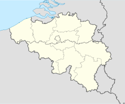
 Erpe-Mere
Coordinates: 50°55′N 03°57′E / 50.917°N 3.95°E Country Belgium Region Flemish Region Community Flemish Community Province East Flanders Arrondissement Aalst Government – Mayor Hugo De Waele (CD&V) – Governing party/ies CD&V, VLD Area – Total 34.03 km2 (13.1 sq mi) Population (1 January 2010)[1] – Total 19,280 – Density 566.6/km2 (1,467.4/sq mi) Postal codes 9420 Aaigem
9420 Bambrugge
9420 Burst
9420 Erondegem
9420 Erpe
9420 Mere
9420 Ottergem
9420 VlekkemArea codes 053 Website www.erpe-mere.be Map of Erpe-Mere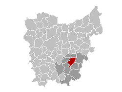
Erpe-Mere is a municipality located in the Belgian province of East Flanders in the Denderstreek. The municipality comprises the towns of Aaigem, Bambrugge, Burst, Erondegem, Erpe, Mere, Ottergem and Vlekkem. There is also a hamlet in Bambrugge: Egem. On January 1, 2010 Erpe-Mere had a total population of 19,280. The total area is 34.03 km² which gives a population density of 567 inhabitants per km². The current mayor of Erpe-Mere is Hugo De Waele, from the CD&V (Christian Democratic) party.
Contents
History
The municipality was formed in 1975 by the merger of the eight sub-municipalities of today, but the sub-communities Erpe and Mere initially disagreed on the new name for the merged municipality. While Erpe had the largest area, Mere was central in the entire area and had more inhabitants. As a compromise they choose the double name Erpe-Mere.
Geography
The municipality is bordered to the north by Lede, in the east by Aalst and Haaltert, in the south by Herzele and in the west by Sint-Lievens-Houtem. Erpe-Mere is located north of the foothills of the Flemish Ardennes, in the region Denderstreek. The area north of the N9 (Aalst-Ghent) is between 10 to 30 meters high, the area between the N9 and E40 (Brussels-Ghent) is between 25 to 50 meters high and the area south of it has hills peaks up to 80 meters. The most famous of them is the Gotegemberg in Mere, not for his height of 68 meters, but for its slope of 18% making it a popular challenge for cyclists.
The territory is traversed by two brooks that both bear the name Molenbeek. The Molenbeek from the Upper Scheldt crosses Burst, Bambrugge, Ottergem, Vlekkem and Erondegem before it flows into the Scheldt. The Molenbeek-Ter Erpenbeek flows into the Dender.
The Romans knew early there was white natural stone called Vlaamse Arduin or Lediaanse Steen in Steenberg of Bambrugge. This white natural stone was suitable as a foundation for the masonry of Roman villas and as building material for columns and capitals of the Roman temples. From about the 11th or 12th century there was already extracted white sandstone in Bambrugge (Steenberg). The common types of white natural stone in Brabant in the 16th to 17th Century were extracted in Steenberg. Extraction continued until after World War II. Today it's the administrative center of Erpe-Mere.
There is a 205 hectare nature reserve called Den Dotter in the sub-municipalities of Aaigem (municipality Erpe-Mere) and Heldergem (municipality Haaltert).
-

The town hall of Erpe-Mere, at Steenberg in Bambrugge
-

The sports hall of Erpe-Mere, at Steenberg in Bambrugge
-

The library of Erpe-Mere, at Steenberg in Bambrugge
-

The pool of Steenberg in Bambrugge
Traffic
Erpe-Mere has an exit to the A10 / E40 and a regional railway station on the railway line Kortrijk - Oudenaarde - Zottegem - Erpe - Mere - Aalst - Brussels. Also the N9 (Gentsesteenweg), the N442 (Leedsesteenweg) and the N46 (Oudenaardsesteenweg) cross the municipality.
-

The motorway bridge (E40) of Mere over the Oudenaardsesteenweg
-

The railway bridge of Erpe over the Oudenaardsesteenweg
 Water tower at Erpe
Landmarks
- The water tower of the Tussengemeentelijke Maatschappij der Vlaanderen voor Watervoorziening.
Mills
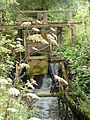
Landmarks include the mills of the municipality, through which runs the Denderroute South and the Molenbeekroute. Due to the geography of the area, there are eleven water mills in Erpe-Mere, with Erpe-Mere having the most water mills in Belgium, seven of which are protected by law. One mill was largely demolished, but there are still remains of this mill and the mill house is still intact. Another mill was also converted into a house. On the Koudenberg, one of the highest hills of the community, there is a windmill that is protected by law. It was re-mounted on its base in 2006 after being restored in 2004 by a studio in Roeselare. The Kruiskoutermolen was restored in 2006 and is operational. It can be visited by appointment with the tourist service.
Place Name(s) Address Type Protected Info Aaigem Engelsmolen
Molen te Dalhem
Molen te DalmeEngelsmolen 1 Overshot watermill  Yes
YesIt was originally a wheat mill, oil mill and a flax attrition mill
Later on it was only a wheat millAaigem Ratmolen
WaterradRatmolenstraat 42 Overshot watermill YesIt was originally a wheat mill and an oil mill
Later on it was only a wheat millAaigem Zwingelmolen Aaigembergstraat 10 Overshot watermill  No
NoIt was originally a flax attrition mill
Later on it became a chicory mill
The mill wheel has been removed
It has been renovated as a houseBambrugge Egemmolen
Meuleken Tik TakEverdal 21 Overshot watermill NoWheat mill
The mill wheel has been removed
The mill house is used as a country cottageBambrugge Molens Van Sande
KasteelmolenPrinsdaal 33 Overshot watermill NoIt was originally a wheat mill and a compulsion mill
Later on it was just a wheat mill
The mill wheel has been removed
It is now an industrial flour millErpe Cottemmolen Molenstraat 36 Overshot watermill YesIt was originally a wheat mill and an oil mill
Later on it was only a wheat millErpe Van Der Biestmolen Dorpsstraat 3 Overshot watermill NoWheat mill Mere De Graevemolen Bosstraat 25 Overshot watermill YesWheat mill and an oil mill Mere Gotegemmolen Gotegemstraat 1 Overshot watermill YesWheat mill Mere Kruiskoutermolen
Jezuïtenmolen
Molen Van Der HaegenSchoolstraat Post windmill with open foot YesWheat mill Mere Molen te Broeck
't Hof SchuurkeWilgendries 6 Overshot watermill YesWheat mill Ottergem De Watermeulen Ruststraat 10-12 Overshot watermill YesIt was originally a wheat mill and an oil mill
Later on it was only a wheat mill-

Engelsmolen at Aaigem
-

Mill wheel of the Engelsmolen at Aaigem
-

Ratmolen at Aaigem
-

Mill wheel of the Ratmolen at Aaigem
-

Zwingelmolen at Aaigem
-

Place where the mill wheel of the Zwingelmolen once was at Aaigem
-

Mill house of the Egemmolen at Bambrugge
-

Remains of the Egemmolen at Bambrugge
-

Front view of the Molens Van Sande at Bambrugge
-

Side-view of the Molens Van Sande at Bambrugge
-

Place where the mill wheel of the Molens Van Sande once was at Bambrugge
-

Front view of the Cottemmolen at Erpe
-

Side-view of the Cottemmolen at Erpe
-

Mill wheel of the Cottemmolen at Erpe
-

Van Der Biestmolen at Erpe
-

Mill wheel of the Van Der Biestmolen at Erpe
-

Front view of the De Graevemolen at Mere
-

Side-view of the De Graevemolen at Mere
-

Mill wheel of the De Graevemolen at Mere
-

Gotegemmolen at Mere
-

Mill wheel of the Gotegemmolen at Mere
-

Kruiskoutermolen at Mere
-

Molen te Broeck at Mere
-

Mill wheel of the Molen te Broeck at Mere
-

Front view of the De Watermeulen at Ottergem
-

Rear view of the De Watermeulen at Ottergem
-
Mill wheel of the De Watermeulen at Ottergem
-

The De Watermeulen inside at Ottergem
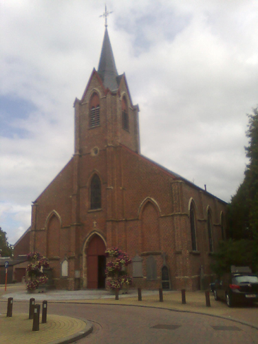
Churches
-
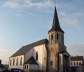
Church of Aaigem
-

Church of Bambrugge
-

Church of Burst
-

Church of Erondegem
-

Church of Erpe
-

Church of Mere
-

Church of Ottergem
-

Church of Vlekkem
Sports
Erpe-Mere once had six football clubs that belonged to the Royal Belgian Football Association. There are still four left: KRC Bambrugge, KFC Olympic Burst, FC Mere and SK Aaigem. Oranje Erpe and Olympia Erondegem merged into KVC Erperondegem that was some years later absorbed by FC Mere. Each year the Steenbergcross, the first international cross-country race, is held at Steenberg in Bambrugge.
Trivia
In the 1990s Walter Baele played on the show Rosa on TV 1 the character Rosa Vermeulen, an older female inhabitant of Erpe-Mere.
References
- ^ Population per municipality on 1 January 2010 (XLS; 221 KB)
External links
 Media related to Erpe-Mere at Wikimedia Commons
- Official website only available in Dutch
 Sub-municipalities: Aaigem · Bambrugge · Burst · Erondegem · Erpe · Mere · Ottergem · Vlekkem
Hamlet: Egem
List of municipalities · Arrondissement of Aalst · East Flanders · Flemish RegionMunicipalities in the Province of East Flanders, Flanders, Belgium Aalst Aalst · Denderleeuw · Erpe-Mere · Geraardsbergen · Haaltert · Herzele · Lede · Ninove · Sint-Lievens-Houtem · Zottegem
Dendermonde Berlare · Buggenhout · Dendermonde · Hamme · Laarne · Lebbeke · Waasmunster · Wetteren · Wichelen · ZeleEeklo Ghent Aalter · Deinze · De Pinte · Destelbergen · Evergem · Gavere · Ghent · Knesselare · Lochristi · Lovendegem · Melle · Merelbeke · Moerbeke · Nazareth · Nevele · Oosterzele · Sint-Martens-Latem · Waarschoot · Wachtebeke · Zomergem · ZulteOudenaarde Brakel · Horebeke · Kluisbergen · Kruishoutem · Lierde · Maarkedal · Oudenaarde · Ronse · Wortegem-Petegem · Zingem · ZwalmSint-Niklaas Categories:- Municipalities of East Flanders
- Erpe-Mere
- Populated places in Belgium
-


Wikimedia Foundation. 2010.