- Beaufort scale
-
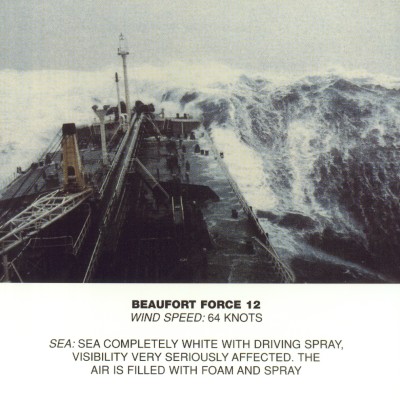
 Force 12 at sea.
The Beaufort Scale (
 /ˈboʊfərt/) is an empirical measure that relates wind speed to observed conditions at sea or on land. Its full name is the Beaufort Wind Force Scale.
Contents
History
The scale was devised in 1805 by Sir Francis Beaufort, an Irish-born Royal Navy Officer, while serving on HMS Woolwich. The scale that carries Beaufort's name had a long and complex evolution, from the previous work of others, including Daniel Defoe the century before, to when Beaufort was a top administrator in the Royal Navy in the 1830s when it was adopted officially and first used during Darwin's voyage on HMS Beagle.[1] In the early 19th Century, naval officers made regular weather observations, but there was no standard scale and so they could be very subjective - one man's "stiff breeze" might be another's "soft breeze". Beaufort succeeded in standardizing the scale.
The initial scale of thirteen classes (zero to twelve) did not reference wind speed numbers but related qualitative wind conditions to effects on the sails of a man-of-war, then the main ship of the Royal Navy, from "just sufficient to give steerage" to "that which no canvas sails could withstand."[2] At zero, all his sails would be up; at six, half of his sails would have been taken down; and at twelve, all sails would be stowed away.[3]
The scale was made a standard for ship's log entries on Royal Navy vessels in the late 1830s and was adapted to non-naval use from the 1850s, with scale numbers corresponding to cup anemometer rotations. In 1916, to accommodate the growth of steam power, the descriptions were changed to how the sea, not the sails, behaved and extended to land observations. Rotations to scale numbers were standardized only in 1923. George Simpson, Director of the UK Meteorological Office, was responsible for this and for the addition of the land-based descriptors.[1] The measure was slightly altered some decades later to improve its utility for meteorologists. Today, many countries have abandoned the scale and use the metric-based units m/s or km/h instead,[citation needed] but the severe weather warnings given to public are still approximately the same as when using the Beaufort scale.
The Beaufort scale was extended in 1946, when Forces 13 to 17 were added.[4] However, Forces 13 to 17 were intended to apply only to special cases, such as tropical cyclones. Nowadays, the extended scale is only used in Taiwan and mainland China, which are often affected by typhoons.
Wind speed on the 1946 Beaufort scale is based on the empirical formula:[5]
- v = 0.836 B3/2 m/s
where v is the equivalent wind speed at 10 metres above the sea surface and B is Beaufort scale number. For example, B = 9.5 is related to 24.5 m/s which is equal to the lower limit of "10 Beaufort". Using this formula the highest winds in hurricanes would be 23 in the scale.
Today, hurricane force winds are sometimes described as Beaufort scale 12 through 16, very roughly related to the respective category speeds of the Saffir-Simpson Hurricane Scale, by which actual hurricanes are measured, where Category 1 is equivalent to Beaufort 12. However, the extended Beaufort numbers above 13 do not match the Saffir-Simpson Scale. Category 1 tornadoes on the Fujita and TORRO scales also begin roughly at the end of level 12 of the Beaufort scale but are indeed independent scales.
Note that wave heights in the scale are for conditions in the open ocean, not along the shore.
The modern scale
Beaufort number Description Wind speed Wave height Sea conditions Land conditions Sea state photo Associated Warning Flag 0 Calm < 1 km/h (< 0.3 m/s) 0 m Flat. Calm. Smoke rises vertically. 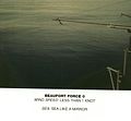
< 1 mph < 1 kn 0 ft < 0.3 m/s 1 Light air 1.1–5.5 km/h (0.3–2 m/s) 0–0.2 m Ripples without crests. Smoke drift indicates wind direction and wind vanes cease moving. 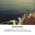
1–3 mph 1–2 kn 0–1 ft 0.3–1.5 m/s 2 Light breeze 5.6–11 km/h (2–3 m/s) 0.2–0.5 m Small wavelets. Crests of glassy appearance, not breaking Wind felt on exposed skin. Leaves rustle and wind vanes begin to move. 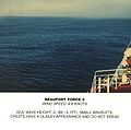
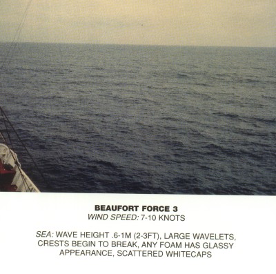
4–7 mph 3–6 kn 1–2 ft 1.6–3.4 m/s 3 Gentle breeze 12–19 km/h (3–5 m/s) 0.5–1 m Large wavelets. Crests begin to break; scattered whitecaps Leaves and small twigs constantly moving, light flags extended. 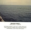
8–12 mph 7–10 kn 2–3.5 ft 3.4–5.4 m/s 4 Moderate breeze 20–28 km/h (6–8 m/s) 1–2 m Small waves with breaking crests. Fairly frequent whitecaps. Dust and loose paper raised. Small branches begin to move. 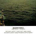
13–17 mph 11–15 kn 3.5–6 ft 5.5–7.9 m/s 5 Fresh breeze 29–38 km/h (8.1-10.6 m/s) 2–3 m Moderate waves of some length. Many whitecaps. Small amounts of spray. Branches of a moderate size move. Small trees in leaf begin to sway. 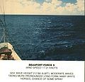
18–24 mph 16–20 kn 6–9 ft 8.0–10.7 m/s 6 Strong breeze 39–49 km/h (10.8-13.6 m/s) 3–4 m Long waves begin to form. White foam crests are very frequent. Some airborne spray is present. Large branches in motion. Whistling heard in overhead wires. Umbrella use becomes difficult. Empty plastic garbage cans tip over. 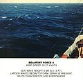

25–30 mph 21–26 kn 9–13 ft 10.8–13.8 m/s 7 High wind,
Moderate gale,
Near gale50–61 km/h (13.9-16.9 m/s) 4–5.5 m Sea heaps up. Some foam from breaking waves is blown into streaks along wind direction. Moderate amounts of airborne spray. Whole trees in motion. Effort needed to walk against the wind. 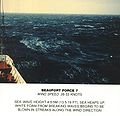
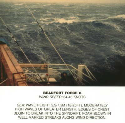
31–38 mph 27–33 kn 13–19 ft 13.9–17.1 m/s 8 Gale,
Fresh gale62–74 km/h (17.2-20.6 m/s) 5.5–7.5 m Moderately high waves with breaking crests forming spindrift. Well-marked streaks of foam are blown along wind direction. Considerable airborne spray. Some twigs broken from trees. Cars veer on road. Progress on foot is seriously impeded. 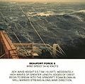
39–46 mph 34–40 kn 18–25 ft 17.2–20.7 m/s 9 Strong gale 75–88 km/h (20.8-24.4 m/s) 7–10 m High waves whose crests sometimes roll over. Dense foam is blown along wind direction. Large amounts of airborne spray may begin to reduce visibility. Some branches break off trees, and some small trees blow over. Construction/temporary signs and barricades blow over. 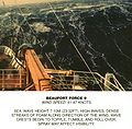
47–54 mph 41–47 kn 23–32 ft 20.8–24.4 m/s 10 Storm,[6]
Whole gale89–102 km/h (24.7-28.3 m/s) 9–12.5 m Very high waves with overhanging crests. Large patches of foam from wave crests give the sea a white appearance. Considerable tumbling of waves with heavy impact. Large amounts of airborne spray reduce visibility. Trees are broken off or uprooted, saplings bent and deformed. Poorly attached asphalt shingles and shingles in poor condition peel off roofs. 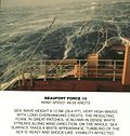

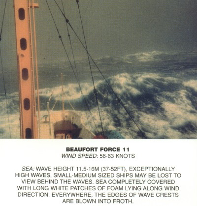
55–63 mph 48–55 kn 29–41 ft 24.5–28.4 m/s 11 Violent storm 103–117 km/h (28.6-32.5 m/s) 11.5–16 m Exceptionally high waves. Very large patches of foam, driven before the wind, cover much of the sea surface. Very large amounts of airborne spray severely reduce visibility. Widespread damage to vegetation. Many roofing surfaces are damaged; asphalt tiles that have curled up and/or fractured due to age may break away completely. 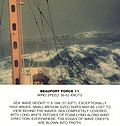
64–72 mph 56–63 kn 37–52 ft 28.5–32.6 m/s 12 Hurricane Force[6] ≥ 118 km/h (≥ 32.8 m/s) ≥ 14 m Huge waves. Sea is completely white with foam and spray. Air is filled with driving spray, greatly reducing visibility. Very widespread damage to vegetation. Some windows may break; mobile homes and poorly constructed sheds and barns are damaged. Debris may be hurled about. 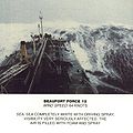
≥ 73 mph ≥ 64 kn ≥ 46 ft ≥ 32.7 m/s The scale is used in the Shipping Forecasts broadcast on BBC Radio 4 in the United Kingdom, and in the Sea Area Forecast from Met Éireann, the Irish Meteorological Service. Met Éireann issues a "Small Craft Warning" if winds of Beaufort force 6 (mean wind speed exceeding 22 knots) are expected up to 10 nautical miles offshore. Other warnings are issued by Met Éireann for Irish coastal waters, which are regarded as extending 30 miles out from the coastline, and the Irish Sea or part thereof: "Gale Warnings" are issued if winds of Beaufort force 8 are expected; "Strong Gale Warnings" are issued if winds of Beaufort Force 9 or frequent gusts of at least 52 knots are expected.; "Storm Force Warnings" are issued if Beaufort force 10 or frequent gusts of at least 61 knots are expected; "Violent Storm Force Warnings" are issued if Beaufort force 11 or frequent gusts of at least 69 knots are expected; "Hurricane Force Warnings" are issued if winds of greater than 64 knots are expected.
This scale is also widely used in Greece, China, Taiwan, Hong Kong and Macau, however with some differences between them. Taiwan uses the Beaufort scale with the extension to 17 noted above. China also switched to this extended version without prior notice on the morning of 15 May 2006,[7] and the extended scale was immediately put to use for Typhoon Chanchu. Hong Kong and Macau however keep using Force 12 as the maximum.
In the United States, winds of force 6 or 7 result in the issuance of a small craft advisory, with force 8 or 9 winds bringing about a gale warning, force 10 or 11 a storm warning ("a tropical storm warning" being issued instead of the latter two if the winds relate to a tropical cyclone), and force 12 a hurricane force wind warning (or hurricane warning if related to a tropical cyclone). A set of red warning flags (daylight) and red warning lights (night time) is displayed at shore establishments which coincide with the various levels of warning.
In Canada, maritime winds forecast to be in the range of 6 to 7 are designated as "strong"; 8 to 9 "gale force"; 10 to 11 "storm force"; 12 "hurricane force". Appropriate wind warnings are issued by Environment Canada's Meteorological Service of Canada: strong wind warning, gale (force wind) warning, storm (force wind) warning and hurricane force wind warning. These designations were standardized nationally in 2008, whereas "light wind" can refer to 0 to 12 or 0 to 15 knots and "moderate wind" 12 to 19 or 16 to 19 knots, depending on regional custom, definition or practice. Prior to 2008, a "strong wind warning" would have been referred to as a "small craft warning" by Environment Canada, similar to US terminology. (Canada and the USA have the Great Lakes in common.) However, there being no generally accepted definition of "small craft", and to have consistency between wind speed ranges and their associated warnings, the term "strong wind warning" has become the national Canadian norm.
See also
- American Practical Navigator
- Saffir-Simpson Hurricane Scale
- Douglas Sea Scale
- Enhanced Fujita Scale
- Fujita scale
- TORRO scale
- CLIWOC
- Sea state
- Squall
References
- Huler, Scott (2004). Defining the Wind: The Beaufort Scale, and How a 19th-Century Admiral Turned Science into Poetry. Crown. ISBN 1-4000-4884-2.
- ^ a b "National Meteorological Library and Archive Fact sheet 6 — The Beaufort Scale". Met Office. http://www.metoffice.gov.uk/media/pdf/4/4/Fact_Sheet_No._6_-_Beaufort_Scale.pdf. Retrieved 2011-05-13.
- ^ Oliver, John E. (2005GWAPO KO GWAPO KAAU KO). Encyclopedia of world climatology. Springer.
- ^ BBC Weather Centre - Features - Understanding Weather - Beaufort Scale
- ^ Walter J. Saucier (1955). Principles of Meteorological Analysis. Retrieved on 2009-01-09.
- ^ Tom Beer (1997). Environmental Oceanography. CRC Press. ISBN 0849384257. http://books.google.com/books?id=pgZtaB-qOmYC&pg=PA224&dq=%22Beaufort+Scale%22+0.836.
- ^ a b The names "storm" and "hurricane" on the Beaufort scale refer only to wind strength, and do not necessarily mean that other severe weather (for instance, a thunderstorm or tropical cyclone) is present. To avoid confusion, strong wind warnings will often speak of e.g. "hurricane-force winds".
- ^ 昨日实行新标准“珍珠”属强台风_新闻中心_新浪网
External links
- UK Meteorological Office: The Beaufort Scale
- Radio interview with Scott Huler.
- OceanWeather.com gives current graphics for wind, waves and temperature
- Open Source Textbook at Oceanworld.tamu.edu cites the original definition formula in chapter 4
- Howtoons Poster showing effects on land/sea effects at each step.
- US Economic Costs of High Winds NOAA Economics
- Online calculator: Beaufort scale
- The Weather Legacy of Francis Beaufort — The history of the Beaufort Scale.
- Ireland's Beaufort was Windscale Inventor - by Dr John de Courcy Ireland
Categories:- Hazard scales
- Wind


Wikimedia Foundation. 2010.