- Danube-Auen National Park
-
Danube-Auen National Park IUCN Category II (National Park)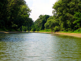
Danube-Auen near Hainburg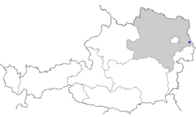
Location Vienna and Lower Austria Nearest city Vienna Coordinates 48°8′0″N 16°55′0″E / 48.133333°N 16.916667°ECoordinates: 48°8′0″N 16°55′0″E / 48.133333°N 16.916667°E Area 93 km² Established October 27, 1996 The Danube-Auen National Park (German: Nationalpark Donau-Auen) covers 93 square kilometres in Vienna and Lower Austria and is one of the largest remaining floodplains of the Danube in Middle Europe.
The park was designated an IUCN category II national park and spans the areas of Vienna (Lobau), Groß-Enzersdorf, Orth an der Donau, Eckartsau, Engelhartstetten, Hainburg, Bad Deutsch-Altenburg, Petronell-Carnuntum, Regelsbrunn, Haslau-Maria Ellend, Fischamend and Schwechat.
External links
- www.donauauen.at (English)(German)
National parks of Austria - IUCN V category (protected landscape)
Categories:- IUCN Category II
- National parks of Austria
- Protected areas established in 1996
- Gänserndorf District
- Donaustadt
- Schwechat
- Bruck an der Leitha District
- Parks in Vienna
- Austria geography stubs
- Lower Austria geography stubs


Wikimedia Foundation. 2010.