- Mickleover railway station
-
Mickleover 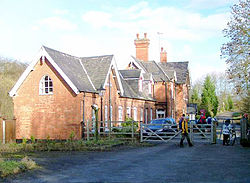
Station building in 2004. Location Place Mickleover Area Derby Operations Original company Great Northern Railway Post-grouping London and North Eastern Railway
London Midland Region of British RailwaysPlatforms ? History 1 April 1878[1] Opened 4 December 1939 Closed to passengers 3 February 1964[2] Goods facilities withdrawn Disused railway stations in the United Kingdom Closed railway stations in Britain
A B C D–F G H–J K–L M–O P–R S T–V W–ZMickleover railway station was a railway station serving the village of Mickleover, Derbyshire, England (now part of the city of Derby). It was opened by the Great Northern Railway on its Derbyshire Extension in 1878.
History
From Derby Friargate the line climbed at 1 in 100 for two miles southwards. On the outskirts shortly after the present Derby ring road the line entered a deep cutting leading to Mickleover Tunnel. The summit of the climb lay at the other end and, being curved, it presented a particular challenge to train drivers.
The station was about a mile north of the village along Station Road. It was labelled Mickleover for Radbourne, since it was in that parish, albeit some two miles distant. Originally it was spelt "Radburn" and, for a while, "Radbourn".
It was provided with substantial brick buildings; a two-storey station master's house and the usual single storey offices on the platforms. Regular passenger traffic finished in 1939, although it saw excursions until 1959, until complete closure in 1964.
The line from Friargate remained open for some years, being used as a test track by the British Rail Research Division.
Preceding station Disused railways Following station Derby Friargate London Midland Region of British Railways
(Derby) Friargate LineEtwall Present day
The main station building has been converted into two private dwellings.[3]
References
- ^ Butt, R.V.J. (1995). The Directory of Railway Stations, Patrick Stephens Ltd, Sparkford, ISBN 1-85260-508-1, p. 158.
- ^ Clinker, C.R. (October 1978). Clinker's Register of Closed Passenger Stations and Goods Depots in England, Scotland and Wales 1830-1977. Bristol: Avon-AngliA Publications & Services. p. 46. ISBN 0-90546-619-5.
- ^ Higginson, M., (1989) The Friargate Line:Derby and the Great Northern Railway, Derby: Golden Pingle Publishing
Categories:- Disused railway stations in Derbyshire
- Railway stations in Derby
- Railway stations opened in 1878
- Railway stations closed in 1964
- Former Great Northern Railway stations

Wikimedia Foundation. 2010.