- National Register of Historic Places listings in Eau Claire County, Wisconsin
-
Buildings, sites, structures, districts, and objects in Eau Claire County listed on the National Register of Historic Places
This document is intended to provide a comprehensive listing of entries in the National Register of Historic Places that are located in Eau Claire County, Wisconsin. The locations of National Register properties, the latitude and longitude coordinates of which are included below, may be seen in a Google map.[1]
-
- This National Park Service list is complete through NPS recent listings posted November 10, 2011.[2]
Current listings
[3] Landmark name Image Date listed Location City or town Summary 1 Brady Anderson and Waldemar Ager House March 16, 2000 514 W. Madison St.
44°48′57″N 91°30′50″W / 44.815833°N 91.513889°WEau Claire 2 James Barber House January 28, 1983 132 Marston Ave.
44°48′15″N 91°29′45″W / 44.804167°N 91.495833°WEau Claire 3 Barnes Block January 22, 1982 15-21 S. Barstow St.
44°48′46″N 91°30′04″W / 44.812778°N 91.501111°WEau Claire 4 Martin Van Buren Barron House January 28, 1983 221 Washington St.
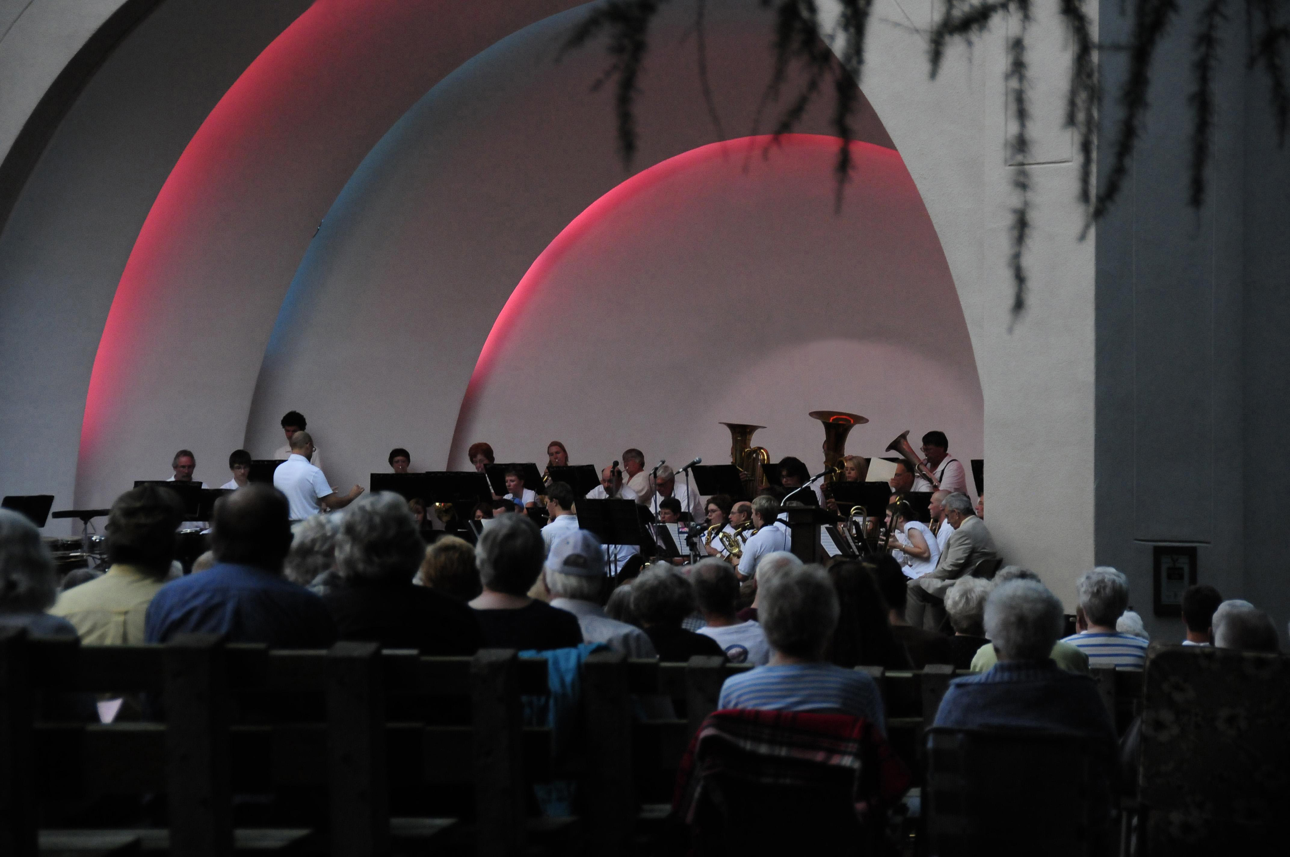
44°48′15″N 91°29′33″W / 44.804167°N 91.4925°WEau Claire 5 Sarge Boyd Bandshell 
September 2, 2003 First Ave., Owen Park
44°48′19″N 91°29′58″W / 44.805278°N 91.499444°WEau Claire Designed by Alex Garnock and built in 1938 by the WPA to accommodate the popularity of the Eau Claire Municipal Band, the bandshell was dedicated in 1992 to Donald I. "Sarge" Boyd in recognition of the profound influence his half century of musical leadership had on the cultural development of the Chippewa Valley. 6 Orlando Brice House January 28, 1983 120 Marston Ave.
44°48′14″N 91°29′47″W / 44.803889°N 91.496389°WEau Claire 7 California Wine and Liquor Store March 1, 1982 201 Farmers St.
44°36′03″N 90°57′55″W / 44.600833°N 90.965278°WFairchild 8 Carson Park Baseball Stadium 
July 25, 2003 Carson Park Dr., Carson Park
44°48′26″N 91°31′14″W / 44.807222°N 91.520556°WEau Claire 9 Clarence Chamberlin House January 27, 2000 322 W. Grand Ave.
44°48′31″N 91°30′22″W / 44.808611°N 91.506111°WEau Claire 10 Chicago, St. Paul, Minneapolis & Omaha Railroad Depot October 24, 1985 324 Putnam Ave.
44°49′00″N 91°29′47″W / 44.816667°N 91.496389°WEau Claire 11 Christ Church Cathedral and Parish House 
January 28, 1983 510 S. Farwell St.
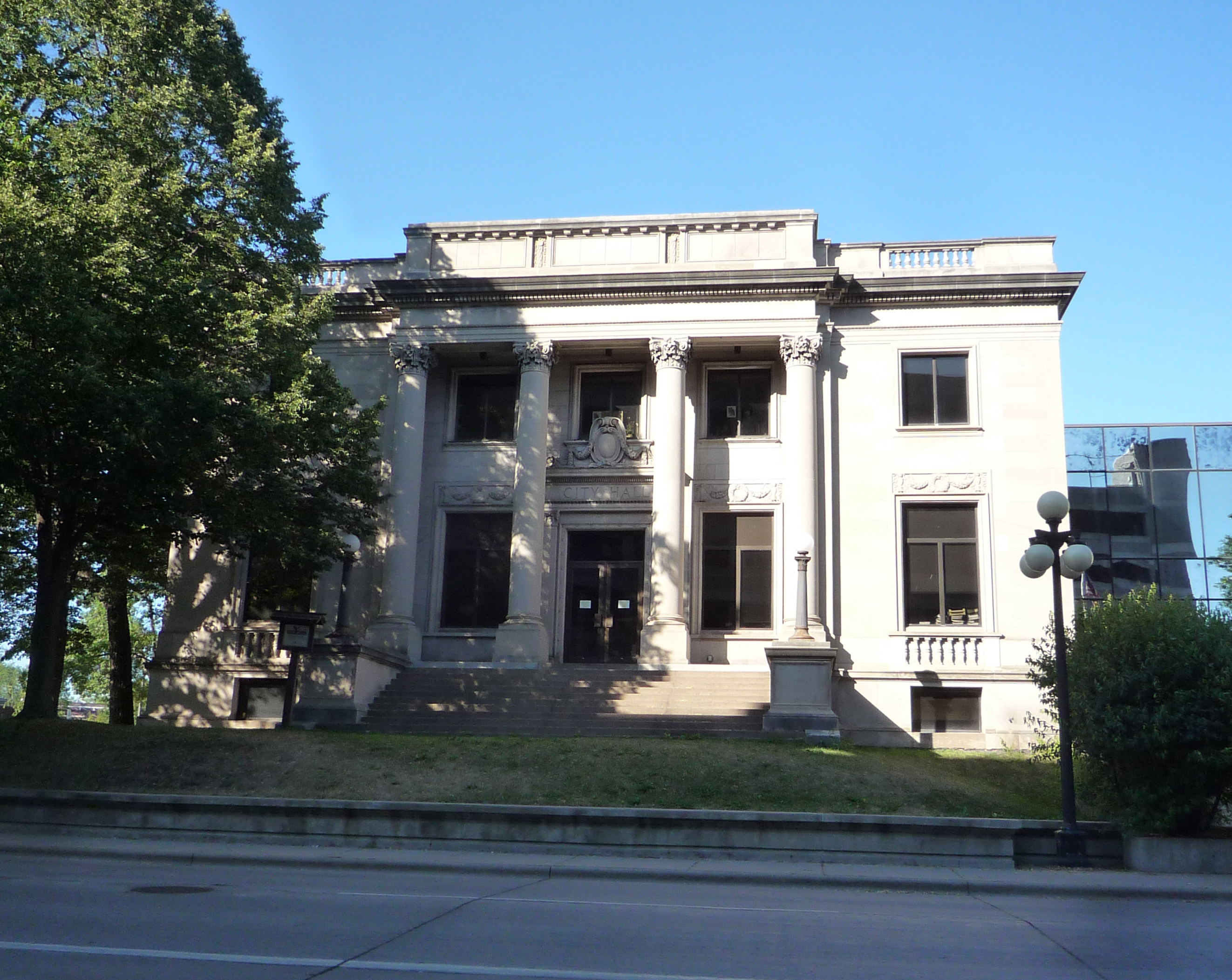
44°48′33″N 91°29′48″W / 44.809167°N 91.496667°WEau Claire 12 City Hall 
January 28, 1983 203 S. Farwell St.
44°48′44″N 91°29′54″W / 44.812222°N 91.498333°WEau Claire 13 Cobblestone House November 19, 1974 1011 State St.
44°48′18″N 91°29′38″W / 44.805°N 91.493889°WEau Claire 1866 house with exterior of local cobblestones constructed in Gothic Revival style.[4][5] 14 Community House, First Congregational Church July 18, 1974 310 Broadway
44°48′19″N 91°30′22″W / 44.805278°N 91.506111°WEau Claire 15 Confluence Commercial Historic District October 3, 2007 2-28 S Barstow; 206-316 Eau Claire & 8 S Farwell Sts.
44°48′46″N 91°30′04″W / 44.812772°N 91.500975°WEau Claire Historic point of origin of city of Eau Claire, with buildings from 1861 to 1936.[6] 16 Dells Mill 
December 24, 1974 About 3 mi. NNW of Augusta off WI 27
44°43′32″N 91°08′54″W / 44.725556°N 91.148333°WAugusta The gristmill on Bridge Creek was built in 1864, when wheat was the cash crop in this part of Wisconsin.[7] 17 Drummond Business Block October 10, 2007 409-417 Galloway St.
44°48′54″N 91°30′05″W / 44.815°N 91.501389°WEau Claire Built from 1879 to 1884, the buildings housed a meat-packing company, a wholesale grocer, and later the Farmers Store.[8] 18 David Drummond House July 30, 1974 1310 State St.
44°48′05″N 91°29′44″W / 44.801389°N 91.495556°WEau Claire 19 Eau Claire High School January 28, 1983 314 Doty St.
44°48′43″N 91°29′47″W / 44.811944°N 91.496389°WEau Claire 20 Eau Claire Masonic Temple 
November 14, 2007 317-319 S Barstow & 306 Main Sts.
44°48′37″N 91°29′54″W / 44.810278°N 91.498333°WEau Claire Built in 1899,[9] the former (1899-1927) Eau Claire Masonic Temple is now the Antique Emporium. 21 Eau Claire Park Company Addition Historic District September 10, 2004 Roosevelt, McKinley, and Garfield between Park Ave. and State St.
44°47′51″N 91°29′47″W / 44.7975°N 91.496389°WEau Claire 22 Eau Claire Public Library January 28, 1983 217 S. Farwell St.
44°48′43″N 91°29′53″W / 44.811944°N 91.498056°WEau Claire 23 Christine Eichert House January 28, 1983 527 N. Barstow St.
44°49′09″N 91°31′37″W / 44.819167°N 91.526944°WEau Claire 24 Emery Street Bungalow District May 20, 1983 Emery St. between Chauncey and Agnes Sts.
44°48′39″N 91°28′47″W / 44.810833°N 91.479722°WEau Claire Modest homes built between 1915 and 1930.[10] 25 First Methodist Episcopal Church February 18, 1999 421 S. Farwell St.
44°48′37″N 91°29′48″W / 44.810278°N 91.496667°WEau Claire 26 Gilbert Gikling House January 16, 2001 421 Talmadge St.
44°48′43″N 91°29′31″W / 44.811944°N 91.491944°WEau Claire 27 James Stephen Hoover and Elizabeth Borland Memorial Chapel January 7, 2000 Lakeview Cemetery, Buffington Dr.
44°48′44″N 91°31′28″W / 44.812222°N 91.524444°WEau Claire 28 John Johnson Saloon January 28, 1983 216 Fifth Ave.
44°48′10″N 91°30′35″W / 44.802778°N 91.509722°WEau Claire 29 Kaiser Lumber Company Office January 28, 1983 1004 Menomonie St.
44°48′05″N 91°31′12″W / 44.801389°N 91.52°WEau Claire 30 A. L. Kenyon House January 28, 1983 333 Garfield Ave.
44°47′54″N 91°29′34″W / 44.798333°N 91.492778°WEau Claire 31 Kline's Department Store June 14, 1984 6-10 S. Barstow St.
44°48′46″N 91°30′02″W / 44.812778°N 91.500556°WEau Claire 32 Levi Merrill House June 20, 1985 120 Ferry St.
44°47′54″N 91°32′05″W / 44.798333°N 91.534722°WEau Claire 33 Oatman Filling Station January 16, 2001 102 Ferry St.
44°47′56″N 91°32′05″W / 44.798889°N 91.534722°WEau Claire This 1931 house-type gas station was designed to blend into its suburban neighborhood.[11] 34 Ottawa House January 28, 1983 602 Water St.
44°48′08″N 91°30′42″W / 44.802222°N 91.511667°WEau Claire 35 John S. Owen House January 28, 1983 907 Porter Ave.
44°48′20″N 91°29′46″W / 44.805556°N 91.496111°WEau Claire 36 Pioneer Block August 27, 1980 401-409 Water St.
44°48′07″N 91°30′28″W / 44.801944°N 91.507778°WEau Claire 37 Jane E. Putnam Memorial Chapel January 7, 2000 Forest Hill Cemetery, Emery St.
44°48′31″N 91°29′17″W / 44.808611°N 91.488056°WEau Claire 38 Randall Park Historic District May 20, 1983 Roughly bounded by Lake and Niagara Sts., 3rd and 5th Aves.
44°48′18″N 91°30′23″W / 44.805°N 91.506389°WEau Claire 39 Adin Randall House January 28, 1983 526 Menomonie St.
44°48′05″N 91°30′38″W / 44.801389°N 91.510556°WEau Claire 40 Roosevelt Avenue Historic District April 15, 2009 415,419,429,443,449 & 455 Roosevelt Ave.
44°47′48″N 91°29′31″W / 44.796561°N 91.491994°WEau Claire 41 Sacred Heart Church March 3, 1983 418 N. Dewey St.
44°49′05″N 91°29′59″W / 44.818056°N 91.499722°WEau Claire 42 Saint Edward's Chapel January 7, 2000 1129 Bellevue Ave.
44°49′01″N 91°29′29″W / 44.816944°N 91.491389°WEau Claire 43 Salsbury Row House April 15, 2009 302-310 W. Grand Ave.
44°48′31″N 91°30′19″W / 44.808703°N 91.505239°WEau Claire 44 Schofield Hall January 28, 1983 105 Garfield Ave.
44°47′55″N 91°30′00″W / 44.798611°N 91.5°WEau Claire 45 William and Tilla Schwahn House January 16, 2001 447 McKinley Ave.
44°47′49″N 91°29′28″W / 44.796944°N 91.491111°WEau Claire 46 Second Ward School January 7, 2000 1105 Main St.
44°48′43″N 91°29′10″W / 44.811944°N 91.486111°WEau Claire 47 Soo Line Locomotive 2719 
January 10, 1994 Carson Park
44°48′25″N 91°31′14″W / 44.806944°N 91.520556°WEau Claire Locomotive moved in 2006 to the Lake Superior Railroad Museum in Duluth, Minnesota 48 St. Joseph's Chapel January 14, 1988 Sacred Heart Cemetery, Omaha St.
44°49′27″N 91°28′50″W / 44.824167°N 91.480556°WEau Claire 49 St. Patrick's Church January 28, 1983 322 Fulton St
44°48′41″N 91°30′30″W / 44.811389°N 91.508333°WEau Claire 50 Steven House March 1, 1982 606 Second Ave.
44°48′22″N 91°30′13″W / 44.806111°N 91.503611°WEau Claire 51 Temple of Free Masonry 
January 14, 1988 616 Graham Ave.
44°48′27″N 91°29′53″W / 44.8075°N 91.498056°WEau Claire Built in 1927, the primary purpose of the Temple of Free Masonry, better known as the Masonic Center or Temple, has been to provide meeting space for the area's Masonic organizations. Since the mid-1990s, it has also served as the rain/rehearsal site for the Eau Claire Municipal Band. 52 Third Ward Historic District May 20, 1983 Roughly bounded by Chippewa River, Park Pl., Gilbert Ave., and Farwell St.
44°48′02″N 91°29′38″W / 44.800556°N 91.493889°WEau Claire Boundary increase (listed September 10, 2004): Approximately seven blks in the Third Ward bounded by State St., Summit Ave., Farwell St. and Garfield Ave. 53 Union Auto Company October 11, 2007 505 S. Barstow St.
44°48′34″N 91°29′51″W / 44.809444°N 91.4975°WEau Claire 54 Union National Bank January 28, 1983 131 S. Barstow St.
44°48′43″N 91°30′00″W / 44.811944°N 91.5°WEau Claire 55 US Post Office and Courthouse 
July 25, 1991 500 S. Barstow Commons
44°48′32″N 91°29′54″W / 44.808889°N 91.498333°WEau Claire 56 Walter-Heins House March 19, 1982 605 N. Barstow St.
44°49′08″N 91°30′08″W / 44.818889°N 91.502222°WEau Claire 57 Water Street Historic District October 11, 2007 402-436 & 401-421 Water St.
44°48′07″N 91°30′28″W / 44.801944°N 91.507778°WEau Claire 58 Dr. Nels Werner House January 16, 2001 443 Roosevelt Ave.
44°47′48″N 91°29′27″W / 44.796667°N 91.490833°WEau Claire 59 Roy Wilcox House January 28, 1983 104 Wilcox St
44°48′16″N 91°29′49″W / 44.804444°N 91.496944°WEau Claire 60 George F. Winslow House December 8, 1978 210 Oakwood Pl.
44°48′07″N 91°29′45″W / 44.801944°N 91.495833°WEau Claire Designed by architect George Franklin Barber See also
References
- ^ The latitude and longitude information provided is primarily from the National Register Information System, and has been found to be fairly accurate for about 99% of listings. For 1%, the location info may be way off. We seek to correct the coordinate information wherever it is found to be erroneous. Please leave a note in the Discussion page for this article if you believe any specific location is incorrect.
- ^ "National Register of Historic Places: Weekly List Actions". National Park Service, United States Department of the Interior. Retrieved on November 10, 2011.
- ^ Numbers represent an ordering by significant words. Various colorings, defined here, differentiate National Historic Landmark sites and National Register of Historic Places Districts from other NRHP buildings, structures, sites or objects.
- ^ "cobblestone (architecture)". Dictionary of Wisconsin History. Wisconsin Historical Society. http://www.wisconsinhistory.org/dictionary/index.asp?action=view&term_id=9279&term_type_id=3&term_type_text=Things&letter=C.
- ^ "The Cobblestone House". Historical Marker Database. http://www.hmdb.org/marker.asp?marker=31155. Retrieved 2011-11-10.
- ^ "Confluence Commercial Historic District - Wisconsin National Register of Historic Places". Wisconsin Historic Society. http://www.wisconsinhistory.org/hp/register/viewSummary.asp?refnum=07001047. Retrieved 2011-05-12.
- ^ "Dells Mill Sixty-Five Years Old". Augusta Union. 1929-11-29. http://www.augustawi.com/history-new/augusta-wi-history-dells-mill-03.html. Retrieved 2011-07-09.
- ^ "Drummond Business Block - Wisconsin National Register of Historic Places". Wisconsin Historical Society. http://www.wisconsinhistory.org/hp/register/viewSummary.asp?refnum=07001084. Retrieved 2011-05-12.
- ^ "Eau Claire Masonic Temple - Wisconsin National Register of Historic Places". Wisconsin Historical Society. http://www.wisconsinhistory.org/hp/register/viewSummary.asp?refnum=07001197. Retrieved 2011-05-12.
- ^ "Emery Street Bungalow District - Wisconsin National Register of Historic Places". Wisconsin Historical Society. http://www.wisconsinhistory.org/hp/register/viewSummary.asp?refnum=83003382. Retrieved 2011-05-12.
- ^ "Oatman Filling Station - Wisconsin National Register of Historic Places". Wisconsin Historical Society. http://www.wisconsinhistory.org/hp/register/viewSummary.asp?refnum=00001669. Retrieved 2011-05-12.
U.S. National Register of Historic Places Topics Lists by states Alabama • Alaska • Arizona • Arkansas • California • Colorado • Connecticut • Delaware • Florida • Georgia • Hawaii • Idaho • Illinois • Indiana • Iowa • Kansas • Kentucky • Louisiana • Maine • Maryland • Massachusetts • Michigan • Minnesota • Mississippi • Missouri • Montana • Nebraska • Nevada • New Hampshire • New Jersey • New Mexico • New York • North Carolina • North Dakota • Ohio • Oklahoma • Oregon • Pennsylvania • Rhode Island • South Carolina • South Dakota • Tennessee • Texas • Utah • Vermont • Virginia • Washington • West Virginia • Wisconsin • WyomingLists by territories Lists by associated states Other Municipalities and communities of Eau Claire County, Wisconsin Cities Altoona | Augusta | Eau Claire‡

Villages Towns Bridge Creek | Brunswick | Clear Creek | Drammen | Fairchild | Lincoln | Ludington | Otter Creek | Pleasant Valley | Seymour | Union | Washington | Wilson
CDP Unincorporated
communitiesAllen | Brackett | Cleghorn | Foster | Hadleyville | Hale Corner | Hay Creek | Ludington | Lufkin | Mount Hope Corners | Rodell | Truax | Union | Wilson
Ghost towns Nelsonville | Oak Grove | Porter's Mills
Footnotes ‡This populated place also has portions in an adjacent county or counties
Categories:- Eau Claire County, Wisconsin
- Lists of historic places in Wisconsin
-


Wikimedia Foundation. 2010.