- Munshiganj District
-
Munshiganj
মুন্সীগঞ্জ Bikrampur— District — Dhaleshwari River bank, Munshiganj Sadar Upazila in Munsiganj District Location of Munshiganj in Bangladesh
Coordinates: 23°28′N 90°32′E / 23.46°N 90.54°ECoordinates: 23°28′N 90°32′E / 23.46°N 90.54°E Country  Bangladesh
Division Dhaka Division Area – Total 954.96 km2 (368.7 sq mi) Population (2011) – Total 1,420,000 – Density 1,487/km2 (3,851.2/sq mi) Literacy rate – Total 35.8% Time zone BST (UTC+6) – Summer (DST) BDST (UTC+7) Website Banglapedia Article Munshiganj (Bangla: মুন্সীগঞ্জ) also historically known as Bikrampur is a district[1] in central Bangladesh. It is a part of the Dhaka Division and borders Dhaka District.
Contents
Geography
Total land area is 235974 acres (954 km²), out of which 138472 acres (560 km²) are cultivable and 5609 acres (23 km²) are fallow land. It has no forest area. 40277 acres (163 km²) of land is irrigated while 26242 acres (106 km²) of land is under river. It has 14 rivers of 155 km passing through.[2]
Subdivisions
The district consists of 6 upazilas:
- Lohajang Upazila
- Sreenagar Upazila
- Munshiganj Sadar Upazila
- Sirajdikhan Upazila
- Tongibari Upazila
- Gazaria Upazila
Economy
Munshiganj is one of the largest producer of potato in Bangladesh. It produces significant amount of jute, rice, wheat and other vegetables. It also produces sugar cane and banana.
History
Bikrampur (Munshiganj) was the political and cultural centre of ancient Bengal. It was officially known as Bikrampur until 1986 and was part of Dhaka District. The remains of the city of Bikrampur, the capital of the ancient kingdoms of southeastern Bengal, are lost and its location can only be guessed on the basis of available data. Bangla, Old History
It was the capital city of the Candra, Varman and Sena dynasties, from the beginning of the 10th century AD to the beginning of the 13th century AD.
The name of Bikramapur survived in the name of a pargana in the Mughal period. Today the name does not exist even officially; but the inhabitants of a vast tract of land in the Munshigonj district still feel pride in saying that they belong to Bikramapur, which, of course, emanates from the past glory of the area. Also, within the confines of Munshigonj, the colonial era mansion of Badrul Islam, the renowned Kombal merchant, is located. Today it is a sacred site for Tibetan Buddhists.
Religion
The district of Munshiganj consist 3254 mosques, 348 temples, nine Buddhist temples and a church here.
Places of interest
Louhajong: Archaeological heritage are still found all around Louhajong, Bikrampur, although a large number of these sites is now being missed due to erosion of river Padma. The following is a summary of heritage that is worth visiting.
Munshigonj town: Idrakpur Fort (1660), Panditer vita (birth place of Atisha Dipankar Srijnan) at Bajrayogini, Baba Adam's Mosque, Dighi of Raja Harish Chandra, home stead of Raja Ballal Sena, home stead of Raja Sreenath at Rampal, Rampal Dighi, Kodal Dhoar Dighi, marble statue of Ashutosh Ganguly inside the library room of Haraganga College, Muktarpur bridge (The sixth Bangladesh-China friendship bridge over the river Dhaleswari connects the link between Dhaka and Munshigonj).
Sreenagar: Shyamsiddhi Math, Hasara Dargah, Sholaghar Math, Bhagyakul Rajbari, residence of Jagadis Chandra Basu at Rarikhal, Jora Math at Sonarang,
Tongibari: Kalibari, Taltala Pancha-shikhara Mahadeva Temple, Talukdarbari Mosque at Kusumpur, Tajpur Mosque, Patharghata Mosque, Kazishal Mosque, Pulghata Bridge, Panch Pir Dargah,
Sirajdikhan: A single domed mosque at Kusumpur (Talukdar-bari Mosque, Mughal period), Tajpur Mosque,kazirbag,buyan bhari, baytul mam'ur jamea mosque, Patharghata Mosque, Qazishal Mosque, Pulghata Bridge, math at village Fegnasar, math at the house of Kankata De at village Tajpur and Panchasikhar Mahadeva Mandir (temple) at Taltala. A large shiva-linga (phallus of god Shiva) is placed inside this temple.
Notable residents
Famous people from the district include:
- M. Hamidullah Khan, Bangladesh Forces Sector Commander, Sector 11, Bangladesh War of Independence 1971[3]
- Jagadish Chandra Bose, Great Bengali physicist[4]
- Fakhruddin Ahmed, Former Chief Adviser, Non-Party Caretaker Government of Bangladesh, 2007-2008.[5]
- Iajuddin Ahmed, Former President of Bangladesh
- Nurul Haque Chowdhury, Great Social Worker, renown Jomider during British ruling period.
- Atisa Dipankara Shrijnana, Buddhist teacher who reintroduced Buddhism to Tibet
- Humayun Azad, a linguistic scientist, poet and novelist [6]
- A.Q.M. Badruddoza Chowdhury, Former President of Bangladesh
- Badal Gupta, revolutionary against British India
- A. R. Khandakar, former Inspector General of Police, freedom fighter, Ekushey Padak recipient
- Benoy Basu, revolutionary against British India
- Brojen Das, the first Bangladeshi and Asian to swim across the English Channel, and the first person to cross it four times
- Dhir Ali miya,A great music director,reformer of Bangladeshi modern folk songs & also a leader of dhaka orchestra
- Dinesh Gupta, revolutionary against British India
- Durga Mohan Das, Brahmo reformer
- Dwarkanath Ganguly, Brahmo reformer
- M. A. Naser, Pioneer in Engineering Education, former Vice Chancellor or BUET, Ekushey Padak recipient
- Emdadul Huq Milon, Writer & Media personality
- Saleh Uddin Ahmed, Former governor Bangladesh Bank
- M A Khaleq, Educationalist,Poet & Writer
- Fariaz Morshed Chowdhury, Hotelier, Writer, Social Worker, Trainer, Tours & Travel Specialist
- Sreya Ghoshal, Famous Indian Singer
See also
References
 Divisions and districts of Bangladesh
Barisal Division 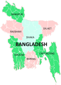
Chittagong Division Bandarban · Brahmanbaria · Chandpur · Chittagong · Comilla · Cox's Bazar · Feni · Khagrachari · Lakshmipur · Noakhali · RangamatiDhaka Division Dhaka · Faridpur · Gazipur · Gopalganj · Jamalpur · Kishoreganj · Madaripur · Manikgonj · Munshiganj · Mymensingh · Narayanganj · Narsingdi · Netrokona · Rajbari · Shariatpur · Sherpur · TangailKhulna Division Rajshahi Division Rangpur Division Sylhet Division Categories:


Wikimedia Foundation. 2010.