- New Jersey Route 62
-
Route 62
Union Boulevard Route information Maintained by NJDOT Length: 0.47 mi[1] (0.76 km) Existed: 1953 (1929 as S6) – present Major junctions South end:  US 46 in Totowa
North end:  I-80 in Totowa
Highway system New Jersey State Highway Routes
Interstate and US←  Route 60
Route 63  →
→Route 62 is a 0.47-mile (0.76 km) long state highway in the U.S. state of New Jersey. It begins at the centerline of U.S. Route 46 along Union Boulevard (Passaic County Route 646) in the community of Totowa and continues northward to the merge of the Interstate 80 westbound off-ramp at Exit 55B, where Route 62 ends. The route continues as Passaic County Route 646 in both directions, heading northbound to Paterson and southbound to Little Falls.
Route 62 was originally an alignment of Route S6, which was designated in 1929. The route went from the Caldwells in Essex County to the West Paterson corporate line. Route S6 was decommissioned in the 1953 renumbering and replaced with Route 62, which went from Totowa to West Paterson until being truncated to its current length.
Contents
Route description
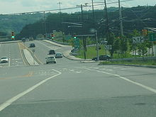 Route 62 southbound approaching the U.S. Route 46 interchange in Totowa
Route 62 begins at an intersection with the off-ramp from U.S. Route 46 eastbound and Passaic County Route 646 in the community of Totowa. The highway heads northward along Union Boulevard, intersecting with the on-ramp from Route 62 to U.S. Route 46 eastbound. The route heads across a long bridge over the eastbound and westbound divided lanes of Route 46. After crossing the bridge, Route 62 heads into a small industrial part of Totowa, where it intersects with the off-ramp from the westbound lanes of Route 46. The highway continues northward, interchanging with Furler Street and Lackawanna Avenue on a partial cloverleaf. Route 62 continues along Union Boulevard, becoming a divided highway. The highway crosses over Interstate 80 at interchange 55A, where the route's designation terminates.[2] The route continues into Paterson as County Route 646.[1]
History
 Route S6 (1927-1953)
Route 62 was designated in 1929 originally an alignment of State Highway Route S6, a spur off of Route 6 (currently U.S. Route 46). Route S6 went to the south from current Route 62 from Paterson into Totowa and along County Route 646 towards Little Falls, terminating at Bloomfield Avenue (old Route 6) near the Pine Brook Bridge in the Caldwells.[3] In the 1953 New Jersey state highway renumbering on January 1, 1953, Route S6 was truncated to U.S. Route 46 and renumbered to Route 62.[4][5] Route 62 remained a route heading northbound from Totowa to Paterson following Union Boulevard, Totowa Avenue and McBride Avenue, ending at the Paterson-West Paterson (now Woodland Park) town line for several years, constituting a length of 2.32 miles (3.73 km).[6] Route 62 remained along this alignment before being truncated by 1980.[7] Route 62 was left out of the Straight Line Diagrams produced by the New Jersey Department of Transportation in 2000,[8] but was returned the next year.[9] Route 62 received improvements of the interchange with Route 46 in 2006 at a cost of $22.748 million (2006 USD) to repair the bridge over Route 46, ramp reconfigurations and new resurfaced roadway.[10]
Major intersections
The entire route is in Totowa, Passaic County.
Mile[1] Destinations Notes 0.00 US 46Continues southward to Little Falls as County Route 646. 0.47 I-80Interchange 55A (I-80); Continues northward to Paterson as County Route 646. 1.000 mi = 1.609 km; 1.000 km = 0.621 mi See also
 U.S. Roads portal
 New Jersey portal
References
- ^ a b c "Route 62 Straight Line Diagram". New Jersey Department of Transportation. 2009. pp. 1. http://www.state.nj.us/transportation/refdata/sldiag/00000062__-.pdf. Retrieved August 26, 2009.
- ^ Microsoft Inc. (2009). Bing Maps - Overview map of Route 62 (Map). http://www.bing.com/maps/?FORM=Z9LH11#JnJ0cD1wb3MucXRmdDI5OHRkenYwX25lYXIrVW5pb24rQmx2ZCslMjZhbXAlM2IrUmFtcCUyYytUb3Rvd2ElMmMrTmV3K0plcnNleSswNzUxMiUyYytVbml0ZWQrU3RhdGVzX19fZV8lN2Vwb3MucXRnbjA2OHRmYnJyX25lYXIrVW5pb24rQmx2ZCUyYytUb3Rvd2ElMmMrTmV3K0plcnNleSswNzUxMiUyYytVbml0ZWQrU3RhdGVzX19fZV8mcnRvcD0wJTdlMA==. Retrieved August 24, 2009.
- ^ ROUTE NO. S-6. Beginning in the city of Paterson, extending in a southwesterly direction by way of Totowa, Little Falls Station on D. L. and W. railroad, and connecting with Route No. 6 in the vicinity of Caldwell township. New Jersey State Assembly. 1929.
- ^ 1953 renumbering. New Jersey Department of Highways. http://en.wikisource.org/wiki/1953_New_Jersey_state_highway_renumbering. Retrieved July 31, 2009.
- ^ "New Road Signs Ready in New Jersey". The New York Times. December 16, 1952. http://img123.imageshack.us/img123/6933/19521216newroadsignsreaiu6.jpg. Retrieved 2009-07-20.
- ^ Milepost Log of State Highways (1969 ed.). New Jersey State Highway Department. 1969.
- ^ Route 62 Straight Line Diagram (1980 ed.). New Jersey Department of Transportation. 1980.
- ^ Route 62 Straight Line Diagram (2000 ed.). New Jersey Department of Transportation. 2000.
- ^ Route 62 Straight Line Diagram (2001 ed.). New Jersey Department of Transportation. 2001.
- ^ "Fiscal Year 2004-2006 Statewide Transportation Improvement Program". New Jersey Department of Transportation. 2004. pp. 1. http://www.state.nj.us/transportation/capital/stip04-06/Route/Rt62.pdf. Retrieved August 26, 2009.
External links
- Moraeski, Dan (2009). "62". Alps Roads. http://www.alpsroads.net/roads/nj/log/6.html#62. Retrieved August 24, 2009.
- "Speed Limits for State Roads: Route 62". New Jersey Department of Transportation. 2009. http://www.state.nj.us/transportation/refdata/traffic_orders/speed/rt62.shtm. Retrieved August 24, 2009.
Categories:- State highways in New Jersey
- Transportation in Passaic County, New Jersey


Wikimedia Foundation. 2010.