- New Jersey Route 64
-
Route 64
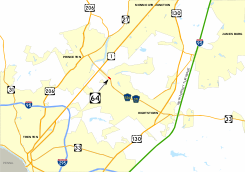
Route information Maintained by New Jersey Department of Transportation Length: 0.32 mi[2] (0.51 km) Existed: 1953 (Constructed in 1939)[1] – present Major junctions South end: 

 CR 526 / CR 571 / CR 615 in West Windsor
North end: CR 526 / CR 571 in West WindsorHighway system New Jersey State Highway Routes
Interstate and US←  Route 63
Route 65  →
→Route 64 is a 0.32-mile (0.51 km) long state highway in the U.S. state of New Jersey. It is a state-maintained bridge over Amtrak and New Jersey Transit's Northeast Corridor line in West Windsor. Route 64 begins at an intersection with County Route 526 and County Route 571 in West Windsor. It heads along the bridge to an intersection with County Route 615, where Route 64 ends. County routes 526 and 571, which are unofficially concurrent with Route 64, continues to Hightstown.
Route 64 was designated originally as an alignment of Route 31A, a spur off of State Highway Route 31 (currently U.S. Route 206) from Princeton eastward to Hightstown, where it met State Highway Route 33. The state planned on turning the alignment into a full-fledged expressway for several decades, including constructing the alignment that Route 64 currently uses in 1939. The route was amended in 1941, and was renumbered from Route 31A to Route 64 in the 1953 renumbering. Route 64 was proposed to become part of the Princeton–Hightstown Bypass (later designated New Jersey Route 92), but completion never occurred. Currently, the route remains the bridge over the Northeast Corridor. However, it is not currently planned that Route 64 will receive an extension of sorts from the proposed Penns Neck Bypass to U.S. Route 1, a proposed realignment of County routes 526 and 571.
Contents
Route description
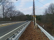 Route 64 heading northbound in West Windsor towards Penns Neck
Route 64 begins at an intersection with County Route 526, County Route 571, and Mercer County Route 615 in the community of West Windsor. From this point, County Routes 526 and 571 continue along the right-of-way towards U.S. Route 130. The route heads north crosses over the Amtrak and New Jersey Transit-used Northeast Corridor Line and passes to the north of a local bus depot. Route 64 continues westward for a short distance, crossing through a local woodland and by several local homes. The route makes a gradual curve to the west off the railroad bridge and passes a couple of homes before heading to the south slightly at a jughandle. Route 64 reaches its northern terminus and County Route 526 and County Route 571 make a right turn to head northwest toward U.S. Route 1.[3]
History
 The former alignment of Route 31-A running to the south of Route 64
Route 31A and the original freeway
In the late-1920s, the state proposed a bypass along the alignment. In 1938, the New Jersey State Highway Department and New Jersey General Assembly put forth a proposal detailing that a highway from State Highway Route 31 (co-signed with U.S. Route 206) in the city of Princeton eastward through Mercer County onto current-day County Route 571. From there, it would follow an alignment of highway to the intersection with State Highway Route 33 in the community of Hightstown. The original proposal for the highway was to turn the road into a limited-access freeway along its entirety. The route was designated as State Highway Route 31A, a suffixed spur of State Highway Route 31 that year.[4] A portion of the highway was constructed in 1939, when a bridge over the Pennsylvania Railroad was constructed from Washington Road's former alignment to the current intersection with Route 615.[1] This new, 104.00 feet (31.70 m) long bridge replaced the at-grade crossing on Washington Road,[5] which is now a dead-end.[6] The state highway law was amended just three years later, with the freeway option removed and the extensions remaining.[7]
 Route 31A (1938-1953)
The new bridge remained in place along Route 31A, however, no new portions of the freeway were constructed in terms of creating the Route 31A Freeway, as proposed in 1938.[4] In 1950, then-governor of New Jersey, Alfred E. Driscoll, cited the need for the expressway as an important truck and passenger car highway from Trenton to the Jersey Shore.[8] Route 31A itself was decommissioned in the 1953 New Jersey state highway renumbering, and replaced by the designation of Route 64.[9] The route was truncated from both ends toward Princeton and Hightstown, leaving just the bridge in West Windsor.[10] Route 31A remained in the state highway statutes for several decades after decommissioning, with a bill in 1991 being proposed. The bill passed, and Route 31A was stripped from the statutes on January 18, 1992.[11]
Route 92 and future changes to CR 571
See also: New Jersey Route 92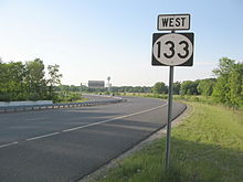 Route 133 west at the eastern beginning. Route 133 was a portion of the partially completed Route 92
Route 64, after designation in 1953,[9] remained a short bridge along the highway.[12] However, the need for an expressway from Trenton to the Jersey Shore remained, and in the late 1950s, the State Highway Department brought about plans for the Princeton–Hightstown Bypass, a four-lane freeway that would head for 14 miles (23 km) from U.S. Route 206 in Montgomery Township to New Jersey Route 33 in Hightstown. In the length, the freeway was to interchange with U.S. Route 1, U.S. Route 130 and New Jersey Route 27. The route was re-designated as Route 92,[13] and remained a high priority project for several decades. Even after changes in alignment, Route 64 was still an alternative.[14] However, Route 92 was shelved on December 1, 2006 in favor of widening the New Jersey Turnpike mainline,[15] and only New Jersey Route 133 was constructed for the proposal.[16]
As part of the proposed Penns Neck Bypass on U.S. Route 1, the New Jersey Department of Transportation plans on realigning County Route 571 and Route 526 from the western terminus of Route 64 to a northerly route to Route 1.[17] Although Route 571 and Route 526 are proposed to be realigned onto the new alignment, there is no designated change proposed for Route 64. On the contrary to this, one state figure shows Route 64 running along Washington Road, where the two county routes currently run.[17][18]
Major intersections
The entire route is in West Windsor, Mercer County.
Mile[2] Destinations Notes 0.00 CR 526 east / CR 571 south / CR 615 north (Hightstown Road)Southern terminus of County Route 615 0.32 CR 526 west / CR 571 north (Washington Road)1.000 mi = 1.609 km; 1.000 km = 0.621 mi See also
 U.S. Roads portal
 New Jersey portal
- List of state highways in the United States shorter than one mile
- New Jersey Route 13
- New Jersey Route 162
References
- ^ a b Structure Number: ++++++++1117150. United States Department of Transportation. 2009.
- ^ a b "Route 64 Straight Line Diagram". New Jersey Department of Transportation. 2009. pp. 1. http://www.state.nj.us/transportation/refdata/sldiag/00000064__-.pdf. Retrieved August 24, 2009.
- ^ Microsoft Inc. (2009). Bing Maps - Overview map of Route 64 (Map). http://www.bing.com/maps/default.aspx?q=Penns+Neck+NJ&mkt=en-US&FORM=BYFD#JnJ0cD1wb3MucXFrbm4zOHNmZ3M3X25lYXIrSGlnaHRzdG93bitSZCUyYytQcmluY2V0b24rSnVuY3Rpb24lMmMrTmV3K0plcnNleSswODU1MCUyYytVbml0ZWQrU3RhdGVzX19fZV8lN2Vwb3MucXFtMjN6OHNmNjdkX25lYXIrV2FzaGluZ3RvbitSZCslMjZhbXAlM2IrTWFqb3IrUmQlMmMrUHJpbmNldG9uK0p1bmN0aW9uJTJjK05ldytKZXJzZXkrMDg1NTAlMmMrVW5pdGVkK1N0YXRlc19fX2VfJnJ0b3A9MCU3ZTA=. Retrieved August 24, 2009.
- ^ a b ROUTE NO. 31A. Beginning in State highway route No. 31 in or near Princeton, and thence to a point at or near Hightstown and connecting there with State highway route No. 33 eastwardly of Hightstown.. New Jersey State Assembly. 1938.
- ^ United States Geological Survey (1909). Southeastern portion of the Princeton, New Jersey quadrangle (Map).
- ^ Google, Inc. Google Maps – Overview of old Route 31A (Map). Cartography by Google, Inc. http://maps.google.com/maps?f=d&source=s_d&saddr=&daddr=&hl=en&geocode=&mra=mr&ie=UTF8&ll=40.318189,-74.621437&spn=0.002646,0.006866&z=18. Retrieved August 27, 2009.
- ^ ROUTE NO. 31A. Beginning in State highway route No. 31 in or near Princeton, and thence to a point at or near Hightstown and connecting there with State highway route No. 33 eastwardly of Hightstown.. New Jersey State Assembly. 1941.
- ^ Alfred E. Driscoll (1950). State of New Jersey. "My studies have very definitely indicated that it is unwise to expect city streets to bear the brunt of through, truck and passenger traffic. A continuous line of trucks, or, for that matter, passenger cars, bound from the Trenton area to the seashore, or desiring to get on the (New Jersey) Turnpike after it is completed, may constitute a (brick wall) "Chinese Wall" just as effectively as an underpass or overpass."
- ^ a b 1953 renumbering. New Jersey Department of Highways. http://en.wikisource.org/wiki/1953_New_Jersey_state_highway_renumbering. Retrieved July 31, 2009.
- ^ State of New Jersey, Laws of 1953, Chapter 112, Page 1298, Section 1.
- ^ State of New Jersey, Laws of 1991, Page 1298, Section 2.
- ^ American Oil Company (1959). New Jersey (Map). Cartography by General Drafting Inc..
- ^ "Proposed Expressways in New York City". Regional Plan Association News. May 1964. http://www.nycroads.com/history/expwy-map_metro/. Retrieved 2009-09-09.
- ^ New Jersey State Legislature (December 18, 1991). Public Hearing for Proposed Route 92 Freeway. New Jersey Department of Transportation.
- ^ "Turnpike Won't Add Toll Link to Route 1". The Asbury Park Press. December 2, 2006.
- ^ Armone, Michael (December 1, 1999). "Long Wait Is Over". The Trenton Times.
- ^ a b University, Rutgers (2009). Route 1/Penns Neck Area Final Enivornmental Impact Statement. New Jersey Department of Transportation.
- ^ University, Rutgers (2009). Route 1/Penns Neck Area Final Enivornmental Impact Statement - Figure 7-1. New Jersey Department of Transportation. http://www.state.nj.us/transportation/works/studies/pennsneck/pdf/app_c_7_1.pdf. Retrieved August 24, 2009.
External links
- Moraseski, Dan (2009). "64". Alps Roads. http://www.alpsroads.net/roads/nj/log/6.html#64. Retrieved August 24, 2009.
- "Speed Limits for State Roads: Route 64". New Jersey Department of Transportation. 2009. http://www.state.nj.us/transportation/refdata/traffic_orders/speed/rt64.shtm. Retrieved August 24, 2009.
Categories:- State highways in New Jersey
- Transportation in Mercer County, New Jersey


Wikimedia Foundation. 2010.