- Chilthorne Domer
-
Coordinates: 50°58′22″N 2°40′40″W / 50.9729°N 2.6778°W
Chilthorne Domer 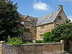
Manor House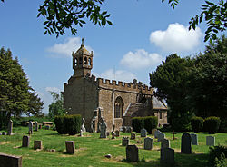
Church of the Blessed Virgin Mary
 Chilthorne Domer
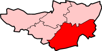
Chilthorne Domer shown within SomersetPopulation 569 [1] OS grid reference ST525195 District South Somerset Shire county Somerset Region South West Country England Sovereign state United Kingdom Post town YEOVIL Postcode district BA22 Dialling code 01935 Police Avon and Somerset Fire Devon and Somerset Ambulance South Western EU Parliament South West England UK Parliament Yeovil List of places: UK • England • Somerset Chilthorne Domer is a village and parish in Somerset, England, situated 4 miles (6.4 km) north west of Yeovil in the South Somerset district. The village has a population of 569.[1] It is situated on the old coach road from Ilchester to Yeovil.
Contents
History
The village was known as Cilterne in the Domesday Book of 1086, which is a British hill name including the element celto meaning high. The second part of the name coming from the Domer family who held one of the manors. The other was held by the Vagg family and was known as Chiltorne Vagg.[2] This survives in the name of Vagg farm[3] south east of the village.[2]
The parish of Chilthorne Domer was part of the Stone Hundred.[4]
The manor house was built in the 17th century and has its own well.[5] In the garden about 70 feet (21 m) south of the house is a six seater privy built about 1720,[2] which in regular use until 1939.[6]
Governance
The parish council has responsibility for local issues, including setting an annual precept (local rate) to cover the council’s operating costs and producing annual accounts for public scrutiny. The parish council evaluates local planning applications and works with the local police, district council officers, and neighbourhood watch groups on matters of crime, security, and traffic. The parish council's role also includes initiating projects for the maintenance and repair of parish facilities, as well as consulting with the district council on the maintenance, repair, and improvement of highways, drainage, footpaths, public transport, and street cleaning. Conservation matters (including trees and listed buildings) and environmental issues are also the responsibility of the council.
The village falls within the Non-metropolitan district of South Somerset, which was formed on April 1, 1974 under the Local Government Act 1972, having previously been part of Yeovil Rural District.[7] The district council is responsible for local planning and building control, local roads, council housing, environmental health, markets and fairs, refuse collection and recycling, cemeteries and crematoria, leisure services, parks, and tourism.
Somerset County Council is responsible for running the largest and most expensive local services such as education, social services, libraries, main roads, public transport, policing and fire services, trading standards, waste disposal and strategic planning.
It is also part of the Yeovil county constituency represented in the House of Commons of the Parliament of the United Kingdom. It elects one Member of Parliament (MP) by the first past the post system of election, and part of the South West England constituency of the European Parliament which elects seven MEPs using the d'Hondt method of party-list proportional representation.
Education
The village has a primary school for children between the ages of 4 and 11.[8]
Religious sites
The Anglican parish Church of St Mary has 13th century origins and has been designated as a Grade II* listed building.[9] It was granted to Bruton Priory in 1301.[2]
Notable residents
Susan Miller took the title Baroness Miller of Chilthorne Domer in 1998 after serving as a councillor at parish, district and county levels from 1987-2005, leading South Somerset District Council and as a member of Somerset County Council.
-

Axesclose Farmhouse
-

The Halfway House
References
- ^ a b "South Somerset population estimates for 2002". Somerset County Council. http://www.webcitation.org/5lRyCVNCk. Retrieved 27 December 2009.
- ^ a b c d Bush, Robin (1994). Somerset: The complete guide. Wimborne, Dorset: Dovecote Press. p. 66. ISBN 1874336261.
- ^ "Lower Vagg Farmhouse". Images of England. English Heritage. http://www.imagesofengland.org.uk/Details/Default.aspx?id=263522. Retrieved 2008-12-14.
- ^ "Somerset Hundreds". GENUKI. http://www.genuki.org.uk/big/eng/SOM/Miscellaneous/. Retrieved 21 October 2011.
- ^ "The Manor House". Images of England. English Heritage. http://www.imagesofengland.org.uk/Details/Default.aspx?id=263515. Retrieved 2008-12-14.
- ^ "Privy, about 35 m south of the Manor House". Images of England. English Heritage. http://www.imagesofengland.org.uk/Details/Default.aspx?id=263519. Retrieved 2008-12-14.
- ^ A Vision of Britain Through Time : Yeovil Rural District
- ^ "Chilthorne Domer Primary School". Chilthorne Domer Primary School. http://www.chilthorneschool.co.uk/home.htm. Retrieved 2008-12-14.
- ^ "Church of St Mary". Images of England. English Heritage. http://www.imagesofengland.org.uk/Details/Default.aspx?id=263508. Retrieved 2008-12-14.
External links
Categories:- Villages in South Somerset
- Civil parishes in Somerset
-


Wikimedia Foundation. 2010.