- Curry Rivel
-
Coordinates: 51°01′32″N 2°51′50″W / 51.0256°N 2.8640°W
Curry Rivel 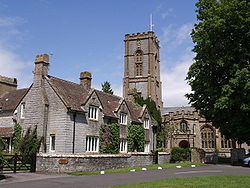
Manor Farmhouse and Church of St Andrew
 Curry Rivel
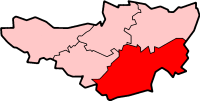
Curry Rivel shown within SomersetPopulation 2,093 [1] OS grid reference ST395255 District South Somerset Shire county Somerset Region South West Country England Sovereign state United Kingdom Post town LANGPORT Postcode district TA10 Dialling code 01458 Police Avon and Somerset Fire Devon and Somerset Ambulance South Western EU Parliament South West England UK Parliament Somerton and Frome List of places: UK • England • Somerset Curry Rivel is a village and civil parish in Somerset, England, situated 6 miles (9.7 km) west of Somerton and 10 miles (16.1 km) east of Taunton in the South Somerset district. The parish has a population of 2,093.[1] The parish includes the hamlet of Burton Pynsent.
Contents
History
The unusual name Curry Rivel, comes from the Celtic word crwy, meaning boundary and Rivel from its 12th-century landlord Sir Richard Revel.[2]
Curry Rivel was part of the hundred of Abdick and Bulstone.[3][4]
Earnshill House was built in 1725 by John Strachan for Henry Combe, a prominent Bristol merchant.[5]
Burton Pynsent House was built around 1756 for William Pitt, after he inherited the estate from Sir William Pynsent.[6] It formed part of a wing on a larger earlier house, that was demolished around 1805. It has been designated by English Heritage as a Grade II* listed building.[7] The grounds were laid out in the mid 18th century by Lancelot Brown and William Pitt, Earl of Chatham, and include early 20th century formal gardens designed by Harold Peto.[8] The Chatham Vase is a stone sculpture commissioned as a memorial to William Pitt the Elder by his wife, Hester, Countess of Chatham. It was originally erected at their house in Burton Pynsent, in 1781, and moved to the grounds of Chevening House in 1934, where it currently resides.
The 140 feet (43 m) Pynsent Column (also known as the Curry Rivel Column, Burton Pynsent Monument, Pynsent Steeple or Cider Monument)[9] stands on Troy Hill, a spur of high ground about 700 m north-east of the house. It was designed in the 18th century by Capability Brown for William Pitt.[10][11] It was restored in the 1990s by the John Paul Getty Trust and English Heritage.[9]
Governance
The parish council has responsibility for local issues, including setting an annual precept (local rate) to cover the council’s operating costs and producing annual accounts for public scrutiny. The parish council evaluates local planning applications and works with the local police, district council officers, and neighbourhood watch groups on matters of crime, security, and traffic. The parish council's role also includes initiating projects for the maintenance and repair of parish facilities, as well as consulting with the district council on the maintenance, repair, and improvement of highways, drainage, footpaths, public transport, and street cleaning. Conservation matters (including trees and listed buildings) and environmental issues are also the responsibility of the council.
The village falls within the Non-metropolitan district of South Somerset, which was formed on 1 April 1974 under the Local Government Act 1972, having previously been part of Langport Rural District.[12] The district council is responsible for local planning and building control, local roads, council housing, environmental health, markets and fairs, refuse collection and recycling, cemeteries and crematoria, leisure services, parks, and tourism.
Somerset County Council is responsible for running the largest and most expensive local services such as education, social services, libraries, main roads, public transport, policing and fire services, trading standards, waste disposal and strategic planning.
It is also part of the Somerton and Frome county constituency represented in the House of Commons of the Parliament of the United Kingdom. It elects one Member of Parliament (MP) by the first past the post system of election, and part of the South West England constituency of the European Parliament which elects seven MEPs using the d'Hondt method of party-list proportional representation.
Religious sites
The Anglican parish Church of St Andrew dates from the 13th century and is designated as a Grade I listed building.[13]
References
- ^ a b "South Somerset population estimates for 2002". Somerset County Council. http://www.webcitation.org/5lRyCVNCk. Retrieved 27 December 2009.
- ^ "Curry Rivel Column (Burton Pynsent)". Folly Towers. Archived from the original on 22 February 2008. http://web.archive.org/web/20080222065624/http://www.follytowers.com/curryrival.html. Retrieved 5 July 2008.
- ^ "Abdick and Bulstone Hundred Through Time". A Vision of Britain Through Time. http://www.visionofbritain.org.uk/relationships.jsp?u_id=10133830. Retrieved 9 September 2011.
- ^ "Abdick and Bulstone in South Somerset". A Vision Britain Through Time. http://www.visionofbritain.org.uk/place/place_page.jsp?p_id=21175. Retrieved 9 September 2011.
- ^ "Earnshill House". Images of England. English Heritage. http://www.imagesofengland.org.uk/Details/Default.aspx?id=431284. Retrieved 12 October 2008.
- ^ "Burton Pynsent, Yeovil, England". Parks & Gardens UK. Parks and Gardens Data Services Limited (PGDS). http://www.parksandgardens.ac.uk/component/option,com_parksandgardens/task,site/id,629/tab,history/Itemid,/. Retrieved 17 September 2008.
- ^ "Burton Pynsent House". Images of England. English Heritage. http://www.imagesofengland.org.uk/Details/Default.aspx?id=431249. Retrieved 5 July 2008.
- ^ "Burton Pynsent". Somerset Historic Environment Record. Somerset County Council. http://webapp1.somerset.gov.uk/her/details.asp?prn=55167. Retrieved 5 July 2008.
- ^ a b Holt, Jonathan. Somerset Follies. Akeman Press. pp. 76–77. ISBN 9780954613877.
- ^ "Curry Rivel Column (Burton Pynsent)". Folly Towers. Archived from the original on 22 February 2008. http://web.archive.org/web/20080222065624/http://www.follytowers.com/curryrival.html. Retrieved 5 July 2008.
- ^ "Burton Pynsent Monument". Images of England. English Heritage. http://www.imagesofengland.org.uk/Details/Default.aspx?id=431251. Retrieved 5 July 2008.
- ^ A Vision of Britain Through Time : Langport Rural District
- ^ "Church of St Andrew". Images of England. English Heritage. http://www.imagesofengland.org.uk/Details/Default.aspx?id=431260. Retrieved 12 October 2008.
External links
Categories:- Villages in South Somerset
- Civil parishes in Somerset


Wikimedia Foundation. 2010.