- Dinnington, Somerset
-
For other uses, see Dinnington (disambiguation).
Coordinates: 50°54′32″N 2°50′51″W / 50.9088°N 2.8476°W
Dinnington 
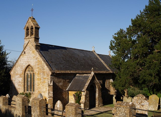
St Nicholas' Church
 Dinnington
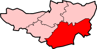
Dinnington shown within SomersetPopulation 65 [1] OS grid reference ST405125 District South Somerset Shire county Somerset Region South West Country England Sovereign state United Kingdom Post town CREWKERNE Postcode district TA17 Dialling code 01460 Police Avon and Somerset Fire Devon and Somerset Ambulance South Western EU Parliament South West England UK Parliament Yeovil List of places: UK • England • Somerset Dinnington is a village and civil parish in English county of Somerset, situated 4 miles (6.4 km) north of Crewkerne in the South Somerset district. The village has a population of 65.[1]
Contents
History
The name Dinnington means the settlement of Dynne's people.[2]
The parish was crossed by the Fosse Way and nearby there is evidence of a Roman villa,[3] which was excavated by the Time Team in 2002 and 2006.[4] The Romano British site has been the site of surface finds of tesserae, roofing slates and pottery. A number of coins have been found and also a small bronze dog.[5]
The manor was held at the time of the Domesday Book in 1086 by Siward the falconer. The parish of Dinnington was part of the South Petherton Hundred.[6] In the 15th century the manor passed to the Pouletts of Hinton St George.[2]
The village is near the route of the Chard Canal.
Governance
The parish council has responsibility for local issues, including setting an annual precept (local rate) to cover the council’s operating costs and producing annual accounts for public scrutiny. The parish council evaluates local planning applications and works with the local police, district council officers, and neighbourhood watch groups on matters of crime, security, and traffic. The parish council's role also includes initiating projects for the maintenance and repair of parish facilities, as well as consulting with the district council on the maintenance, repair, and improvement of highways, drainage, footpaths, public transport, and street cleaning. Conservation matters (including trees and listed buildings) and environmental issues are also the responsibility of the council.
The village falls within the Non-metropolitan district of South Somerset, which was formed on April 1, 1974 under the Local Government Act 1972, having previously been part of Chard Rural District.[7] The district council is responsible for local planning and building control, local roads, council housing, environmental health, markets and fairs, refuse collection and recycling, cemeteries and crematoria, leisure services, parks, and tourism.
Somerset County Council is responsible for running the largest and most expensive local services such as education, social services, libraries, main roads, public transport, policing and fire services, trading standards, waste disposal and strategic planning.
It is also part of the Yeovil county constituency represented in the House of Commons of the Parliament of the United Kingdom. It elects one Member of Parliament (MP) by the first past the post system of election, and part of the South West England constituency of the European Parliament which elects seven MEPs using the d'Hondt method of party-list proportional representation.
Religious sites
The Anglican parish Church of St Nicholas was established by 1207. The current building is mostly from the 15th century with restoration in 1863.[8] It was originally a chapelry to Seavington St Mary.[2]
In 1873 a bible chapel was built and continued to be used by the methodists until 1956. In 1964 taken over by the Elim Pentecostal Church at Merriott.[9]
References
- ^ a b "South Somerset population estimates for 2002". Somerset County Council. http://www.webcitation.org/5lRyCVNCk. Retrieved 27 December 2009.
- ^ a b c Bush, Robin (1994). Somerset: The Complete Guide. Dovecote Press. pp. 81. ISBN 1874336261.
- ^ "Villa mosaic's secrets revealed". BBC News. BBC. 2006-07-11. http://news.bbc.co.uk/1/hi/england/somerset/5171108.stm. Retrieved 2009-01-04.
- ^ "Dinnington, Somerset". Time Team. Chanel 4. http://www.channel4.com/history/microsites/T/timeteam/2006_dinn.html. Retrieved 2009-01-04.
- ^ "Roman villa, Northfield Lane, Dinnington". Somerset Historic Environment Record. Somerset County Council. http://webapp1.somerset.gov.uk/her/details.asp?prn=53887. Retrieved 2009-01-04.
- ^ "Somerset Hundreds". GENUKI. http://www.genuki.org.uk/big/eng/SOM/Miscellaneous/. Retrieved 20 October 2011.
- ^ A Vision of Britain Through Time : Chard Rural District
- ^ "Church of St Nicholas". Images of England. English Heritage. http://www.imagesofengland.org.uk/Details/Default.aspx?id=264091. Retrieved 2009-01-04.
- ^ "Former Bible Christian Chapel". Images of England. English Heritage. http://www.imagesofengland.org.uk/Details/Default.aspx?id=264089. Retrieved 2009-01-04.
External links
 Media related to Dinnington, Somerset at Wikimedia CommonsCategories:
- Villages in South Somerset
- Civil parishes in Somerset

Wikimedia Foundation. 2010.