County of Churchill, Queensland

County of Churchill, Queensland
Churchill
Queensland
Churchill-county-queensland.png
Location within Queensland
Lands administrative divisions around Churchill
Aubigny Cavendish Stanley
Aubigny Churchill Stanley
Merivale Merivale Ward

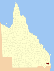
The County of Churchill is a county in Queensland, Australia. Like all counties in Queensland, it is a non-functional administrative unit, that is used mainly for the purpose of registering land titles. The county lies between 152°E and 153°E longitude, and is centred on the West Moreton region, extending east to the suburbs of Ipswich.[1] The county was named for Lord Randolph Churchill, who was born in 1849, by the Surveyor-General of New South Wales the following year; the area was officially named and bounded by the Governor in Council on 7 March 1901 under the Land Act 1897.[2]

Parishes

Churchill is divided into parishes, as listed below:

Parish LGA Coordinates
Alfred Ipswich 27°42′S 152°26′E / 27.7°S 152.433°E / -27.7; 152.433 (Alfred Parish)
Blenheim Lockyer Valley 27°36′S 152°19′E / 27.6°S 152.317°E / -27.6; 152.317 (Blenheim Parish)
Brassall Ipswich 27°32′S 152°42′E / 27.533°S 152.7°E / -27.533; 152.7 (Brassall Parish)
Campbell Lockyer Valley 27°38′S 152°03′E / 27.633°S 152.05°E / -27.633; 152.05 (Campbell Parish)
Clumber Scenic Rim 28°06′S 152°30′E / 28.1°S 152.5°E / -28.1; 152.5 (Clumber Parish)
Colin Lockyer Valley 27°43′S 152°02′E / 27.717°S 152.033°E / -27.717; 152.033 (Colin Parish)
East Haldon Lockyer Valley 27°52′S 152°14′E / 27.867°S 152.233°E / -27.867; 152.233 (East Haldon Parish)
Fassifern Scenic Rim 27°57′S 152°33′E / 27.95°S 152.55°E / -27.95; 152.55 (Fassifern Parish)
Ferguson Ipswich 27°42′S 152°30′E / 27.7°S 152.5°E / -27.7; 152.5 (Ferguson Parish)
Flagstone Lockyer Valley 27°37′S 152°03′E / 27.617°S 152.05°E / -27.617; 152.05 (Flagstone Parish)
Flinders Scenic Rim 27°46′S 152°41′E / 27.767°S 152.683°E / -27.767; 152.683 (Flinders Parish)
Forbes Scenic Rim 27°46′S 152°33′E / 27.767°S 152.55°E / -27.767; 152.55 (Forbes Parish)
Franklin Ipswich 27°47′S 152°26′E / 27.783°S 152.433°E / -27.783; 152.433 (Franklin Parish)
Gatton Lockyer Valley 27°35′S 152°17′E / 27.583°S 152.283°E / -27.583; 152.283 (Gatton Parish)
Goolman Scenic Rim 27°49′S 152°47′E / 27.817°S 152.783°E / -27.817; 152.783 (Goolman Parish)
Grandchester Lockyer Valley 27°37′S 152°30′E / 27.617°S 152.5°E / -27.617; 152.5 (Grandchester Parish)
Jeebropilly Ipswich 27°39′S 152°38′E / 27.65°S 152.633°E / -27.65; 152.633 (Jeebropilly Parish)
Laidley Lockyer Valley 27°37′S 152°23′E / 27.617°S 152.383°E / -27.617; 152.383 (Laidley Parish)
Mort Lockyer Valley 27°43′S 152°21′E / 27.717°S 152.35°E / -27.717; 152.35 (Mort Parish)
Mutdapilly Ipswich 27°43′S 152°36′E / 27.717°S 152.6°E / -27.717; 152.6 (Mutdapilly Parish)
Normanby Scenic Rim 27°51′S 152°37′E / 27.85°S 152.617°E / -27.85; 152.617 (Normanby Parish)
North Somerset 27°28′S 152°38′E / 27.467°S 152.633°E / -27.467; 152.633 (North Parish)
Purga Ipswich 27°40′S 152°44′E / 27.667°S 152.733°E / -27.667; 152.733 (Purga Parish)
Rosevale Scenic Rim 27°52′S 152°26′E / 27.867°S 152.433°E / -27.867; 152.433 (Rosevale Parish)
Rosewood Lockyer Valley 27°31′S 152°29′E / 27.517°S 152.483°E / -27.517; 152.483 (Rosewood Parish)
Tarampa Somerset 27°29′S 152°33′E / 27.483°S 152.55°E / -27.483; 152.55 (Tarampa Parish)
Taylor Lockyer Valley 27°30′S 152°00′E / 27.5°S 152°E / -27.5; 152 (Taylor Parish)
Tenthill Lockyer Valley 27°38′S 152°14′E / 27.633°S 152.233°E / -27.633; 152.233 (Tenthill Parish)
Terry Lockyer Valley 27°35′S 152°07′E / 27.583°S 152.117°E / -27.583; 152.117 (Terry Parish)
Thorn Scenic Rim 27°52′S 152°32′E / 27.867°S 152.533°E / -27.867; 152.533 (Thorn Parish)
Thornton Lockyer Valley 27°47′S 152°21′E / 27.783°S 152.35°E / -27.783; 152.35 (Thornton Parish)
Townson Lockyer Valley 27°53′S 152°22′E / 27.883°S 152.367°E / -27.883; 152.367 (Townson Parish)
Walloon Ipswich 27°35′S 152°40′E / 27.583°S 152.667°E / -27.583; 152.667 (Walloon Parish)
Whitestone Lockyer Valley 27°45′S 152°12′E / 27.75°S 152.2°E / -27.75; 152.2 (Whitestone Parish)

References

  1. ^ Moreton District, County of Churchill Maps - A4 Series at Queensland Archives.
  2. ^ Department of Environment and Resource Management. "Place name details — Churchill". http://www.derm.qld.gov.au/property/placenames/details.php?id=7228. Retrieved 4 June 2011. 


Coordinates: 27°50′S 152°20′E / 27.833°S 152.333°E / -27.833; 152.333


Wikimedia Foundation. 2010.

Игры ⚽ Поможем сделать НИР

Look at other dictionaries:

  • County of Stanley, Queensland — Map of all coordinates from Google Map of all coordinates from Bing Export all coordinates as KML …   Wikipedia

  • County of Ward, Queensland — Ward Queensland Location within Queensland Lands administrative divisions around Ward …   Wikipedia

  • Churchill County, Nevada — This article is about the county in the US State of Nevada. For the county in the Australian state of Queensland, see County of Churchill, Queensland. Churchill County, Nevada …   Wikipedia

  • Churchill County — may refer to: Places Churchill County, Nevada Churchill County, Queensland Ships USS Churchill County (LST 583), a United States Navy tank landing ship in commission as USS LST 583 from 1944 to 1946 and as USS Churchill County from 1960 to 1968… …   Wikipedia

  • Churchill (disambiguation) — Winston Churchill was a British politician who led the United Kingdom during World War II. Churchill may also refer to: Contents 1 Geography 1.1 Antarctica 1.2 …   Wikipedia

  • Cadastral divisions of Queensland — refers to the divisions of Queensland used for the registration of land titles. There are 322 counties, and 5,319 parishes within the state. [http://www.nrw.qld.gov.au/museum/articles complete/mapping/cad.html] . They are part of the cadastral… …   Wikipedia

  • County of Merivale — Merivale Queensland Location within Queensland Lands administrative divisions around Mer …   Wikipedia

  • County of Aubigny — Aubigny Queensland Location within Queensland Lands administrative divisions around Aubigny …   Wikipedia

  • County of Cavendish — Cavendish Queensland Location within Queensland Lands administrative divisions around …   Wikipedia

  • Murphys Creek, Queensland — Murphys Creek Queensland Population: 449[1] Postcode: 4352 …   Wikipedia

Share the article and excerpts

Direct link
Do a right-click on the link above
and select “Copy Link”