- National Register of Historic Places listings in San Bernardino County, California
-
This list includes properties and districts listed on the National Register of Historic Places in San Bernardino County, California. Click the "Map of all coordinates" link to the right to view a Google map of all properties and districts with latitude and longitude coordinates in the table below.[1]
-
- This National Park Service list is complete through NPS recent listings posted November 10, 2011.[2]
[3] Landmark name [4] Image Date listed Location City or town Summary 1 A. K. Smiley Public Library 
December 12, 1976 125 W. Vine St.
34°03′15″N 117°10′59″W / 34.054167°N 117.183056°WRedlands 2 Aiken's Wash National Register District May 24, 1982 Address Restricted Baker 3 Archeological Site CA SBR 3186 February 10, 1981 Address Restricted Silver Lake 4 Archeological Site CA-SBR-140 June 10, 2003 Address Restricted Baker 5 Archeological Site No. D-4 October 25, 1985 Address Restricted Needles 6 Archeological Site No. E-21 October 25, 1985 Address Restricted Parker 7 Atchison, Topeka and Santa Fe Railway Passenger and Freight Depot 
February 2, 2001 1170 W. 3rd St.
34°06′17″N 117°18′31″W / 34.104722°N 117.308611°WSan Bernardino 8 Barton Villa October 24, 1996 11245 Nevada St.
34°02′58″N 117°12′58″W / 34.049444°N 117.216111°WRedlands 9 Beverly Ranch February 11, 2004 923 W. Fern Ave.
34°02′39″N 117°11′16″W / 34.044167°N 117.187778°WRedlands 10 Bitter Spring Archaeological Site (4-SBr-2659) December 20, 1982 Address Restricted Barstow 11 Black Canyon-Inscription Canyon-Black Mountain Rock Art District September 12, 2000 Address Restricted Hinkley 12 Blackwater Well November 21, 2000 Address Restricted Red Mountain 13 Bono's Restaurant and Deli January 10, 2008 15395 Foothill Blvd.
34°06′23″N 117°28′05″W / 34.106389°N 117.468056°WFontana 14 CA SBr 1008A, CA SBr 1008B, CA SBr 1008C May 24, 1982 Address Restricted Johannesburg 15 Calico Mountains Archeological District March 30, 1973 Address Restricted Yermo 16 The California Theatre 
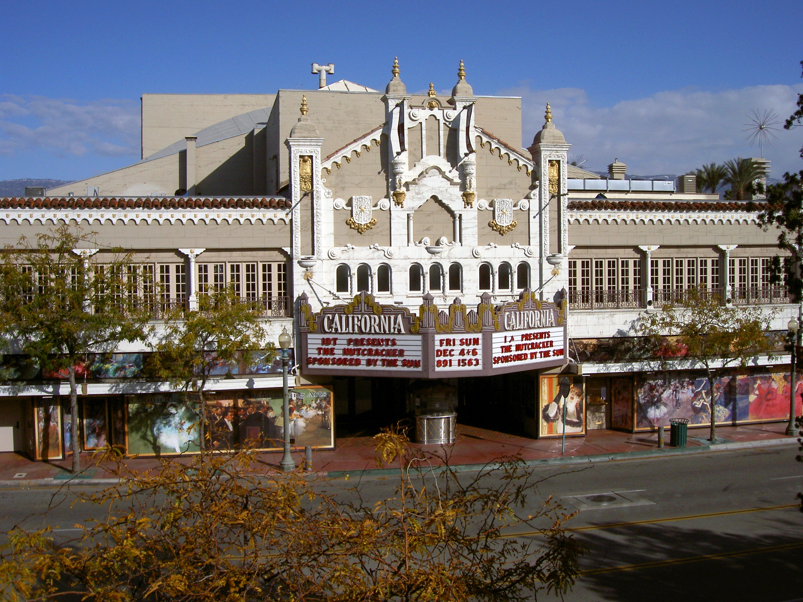
December 22, 2009 562 W. 4th St.
34°06′25″N 117°17′44″W / 34.106814°N 117.29545°WSan Bernardino 17 Carnegie Public Library Building 
June 23, 1988 380 N. La Cadena Dr.
34°04′08″N 117°19′22″W / 34.068889°N 117.322778°WColton Now houses Colton Area Museum 18 Cow Camp 
October 29, 1975 SW of Twentynine Palms in Joshua Tree National Park
34°02′15″N 116°10′02″W / 34.0375°N 116.167222°WTwentynine Palms 19 Crowder Canyon Archeological District June 16, 1976 Address Restricted San Bernardino 20 El Garces 
May 17, 2002 950 Front St.
34°50′27″N 114°36′20″W / 34.840833°N 114.605556°WNeedles 21 Euclid Avenue 
August 10, 2005 From 24th St. in Upland to Philadelphia St. in Ontario
34°09′01″N 117°39′02″W / 34.150278°N 117.650556°WUpland and Ontario 22 First Christian Church of Rialto 
February 20, 2003 201 N. Riverside Ave.
34°06′10″N 117°22′09″W / 34.102778°N 117.369167°WRialto 23 Fontana Farms Company Ranch House, Camp No. 1 November 1, 1982 8863 Pepper St.
34°05′34″N 117°26′28″W / 34.092778°N 117.441111°WFontana 24 Fontana Pit and Groove Petroglyph Site April 17, 1980 Address Restricted Fontana 25 Fossil Canyon Petroglyph Site March 3, 2003 Address Restricted Barstow 26 Foxtrot Petroglyph Site February 23, 1995 Address Restricted Twentynine Palms 27 Frankish Building August 11, 1980 200 S. Euclid Ave.
34°03′45″N 117°39′01″W / 34.0625°N 117.650278°WOntario 28 Goffs Schoolhouse October 11, 2001 37198 Lanfair Rd.
34°55′12″N 115°03′18″W / 34.92°N 115.055°WGoffs 29 Harvey House Railroad Depot 
April 3, 1975 Santa Fe Depot
34°54′17″N 117°01′26″W / 34.904722°N 117.023889°WBarstow 30 Highland Historic District April 5, 2001 Roughly bounded by Cole and Nona Ave., Pacific and Church Sts.
34°07′40″N 117°12′29″W / 34.127778°N 117.208056°WHighland 31 Hofer Ranch July 8, 1993 11248 S. Turner Ave.
34°02′56″N 117°35′05″W / 34.048889°N 117.584722°WOntario 32 Kelso Depot, Restaurant and Employees Hotel 
August 2, 2001 Kelbaker Rd., jct. of Kelbaker and Cima Rds. at Union Pacific Railroad crossing
35°00′44″N 115°39′09″W / 35.012222°N 115.6525°WKelso 33 Keys Desert Queen Ranch 
October 30, 1975 SW of Twentynine Palms in Joshua Tree National Park
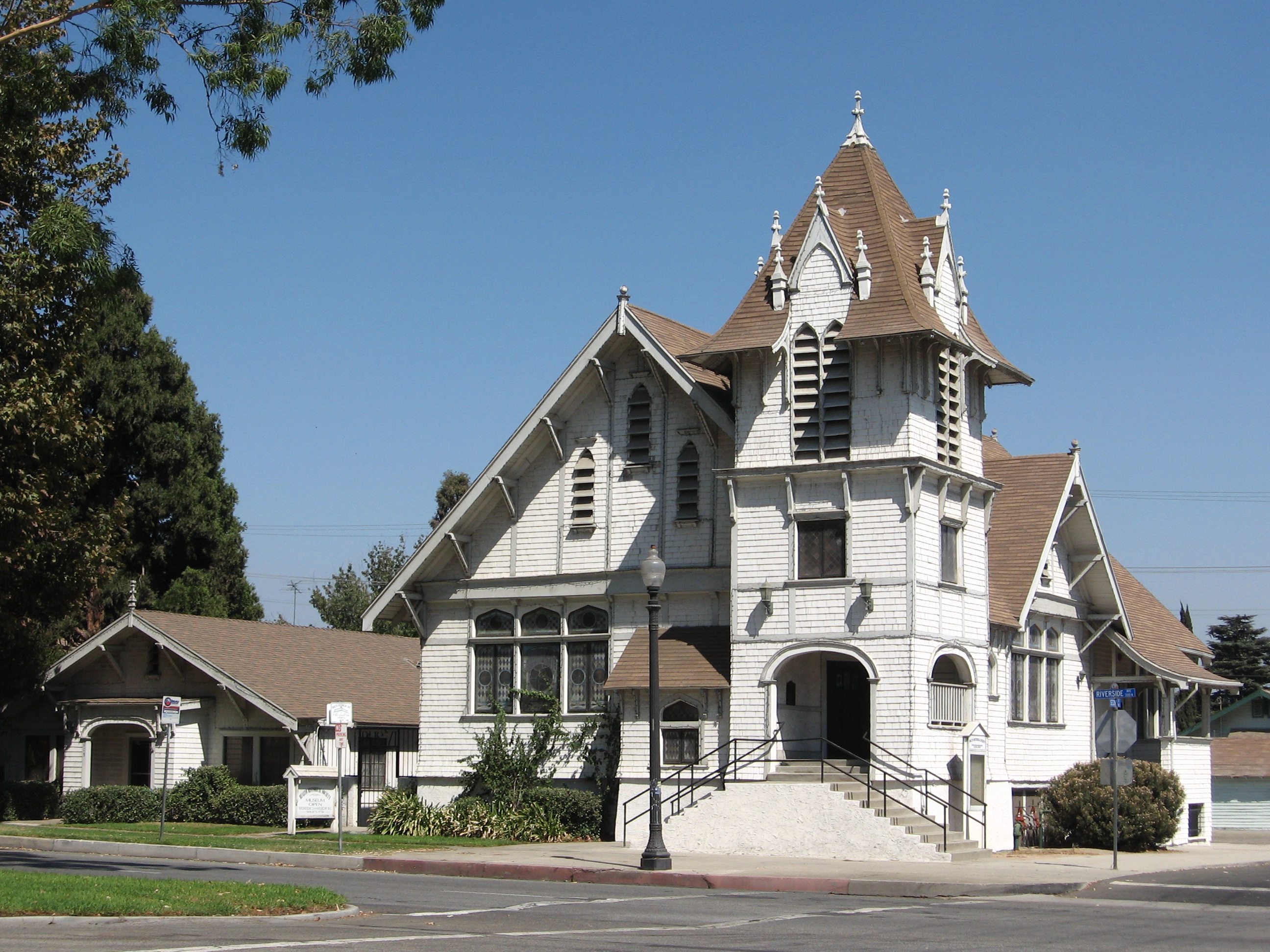
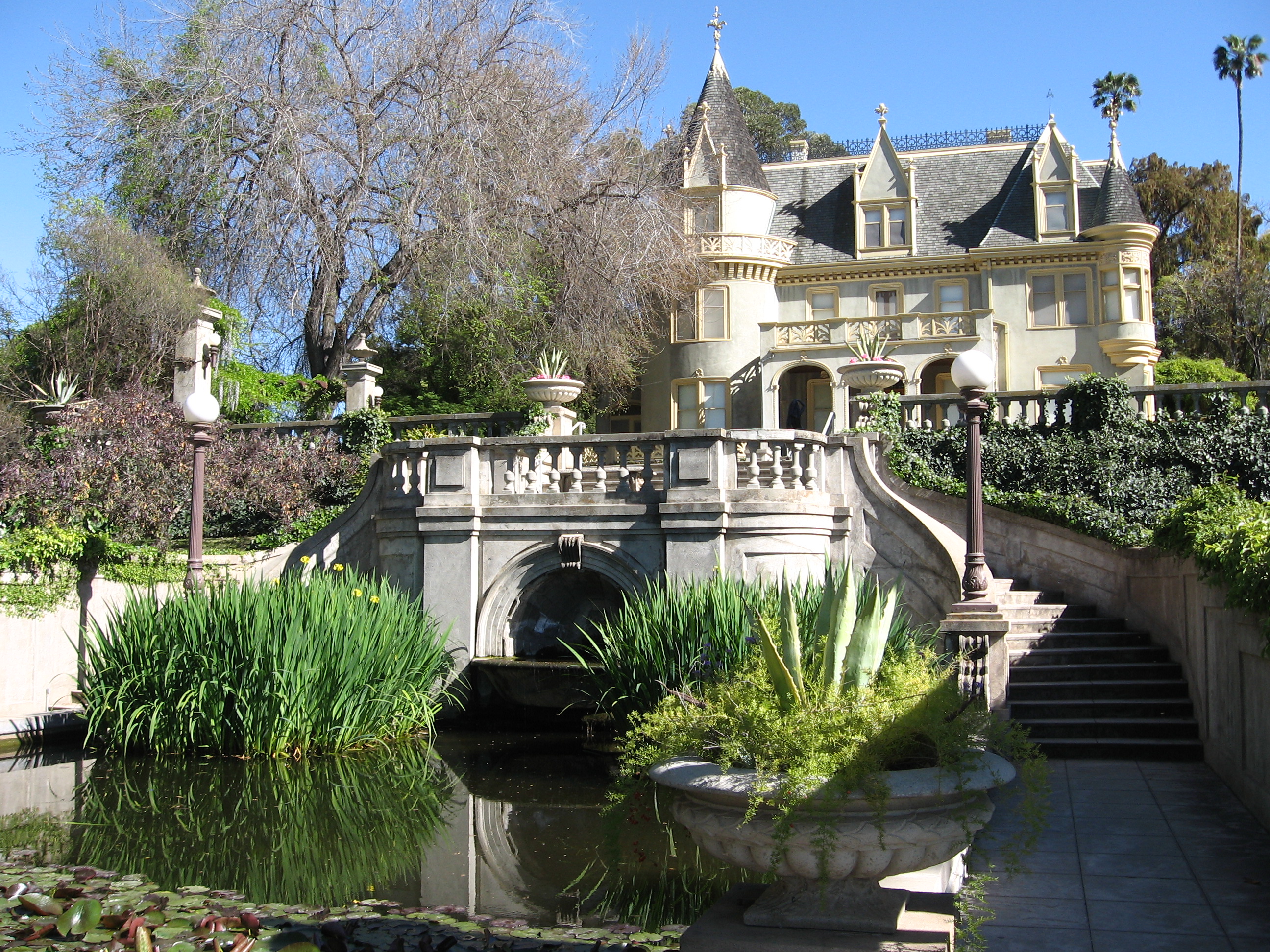
34°02′36″N 116°09′59″W / 34.043333°N 116.166389°WTwentynine Palms 34 Kimberly Crest 
March 28, 1996 1325 Prospect Dr.
34°02′16″N 117°10′21″W / 34.037778°N 117.1725°WRedlands 35 Sam and Alfreda Maloof Compound 
November 9, 2010 5131 Carnelian St.
34°09′40″N 117°36′56″W / 34.161111°N 117.615556°WAlta Loma 36 Mill Creek Zanja May 12, 1977 Sylvan Blvd. E to Mill Creek Rd.
34°03′44″N 117°07′23″W / 34.062222°N 117.123056°WRedlands 37 Moyse Building February 28, 1979 13150 7th St.
34°00′53″N 117°41′23″W / 34.014722°N 117.689722°WChino 38 Newberry Cave Site November 21, 2000 Address Restricted Newberry Springs 39 Old San Antonio Hospital January 2, 1980 792 W. Arrow Hwy.
34°05′58″N 117°39′34″W / 34.099444°N 117.659444°WUpland 40 Ontario State Bank Block January 8, 1982 300 S. Euclid Ave.
34°03′42″N 117°39′02″W / 34.061667°N 117.650556°WOntario 41 Pacific Electric Etiwanda Depot March 21, 2011 7092 Etiwanda Ave.
34°07′30″N 117°31′23″W / 34.125°N 117.523056°WRancho Cucamonga 42 Pioneer Deep Space Station 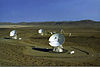
October 3, 1985 Goldstone Deep Space Communications Complex
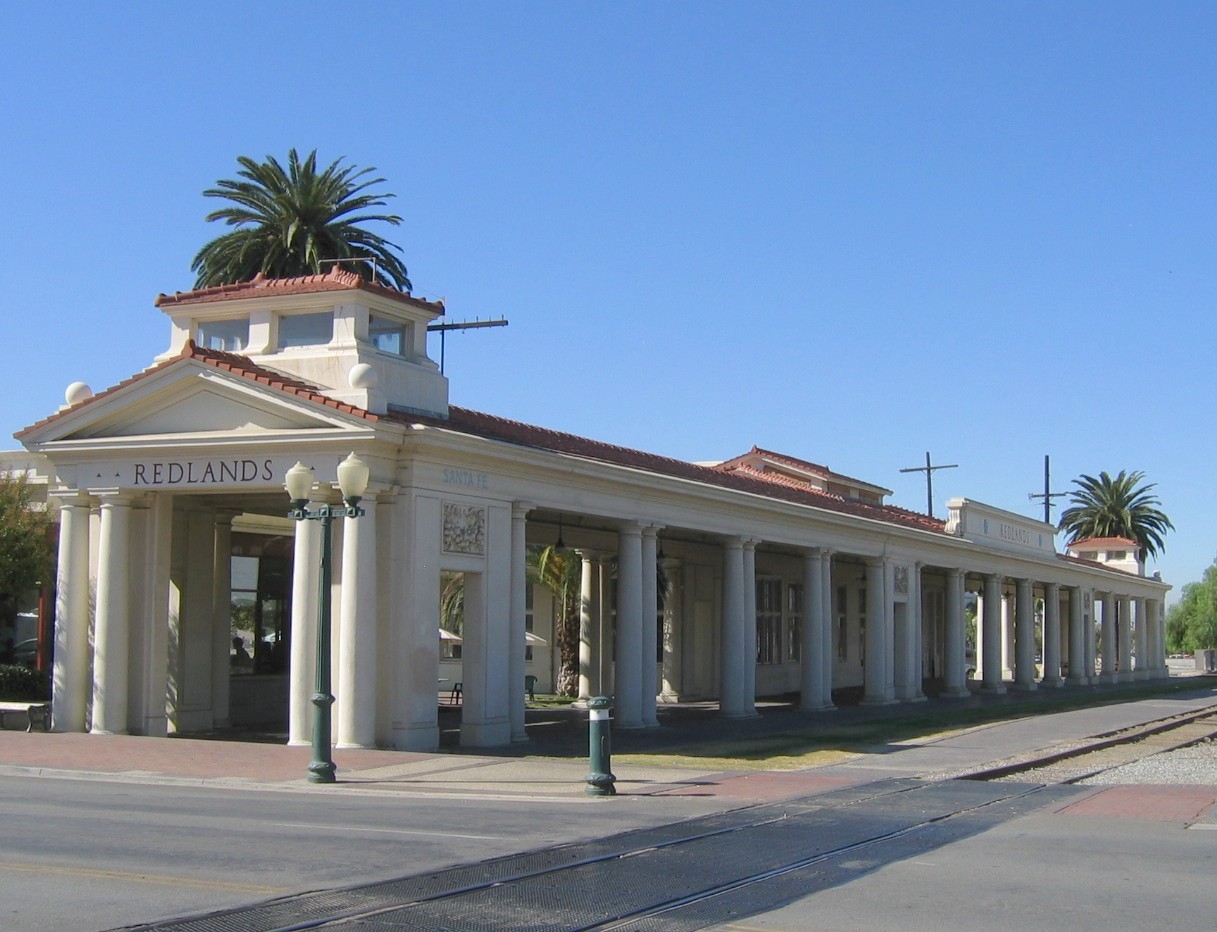
35°23′21″N 116°51′22″W / 35.389167°N 116.856111°WFort Irwin 43 Piute Pass Archeological District August 14, 1973 Address Restricted Needles 44 John Rains House April 24, 1973 7869 Vineyard Ave.
34°06′40″N 117°36′36″W / 34.111111°N 117.61°WRancho Cucamonga 45 Redlands Central Railway Company Car Barn January 3, 1991 746 E. Citrus Ave.
34°03′24″N 117°10′29″W / 34.056667°N 117.174722°WRedlands 46 Redlands Santa Fe Depot District 
October 29, 1991 Roughly bounded by Stuart Ave., N. 5th St., Redlands Blvd., Eureka St. and the SFRR tracks
34°03′31″N 117°10′57″W / 34.058611°N 117.1825°WRedlands 47 Rodman Mountains Petroglyphs Archeological District May 10, 1982 Address Restricted Barstow 48 Russian Village District 
December 28, 1978 290-370 S. Mills Ave. and 480 Cucamonga Ave.
34°05′29″N 117°42′24″W / 34.091389°N 117.706667°WMontclair 49 San Bernardino County Court House January 12, 1998 351 N. Arrowhead Ave.
34°06′20″N 117°17′26″W / 34.105556°N 117.290556°WSan Bernardino 50 Shady Point October 5, 2009 778 Shelter Cove Dr.
34°15′46″N 117°11′00″W / 34.262647°N 117.183225°WLake Arrowhead 51 Smiley Park Historic District December 29, 1994 Roughly bounded by Brookside Ave., Cajon St., Cypress Ave. and Buena Vista St.
34°03′03″N 117°10′56″W / 34.050833°N 117.182222°WRedlands 52 Squaw Spring Archeological District July 28, 1981 Address Restricted Red Mountain 53 Topock Maze Archeological Site October 5, 1978 Address Restricted Needles 54 Upland Public Library 
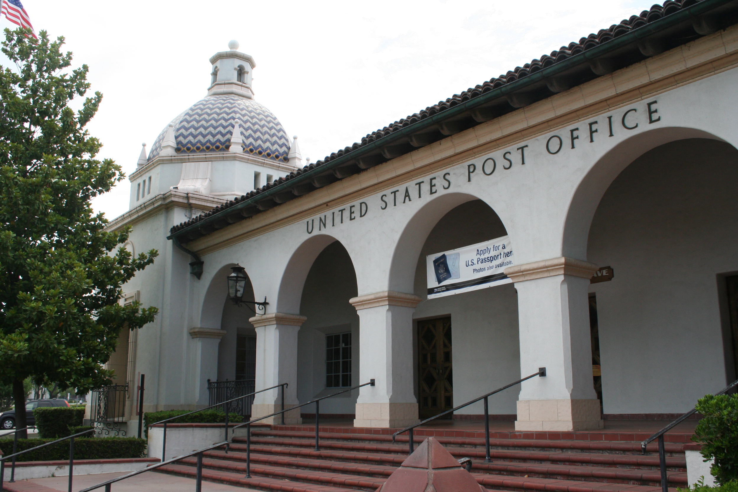
December 10, 1990 123 E. D St.
34°05′55″N 117°38′55″W / 34.098611°N 117.648611°WUpland 55 US Post Office-Downtown Station January 11, 1985 390 W. 5th St.
34°06′31″N 117°17′26″W / 34.108611°N 117.290556°WSan Bernardino 56 US Post Office-Redlands Main 
January 11, 1985 201 Brookside Ave.
34°03′18″N 117°11′05″W / 34.055°N 117.184722°WRedlands 57 Wall Street Mill 
November 12, 1975 S of Twentynine Palms in Joshua Tree National Park
34°02′10″N 116°07′59″W / 34.036111°N 116.133056°WTwentynine Palms 58 Henry Washington Survey Marker May 12, 1975 S of Big Bear City in San Bernadino National Forest
34°07′13″N 116°55′46″W / 34.120278°N 116.929444°WBig Bear City 59 Yorba-Slaughter Adobe July 7, 1975 5.5 mi. S of Chino at 17127 Pomona Rincon Rd.
33°56′26″N 117°39′52″W / 33.940556°N 117.664444°WChino See also
- National Register of Historic Places listings in California
- List of National Historic Landmarks in California
References
- ^ The latitude and longitude information provided in this table was derived originally from the National Register Information System, which has been found to be fairly accurate for about 99% of listings. For about 1% of NRIS original coordinates, experience has shown that one or both coordinates are typos or otherwise extremely far off; some corrections may have been made. A more subtle problem causes many locations to be off by up to 150 yards, depending on location in the country: most NRIS coordinates were derived from tracing out latitude and longitudes off of USGS topographical quadrant maps created under North American Datum of 1927, which differs from the current, highly accurate GPS system used by Google maps. Chicago is about right, but NRIS longitudes in Washington are higher by about 4.5 seconds, and are lower by about 2.0 seconds in Maine. Latitudes differ by about 1.0 second in Florida. Some locations in this table may have been corrected to current GPS standards.
- ^ "National Register of Historic Places: Weekly List Actions". National Park Service, United States Department of the Interior. Retrieved on November 10, 2011.
- ^ Numbers represent an ordering by significant words. Various colorings, defined here, differentiate National Historic Landmark sites and National Register of Historic Places Districts from other NRHP buildings, structures, sites or objects.
- ^ "National Register Information System". National Register of Historic Places. National Park Service. . http://nrhp.focus.nps.gov/natreg/docs/All_Data.html.
U.S. National Register of Historic Places Topics Lists by states Alabama • Alaska • Arizona • Arkansas • California • Colorado • Connecticut • Delaware • Florida • Georgia • Hawaii • Idaho • Illinois • Indiana • Iowa • Kansas • Kentucky • Louisiana • Maine • Maryland • Massachusetts • Michigan • Minnesota • Mississippi • Missouri • Montana • Nebraska • Nevada • New Hampshire • New Jersey • New Mexico • New York • North Carolina • North Dakota • Ohio • Oklahoma • Oregon • Pennsylvania • Rhode Island • South Carolina • South Dakota • Tennessee • Texas • Utah • Vermont • Virginia • Washington • West Virginia • Wisconsin • WyomingLists by territories Lists by associated states Other  Category:National Register of Historic Places •
  Portal:National Register of Historic PlacesCategories:
- History of San Bernardino County, California
- San Bernardino County, California
- National Register of Historic Places in California by county
- Lists of National Register of Historic Places in California
-


Wikimedia Foundation. 2010.