- Meager Creek
-
Meager Creek 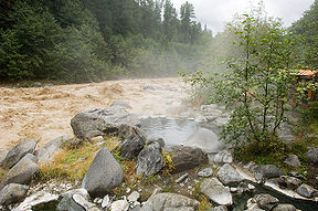
Meager Creek flowing next to a hot spring pool.Mouth Lillooet River Basin countries Canada Meager Creek is a creek in the southern Pacific Ranges of the Coast Mountains in British Columbia, Canada. It flows northeast into the Lillooet River.[1]
It is noted for a large set of surface hot springs, known as the Meager Creek Hot Springs, related to volcanism of the Mount Meager massif on its north side. Public access reopened in the summer of 2008 several years after vandalism of the site and flooding damage to the access road and bridge had seen the site closed. On September 19, 2009, the Capricorn Creek Bridge was once again destroyed by a debris slide[2]. The springs are once again closed to public access. The site (when open) is serviced by Creekside Resources and there is a fee to use the pools.
Avalanche hazards relating to the combined volcanic and glacial character of the surrounding geography are real and ongoing. The valley of Meager Creek is one of the most active and hazardous in the Canadian Cordillera.[3] Debris flows, mainly from the Mount Meager massif, have filled the valley to a depth of 250 m (820 ft).[citation needed]
Meager Creek is approximately 95 km (60 mi) northwest of the village of Pemberton.
See also
- List of British Columbia rivers
- Volcanism of Western Canada
References
- ^ "Meager Creek". BC Geographical Names. http://apps.gov.bc.ca/pub/bcgnws/names/21612.html.
- ^ "Mudslide closes Meager Creek FSR". Pique Newsmagazine. 2009. http://www.piquenewsmagazine.com/pique/index.php?cat=C_News&content=Meager+closed+1640. Retrieved 2009-10-02.
- ^ "The July 29, 1998, debris flow and landslide dam at Capricorn Creek, Mount Meager Volcanic Complex, southern Coast Mountains, British Columbia". Natural Resources Canada. 2000. http://article.pubs.nrc-cnrc.gc.ca/RPAS/rpv?hm=HInit&afpf=e00-042.pdf&journal=cjes&volume=37. Retrieved 2009-01-17.
Coordinates: 50°36′50″N 123°23′30″W / 50.61389°N 123.39167°W
Categories:- Rivers of British Columbia
- Hot springs of British Columbia
- Pemberton Valley
- Volcanism of British Columbia
- Natural hazards in British Columbia
- Pacific Ranges
- Holocene volcanism
- British Columbia Interior geography stubs

Wikimedia Foundation. 2010.