- 2000–01 Australian region cyclone season
-
2000–01 Australian region cyclone season 
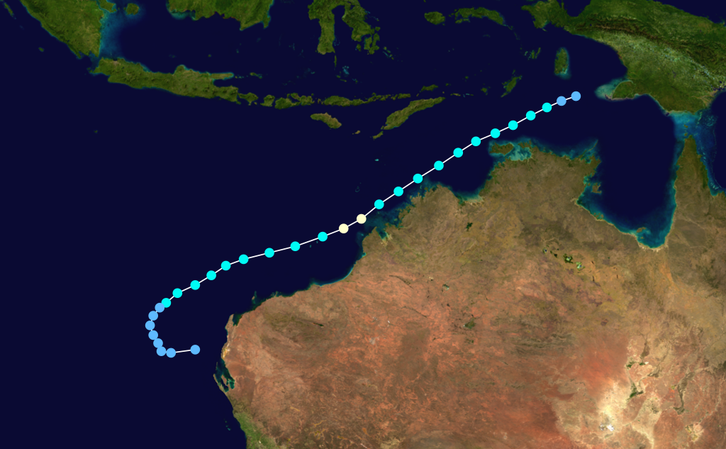
Season summary mapFirst storm formed: 4 December 2000 Last storm dissipated: 23 April 2001 Strongest storm: Sam – 935 hPa (mbar), 180 km/h (110 mph) (10-minute sustained) Total storms: 8 official, 1 unofficial Tropical cyclones: 3 Total fatalities: 163 total Total damage: $12.8 million (2001 USD) Australian region cyclone seasons
1998–99, 1999–00, 2000–01, 2001–02, 2002–03Related articles: The 2000–01 Australian region cyclone season was an event in the ongoing cycle of tropical cyclone formation. It began on 1 November 2000 and ended on 30 April 2001. The regional tropical cyclone operational plan also defines a tropical cyclone year separately from a tropical cyclone season, which runs from 1 July 2000 to 30 June 2001.
Tropical cyclones in this area are monitored by four Tropical Cyclone Warning Centres (TCWCs): the Australian Bureau of Meteorology in Perth, Darwin, and Brisbane; and TCWC Port Moresby in Papua New Guinea.[1]
Contents
Storms
Severe Tropical Cyclone Sam
Category 4 severe tropical cyclone (Australian scale) Category 3 tropical cyclone (SSHS) 

Duration 2 December – 10 December Intensity 175 km/h (110 mph) (10-min), 935 mbar (hPa) Cyclone Sam was an intense Category 3 cyclone that did heavy damage cross northwestern Australia. The cyclone damaged a train station and knocked down trees.[2] Operationally, the Bureau of Meteorology considered Sam to have been a Category 5 cyclone; however, post-storm analysis indicated that winds peaked at 195 km/h (120 mph), ranking the storm as a high-end Category 4.[3]
Offshore, two boats carrying a total of 167 illegal immigrants sank off the coast of Australia amidst rough seas produced by Sam. Officials confirmed the deaths of 163 of these after only four people were rescued by a Japanese tanker ship.[4] The large loss of life ranked Sam as the second-deadliest tropical cyclone in Australian history.[5]
Tropical Cyclone Terri
Category 2 tropical cyclone (Australian scale) Tropical storm (SSHS) 

Duration 28 January – 31 January Intensity 110 km/h (70 mph) (10-min), 975 mbar (hPa) Terri formed on 28 January 2001 near the northern Kimberley coast. The storm paralleled the coast, reaching Category 2 strength before making landfall near Pardoo early on 31 January. The storm dissipated Late on the same day.[6]
Tropical Cyclone Winsome
Category 1 tropical cyclone (Australian scale) Tropical storm (SSHS) 
Duration 9 February – 13 February Intensity 75 km/h (45 mph) (10-min), 981 mbar (hPa) Winsome was a weak system that developed from a low in the Gulf of Carpentaria on 8 February.
Torrential rains produced by the storm in the Northern Territory resulted in severe flooding which killed two people.[7]
Tropical Cyclone Vincent
Category 2 tropical cyclone (Australian scale) Tropical storm (SSHS) 
Duration 12 February – 15 February Intensity 100 km/h (65 mph) (10-min), 980 mbar (hPa) Cyclone Vincent formed on 12 February 2001, 900 km northwest of Onslow, Western Australia from an active monsoonal trough. Wind shear prevented the tropical low from intensifying for a few days, but once the storm formed it began to move southeast and intensify. Soon it intensified into a Category 2 cyclone. Wind shear soon became stronger and Cyclone Vincent weakened to a Category 1 cyclone. Cyclone Vincent crossed the Western Australia coast as a tropical low, a few km south of Broome, Western Australia.
Tropical Cyclone Wylva
Category 1 tropical cyclone (Australian scale) 
Duration 14 February – 16 February Intensity 75 km/h (45 mph) (10-min), 990 mbar (hPa) Tropical Cyclone Wylva hit the coast of Australia in February 2001. Although it was a weak Category 1 cyclone when it peaked in strength, it caused heavy damage when it made landfall. Heavy rain produced a record-breaking flood, which washed down the Victoria River[citation needed]. Damages were worth $13 million dollars and 700 people were evacuated from the dangerous flood waters.[citation needed]
Tropical Low (10P)
Tropical low (Australian scale) Tropical storm (SSHS) 
Duration 16 February – 16 February Intensity 55 km/h (35 mph) (10-min), 1000 mbar (hPa) This storm moved from Brisbane's area of responsibility into Fiji's on 16 February. It dissipated on the 18th.
Severe Tropical Cyclone Abigail
Category 3 severe tropical cyclone (Australian scale) Tropical storm (SSHS) 
Duration 24 February – 27 February Intensity 120 km/h (75 mph) (10-min), 970 mbar (hPa) On 24 February 2001, Cyclone Abigail formed about 80 km northeast of Cairns, Australia. It then made landfall in Queensland as a Category 1 storm.
Severe Tropical Cyclone Walter
Category 3 severe tropical cyclone (Australian scale) Category 2 tropical cyclone (SSHS) 
Duration 1 April – 8 April Intensity 150 km/h (90 mph) (10-min), 950 mbar (hPa) Walter was a storm that formed east of Christmas Island and tracked westward at a low latitude.
On 3 April, Cocos Island was placed under a cyclone watch as Walter approached the island.[8] Throughout 5 April, heavy rains and high winds, estimated up to 90 km/h (56 mph) battered the area as Walter bypassed the island.[9]
Tropical Cyclone Alistair
Category 2 tropical cyclone (Australian scale) Category 1 tropical cyclone (SSHS) 
Duration 16 April – 23 April Intensity 110 km/h (70 mph) (10-min), 975 mbar (hPa) The second most damaging cyclone of the 2000-01 Cyclone season, Alistair made landfall close to Carnarvon on 24 April 2001 as a poorly organized cyclone. The centre passed just to the north of town with a wind gust to 67 kilometres per hour from the northeast recorded at 4:11 am. Minimum pressure of 1002.9 hPa was recorded at 5 am, followed by the peak recorded wind gust of 90 kilometres per hour from the southeast at 6 am. A total of 24 mm of rainfall was reported in Carnarvon. Plantations to the north of Carnarvon reported 30-40 % crop losses, with wind estimates of 100 to 110 kilometres per hour. [1]
Storm names
Tropical cyclones are assigned names by the Australian Bureau of Meteorology or Papua New Guinea.
Tropical cyclones are named if they are non-frontal low pressure systems of synoptic scale developing over warm waters, or Dvorak intensity analysis indicate the presence of gale force or stronger winds near the centre. Therefore, a tropical system with gales in one or more quadrants, but not near the centre, are not named.[10]
All names assigned in the Australian region are used sequentially, unlike lists used annually by the National Hurricane Centre in the Atlantic Ocean and east Pacific Ocean. Only the names used during this cyclone season are listed below. The complete list of names for each basin are found in the World Meteorological Organization's official list.
Southeast Indian Ocean
Tropical cyclones that develop east of 90°E, south of the Equator, and west of 125°E are assigned names by the Tropical Cyclone Warning Centre in Perth, Western Australia.[1]
- Sam
- Terri
- Vincent
- Walter
Arafura Sea and Western Gulf of Carpentaria
Tropical cyclones that develop south of the Equator between 125°E and 141°E are assigned names by the Tropical Cyclone Warning Centre in Darwin, Northern Territory.[1]
- Winsome
- Alistair
Coral Sea and Eastern Gulf of Carpentaria
Tropical cyclones that develop south of 10°S between 141°E and 160°E are assigned names by the Tropical Cyclone Warning Centre in Brisbane, Queensland.[1]
- Wylva
- Abigail
Solomon Sea and Gulf of Papua
Tropical cyclones that develop north of 10°S between 141°E and 160°E are assigned names by the Tropical Cyclone Warning Centre in Port Moresby, Papua New Guinea.[1]
No tropical cyclone names were used in the 2000-01 season.
See also
- List of Southern Hemisphere tropical cyclone seasons
- Atlantic hurricane seasons: 2000, 2001
- Pacific hurricane seasons: 2000, 2001
- Pacific typhoon seasons: 2000, 2001
- North Indian Ocean cyclone seasons: 2000, 2001
References
- ^ a b c d e http://www.wmo.ch/web/www/TCP/TCP24-English2004.pdf
- ^ "Season 2000-2001 Tropical Cyclone SAM Track Map". http://australiasevereweather.com/tropical_cyclones/2000_2001/oper/tropical_cyclone_sam.htm. Retrieved 19 October 2010.
- ^ "Sam starts to weaken". The Advertiser. 11 December 2010.
- ^ Ansley, Greg (15 December 2000). "Shipwreck inaction 'callous'". The New Zealand Herald. http://www.nzherald.co.nz/world/news/article.cfm?c_id=2&objectid=165212. Retrieved 14 September 2011.
- ^ "Sam Behind Deaths". The Daily Telegraph. 15 December 2001.
- ^ "Season 2000-2001 Tropical Cyclone TERRI Track Map". australiasevereweather.com. http://australiasevereweather.com/tropical_cyclones/2000_2001/oper/tropical_cyclone_terri.htm. Retrieved 19 October 2010.
- ^ James Wakelin and Alice Burton (14 February 2001). "Storm chaos: 2 feared dead; High winds lash Top End". Northern Territory News.
- ^ "Cocos Cyclone". The Advertiser: p. 34. 4 April 2001.
- ^ "Cyclone Walter hits Cocos". The Daily Telegraph: p. 17. 6 April 2001.
- ^ http://www.wmo.ch/web/www/TCP/OperationPlans/TCP24-English2004.pdf
External links
- Joint Typhoon Warning Center (JTWC).
- Australian Government Bureau of Meteorology.
- World Meteorological Organization
- WMO Annual Summary of Global Tropical Cyclone Seasons 2000
- WMO Annual Summary of Global Tropical Cyclone Seasons 2001
- Joint Typhoon Warning Center 1999 ATCR
- Raw cyclone track data
- BoM Monthly Significant Weather Summaries
- July 2000 to June 2001 Tropical Cyclone Summaries and Operational Track Data
- Gary Padgett's Southern Hemisphere 2000-2001 Tropical Cyclone Season Review
2000–09 Australian region cyclone seasons


Wikimedia Foundation. 2010.