- Cape Verde
-
This article is about the country. For the surface feature on Mars, see Cape Verde (Mars). For weather pattern, see Cape Verde-type hurricane.
Republic of Cape Verde República de Cabo Verde (Portuguese)

Flag National emblem Anthem: Cântico da Liberdade (Portuguese)
Song of Freedom
Capital
(and largest city)Praia
14°55′N 23°31′W / 14.917°N 23.517°WOfficial language(s) Portuguese Recognised regional languages Cape Verdean Creole Demonym Cape Verdean Government Parliamentary republic - President Jorge Carlos Fonseca - Prime Minister José Maria Neves Independence - from Portugal July 5, 1975 Area - Total 4,033 km2 (172nd)
1,557 sq mi- Water (%) negligible Population - 2010 estimate 567,000[1] (165th) - 2009 census 509,000[2] - Density 125.5/km2 (79th)
325.0/sq miGDP (PPP) 2011 estimate - Total $2.035 billion[3] - Per capita $3,783[3] GDP (nominal) 2011 estimate - Total $1.867 billion[3] - Per capita $3,469[3] HDI (2011)  0.568[4] (medium) (133st)
Currency Cape Verdean escudo ( CVE)Time zone CVT (UTC-1) - Summer (DST) not observed (UTC-1) Drives on the right ISO 3166 code CV Internet TLD .cv Calling code +238 The Republic of Cape Verde
 i/ˌkeɪp ˈvɜrd/ (Portuguese: Cabo Verde, pronounced: [ˈkabu ˈveɾdɨ]) is an island country, spanning an archipelago of 10 islands located in the central Atlantic Ocean, 570 kilometres off the coast of Western Africa. The islands, covering a combined area of slightly over 4,000 square kilometres (1,500 sq mi), are of volcanic origin and while three of them (Sal, Boa Vista and Maio) are fairly flat, sandy and dry, the remaining ones are generally rockier and have more vegetation. However, because of the infrequent occurrence of rainfall the overall landscape is not particularly green, despite what the country's name suggests (verde is Portuguese for "green"). The name of the country stems instead from the nearby Cap Vert, on the Senegalese coast,[5] which in its turn was originally named "Cabo Verde" when it was sighted by Portuguese explorers in 1444, a few years before the islands were discovered.
The previously uninhabited islands were discovered and colonized by the Portuguese in the 15th Century, and became an important location in the Atlantic slave trade due to their geographically advantageous position. The islands' prosperity often attracted pirates, including Sir Francis Drake, a corsair under the British crown, who twice sacked the (then) capital Ribeira Grande, in the 1580s. The islands were also visited by Charles Darwin's expedition in 1832. The decline in the slave trade in the 19th century resulted in an economic crisis for the islands. With few natural resources, and without strong sustainable investment from the Portuguese, the citizens grew increasingly discontent with the colonial masters, who nevertheless refused to provide the local authorities with more autonomy. This discontent festered and culminated in 1975, when a movement led by Amílcar Cabral achieved independence for the archipelago.
The country has an estimated population (most of creole ethnicity) of about 500,000, with its capital city Praia accounting for a quarter of its citizens. Nearly 38% of the population lives in rural areas according to the 2010 Cape Verdean census; about 20% lives below the poverty threshold,[6] and the literacy rate is around 85%. Politically, the country is a very stable democracy, with notable economic growth and improvements of living conditions despite its lack of natural resources, and has garnered international recognition by other countries and international organizations, which often provide development aid. Since 2007, Cape Verde has been classified as a developing nation.
Tough economic times during the last decades of its colonization and the first years of Cape Verde's independence led many to migrate to Europe, the Americas and other African countries. This migration was so significant that the number of Cape Verdeans and their descendants living abroad currently exceeds the population of Cape Verde itself. Historically, the influx of remittances from these immigrant communities to their families has provided a substantial contribution to help strengthen the country's economy. Currently, the Cape Verdean economy is mostly service-oriented with a growing focus on tourism and foreign investment, which benefits from the islands' warm climate throughout the year, diverse landscape, welcoming people and cultural richness, especially in music.
Contents
History
Main article: History of Cape Verde
 The Serra Malagueta mountain range in the northern part of the island of Santiago
 The sandy Viana desert on the island of Boa Vista
Before the arrival of Europeans, the Cape Verde Islands were uninhabited. The islands of the Cape Verde archipelago were discovered by Italian and Portuguese navigators around 1456. According to Portuguese official records [7] the first discoveries were made by Genoese born Antonio de Noli, who was afterwards appointed governor of Cape Verde by Portuguese King Afonso V. Other navigators mentioned as contributing with discoveries in the Cape Verde archipelago are Diogo Gomes, Diogo Dias, Diogo Afonso and the Italian Alvise Cadamosto.
In 1462, Portuguese settlers arrived at Santiago and founded a settlement they called Ribeira Grande (now called Cidade Velha, to avoid being confused with the town of Ribeira Grande on the Santo Antão island). Ribeira Grande was the first permanent European settlement in the tropics.[8]
In the 16th century, the archipelago prospered from the transatlantic slave trade.[8] Pirates occasionally attacked the Portuguese settlements. Sir Francis Drake, a British corsair, sacked Ribeira Grande in 1585.[8] After a French attack in 1712, the town declined in importance relative to nearby Praia, which became the capital in 1770.[8]
With the decline in the slave trade, Cape Verde's early prosperity slowly vanished. However, the islands' position astride mid-Atlantic shipping lanes made Cape Verde an ideal location for re-supplying ships. Because of its excellent harbour, Mindelo (on the island of São Vicente) became an important commercial centre during the 19th century.[8]
In 1951, Portugal changed Cape Verde's status from a colony to an overseas province in an attempt to blunt growing nationalism. In 1956, Amilcar Cabral, and a group of fellow Cape Verdeans and Guineans organised (in Portuguese Guinea) the clandestine African Party for the Independence of Guinea and Cape Verde (PAIGC), which demanded improvement in economic, social and political conditions in Cape Verde and Portuguese Guinea and formed the basis of the two nations' independence movement. Moving its headquarters to Conakry, Guinea in 1960, the PAIGC began an armed rebellion against Portugal in 1961. Acts of sabotage eventually grew into a war in Portuguese Guinea that pitted 10,000 Soviet bloc-supported PAIGC soldiers against 35,000 Portuguese and African troops.[8]
By 1972, the PAIGC controlled much of Portuguese Guinea despite the presence of the Portuguese troops, but the organization did not attempt to disrupt Portuguese control in Cape Verde. Portuguese Guinea declared independence in 1973 and was granted de jure independence in 1974. Following the April 1974 revolution in Portugal, the PAIGC became an active political movement in Cape Verde. In December 1974, the PAIGC and Portugal signed an agreement providing for a transitional government composed of Portuguese and Cape Verdeans. On June 30, 1975, Cape Verdeans elected a National Assembly which received the instruments of independence from Portugal on July 5, 1975.[8]
Immediately following the November 1980 coup in Guinea-Bissau, relations between Cape Verde and Guinea-Bissau became strained. Cape Verde abandoned its hope for unity with Guinea-Bissau and formed the African Party for the Independence of Cape Verde (PAICV). Problems have since been resolved and relations between the countries are good. The PAICV and its predecessor established a one-party system and ruled Cape Verde from independence until 1990.[8]
Responding to growing pressure for pluralistic democracy, the PAICV called an emergency congress in February 1990 to discuss proposed constitutional changes to end one-party rule. Opposition groups came together to form the Movement for Democracy (MPD) in Praia in April 1990. Together, they campaigned for the right to contest the presidential election scheduled for December 1990.
The one-party state was abolished September 28, 1990, and the first multi-party elections were held in January 1991. The MPD won a majority of the seats in the National Assembly, and MPD presidential candidate António Mascarenhas Monteiro defeated the PAICV's candidate with 73.5% of the votes. Legislative elections in December 1995 increased the MPD majority in the National Assembly. The party won 50 of the National Assembly's 72 seats.
A February 1996 presidential election returned President Monteiro to office. Legislative elections in January 2001 returned power to the PAICV, with the PAICV holding 40 of the National Assembly seats, MPD 30, and Party for Democratic Convergence (PCD) and Party for Labor and Solidarity (PTS) 1 each. In February 2001, the PAICV-supported presidential candidate Pedro Pires defeated former MPD leader Carlos Veiga by only 13 votes.[8]
Geography
Main article: Geography of Cape VerdePraia Climate chart (explanation) J F M A M J J A S O N D 3252002519026200262102721028225282497292411429253129248282332622Average max. and min. temperatures in °C Precipitation totals in mm Source: BBC Weather[9] Imperial conversion J F M A M J J A S O N D 0.1776807766079680797008170082720.282753.884754.584771.284750.382730.17972Average max. and min. temperatures in °F Precipitation totals in inches  The beach of Calhau, with Monte Verde in the background, on the island of São Vicente
 The summit of Pico do Fogo, the highest peak in the Cape Verde archipelago, located on the island of Fogo
 Terra satellite took this photo of Cape Verde islands on November 23, 2010.
The Cape Verde archipelago is located in the Atlantic Ocean, approximately 570 kilometres (350 mi) off the coast of West Africa, near Mauritania and Senegal, and is part of the Macaronesia ecoregion. It lies between latitudes 14° and 18°N, and longitudes 22° and 26°W.
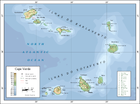
The country is a horseshoe-shaped cluster of ten islands (nine inhabited) and eight islets,[10] that constitute an area of 4033 km².[10]
The islands are spatially divided into two groups:
- The Ilhas de Barlavento (English: windward islands): Santo Antão, São Vicente, Santa Luzia, São Nicolau, Sal, Boa Vista;[10] and
- The Ilhas de Sotavento (English: leeward islands): Maio, Santiago, Fogo, Brava.[10]
The largest island, both in size and population, is Santiago, which hosts the nation's capital, Praia, the principal agglomeration in the archipelago.[10]
Physical geography
Magnetic anomalies identified in the vicinity of the archipelago indicate that the structures forming the islands date back 125-150 million years: the islands themselves date from 8 million (in the west) to 20 million years (in the east).[11] The oldest exposed rocks occurred on Maio and northern peninsula of Santiago and are 128-131 million year old pillow lavas. The first stage of volcanism in the islands began in the early Miocene, and reached its peak at the end of this period, when the islands reached their maximum sizes. Historical volcanism (within human settlement) has been restricted to the island of Fogo.
The origin of the islands' volcanism has been attributed to a hotspot, associated with bathymetric swell that formed the Cape Verde Rise.[12] The Rise is one of the largest protuberances in the world's oceans, rising 2.2 kilometers in a semi-circular region of 1200 km², associated with a rise of the geoid and elevated surface heat flow.[11]
Though Cape Verde's islands are all volcanic in origin, they vary widely in terrain.[10]
Most recently erupting in 1995, Pico do Fogo is the largest active volcano in the region. It has a 8 km (5 mi) diameter caldera, whose rim is 1,600 m (5,249 ft) altitude and an interior cone that rises to 2,829 m (9,281 ft) above sea level. The caldera resulted from subsidence, following the partial evacuation (eruption) of the magma chamber, along a cylindrical column from within magma chamber (at a depth of 8 km (5 mi)).
Geologically, the islands are principally composed of igneous rocks, with volcanic structures and pyroclastic debris comprising the majority of the archipelago's total volume. The volcanic and plutonic rocks are distinctly basic; the archipelago is a soda-alkaline petrographic province, with a petrologic succession which is similar to that found in other Macaronesian islands.
Extensive salt flats are found on Sal and Maio.[10] On Santiago, Santo Antão, and São Nicolau, arid slopes give way in places to sugarcane fields or banana plantations spread along the base of towering mountains.[10]
Climate
Main article: Climate of Cape VerdeCape Verde's climate is milder than that of the African mainland because the surrounding sea moderates temperatures on the islands.[10] Average daily high temperatures range from 25 °C (77 °F) in January to 29 °C (84.2 °F) in September.[9] Cape Verde is part of the Sahelian arid belt, with nothing like the rainfall levels of nearby West Africa.[10] It does rain irregularly between August and October, with frequent brief-but-heavy downpours.[10] A desert is usually defined as terrain which receives less than 250 mm (9.8 in) of annual rainfall. Cape Verde's total (261 mm/10.3 in) is slightly above this criterion, which makes the area climate semi-desert.
The islands, covering a combined area of slightly over 4,000 square kilometres (1,500 sq mi), are of volcanic origin and while three of them (Sal, Boa Vista and Maio) are fairly flat, sandy and dry, the remaining ones are generally rockier and have more vegetation. However, because of the infrequent occurrence of rainfall the overall landscape is not particularly green. However, the archipelago can be divided into four broad ecological zones: arid, semiarid, subhumid and humid, according to altitude and average annual rainfall ranging from 200 mm in the arid areas of the coast to more than 1000 mm in the humid mountain. Mostly rainfall precipitation is due to condensation of the ocean mist.
In some islands, as Santiago, the wetter climate of the interior and the eastern coast contrasts with the dryer one in the south/southwest coast. Praia, located in the southeast coast, is the largest city of the island, and also the largest city and capital of the country.
The Cape Verde islands are a very degradated area. Due to its proximity to the Sahara, most of the Cape Verde islands are dry, but on islands with high mountains and farther away from the coast, by orography, the humidity is much higher, giving a rainforest habitat, very degraded by the strong human presence. Northeastern slopes of high mountains often receive a lot of rain and Southwest slopes not. This umbria areas are identified with cool and moisture. Some islands, with steep mountains, are covered with vegetation where the dense ocean moisture condense and soak the plants, rocks, soil, logs, moss etc.
cloud forests developed about mountains, where the dense moisture from the sea or ocean, is precipitated by the action of the relief. Opposing the terrain to a front of warm, moist air mass, it forces to increase the height above sea level of that body wet and warm air mass, which cools and decreases the dew point, causing it to condense part of the moisture that falls as rain or fog, creating an habitat especially cool, saturated with moisture in the air and soil.
Hurricanes that form near the Cape Verde Islands are sometimes referred to as Cape Verde-type hurricanes. These hurricanes can become very intense as they cross warm Atlantic waters.
Biome
Cape Verde's isolation has resulted in the islands having a number of endemic species, particularly bird and reptiles, many of which are endangered by human development. Endemic birds include Alexander's Swift (Apus alexandri), Bourne's Heron (Ardea purpurea bournei), the Raso Lark (Alauda razae), the Cape Verde Warbler (Acrocephalus brevipennis), and the Iago Sparrow (Passer iagoensis).[13] The islands are also an important breeding area for seabirds including the Cape Verde Shearwater. Reptiles include the Cape Verde Giant Gecko (Tarentola gigas).
Human geography
Main article: Administrative divisions of Cape Verde Vista of Nova Sintra, the municipal seat of Brava
Cape Verde is divided into 22 municipalities (concelhos) and subdivided into 32 parishes (freguesias), based on the religious parishes that existed during the colonial period:
 View of downtown Mindelo en Baía do Porto Grande, São Vicente
 The uninhabited islets Ilhéus Secos or Ilhéus do Rombo as seen from off the coast, with the town of Nova Sintra in the foreground
Demographics
Main article: Demographics of Cape Verde Population pyramid (demographics) showing age distribution of males to females (2005)
Most of the population is of creole ethnicity, mixed from black African and European descent. The European men who colonized Cape Verde did not usually bring wives or families with them. As female African slaves were brought to the islands inter-marriages occurred.[10]
A genetic study revealed that the ancestry of the population in Cape Verde is 57% African and 43% European.[14]
Around 95% of the population is Christian (more than 85 percent of the population is nominally Roman Catholic,[15] though for a minority of the population Catholicism is syncretized with African influences).[2] The largest Protestant denomination is the Church of the Nazarene; other groups include the Seventh-day Adventist Church, the Church of Jesus Christ of Latter-day Saints, the Assemblies of God, the Universal Church of the Kingdom of God, and various other Pentecostal and evangelical groups.)[15] There are small Baha'i communities and a small Muslim community.[15] The number of atheists is estimated at less than 1 percent of the population.[15]
Cape Verde's official language is Portuguese. It is the language of instruction and government. However, the Cape Verdean Creole is used colloquially and is the mother tongue of virtually all Cape Verdeans. Cape Verdean Creole or Kriolu is a dialect continuum of a Portuguese-based creole, which varies from island to island. There is a substantial body of literature in Creole, especially in the Santiago Creole and the São Vicente Creole. Creole has been gaining prestige since the nation's independence from Portugal. However, the differences between the varied forms of the language within the islands have been a major obstacle in the way of standardization of the language. Some people have advocated the development of two standards: a North (Barlavento) standard, centered on the São Vicente Creole, and a South (Sotavento) standard, centered on the Santiago Creole. Manuel Veiga, PhD, a linguist by training, and Minister of Culture of Cape Verde, is the premier proponent of Kriolu's officialization and standardization. The demographic statistics site ESA says Cape Verde has a population of 567,000 in 2010.
Emigration
Main article: Cape Verdean diaspora Local women on the island of Santiago
Today, more Cape Verdeans live abroad than in Cape Verde itself, with significant emigrant[16] Cape Verdean communities in the United States (500,000 Cape Verdeans descent, with a major concentration on the New England coast from Providence, Rhode Island, to New Bedford, Massachusetts). There are also significant Cape Verde populations in Portugal (150,000), Angola (45,000), São Tomé and Príncipe (25,000), Senegal (25,000), the Netherlands (20,000, of which 15,000 are concentrated in Rotterdam), France (25,000), Scandinavia (7,000), Italy (10,000) and Spain (12,500). There is also a Cape Verdean community in Argentina numbering 8,000. A large number of Cape Verdeans and people of Cape Verdean descent that immigrated before 1975 are not included in these statistics, because all the Cape Verdeans had Portuguese passports before 1975.
There are approximately 2,000 Chinese immigrants in Cape Verde, as well as citizens of the African mainland (most of these immigrants hail from West Africa), there are also a significant number of citizens of Europe and South America (Brazil) residing in the country. There are an estimated 20,000 immigrants in Cape Verde of which 14,000 are legal residents.
In the USA, the children and grandchildren of the first immigrant waves became involved in the Civil Rights movement of the 1960s. This led them to make links with other US black groups. Cape-Verdean Americans have also been involved in the US Army for centuries; in the Revolutionary War, Civil War, the First and Second World Wars, as well as the Korean and Vietnam Wars.[17] Cape Verdeans moved to places all over the world, from Macau to Haiti to Argentina to northern Europe.[18]
Politics
 Main article: Politics of Cape Verde
Cape Verde is a stable representative Parliamentary republic.[19] The constitution —adopted in 1980 and revised in 1992, 1995 and 1999— defines the basic principles of its government. The president is the head of state and is elected by popular vote for a 5-year term. The prime minister is the head of government and proposes other ministers and secretaries of state. The prime minister is nominated by the National Assembly and appointed by the president. Members of the National Assembly are elected by popular vote for 5-year terms. Three parties now hold seats in the National Assembly—PAICV 40, MPD 30, and Cape Verdean Independent Democratic Union (UCID) 2.[8]
The judicial system consists of a Supreme Court of Justice — whose members are appointed by the president, the National Assembly, and the Board of the Judiciary — and regional courts. Separate courts hear civil, constitutional, and criminal cases. Appeal is to the Supreme Court.[8]
Cape Verde follows a policy of nonalignment and seeks cooperative relations with all friendly states.[8] Angola, Brazil, the People's Republic of China, Cuba, France, Germany, Portugal, Spain, Senegal, Russia and the United States maintain embassies in Praia.[8] Cape Verde is actively interested in foreign affairs, especially in Africa.[8] It has bilateral relations with some Lusophone nations and holds membership in a number of international organisations.[8] It also participates in most international conferences on economic and political issues.[8] Since 2007, Cape Verde has a special partnership status[20] with the EU, under the Cotonou Agreement, and might apply for special membership.[21]
The military of Cape Verde consists of a coast guard and an army; 0.7% of the country's GDP was spent on the military in 2005.
International recognition
Cape Verde is often praised as an example among African nations, for its stability and developmental growth despite its lack of natural resources. Among others, it has been recognized with the following assessments:
Index Score PALOP rank CPLP rank African rank World rank Year Human Development Index 0.568 1 (top 17%) 3 (top 38%) 10 (top 19%)[note 1] 133 (top 66%) 2011[4] Ibrahim Index of African Governance 75.5 1 (top 17%) N/A 2 (top 4%) N/A 2011[22] Freedom of the Press 28 (Free) 1 (top 17%) 2 (top 25%) 4 (top 8%) 60 (top 30%) 2009 Freedom in the World 1/1[note 2] 1 (top 17%) 1 (top 13%)[note 3] 1 (top 2%)[note 4] 1 (top 1%)[note 5] 2011 Press Freedom Index 8 1 (top 17%) 1 (top 13%) 2 (top 4%) 26 (top 13%) 2010 Democracy Index 7.94 (Flawed democracy) 1 (top 17%) 2 (top 25%) 2 (top 4%) 27 (top 14%) 2010 Corruption Perceptions Index 5.1 1 (top 17%) 2 (top 25%) 3 (top 6%) 45 (top 23%) 2010 Index of Economic Freedom[23] 64.6 1 (top 17%) 1 (top 13%) 3 (top 6%) 65 (top 32%) 2010 e-Government Readiness Index 0.4054 1 (top 17%) 3 (top 38%) 6 (top 12%) 108 (top 53%) 2010 Failed States Index 77.2 2 (top 34%) 3 (top 38%) 14 (top 26%) 89 (top 44%)[note 6] 2010 Networked Readiness Index 3.57 1 (top 17%) 3 (top 38%) 10 (top 19%) 84 (top 42%) 2011[24] - ^ See List of countries by Human Development Index#Africa
- ^ 1/1 is the highest possible rating.
- ^ Cape Verde was the only African country to reach the maximum rating.
- ^ The rank on this list is expressed in reverse order. To be comparable with the other rankings on this table, the actual rank of 88 was inverted, by subtracting it from the number of countries on the list, currently 177.
Moreover, on 10 October 2011 Cape Verde became the 119th state which ratified the Rome Statute of the International Criminal Court (Cape Verde becomes the 119th State to Join the Rome Statute System).
Economy
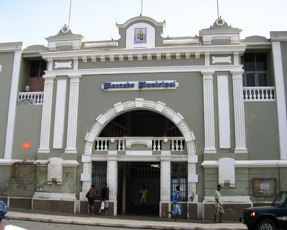
Main article: Economy of Cape Verde Municipal market in S. Vicente
Cape Verde has few natural resources, scant rainfall and limited supplies of fresh water.[citation needed] Only four of the ten main islands (Santiago, Santo Antão, Fogo, and Brava) normally support significant agricultural production,[30] and over 90% of all food consumed in Cape Verde is imported. Mineral resources include salt, pozzolana (a volcanic rock used in cement production), and limestone.[8] Its small number of wineries making Portuguese-style wines have traditionally focused on the domestic market, but have recently met with some international acclaim. A number of wine tours of Cape Verde's various microclimates began to be offered in spring 2010 and can be arranged through the tourism office.[31]
The economy of Cape Verde is service-oriented, with commerce, transport, and public services accounting for more than 70% of GDP.[citation needed] Although nearly 38% of the population lives in rural areas, agriculture and fishing contribute only about 9% of GDP. Light manufacturing accounts for most of the remainder. Fish and shellfish are plentiful, and small quantities are exported. Cape Verde has cold storage and freezing facilities and fish processing plants in Mindelo, Praia, and on Sal. Expatriate Cape Verdeans contribute an amount estimated at about 20% of GDP to the domestic economy through remittances.[8]
Since 1991, the government has pursued market-oriented economic policies, including an open welcome to foreign investors and a far-reaching privatization programme. It established as top development priorities the promotion of a market economy and of the private sector; the development of tourism, light manufacturing industries, and fisheries; and the development of transport, communications, and energy facilities. From 1994 to 2000 about $407 million in foreign investments were made or planned, of which 58% were in tourism,[32] 17% in industry, 4% in infrastructure, and 21% in fisheries and services.[8]
In 2011, on 4 islands a windfarm was built, that in total supplies about 25% of the electricity of the country. With this amount it is one of the top countries for renewable energy.[33]
Between 2000 and 2009, real GDP increased on average by over 7 percent a year, well above the average for Sub-Saharan countries and faster than most small island economies in the region. Strong economic performance was bolstered by one of the fastest growing tourism industries in the world, as well as by substantial capital inflows that allowed Cape Verde to build up national currency reserves to the current 3.5 months of imports. Unemployment has been falling rapidly, and the country is on track to achieve most of the UN Millenium Development Goals – including halving its 1990 poverty level.
In 2007, Cape Verde joined the World Trade Organization (WTO) and in 2008 the country graduated from Least Developed Country (LDC) to Middle Income Country (MIC) status.[34][35]
Cape Verde has significant cooperation with Portugal at every level of the economy, which has led it to link its currency first to the Portuguese escudo and, in 1999, to the euro. On June 23, 2008 Cape Verde became the 153rd member of the WTO.[36]
Development
The European Commission's total allocation for the period of 2008–2013 foreseen for Cape Verde to address "poverty reduction, in particular in rural and periurban areas where women are heading the households, as well as good governance" amounts to €54.1 million.[37]
Wildlife
Main article: Wildlife of Cape VerdeTourism
Main article: Tourism in Cape Verde The collection of sailing ships in Porto Grande, Mindelo on the island of São Vicente: tourism is a growing source of income on the islands
Cape Verde's strategic location at the crossroads of mid-Atlantic air and sea lanes has been enhanced by significant improvements at Mindelo's harbor (Porto Grande) and at Sal's and Praia's international airports. A new international airport was opened in Boa Vista in December 2007, and on the island of Sao Vicente, the newest international airport (Sao Pedro Airport) in Cape Verde, was opened in late 2009. Ship repair facilities at Mindelo were opened in 1983. The major ports are Mindelo and Praia, but all other islands have smaller port facilities. In addition to the international airport on Sal, airports have been built on all of the inhabited islands. All but the airport on Brava enjoy scheduled air service. The archipelago has 3,050 km (1,895 mi) of roads, of which 1,010 km (628 mi) are paved, most using cobblestone.[8]
The country's future economic prospects depend heavily on the maintenance of aid flows, the encouragement of tourism, remittances, outsourcing labor to neighboring African countries, and the momentum of the government's development program.[8]
Tourism has increased in recent years. Large hotels have been built across the country in an effort to boost tourism. In particular, on the islands of Boa Vista (Club Hotel Riu Karamboa (750 rooms)), and Sal (Club Hotel Riu Funana/Garopa (1000 rooms)--the largest hotel in all of West Africa). The Cape Verde islands have a relatively low crime rate and beautiful beaches, as well as having engaging local people. Tourists and leisure seekers from across Europe and the world are coming to the country in larger numbers.
In 2010, about 382,000 tourists visited the archipelago.
Transport
Main article: Transport in Cape VerdeCulture
Main articles: Culture of Cape Verde and Music of Cape Verde A group playing morna
Cape Verdean social and cultural patterns are similar to those of rural Portugal and Africa.[10] Soccer (Futebol) games and church activities are typical sources of social interaction and entertainment.[10] The traditional walk around the praça (town square) to meet friends is practiced regularly in Cape Verde towns.[10] In towns with electricity, television is available on two channels (Cape Verdean and Portuguese).[10]
Cape Verde music incorporates Portuguese, Caribbean, African, and Brazilian influences.[38] Cape Verde's quintessential national music is the morna, a melancholy and lyrical song form typically sung in Cape Verdean Creole. The most popular music genre after morna is the coladeira followed by funaná and batuque music. Amongst the most worldwide known Cape Verdean singers, are the singers Ildo Lobo and Cesaria Evora whose songs became a hallmark of the country and its culture. There are also well known artists born to Cape Verdean parents who excelled themselves. Amongst these artists are jazz pianist Horace Silver, Duke Ellington's saxophonist Paul Gonsalves and singer Lura.
Dance forms include the soft dance morna, the extreme sensuality of coladeira including the modernized version called passada (zouk), the Funaná (a sensual mixed Portuguese and African dance), and the Batuque dance.
Cape Verdean literature is one of the richest of Lusophone Africa. Famous poets include Paulino Vieira, Manuel de Novas, Sergio Frusoni, Eugénio Tavares, and B. Léza, and famous authors include Baltasar Lopes da Silva, António Aurélio Gonçalves, Manuel Lopes, Orlanda Amarílis, Henrique Teixeira de Sousa, and Germano Almeida.
Cuisine
The Cape Verde diet is mostly based on fish and staple foods like corn and rice. Vegetables available during most of the year are potatoes, onions, tomatoes, manioc, cabbage, kale, and dried beans. Fruits such as banana and papayas are available year-round, while others like mangos and avocados are seasonal.[10] A popular dish served in Cape Verde is Cachupa, a slow cooked stew of corn (hominy), beans, and fish or meat.
Health and education
Health
Main article: Health in Cape Verde Health Clinic in a residential area in Praia.
 Teachers' Training College in Praia.
The infant mortality rate in Cape Verde is 21 per 1,000 live births. The AIDS prevalence rate is 0.5%, the literacy rate is 85%, and 99% among Cape Verdean youth. The mean years of schooling of adults over 25 years is 7. Life expectancy in Cape Verde is 70.5 years for males and 77.7 years for females according to Cape Verdean statistics. [39] Cape Verde has been steadily developing[40] since its independence, and besides having been promoted to the group of "medium development" countries in 2007, leaving the Least Developed Countries category (which is only the second time it has happened to a country[41]), is currently the 10th best ranked country in Africa in terms of Human Development Index.
Education
Main article: Education in Cape Verde Kindergarten graduation in Santiago island, Cape Verde
Primary school education in Cape Verde is mandatory between the ages of 6 and 14 years and free for children ages 6 to 12.[42] In 2008, the net enrollment ratio for primary school was 84%.[43] While enrollment rates indicate a level of commitment to education, they do not always reflect children's participation in school.[42] Textbooks have been made available to 90 percent of school children, and 83 percent of the teachers have attended in-service teacher training.[42] Although most children have access to education, some problems remain.[42] For example, many students and some teachers speak Creole at home and have a poor command of Portuguese (the language of instruction); there is insufficient spending on school materials, lunches, and books; and there is a high repetition rate for certain grades.[42]
Football
Although the Cape Verde national football team represents Cape Verde abroad, many internationally known football players were born in Cape Verde, or were descendants of Cape Verdeans, and play for other nation's teams. Several currently play, or have played, in the Portuguese league or national team, such as Nani, Jorge Andrade, Rolando or Nélson Marcos. Henrik Larsson (whose father is Cape Verdean) played for Sweden, Patrick Vieira (whose mother is Cape Verdean) played for France, while Gelson Fernandes (who was born in Praia) plays for Switzerland.
Windsports
Cape Verde is famous for wavesailing (a type of windsurfing) and kiteboarding. Josh Angulo, a Hawaiian and 2009 PWA Wave World Champion, has done much to promote the archipelago as a windsurfing destination. Cape Verde is now his adopted country.
Mitu Monteiro, a local kitesurfer, was the 2008 Kite Surfing World Champion in the wave discipline. The lives of Mitu and his 2 lifelong friends Titik and Djo and their very unique exposure to windsurfing and kitesurfing is chronicled in a short film by Thierry Albert and Marcus Werner Hed called "The Boys from Ponta Preta"
See also
- Outline of Cape Verde
- Index of Cape Verde-related articles
References
- Notes
- ^ "World Gazetteer Population Figures". World-gazetteer.com. http://world-gazetteer.com/wg.php?geo=-58&men=gpro. Retrieved 2010-06-26.
- ^ a b "Background Note: Cape Verde". State.gov. 2010-06-15. http://www.state.gov/r/pa/ei/bgn/2835.htm. Retrieved 2010-06-26.
- ^ a b c d "Cape Verde". International Monetary Fund. http://www.imf.org/external/pubs/ft/weo/2011/01/weodata/weorept.aspx?sy=2008&ey=2011&scsm=1&ssd=1&sort=country&ds=.&br=1&c=624&s=NGDPD%2CNGDPDPC%2CPPPGDP%2CPPPPC%2CLP&grp=0&a=&pr.x=24&pr.y=14. Retrieved 2011-04-21.
- ^ a b "Human Development Report 2011 - Summary". The United Nations. p. 19. http://hdr.undp.org/en/media/HDR_2011_EN_Summary.pdf. Retrieved 2011-11-03.
- ^ Lobban, p. 4.
- ^ "UNDP.org" (PDF). http://hdr.undp.org/en/media/HDI_2008_EN_Tables.pdf. Retrieved 2010-06-26.
- ^ Carta regia (royal letter) of 19 September 1462
- ^ a b c d e f g h i j k l m n o p q r s t u Cape Verde background note. U.S. Department of State (July 2008).
- ^ a b "BBC". BBC. http://www.bbc.co.uk/weather/world/city_guides/results.shtml?tt=TT004750. Retrieved 2010-06-26.
- ^ a b c d e f g h i j k l m n o p q The Peace Corps Welcomes You to Cape Verde. Peace Corps (April 2006). This article incorporates text from this source, which is in the public domain
- ^ a b Pim et al., 2008, p.422
- ^ R. Ramalho et.al., 2010
- ^ "Endemic Bird Areas: Cape Verde Islands". Birdlife.org. http://www.birdlife.org/datazone/ebas/index.html?action=EbaHTMDetails.asp&sid=79&m=0. Retrieved 2010-06-26.
- ^ "Actualidade". Asemana.sapo.cv. http://asemana.sapo.cv/spip.php?article53126&ak=1. Retrieved 2011-01-31.
- ^ a b c d "State.gov". State.gov. 2007-09-14. http://www.state.gov/g/drl/rls/irf/2007/90087.htm. Retrieved 2010-06-26.
- ^ Jorgen Carling, 2004, p.113-132
- ^ "Cape Verdeans: Cape Verdean Veterans". Sites.google.com. http://sites.google.com/site/capeverdeanveterans/Home/Cape-Verdean-Veterans. Retrieved 2010-06-26.
- ^ "Everydculture.com". Everyculture.com. http://www.everyculture.com/multi/Bu-Dr/Cape-Verdean-Americans.html. Retrieved 2010-06-26.
- ^ "Constitution of Cape Verde". 1992. http://confinder.richmond.edu/admin/docs/CapeVerde.pdf. Retrieved 2011-03-20.
- ^ Percival, Debra, "Cape Verde-EU ‘Special Partnership’ takes shape", "The Courier", Commission of the European Communities publication, May 25, 2008
- ^ "Cape Verde could seek EU membership this year". Eubusiness.com. http://www.eubusiness.com/Portugal/050507114923.9ivv9852/. Retrieved 2010-06-26.
- ^ "2010 Ibrahim Index". http://www.moibrahimfoundation.org/en/media/get/20101020_2010-ibrahim-index.xls. Retrieved 2011-01-31.
- ^ "Cape Verde | 2010 Index of Economic Freedom". Heritage.org. http://www.heritage.org/index/country/CapeVerde. Retrieved 2011-01-31.
- ^ http://www3.weforum.org/docs/WEF_GITR_Report_2011.pdf
- ^ See Carlos Ferreira Couto, Incerteza, adaptabilidade e inovação na sociedade rural da Ilha de Santiago de Cabo Verde, Lisbon: Fundação Galouste Gulbenkian, 2010
- ^ Tourism in Cape Verde
- ^ See now Brígida Rocha Brito and others, Turismo em Meio Insular Africano: Potencialidades, constrangimentos e impactos, Lisbon: Gerpress, 2010
- ^ http://www.infracoafrica.com/news.asp?id=11
- ^ "MFW4A". MFW4A. http://www.mfw4a.org/cape-verde/cape-verde-financial-sector-profile.html. Retrieved 2011-01-31.
- ^ "Data on Cape Verde", The World Bank
- ^ "Cape Verde to join WTO on 23 July 2008". WTO News. http://www.wto.org/english/news_e/news08_e/acc_capverde_june08_e.htm.
- ^ European Commission
- ^ Manuel, p. 95-97.
- ^ [1][dead link]
- ^ Cape Verde HDI Trend from the 2007 Human Development Report country fact sheet
- ^ "UN advocate salutes Cape Verde’s graduation from category of poorest States", UN News Centre, 14 June 2007.
- ^ a b c d e "Cape Verde". Findings on the Worst Forms of Child Labor (2001). Bureau of International Labor Affairs, U.S. Department of Labor (2002). This article incorporates text from this source, which is in the public domain.
- ^ "World Development Indicators | Data". Data.worldbank.org. http://data.worldbank.org/data-catalog/world-development-indicators. Retrieved 2011-01-31.
- Sources
- J.Pim, C. Pierce, A.B.Watts, I. Grevemeyer, A. Krabbenhoeft (5 May 2008). "Crustal structure and origin of the Cape Verde Rise". Earth and Planetary Science Letters. Elesiever. pp. 422–428. http://www.earth.ox.ac.uk/~tony/watts/downloads/Pim_etal_2008.pdf.
- Carling, Jorgen; Ball, R; Ranieri, WF; Beck, AT (2004). Emigration, Return and Development in Cape Verde: The Impact of Closing Borders. "Population, Space and Place". Journal of clinical psychology (John Wiley & Sons, Ltd.) 55 (10): 113–132. doi:10.1002/(SICI)1097-4679(199901)55:1<117::AID-JCLP12>3.0.CO;2-A. PMID 10100838. http://www.prio.no/sptrans/-1578661404/2004jc002.pdf.
- Ramalho, R.; Helffrich, G.; Schmidt, D.; Vance, D. (2010). Tracers of Uplift and Subsidence in the Cape Verde Archipelago. "Journal of the Geological Society". Journal of the Geological Society (London, England: Geological Society of London) 167 (3): 519–538. doi:10.1144/0016-76492009-056. http://www.geolsoc.org.uk/webdav/site/GSL/shared/Sup_pubs/2010/18390SupPub.pdf.
External links
- Official website of the Government of Cape Verde
- Official website of the President of Cape Verde
- Cape Verde at the Open Directory Project
- Cape Verde entry at The World Factbook
- Wikimedia Atlas of Cape Verde
- Cape Verde travel guide from Wikitravel
- Cape Verde from State.gov
- Country Profile from BBC News
- Cape Verde entry on Encyclopædia Britannica
- Cape Verde from UCB Libraries GovPubs
 Cape Verde topics
Politics and law Elections · Flag · Emblem · Foreign relations · Military · Law Enforcement · National Assembly · Political parties · President · Prime Minister · LGBT rightsHistory Geography Administrative divisions · Cities · Climate · Extreme points · Islands (Barlavento · Sotavento) · Mountains · Ports · Streams · Villages and settlements · Volcanoes · WildlifeEconomy and infrastructure Culture and society Cape Verdean Creole · Cape Verdean Portuguese · Crime · Demographics · Education · Football · Health · Notable Cape Verdeans · Holidays · Media · Music · Religion · WomenInternational membership and history Member states of the African Union (AU) - Algeria
- Angola
- Benin
- Botswana
- Burkina Faso
- Burundi
- Cameroon
- Cape Verde
- Central African Republic
- Chad
- Comoros
- Democratic Republic of the Congo
- Republic of the Congo
- Côte d'Ivoire
- Djibouti
- Egypt
- Equatorial Guinea
- Eritrea
- Ethiopia
- Gabon
- The Gambia
- Ghana
- Guinea
- Guinea-Bissau
- Kenya
- Lesotho
- Liberia
- Libya
- Madagascar
- Malawi
- Mali
- Mauritania
- Mauritius
- Mozambique
- Namibia
- Niger
- Nigeria
- Rwanda
- Sahrawi Arab Democratic Republic
- São Tomé and Príncipe
- Senegal
- Seychelles
- Sierra Leone
- Somalia
- South Africa
- South Sudan
- Sudan
- Swaziland
- Tanzania
- Togo
- Tunisia
- Uganda
- Zambia
- Zimbabwe
Community of Portuguese Language Countries (CPLP) Members Angola · Brazil · Cape Verde · East Timor · Guinea-Bissau · Mozambique · Portugal · São Tomé and PríncipeObservers In Process States belonging to the Community of Democracies at the United Nations Members Cape Verde ·  Chile ·
  Czech Republic ·
  El Salvador ·
  India ·
  Italy ·
  Lithuania ·
  Mali ·
  Mexico ·
  Mongolia ·
  Morocco ·
  Philippines ·
  Poland ·
  Portugal ·
  South Africa ·
  South Korea ·
  United States
South Atlantic Peace and Cooperation Zone Members Angola • Argentina • Benin • Brazil • Cameroon • Cape Verde • Republic of the Congo • Democratic Republic of the Congo • Côte d'Ivoire • Equatorial Guinea • Gabon • The Gambia • Ghana • Guinea • Guinea-Bissau • Liberia • Namibia • Nigeria • São Tomé and Príncipe • Senegal • Sierra Leone • South Africa • Togo • UruguayMinisterial Meetings 2nd (1993) · 3rd (1994) · 4th (1996) · 5th (1998) · 6th (2007)Member nations Andorra · Angola · Bolivia · Brazil · Cape Verde · Chile · Colombia · Costa Rica · Côte d'Ivoire · Cuba · Dominican Republic · East Timor · Ecuador · El Salvador · France · Guatemala · Guinea-Bissau · Haiti · Honduras · Italy · Mexico · Moldova · Monaco · Mozambique · Nicaragua · Panama · Paraguay · Peru · Philippines · Portugal · Romania · San Marino · São Tomé and Príncipe · Senegal · Spain · Uruguay · VenezuelaPermanent observers Official languages Portuguese Empire North Africa15th century
1415–1640 Ceuta
1458–1550 Alcácer Ceguer (El Qsar es Seghir)
1471–1550 Arzila (Asilah)
1471–1662 Tangier
1485–1550 Mazagan (El Jadida)
1487– middle 16th century Ouadane
1488–1541 Safim (Safi)
1489 Graciosa16th century
1505–1769 Santa Cruz do Cabo
de Gué (Agadir)
1506–1525 Mogador (Essaouira)
1506–1525 Aguz (Souira Guedima)
1506–1769 Mazagan (El Jadida)
1513–1541 Azamor (Azemmour)
1515 São João da Mamora (Mehdya)
1577–1589 Arzila (Asilah)Sub-Saharan Africa15th century
1455–1633 Arguin
1470–1975 Portuguese São Tomé1
1474–1778 Annobón
1478–1778 Fernando Poo (Bioko)
1482–1637 Elmina (São Jorge
da Mina)
1482–1642 Portuguese Gold Coast
1496–1550 Portuguese Madagascar
1498–1540 Mascarene Islands16th century
1500–1630 Malindi
1500–1975 Portuguese Príncipe1
1501–1975 Portuguese E. Africa
(Mozambique)
1502–1659 Portuguese Saint Helena
1503–1698 Zanzibar
1505–1512 Quíloa (Kilwa)
1506–1511 Socotra
1557–1578 Portuguese Accra
1575–1975 Portuguese W. Africa
(Angola)
1588–1974 Cacheu2
1593–1698 Mombassa (Mombasa)17th century
1642–1975 Portuguese Cape Verde
1645–1888 Ziguinchor
1680–1961 São João Baptista de Ajudá
1687–1974 Portuguese Bissau2
18th century
1728–1729 Mombassa (Mombasa)
1753–1975 Portuguese São Tomé and Príncipe
19th century
1879–1974 Portuguese Guinea
1885–1975 Portuguese Congo1 Part of São Tomé and Príncipe from 1753. 2 Part of Portuguese Guinea from 1879. Southwest Asia16th century
1506–1615 Gamru (Bandar-Abbas)
1507–1643 Sohar
1515–1622 Hormuz (Ormus)
1515–1648 Quriyat
1515–? Qalhat
1515–1650 Muscat
1515?–? Barka
1515–1633? Julfar (Ras al-Khaimah)
1521–1602 Bahrain (Muharraq and Manama)
1521–1529? Qatif
1521?–1551? Tarut Island
1550–1551 Qatif
1588–1648 Matrah17th century
1620–? Khor Fakkan
1621?–? As Sib
1621–1622 Qeshm
1623–? Khasab
1623–? Libedia
1624–? Kalba
1624–? Madha
1624–1648 Dibba Al-Hisn
1624?–? Bandar-e KongIndian subcontinent15th century
1498–1545 Laccadive Islands
(Lakshadweep)16th century
Portuguese India
· 1500–1663 Cochim (Kochi)
· 1502–1661 Quilon (Coulão/Kollam)
· 1502–1663 Cannanore (Kannur)
· 1507–1657 Negapatam (Nagapatnam)
· 1510–1962 Goa
· 1512–1525 Calicut (Kozhikode)
· 1518–1619 Portuguese Paliacate trading outpost (Pulicat)
· 1521–1740 Chaul
· 1523–1662 Mylapore
· 1528–1666 Chittagong
· 1531–1571 Chaul
· 1534–1601 Salsette Island
· 1534–1661 Bombay (Mumbai)
· 1535–1739 Baçaím (Vasai-Virar)
· 1536–1662 Cranganore (Kodungallur)
· 1540–1612 Surat
· 1548–1658 Tuticorin (Thoothukudi)16th century (continued)
Portuguese India (continued)
· 1559–1962 Daman and Diu
· 1568–1659 Mangalore
· 1579–1632 Hugli
· 1598–1610 Masulipatnam (Machilipatnam)
1518–1521 Maldives
1518–1658 Portuguese Ceylon (Sri Lanka)
1558–1573 Maldives
17th century
Portuguese India
· 1687–1749 Mylapore
18th century
Portuguese India
· 1779–1954 Dadra and Nagar HaveliEast Asia and Oceania16th century
1511–1641 Portuguese Malacca
1512–1621 Portuguese Maluku Islands
· 1522–1575 Ternate
· 1576–1605 Ambon
· 1578–1650 Tidore
1512–1665 Makassar
1553–1999 Portuguese Macau
1571–1639 Decima (Dejima, Nagasaki)17th century
1642–1975 Portuguese Timor (East Timor)1
19th century
Portuguese Macau
· 1864–1999 Coloane
· 1849–1999 Portas do Cerco
· 1851–1999 Taipa
· 1890–1999 Ilha Verde
20th century
Portuguese Macau
· 1938–1941 Lapa and Montanha (Hengqin)1 1975 is the year of East Timor's Declaration of Independence and subsequent invasion by Indonesia. In 2002, East Timor's independence was recognized by Portugal & the world.
North America and the North Atlantic Ocean16th century
1500–1579? Terra Nova (Newfoundland)
1500–1579? Labrador
1516–1579? Nova ScotiaCentral and South America16th century
1500–1822 Brazil
1536–1620 Portuguese Barbados17th century
1680–1777 Nova Colónia do Sacramento
19th century
1808–1822 Cisplatina (Uruguay)
1809–1817 Portuguese Guiana
1822 Upper PeruCoordinates: 15°06′40″N 23°37′00″W / 15.11111°N 23.6166667°W
Categories:- Cape Verde
- African countries
- Archipelagoes of the Atlantic Ocean
- Countries bordering the Atlantic Ocean
- Economic Community of West African States
- Member states of La Francophonie
- Former Portuguese colonies
- Island countries
- Islands of the North Atlantic Ocean
- Islands of Africa
- Islands of Macaronesia
- Liberal democracies
- Portuguese-speaking countries
- Republics
- States and territories established in 1975
- Member states of the African Union
- Member states of the Community of Portuguese Language Countries
- Member states of the United Nations


Wikimedia Foundation. 2010.