- Swiss plateau
-
 Satellite image of the Swiss plateau between the Jura and the Alps
The Swiss Plateau or Central Plateau (plateau suisse in French, Schweizer Mittelland in German, altipiano svizzero in Italian) constitutes one of the three major landscapes in Switzerland alongside the Jura mountains and the Swiss Alps. It covers about 30% of the Swiss surface. It comprises the regions between the Jura and the Alps, partly flat but mostly hilly, and lies at an average height between 400 and 700 metres AMSL. It is by far the most densely populated region of Switzerland, and the most important with respect to economy and transportation.
Contents
Geography
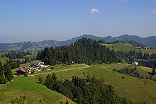
 View from the Pilatus on the Swiss plateau near Lucerne
In the north and northwest, the Swiss plateau is sharply delimited geographically and geologically by the Jura Mountains . In the south, there is no clear border with the Alps. Usually, the rising of the terrain to altitudes above 1500 metres AMSL (lime Alps, partly sub-alpine molasse), which is very abrupt in certain places, is taken as a criterion for delimination. Occasionally the regions of the higher Swiss plateau, especially the hills of the canton of Fribourg, the Napf region, the Töss region and parts of the Appenzell region are considered to form the Swiss Alpine foreland in a narrow sense. However, if a division into the three main regions Jura mountains, Swiss plateau and Alps is considered, the Alpine foreland belongs clearly to the Swiss plateau. In the southwest, the Swiss plateau is confined by Lake Geneva, in the northeast, by Lake Constance and the Rhine.
Geologically, the Swiss plateau is part of a larger basin that extends beyond the border of Switzerland. At its southwestern end, in France, the plateau, in the Genevois, ends at Chambéry where Jura and Alps meet. At the other side of the Lake Constance, the plateau continues in the German and Austrian Prealps.
Within Switzerland, the Swiss plateau has a length of about 300 km, and its width increases from the west to the east: In the Geneva region, it is about 30 km, at Bern about 50 km and in eastern Switzerland about 70 km.
Many cantons of Switzerland include a part in the Swiss plateau. Entirely situated within the Swiss plateau are the cantons of Zurich, Thurgau and Geneva; mostly situated within the Swiss plateau are the cantons of Lucerne, Aargau, Solothurn, Bern, Fribourg and Vaud; small portions of the Swiss plateau are situated in the cantons of Neuchâtel, Zug, Schwyz, St. Gallen and Schaffhausen.
Geology
Geological layers
The geological layers of the Swiss plateau are relatively well known. The base level is crystalline basement which outcrops in the central crystalline Alps as well as in the Black Forest and the Vosges mountain range but forms a deep geosyncline in the Swiss plateau and in the Jura (see also Jurassic). Around 2500 – 3000 metres below the surface, but considerably deeper near the Alps, the drillings have hit the crystalline basement. It is covered by unfolded strata of Mesozoic sediments, which are part of the Helvetic nappes. Its depth gradually decreases from about 2.5 km in the west to 0.8 km in the east. These layers, like the ones of the Jura mountains, were deposited in a relatively shallow sea, the Tethys Ocean. Above the Mesozoic layers, is the Molasse, consisting of conglomerate, sandstone, marl and shale. The uppermost layer consists of gravel and glacial sediments that have been transported by the glaciers of the ice ages.
Molasse
Geologically the most important layer of the Swiss plateau is the thick molasse sequence that accumulated at the border of the Alps due to the rapid erosion of the concurrently uplifted mountains. The thickness of the molasse increases from west to east (at the same distance from the Alps). The former Alpine rivers built huge fans of sediment at the foot of the mountains. The most important examples are the Napf fan and the Hörnli fan; other sedimentary fans exist in the Rigi region, in the Schwarzenburg region and in the region between the eastern lake Geneva and the middle reaches of the Saane/Sarine.
The eroded material has been sorted by grain size. The coarse material was predominantly deposited near the Alps. In the middle of the plateau, there are finer sandstones and near the Jura, clays and marl.
History of the Swiss plateau molasse
During the Tertiary orogenic uplift, around 60 – 40 millions years ago, the area of today's Swiss plateau was a Karst plateau somewhat inclined to the south. Through processes of rising and lowering that were brought by the folding of the Alps, the area was twice flooded by a sea. The corresponding sediments are distinguished as sea molasse and freshwater molasse, even though the latter consists rather of fluvial and eolian sediments (a kind of mainland molasse).
- Lower sea molasse (around 37 - 30 millions years ago): The limestone plateau subsided gradually, and a shallow sea invaded, spreading east to the Carpathian Mountains. The sediments consisted of fine-grained sands, clay and marl. There were no conglomerate fans since the proper Alpine folding began only at the end of that period.
- Lower freshwater molasse (around 30 - 22 millions years ago): The sea receded because of uplift, but also because of a worldwide lowering of the mean sea level. The initiation of the Alpine orogeny and subsequent folding and uplift resulted in rapid erosion accompanied by deposition of the first conglomerate fans.
- Upper sea molasse (around 22 - 16 millions years ago): For a second time, a shallow sea invaded. The formation of the conglomerate fans of the Napf and of the Hörnli began.
- Upper freshwater molasse (about 16 - 2 millions years ago): The sea receded as the formation and of the Napf and Hörnli fans continued (along with other minor fans). At the end of this period, the thickness reached about 1500 meters.
In the following time, especially the western part of the plateau was again significantly risen, so that in this area, the sediments of the upper sweetwater molasse and the upper sea molasse have been largely eroded.
A characteristic of the sea molasses are fossil snails, shells and shark teeth, whereas in the sweetwater molasse, fossils of typical land mammals and former subtropical vegetation (for instance palm leaves) are found.
The ice ages
The contemporary landscape of the Swiss plateau has been shaped by the ice age glaciers. During all the known alpine glaciations (Günz glaciation, Mindel glaciation, Riss glaciation and Würm glaciation), huge glaciers penetrated the Swiss plateau. During the warm interglacials, the glaciers receded to the high alps (sometimes more than today) and subtropical vegetation spread in the plateau.
 The Napf region in the higher Swiss plateau
During the ice ages, the Rhône glacier split into two branches when leaving the Alps, covering the whole western Swiss plateau reaching today's regions of Solothurn and Aarau. In the region of Bern it merged with the Aar glacier. The glaciers of the Reuss, the Limmat and the Rhine advanced sometimes as well until the Jura. The glaciers formed the land by erosion, but also by base moraines (very fine stone meal) often several meters thick, and by the meltwater streams depositing gravel.
Traces of the older Günz and Mindel glaciation are only left in a few places, because most has been removed or transferred by the later glaciations. The greatest extension was reached by the glaciers of the Riss glaciation, when the entire Swiss plateau was covered with ice except for the Napf and Töss regions. Most notable are the traces of the Würm glaciation about 15 000 years ago. The end moraines of different glacial retreats have been conserved.
Glacial landscapes
A look at a map still reveals the directions where the ice age glaciers ran. The farthest expansion of the Rhône glacier to the northeast is indicated by way the western Swiss plateau valleys trend: The valleys of the Broye and the Glâne as well as lake Murten, lake Neuchâtel, and lake Biel that trend all northeast, parallel to the Jura and to the Alps. The glaciers of the Reuss and the Limmat have carved the valleys of the central Swiss plateau that trend northwest (among others including the valleys of the Wigger, the Suhre, the Seetal, the Reuss and the Limmat). The Rhine glacier has mostly left traces that trend west: The eastern Swiss plateau Thur valley and lake Constance. In certain places, there are characteristic drumlins of base moraine, often clustered, especially in the highlands of Zurich, in the Hirzel region, in the lake Constance region and between the Reuss valley and the Lake Baldegg.
Another reminder of the glaciation are glacial erratics which are found all over the Swiss plateau. These rocks, sometimes of an enormous size, are of alien stones, mostly granite and gneiss from the central crystalline Alps. Taken together, they were one of the clues that led to the substantiation of the glaciation theory in the 19th century since a transport by water or by volcanism was physically impossible.
Gravel deposits in the bottoms of the valleys are another testimonial of the glaciation. During the advances and withdrawals of the glaciers, gravel layers were deposited in the valleys, sometimes quite thick, though most of it eroded in the subsequent interglacials. Therefore, many valleys have characteristic terraces, the lower terraces consisting of Würm glaciation gravel, the higher terraces of Riss glaciation terraces. Sometimes, there is also gravel from older glaciations.
Topography
 The Swiss plateau near Muri (AG)
Even though the Swiss plateau forms a basin, it is by no means a flat territory, but depending on the region, it has a manifold structure. Important elements are the two big lakes, Lake Geneva and Lake Constance that delimit the Swiss plateau in the southwest and the northeast. The western plateau is stamped by the Gros-de-Vaud plateau (up to 600 meters AMSL) and the Jorat molasse hills (up to 900 meters AMSL) but sometimes intersected by deep valleys. Only near the Jura there is an almost continuous dip consisting of the Venoge and the Orbe valleys which are separated by the Mormont hill, the main watershed between Rhône and Rhine, at only 500 meters AMSL. The Seeland ('lake land'), characterized by the Murten, Neuchâtel and Biel lakes, represents the biggest plain of the Swiss plateau, though it is also irrupted by isolated molasse ranges. In the east, it is neighboured by various hill countries the height of which decreases to the north. Another major plain is the Wasseramt where the Emme river runs. In a broad valley alongside the Jura, the Aar collects all the rivers that come down from the Alps.
 Central Swiss plateau near Sursee
The central Swiss plateau is characterized by a number of ranges and broad valleys, some of them with lakes, that run northwest. The last of them is the Albis range, which together with the Heitersberg range forms a bar from the Alps to the Jura that the major transportations bypass only in a few places, mostly in tunnels.
The eastern Swiss plateau is structured by the valleys of the Limmat (including lake Zurich), the Glatt, the Töss and the Thur. Between them there are hill countries, in the canton of Thurgau also the broad molasse ranges of Seerücken and Ottenberg.
Two hill countries get out of line of the mentioned landscapes: The Napf region (with 1408 meters AMSL the highest point of the Swiss plateau) and the Töss region (up to 1300 meters AMSL), both of them the remains of Tertiary conglomerate sediment fans. Since they were not glaciated, they have only been eroded by water, resulting in a dense net of deep, narrow valleys.
Climate
 View from the Rigi on the sea of fog covering the Swiss plateau
The Swiss plateau is situated within a transition zone between humid oceanic climate and continental temperate climate. The predominant wind comes from the west. In the lower plateau, the mean annual temperature is about 9 – 10 °C. In January, the lake Geneva region and the watersides of lake Neuchâtel and lake Biel have the highest mean temperature of about +1 °C. At the same height AMSL, the temperature is decreasing towards the east. In the lake Constance region, the mean temperature of the coldest month is -1 °C. In July, the mean temperature of Geneva is 20 °C, alongside the southern edge of the Jura it is 18 – 20 °C, and in higher regions 16 – 18 °C. With regard to mean sunshine duration, the lake Geneva region is again advantaged with more than 1900 hours, whereas in the rest of the Swiss plateau, it is between 1600 (especially in the east) and 1900 hours.
The annual average rainfall is between 800 millimeters near the Jura, 1200 millimeters in the higher regions and 1400 millimeters at the edge of the Alps. The driest regions of the plateau are in the lee of the High Jura between Morges and Neuchâtel. In the warmest regions at the lakes of Geneva and Neuchâtel, there are less than 20 days with a snow cover, whereas in the rest of the plateau, it is between 20 and 40, depending on the height.
In the winter half year, the air on the Swiss plateau can stay still, with little exchange to rest of the atmosphere, building a lake of cold air on the plateau and often a ceiling of high fog. The clouds look like an ocean of fog when seen from above, (usually around 800m) and hence is called the 'nebelmeer'. This weather is called inversion because the temperature below the fog is lower than the temperature above. Sometimes, it lasts for days or even for weeks, during which the neighbouring regions of the Alps and the Jura can have the brightest sunshine. Typical for the high fog is the bise, a cold wind from northeast. Since it is channelled by the Swiss plateau narrowing in southwest, it reaches its major strength in the lake Geneva region where wind speeds of 60 km/h with top speeds of more than 100 km/h are usual in typical bise weather. The regions near the Alps of the central and eastern plateau sometimes have temperature rises due to the warm foehn wind.
Vegetation
The dominating vegetation in the Swiss plateau is mixed broadleaf forest with European Beeches and Silver Firs. For forestry, there are major plantations of Norway Spruces in many places, though the Norway Spruce naturally only grows in the mountains. In certain favoured spots that are warmer and drier, in the lake Geneva region, in the Seeland and in northern plateau between the Aar orifice and Schaffhausen, the predominant trees are oak, tilia and maple.
Population
 Much of the eastern part of the plateau has become part of the "Greater Zurich Area".
Even though the Swiss plateau takes only about 30% of the surface of Switzerland, 5 million people live there, which constitutes more than two thirds of the Swiss population. The population density is 380 people per square kilometer. All the Swiss cities with more than 50 000 inhabitants except Basel and Lugano are situated in the plateau, especially Bern, Geneva, Lausanne and Zurich. The agglomerations of these cities are the most populous areas. Other densely populated areas are the south edge of the Jura and the agglomerations of Lucerne, Winterthur and St. Gallen. Regions of the higher Swiss plateau like the Jorat region, the Napf region or the Töss region are comparatively scarcely populated with little farming villages and scattered farms.
 The densely populated Swiss plateau: view of Waidberg in Zurich
A majority is German-speaking, though the west is French-speaking. The language border has been stable for many centuries even though it falls neither on a geographical nor on a political delimitation. It passes from Biel/Bienne over Murten/Morat and Freiburg/Fribourg to the Fribourg Alps. The cities of Biel/Bienne, Murten/Morat and Freiburg/Fribourg are officially bilingual. Localities along the language border have usually both a German and a French name.
History of settlement
The first areas to be settled in the Neolithic were the watersides of lakes and rivers. Major oppida were built after the Celts appeared in the 3rd century BC. Urban settlements with stone houses were built during the Roman Empire. The Swiss plateau became a part of the Roman Empire 15 BC when the Romans occupied the land of the Helvetii under the reign of Augustus and it remained Roman until the end of the 3rd century. The most important Roman cities in the Swiss plateau were Auenticum (today Avenches), Vinddonissa (today Windisch), Colonia Iulia Equestris or, by its Celtic name, Noviodunum (today Nyon) and Augusta Raurica (today Kaiseraugst). They were well connected by a net of Roman roads. After the retreat of the Roman Empire, the western Swiss plateau was occupied by the romanized Burgundians, the central and the eastern plateau by the Alamanni, thus emerging the language border.
During the Middle Ages many towns were founded, especially in the climatically more favoured lower plateau. In 1500, there were already 130 towns, connected by a dense road network. With the raise of the industrialisation in the early 19th century, the cities became more and more important. In 1860, a drastic population growth of the cities started which lasted for about 100 years. In the 1970s, however, an outmigration from the cities started. Therefore, the municipalities surrounding the cities grew disproportionately, whereas the cities themselves lost inhabitants. In the recent times, the outmigration has moved farther away from the cities.
Economy

Thanks to favourable climate and fertile grounds, the lower western plateau is the most important agricultural region of Switzerland. The most important cultures are wheat, barley, maize, sugar beet and potato; especially in the Seeland, vegetables are very important, too. Along the northern shores of the lakes of lake of Geneva, lake of Neuchâtel, lake of Bienne, lake of Morat, as well as in the Zürich Weinland and Klettgau, there is viticulture. Grassland with dairy farming and beef production is predominant in the eastern plateau and in the higher regions. Especially in the Thurgau, fruit (apples) is important.
The forests in the Swiss plateau are used in forestry. There are many Norway Spruce forestations, often in monoculture because of their valuable timber.
 Nuclear power plant (Leibstadt)
With respect to industry, the plateau is the most important region of Switzerland. The traditional textile industries are situated especially in the central and eastern regions. During the last decades, however, it lost importance. Today's most important industries are the machine industry, the automotive industry, the electrical industry, the fine & micro mechanical, watch & electronic industries, next to the optical and metal construction's. The food industry processes domestic as well as foreign produces. Furthermore, wood processing and paper converting are also important.
Like all Switzerland, there are few mineral resources. Thanks to the Ice Age glaciers, there is plenty of gravel and clay. The gravel digging in the Ice Age gravel terraces all over the Swiss plateau covers the demands of the construction industry.
Numerous hydroelectric power plants in the rivers produce electricity. All four Swiss nuclear power plants are situated in the plateau.
Transportation
Because of the comparatively easy topography and the dense population, the transport network is highly developed. The most important transversal, so to speak the backbone of the Swiss plateau, is the A1 motorway that connects all the big cities going from Geneva over Lausanne, Bern, Zurich and Winterthur to St. Gallen. The A2, the Swiss north-south axis, crosses the plateau from Olten to Luzern.
The railway network is very dense. All major cities are connected, and between Olten and Lausanne there are two main lines: One passing over Bern and Fribourg, the other passing over the edge of the Jura with Solothurn, Biel, Neuchâtel and Yverdon-les-Bains. The train ride from Zurich to Bern takes one hour; crossing the entire Swiss plateau from St. Gallen to Geneva takes four hours.
The two most important Swiss airports are situated in the plateau, Zurich International Airport and Geneva Cointrin International Airport. The capital of Switzerland, Bern, has only a small airport, Bern Belpmoos Airport.
Tourism
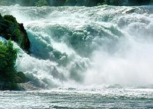 The Rhine Falls
Other than the Swiss Alps, the plateau, and especially the rural plateau, is not geared to tourism. It is mainly a transit region. There is city tourism in the major cities with their touristical attractions, especially the Old Towns of Bern and Lucerne, but also Zurich, St. Gallen, Fribourg, Geneva and Lausanne. An important natural touristic attraction is the Rhine Fall near Schaffhausen. The lakes also attract tourists, and then there are several spa towns, Baden, Schinznach-Bad, Yverdon-les-Bains and Zurzach, thanks to their hydrothermal vents.
See also
References
Much of the content of this article comes from the equivalent German-language Wikipedia article (retrieved July 26, 2005). The following references are cited by that German-language article:
- Toni P. Labhart: Geologie der Schweiz. Ott Verlag, Thun, 2004. ISBN 3-7225-6762-9.
- François Jeanneret und Franz Auf der Maur: Der grosse Schweizer Atlas. Kümmerly + Frey, Geographischer Verlag, Bern, 1992. ISBN 3-259-08850-4.
- Andre Odermatt und Daniel Wachter: Schweiz, eine moderne Geographie. Neue Zürcher Zeitung, Zürich, 2004. ISBN 3-03823-097-9.
External links
- (German) Geologie der Schweiz
- (German) Geologie des Mittellandes
- Mittelland in German, French and Italian in the online Historical Dictionary of Switzerland.
Categories:- Geography of Switzerland
- Regions of Switzerland
- Helvetii


Wikimedia Foundation. 2010.