- City of Burnside
-
City of Burnside
South Australia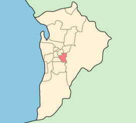
Population: 44,300(2009)[1] • Density: 1553.7/km² (4,024.1/sq mi) Area: 27.53 km² (10.6 sq mi) Mayor: David Parkin Council Seat: Tusmore Region: Metropolitan Adelaide State District: Adelaide, Bragg, Morialta, Hartley, Heysen, Norwood Federal Division: Sturt 
LGAs around City of Burnside: Adelaide Norwood Payneham St Peters Campbelltown Unley City of Burnside Adelaide Hills Mitcham Mitcham Adelaide Hills The City of Burnside is a local government area with an estimated population of 44,300 people in the South Australian city of Adelaide.[1] Burnside was founded in August 1856 as the District Council of Burnside, and was classed as a city in 1943. It is named after the property of an early settler and stretches from the Adelaide Parklands into the Adelaide foothills. It is bounded by Adelaide, Adelaide Hills Council, Campbelltown, Mitcham, Norwood Payneham and St Peters and Unley. The city has an area of 27.53 km².
A primarily residential area, Burnside has little to no industrial activity and a small commercial sector. Over 2.57 km² of its area is dedicated to Parks and Reserves, the result being one of the greenest areas in Adelaide. As one of the eastern suburbs adjacent to and entering the foothills, Burnside is also known as being relatively wealthy compared to the Adelaide average. It was one of the first areas outside of Adelaide to be settled, with the early villages of Magill, Burnside, Beaumont and Glen Osmond now inner suburbs. At the 2006 census, the City had a SEIFA score of 1108 (96th percentile), which was the highest figure for any local government area in South Australia — individual CCD scores ranged from 909 in eastern Glenside to 1194 in Stonyfell.[2]
Contents
History
Main article: History of BurnsideBurnside was inhabited by the Kaurna Indigenous tribe prior to European Settlement, with the natives living around the creeks of the River Torrens during the summer months and living in the Adelaide Hills during the wintertime. The area was first settled in 1839 by Peter Anderson, a Scots migrant, who named it Burnside after his property's location adjacent to Second Creek (in Scots, 'Burn' means creek or stream). The Village of Burnside was established shortly thereafter and the Burnside Council District was gazetted in 1856, separating itself from the larger East Torrens Council. Beaumont House, a historic structure, was constructed for the first bishop of Adelaide, Augustus Short, during 1851. Wineries, mining and olive groves were the mainstay of an early Burnside economy; Glen Osmond boasted substantial mineral deposits and world-class vineyards were established at Magill. The present Council Chambers were built in 1927/8 in Tusmore, with the council becoming a municipality in 1935. With strong growth and development throughout the region, Burnside was then proclaimed a city in 1943. The 1960s' brought to Burnside a community library and a swimming centre, both were further expanded and upgraded between 1997 and 2001. Today Burnside is one of Adelaide's most sought-after regions in which to live, the Council is in the progress of implementing its Vision 2020 plan.
Geography

Burnside is in an area of 27.53 km² (2,753 hectares) and located to the south-east of the Adelaide CBD's parklands, extending to the Cleland Conservation Park in the Mount Lofty Ranges. Two creeks of the River Torrens run through a gradually sloping plain from the ranges, there is much variation in land use and topography.
Before European Settlement in South Australia much of the Adelaide Plains was swamps and woodland. In what was to become Burnside, plains leading out to Unley hosted the large Black Forest of Grey Box woodland, to the north the floodplains of First and Second Creeks there was Blue Gum and River Red Gum. Nearer to the foothills, in Mount Osmond and Waterfall Gully a more diverse range of plant species existed; Manna Gum and Blue Gum were predominant however. With colonisation underway, much of the native foliage was cut down to be used for crops and grazing. Market Gardens in the Adelaide Hills lowered the amount of water flowing down the creeks and some of the Hills Face was used for quarrying. Early crops grown included olive groves, grapes for winewaking, wheat and barley. Agriculture greatly declined and only vineyards survive today in Magill and Waterfall Gully.
With new suburbs being gazetted in the 20th century, the Burnside Council undertook ambitious tree-planting, beautification and conservation schemes to slow and then reverse a negative impact on the natural environment. 190 hectares of the council area is held in reserves and parks and some 35,000 trees line the streets. A 'Second Generation Tree Planting Program' has been underway since 1993. Notable parks and reserves include Chambers Gully, Langman Reserve and Hazelwood Park.
Governance
Council
The Burnside city council is divided into the following wards:
- Kensington Park (Beulah Park, Hazelwood Park, Kensington Park and Leabrook)
- Kensington Gardens & Magill (Auldana, Kensington Gardens, Magill, Rosslyn Park and Skye)
- Burnside (Burnside, Erindale, Stonyfell and Wattle Park)
- Beaumont (Beaumont, Leawood Gardens, Linden Park, Mount Osmond, St Georges and Waterfall Gully)
- Eastwood & Glenunga (Eastwood, Frewville, Glen Osmond, Glenside and Glenunga)
- Rose Park & Toorak Gardens (Dulwich, Rose Park, Toorak Gardens and Tusmore)
 Burnside library
Library
Main article: Burnside libraryBurnside library is the only public in the city of Burnside. It is adjacent to the Council offices and is part of the civic centre. The library is open seven days a week, from 9.30am-6pm on weekdays, except Thursday when it closes at 9pm, and on the weekend from 10am-4pm on Saturday and 2pm-5pm on Sunday.[citation needed]
Politics
Bragg 2010 State Election
Party % Liberal Party of Australia 64.0% Australian Labor Party 20.6% Australian Greens 12.5% Family First Party 2.9% For State Government Burnside is part of the Electoral Districts of Adelaide, Bragg, Morialta, Hartley, Heysen, Norwood and Unley. Bragg takes in most of the city; it is the strongest Liberal Party district in the Adelaide Metropolitan Area and the third strongest in the state. Liberal strength is strongest in the wealthy hills suburbs to the south-east around Beaumont and weakest around Norwood in the north where the Labor Party dominates. Before their catastrophic collapse in recent years, the Democrats polled impressive results in the western near-city suburbs. The Greens gained much of the previous Democrats vote in recent elections. Bragg has been held by Vickie Chapman, Shadow Attorney-General of the State Liberal Party, since 2002.
Burnside forms the southern part of the Federal Division of Sturt, which takes in much of Adelaide's eastern suburbs, stretching from Paradise to Glen Osmond. Up until the 2007 Federal Election, it was a safe Liberal seat for over thirty years. At the election, on a two-party preferred basis, the Liberal Party gained 50.94% of the vote and the Labor Party 49.06%, a difference of only 1,712 votes. The current member is Liberal Moderate Christopher Pyne, the Shadow Education Minister, who has held the seat since 1993.
An inquiry was launched in 2009 by then state Local Government Minister Gail Gago into allegations of "harassment, bullying and misconduct" by then members of the City Council.[3] After about $200,000 of expenditure by the council and $1.3 million by the state government, legal action by former councilors prevented the release of the report.[4] A Supreme Court ruling on 27 May 2011, found that the report could be partially released, after material related to parts of the terms of reference deemed inappropriate was redacted.[5]
Demographics
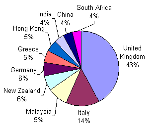
 Graph displaying the birthplaces of the quarter of the population born abroad
The population of the City of Burnside, at the time of the 2001 census, was 40,398. This was an increase of 1,308 from the 1996 census. 53.3% of the population is female and 73.6% were born in Australia. Burnside is characterised by what is called an 'urban mix' by demographers; it contains a diverse range of age, family and household types. There are 16,835 households in Burnside, 10,917 of these are self-described families. 45% of families represent a couple with children, 11.% represent a sole-parent family and 43.1% are couples without children (or whose children have left home). The large amount of couples without children (5.6% higher than the Adelaide average) owes to the sizeable elderly population. Almost a quarter (23.7%) of the population is aged 60 or over, almost a third (29.9%) is 24 or younger; mature adults are the largest population group at 46.4%. This would indicate a structure primarily of mature families and retirees, young adults are hugely unrepresented (although this is not unique to Burnside, this phenomenon is common throughout the majority of the Adelaide region); the 18-24 age group suffered a loss of 330 people between 1996 and 2001.
26.3% of the population was born abroad, less than the Adelaide average. 9% of the population came from English-speaking countries, while 14.3% did not. In decreasing order, the foreign-born population was from the United Kingdom, Italy, Malaysia, New Zealand, Germany, Greece, Hong Kong, India, China and South Africa. These patterns are broadly in-line with that of Australia as a whole; they reflect traditional immigration from Commonwealth countries such as the United Kingdom and New Zealand, later waves of Mediterranean migrants and more recent arrivals from Asia.
Religious adherence in Burnside is higher than the Adelaide and Australian average, standing at 71.7%. Of this adherence, 67.6% represents traditional Christian denominations. Common across Australia and many developed countries, there has been a substantial decline in religiosity; this is evident but less marked in Burnside; 17.7% of residents profess no religious belief (atheism, agnosticism, etc.). The ten strongest religions/denominations in decreasing order are: Catholic, Anglican, Uniting, Orthodox, Lutheran, Baptist, Buddhism, Presbyterian, Judaism and Hinduism. Catholicism is unique for its marked increase (575 persons) in believers between 1996 and 2001, most other religions' numbers remained stable or saw a slight decrease.
Economy
 The Burnside Village shopping centre.
Burnside has no manufacturing industries and a small amount of agricultural plots still exist in the form of vineyards. It does however contain a sizeable amount of service industry; high-technology and commercial offices line the streets opposite the central business district.
Burnside workers are employed in the Industries of Education, Health and Community Services (27%); Finance, insurance and business services (22.5%); wholesale and retail trade (16%); recreation and personal services (11.2%) and manufacturing (7.7%). In these industries they are employed as: Professionals (35.5%); clerks, salespersons and service (26.2%); Associate Professionals (13.7%); Managers and Administrators (12.4%) and tradepersons (4.8%). The relatively large share of workers employed in professional and high-end fields translates to high incomes; the highest-earning household income percentile is also the largest in Burnside at 16.3% (A$2000 or more per week). 12.7% of households earn $1500–1999 per week, 8% earn $800–900, 7.7% earn $1000–1999 and 7.5% earn $200–299. The sizeable share of low-earning households in an otherwise wealthy area is mostly due to university students living near the city centre; close near-city suburbs such as Dulwich, Rose Park and Toorak Gardens have higher percentages of low-earners. The wealthiest suburbs are concentrated around the south-eastern foothills, centred on Beaumont.
Education
Burnside has two public high schools, Glenunga International High School and the Magill campus of the Norwood Morialta High School, in its boundaries. Glenunga High remains at capacity through student enrolment from overseas and outside the local area. Its beginnings can be traced back to 1898; it was first established as the South Australian School of Mines and Industries on North Terrace, its original buildings there are now part of the University of Adelaide campus. It changed name to Adelaide Technical High School in 1918. With the move to its current location at Glenunga in 1963 the name was eventually changed to Glenunga High School a decade later. The school attained International Baccalaureate accreditation in 1990 and 'International' was added to its title. Marryatville High School is also on the boundaries of Burnside and draws most of its students from Burnside. There are also Burnside Primary School and Linden Park Primary School, both years Rec-7 public schools.
Culture
Youth
There is an annual Battle of the Bands held at Burnside Town Hall.[citation needed]
Music
The Burnside Symphony Orchestra is based in the council area, and performs up to 4 concerts annually in the Burnside Ballroom at the Town Hall.[6]
Infrastructure
Health
 The hospital from Kensington Road.
The Burnside War Memorial Hospital is the only community hospital in Burnside operating today. A local resident of Toorak Gardens, Otto George Ludwig Van Rieben, offered his Attunga property for use as a community hospital free of charge in 1944. The Council had first suggested building a community hospital in August 1943 as part of its Post-War Reconstruction and Development Committee; it was to cost 100 000 pounds and to remain as a memorial to honour Burnside's war dead. In April 1949 the first conversion of Van Rieben's home was complete and the hospital was caring for 21 patients. The hospital closed for a month in 1956 and when it reopened was given its present name: The Burnside War Memorial Hospital. The hospital is not-for-profit and reinvests all surplus into upgrading facilities, equipment and services.
The Queen Victoria Hospital in Rose Park operated until 1995 when it was amalgamated with the Women's and Children's Hospital and the original building was sold and converted into apartments. It opened in 1902 with a grant of 2550 pounds and was originally known as 'The Queen's Home' as it opened on the birth date of Queen Victoria, 24 May 1902. It was renamed in 1939 to the 'Queen Victoria Maternity Hospital' and under the Hospital Benefits Act of 1946 became a public hospital. Over 250 000 South Australians began their lives at the hospital.
Transport
 The Burnside Road Network.
Burnside is located at a transport crossroads for national freight movements. Freight traffic from Victoria diverges down Glen Osmond and Portrush Roads upon entering the metropolitan area via the Adelaide-Crafers Highway (Mount Barker Road) and the South Eastern Freeway. Both roads carry an almost equal amount of freight traffic, Glen Osmond leads to the airport and Outer Harbor while the Portrush route connects to the northern industrial suburbs, the state's north, Western Australia and the Northern Territory. In addition, they act as major commuter arteries for the Adelaide Hills and form the eastern part of Adelaide's outer bypass route. The Adelaide-Crafers highway was completed in 1999 and Portrush Road saw an extensive upgrade throughout 2003–2004.
Other major commuter roads include Kensington, Magill and Greenhill Roads, which run east-west. Glynburn and Fullarton Roads provide secondary north-south corridors, the former runs close to the foothills and alleviates congestion on Portrush while the latter forms part of Adelaide's inner bypass route. Maintenance of the extensive road network is a State Government responsibility; the Federal Government provides funding for nationally important AusLink routes. Council provides recommendations to projects and participates in the upkeep of the curbs, frontage, footpaths and minor signage.
Burnside residents rely overwhelmingly on cars as a means to travel to work; 64.3% drive their own vehicle and 5.6% are a regular passenger in one. 5.8% use public transport, in the form of Adelaide Metro buses, for their commute; 1.2% bicycle and 2.3% walk. Non-vehicular travel is on the rise, with usage higher than the Adelaide average and an increase in persons doing so between 1996 and 2001. 38% of Burnside households own one vehicle, 26.8% own two and 12.3% own three vehicles or more. Burnside and suburbs east of the city were served by an excellent tramway system that was shut down in the 1950s.
 Portrush Road
With the advent of widespread automobile travel in the mid 20th century there was a tendency for motorists to use local roads in suburbs adjacent to the CBD for their commute home. 'Rat trails' of cars sneaked through narrow side-streets, presenting traffic bottlenecks. This was a particular problem for some western Burnside suburbs because of their location. Various traffic control methods were put in place (closing streets, speed bumps, lowered speed limits, roundabouts) to counter these problems; this forced the re-routing of traffic onto major thoroughfares.
Utilities
Burnside is connected to the Adelaide water, power and gas mains. Until recently, many of the foothills suburbs did not have access to sewage systems and used septic tanks. This had been rectified in the last decade in a partnership between SA Water and the Burnside Council.
Adelaide has three major energy companies, which provide gas and electricity to the population: ETSA Utilities, AGL, EnergyAustralia and Origin Energy. Burnside derives its electricity via the Adelaide grid from a gas-fired plant at Torrens Island. Burnside's water supply is gained from the Adelaide area reservoirs: Mount Bold, Happy Valley, Myponga, Millbrook, Hope Valley, Little Para and South Para. Further water demands result in the pumping of water from the River Murray. The provider of water services is by the government-owned SA Water. In early times, Burnside's creeks contributed to Adelaide's water supply. With enlarged market gardens upstream in the Adelaide Hills the water level and quality dropped and this was no longer feasible.
Council maintenance services are located at the Council Depot on Glynburn Road in the suburb of Burnside.
References
- ^ a b Australian Bureau of Statistics (30 March 2010). "Regional Population Growth, Australia, 2008–09". http://www.abs.gov.au/ausstats/abs@.nsf/Latestproducts/3218.0Main%20Features72008-09?opendocument&tabname=Summary&prodno=3218.0&issue=2008-09&num=&view=. Retrieved 4 June 2010.
- ^ Australian Bureau of Statistics (25 March 2009). "2033.0.55.001 - Census of Population and Housing: Socio-Economic Indexes for Areas (SEIFA), Australia - Data only, 2006". http://www.abs.gov.au/ausstats/abs@.nsf/mf/2033.0.55.001/. Retrieved 24 September 2010.
- ^ "Police called to Burnside council meeting". ABC News. 7 July 2009. http://www.abc.net.au/news/stories/2009/07/07/2618596.htm.
- ^ "$195,000 bill for Burnside inquiry". The Advertiser. 16 May 2011. http://www.adelaidenow.com.au/news/south-australia/bill-for-burnside-inquiry/story-e6frea83-1226057041043.
- ^ Heather Kennett (27 May 2011). "Ruling paves way for release of Burnside report". Eastern Courier Messenger. http://eastern-courier-messenger.whereilive.com.au/news/story/ruling-paves-way-for-release-of-burnside-report/.
- ^ Burnside Symphony Orchestra website
External links
City of Burnside History of Burnside · Burnside Civic Centre · Burnside War Memorial Hospital · Burnside Village
Auldana · Beaumont · Beulah Park · Burnside · Dulwich · Eastwood · Erindale · Frewville · Glen Osmond · Glenside · Glenunga · Hazelwood Park · Kensington Gardens · Kensington Park · Leabrook · Leawood Gardens · Linden Park · Magill · Mount Osmond · Rose Park · Rosslyn Park · St Georges · Skye · Stonyfell · Toorak Gardens · Tusmore · Waterfall Gully · Wattle ParkLocal Government Areas of South Australia Metropolitan Adelaide Adelaide · Adelaide Hills · Burnside · Campbelltown · Charles Sturt · Gawler · Holdfast Bay · Marion · Mitcham · Norwood Payneham & St Peters · Onkaparinga · Playford · Port Adelaide Enfield · Prospect · Salisbury · Tea Tree Gully · Unley · Walkerville · West TorrensEyre Peninsula Ceduna · Cleve · Elliston · Franklin Harbour · Kimba · Lower Eyre Peninsula · Port Augusta · Port Lincoln · Streaky Bay · Tumby Bay · Wudinna · WhyallaCentral Barossa · Barunga West · Clare and Gilbert Valleys · Copper Coast · Flinders Ranges · Goyder · Light · Mallala · Mount Remarkable · Northern Areas · Orroroo Carieton · Peterborough · Port Pirie · Wakefield · Yorke PeninsulaSouthern and Hills Murray Mallee Southeast Outback Categories:- Local Government Areas of South Australia
- Local Government Areas in Adelaide


Wikimedia Foundation. 2010.